The instrument's own words
page 1 · read by Gemma vision
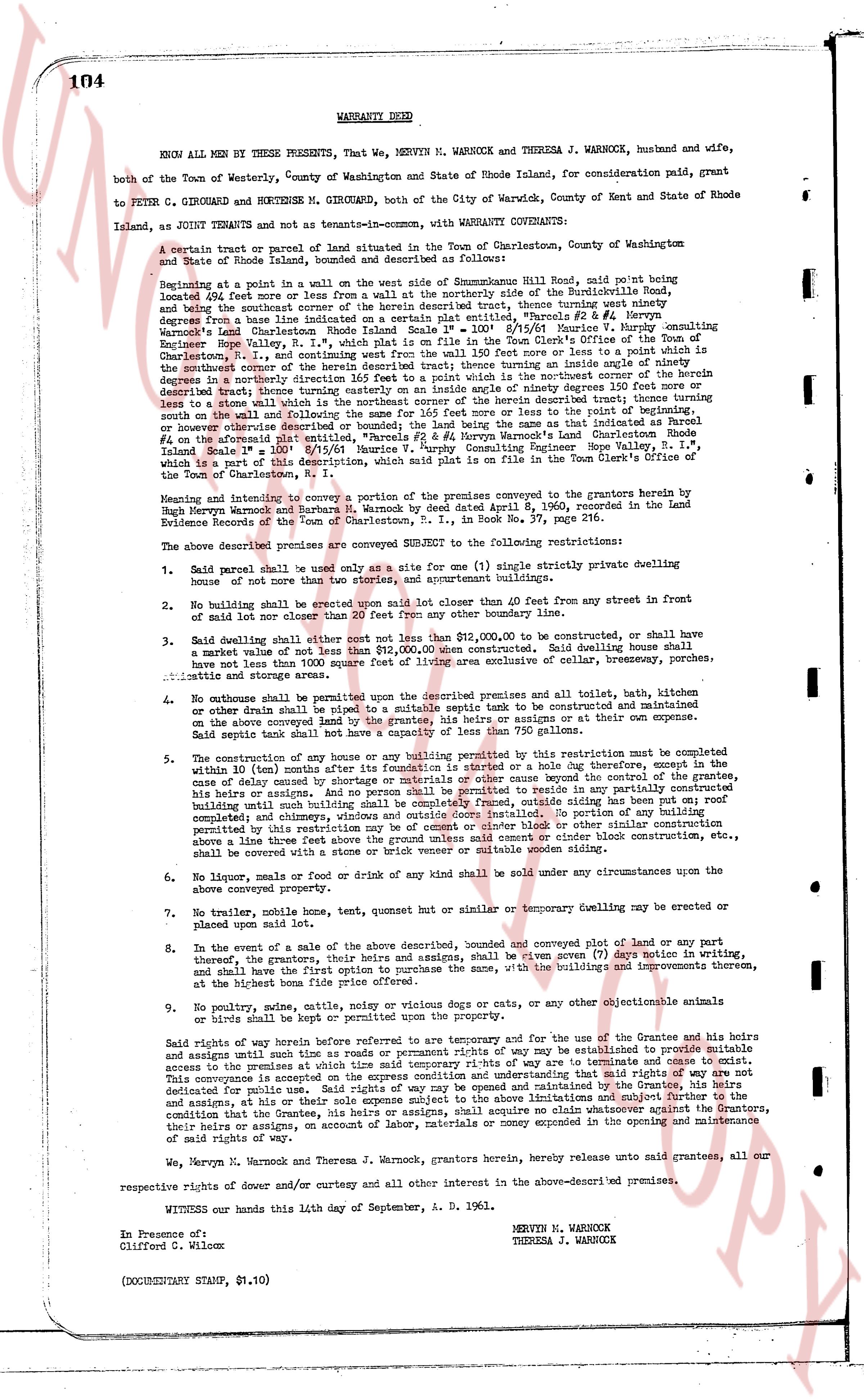
104 WARRANTY DEED
KNOW ALL MEN by THESE PRESENTS, That WE, MERVYN M. WARNOCK and THERESA J. WARNOCK, husband and wife,
both of the Town of Westerly, County of Washington and State of Rhode Island, for consideration paid, grant
to PETER C. GIROUARD and HORTENSE M. GIROUARD, both of the City of Warwick, County of Kent and State of Rhode
Island, as Joint tenants with Tenancy-in-common, with WARRANTY COVENANTS:
A certain tract or parcel of land situated in the Town of Charlestown, County of Washington and
State of Rhode Island, bounded and described as follows:
Beginning at a point in a wall on the west side of Southquamme Hill Road, said point being
located 494 feet more or less from a wall at the northerly side of the Narragansett Road,
and being the northwest corner of the herein described tract; thence turning west ninety
degrees from a base line indicated on a certain plat entitled, "Parcels #2 & #4 Warnock's
Land" charted by Charles R. S. S.V.E. dated 8/15/61 found in Movie's consulting
Engineer Hope Valley, R.I., which plat is on file in the Town Clerk's Office of the Town
Charlestown, R.I., south 81 degrees 15 minutes west 111.30 feet or more or less to a point
in the southwestern corner of the herein described tract; thence turning an inside angle of ninety
degrees then south 16 degrees 45 minutes east 151.30 feet or more or less to the southeast corner
described tract; thence turning easterly on an inside angle of ninety degrees 210 feet more or
less to a stone wall; thence turning north 81 degrees 15 minutes east 111.30 feet or more or
less to a point; thence turning south 16 degrees 45 minutes east 210 feet or more or less to
the southernmost point; and finally for 366 feet more or less following the line of the road or
boundary or however otherwise described or bounded; to the point of beginning; said tract
being composed of Parcels #2 & #4 Warnock's Land charted by Movie's consulting Engineer
Hope Valley S.V.E., dated 8/15/61 found in Movie's consulting Land's Charlestown Rhode
Island Scale 1" = 100' found in Movie's consulting Engineer Hope Valley S.V.E., which
plat is a record of the plat filed in the Town Clerk's Office of the Town
of the Town of Charlestown, R.I.
Meaning and intent to convey a portion of the premises conveyed to the grantors herein by
Mervyn M. Warnock and Theresa J. Warnock by Deed dated April 8, 1960, recorded in the Land
Evidence Records of the Town of Charlestown, R.I., in Book No. 37, page 216.
The above described premises are conveyed SUBJECT to the following restrictions:
1. Said parcel shall be used only as a site for one (1) single strictly private dwelling
house of not more than two stories, and appropriate servant buildings.
2. No building shall be erected on said premises closer than 40 feet from any street in
front of the property nor within 20 feet from any other boundary line.
3. Said dwelling shall cost not less than $12,000.00 to be constructed, said dwelling house
shall a market value of not less than $12,000.00 when completed. Said dwelling house shall
have not less than 1000 square feet of living space exclusive of cellar, hallways, porches, garages,
attics and storage areas.
4. No outhouse shall be permitted upon the described premises and all toilet, bath, kitchen
or other utilities shall be piped to a suitable septic tank to be constructed and maintained
on the above conveyed land by the grantee, his heirs or assigns at their or its own expense.
Said septic tank shall not be less than 10 feet in length and 750 gallons.
5. The construction of any new house or any building permitted by this restriction must be
completed within 10 (ten) months after its foundation is settered or a date on this day thereof, except in the
case of delay caused by act of God, war, strike or other cause beyond the control of the grantee,
his heirs or assigns; and no person shall be permitted to reside in any partially constructed
building until such building shall be completed including roof, ceiling and siding, and all
roofing and heating equipment shall be installed. No portion of any building
permitted by this restriction may be of cement or cinder block or other similar construction
above a three feet high foundation wall; and any building of cement or cinder block construction etc.,
shall be covered with a stone or brick veneer or suitable wooden siding.
6. No liquor, meals or food, or drink of any kind shall be sold under any circumstances upon the
above conveyed property.
7. No trailer, mobile house, tent, guest house or similar or temporary dwelling may be erected or
placed upon said lot.
8. In the event of a sale of the above described, bounded and conveyed plot of land or any
part thereof, the grantor, their heirs and assigns shall, be given 7 (seven) days notice in writing,
and shall have the first option to purchase same, with the buildings and improvements thereon,
at the highest bona fide price offered thereof.
9. No poultry, dogs, cats, other noisy or vicious dogs or cats, or any other objectionable animals
or birds shall be kept on or about the property.
Said rights of way herein before referred to are temporary and are for the convenience of the Grantee and his
assigns until such time as roads or permanent rights of way may be established to provide suitable
access to the premises; all such roads or permanent rights of way may be established to provide suitable
access to the premises at the sole expense of the Grantee, his heirs or assigns.
This conveyance is accepted on the express condition and understanding that said rights of way are not
dedicated for public use and that the Grantee, his heirs or assigns, shall maintain whatever roads or ways,
his assigns, at his or their sole expense subject to the above imitations and subject further to the
condition that the Grantee, his heirs or assigns, shall indemnify and save harmless whatever roads or ways,
their heirs or assigns, on account of labor, materials or money expended in the opening and maintenance
of said rights of way.
We, Mervyn N. Warnock and Theresa J. Warnock, grantors herein, hereby release unto said grantees, all our
respective rights of dower and/or curtesy and all other interest in the above-described premises.
WITNESS our hands this 14th day of September, A. D. 1961.
MERVYN M. WARNOCK
THERESA J. WARNOCK
In Presence of:
Clifford G. Wilcox
(DOCUMENTARY STAMP, $1.10)
page 2 · read by Gemma vision
STATE OF RHODE ISLAND )
COUNTY OF WASHINGTON )
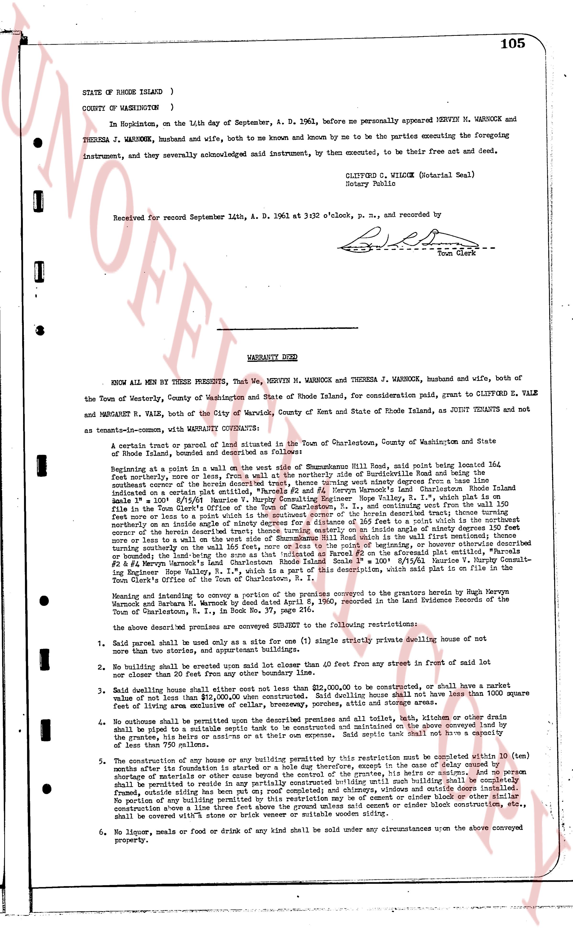
In Hopkinton, on the 14th day of September, A. D. 1961, before me personally appeared MERVYN M. WARNOCK and THERESA J. WARNOCK, husband and wife, both to me known and by me known and by me to be known and by me to be the parties executing the foregoing instrument, and they severally acknowledged said instrument, by them executed, to be their free act and deed.
CLIFTON D. WILCOX (Notary Seal)
Notary Public
Received for record September 14th, A. D. 1961 at 3:32 o'clock, p. m., and recorded by [signature] Town Clerk
----
WARRANTY DEED
KNOW ALL MEN BY THESE PRESENTS, That We, MERVYN M. WARNOCK and THERESA J. WARNOCK, husband and wife, both of the Town of Westerly, County of Washington and State of Rhode Island, for consideration paid, grant to CLIFFORD E. VALE and MARGARET R. VALE, both of the City of Warwick, County of Kent and State of Rhode Island, as JOINT TENANTS and not as tenants-in-common with WARRANTY COVENANTS:
A certain tract or parcel of land situated in the Town of Charlestown, County of Washington and State of Rhode Island, bounded and described as follows:
Beginning at a point in a wall on the west side of Shannockum Hill Road, said road being located 364 feet northerly, more or less, from a wall on the northerly side of South County Road and being the southeast corner of the herein described tract of land, running west ninety degrees from a base line indicated on a certain plat entitled, "Parcels #1 and #2, Mervyn Warnock's Land Charlestown Rhode Island Scale 1" = 100' 8/15/61" drawn by [?] [?] surveyor, Providence, R. I., a record copy of which is on file in the Town Clerk's Office of the Town of Charlestown, R. I., and continuing west from the wall 150 feet more or less to a point in a wall, thence running northerly ninety degrees for a distance of 165 feet to a point which is the northeast corner of the herein described tract of land, thence running westerly ninety degrees for a distance of 364 feet more or less to a wall on the west side of Shannockum Hill Road which is the wall (first mentioned) thence running southerly on the and along the said wall a distance of 165 feet to the point of beginning, or otherwise described or bounded, the said land being the zone as that indicated as Parcel #2 on the aforesaid plat entitled, "Parcels #1 & #2, Mervyn Warnock's Land Charlestown Rhode Island Scale 1" = 100' 8/15/61" and the [?] [?] [?] [?] [?] [?] [?] [?] [?] [?] [?] [?] [?] [?] [?] [?] [?] [?] [?] [?] [?] [?] [?] [?] [?] [?] [?] [?] [?] [?] [?] [?] [?] [?] [?] [?] [?] [?] [?] [?] [?] [?] [?] [?] [?] [?] [?] [?] [?] [?] [?] [?] [?] [?] [?] [?] [?] [?] [?] [?] [?] [?] [?] [?] [?] [?] [?] [?] [?] [?] [?] [?] [?] [?] [?] [?] [?] [?] [?] [?] [?] [?] [?] [?] [?] [?] [?] [?] [?] [?] [?] [?] [?] [?] [?] [?] [?] [?] [?] [?] [?] [?] [?] [?] [?] [?] [?] [?] [?] [?] [?] [?] [?] [?] [?] [?] [?] [?] [?] [?] [?] [?] [?] [?] [?] [?] [?] [?] [?] [?] [?] [?] [?] [?] [?] [?] [?] [?] [?] [?] [?] [?] [?] [?] [?] [?] [?] [?] [?] [?] [?] [?] [?] [?] [?] [?] [?] [?] [?] [?] [?] [?] [?] [?] [?] [?] [?] [?] [?] [?] [?] [?] [?] [?] [?] [?] [?] [?] [?] [?] [?] [?] [?] [?] [?] [?] [?] [?] [?] [?] [?] [?] [?] [?] [?] [?] [?] [?] [?] [?] [?] [?] [?] [?] [?] [?] [?] [?] [?] [?] [?] [?] [?] [?] [?] [?] [?] [?] [?] [?] [?] [?] [?] [?] [?] [?] [?] [?] [?] [?] [?] [?] [?] [?] [?] [?] [?] [?] [?] [?] [?] [?] [?] [?] [?] [?] [?] [?] [?] [?] [?] [?] [?] [?] [?] [?] [?] [?] [?] [?] [?] [?] [?] [?] [?] [?] [?] [?] [?] [?] [?] [?] [?] [?] [?] [?] [?] [?] [?] [?] [?] [?] [?] [?] [?] [?] [?] [?] [?] [?] [?] [?] [?] [?] [?] [?] [?] [?] [?] [?] [?] [?] [?] [?] [?] [?] [?] [?] [?] [?] [?] [?] [?] [?] [?] [?] [?] [?] [?] [?] [?] [?] [?] [?] [?] [?] [?] [?] [?] [?] [?] [?] [?] [?] [?] [?] [?] [?] [?] [?] [?] [?] [?] [?] [?] [?] [?] [?] [?] [?] [?] [?] [?] [?] [?] [?] [?] [?] [?] [?] [?] [?] [?] [?] [?] [?] [?] [?] [?] [?] [?] [?] [?] [?] [?] [?] [?] [?] [?] [?] [?] [?] [?] [?] [?] [?] [?] [?] [?] [?] [?] [?] [?] [?] [?] [?] [?] [?] [?] [?] [?] [?] [?] [?] [?] [?] [?] [?] [?] [?] [?] [?] [?] [?] [?] [?] [?] [?] [?] [?] [?] [?] [?] [?] [?] [?] [?] [?] [?] [?] [?] [?] [?] [?] [?] [?] [?] [?] [?] [?] [?] [?] [?] [?] [?] [?] [?] [?] [?] [?] [?] [?] [?] [?] [?] [?] [?] [?] [?] [?] [?] [?] [?] [?] [?] [?] [?] [?] [?] [?] [?] [?] [?] [?] [?] [?] [?] [?] [?] [?] [?] [?] [?] [?] [?] [?] [?] [?] [?] [?] [?] [?] [?] [?] [?] [?] [?] [?] [?] [?] [?] [?] [?] [?] [?] [?] [?] [?] [?] [?] [?] [?] [?] [?] [?] [?] [?] [?] [?] [?] [?] [?] [?] [?] [?] [?] [?] [?] [?] [?] [?] [?] [?] [?] [?] [?] [?] [?] [?] [?] [?] [?] [?] [?] [?] [?] [?] [?] [?] [?] [?] [?] [?] [?] [?] [?] [?] [?] [?] [?] [?] [?] [?] [?] [?] [?] [?] [?] [?] [?] [?] [?] [?] [?] [?] [?] [?] [?] [?] [?] [?] [?] [?] [?] [?] [?] [?] [?] [?] [?] [?] [?] [?] [?] [?] [?] [?] [?] [?] [?] [?] [?] [?] [?] [?] [?] [?] [?] [?] [?] [?] [?] [?] [?] [?] [?] [?] [?] [?] [?] [?] [?] [?] [?] [?] [?] [?] [?] [?] [?] [?] [?] [?] [?] [?] [?] [?] [?] [?] [?] [?] [?] [?] [?] [?] [?] [?] [?] [?] [?] [?] [?] [?] [?] [?] [?] [?] [?] [?] [?] [?] [?] [?] [?] [?] [?] [?] [?] [?] [?] [?] [?] [?] [?] [?] [?] [?] [?] [?] [?] [?] [?] [?] [?] [?] [?] [?] [?] [?] [?] [?] [?] [?] [?] [?] [?] [?] [?] [?] [?] [?] [?] [?] [?] [?] [?] [?] [?] [?] [?] [?] [?] [?] [?] [?] [?] [?] [?] [?] [?] [?] [?] [?] [?] [?] [?] [?] [?] [?] [?] [?] [?] [?] [?] [?] [?] [?] [?] [?] [?] [?] [?] [?] [?] [?] [?] [?] [?] [?] [?] [?] [?] [?] [?] [?] [?] [?] [?] [?] [?] [?] [?] [?] [?] [?] [?] [?] [?] [?] [?] [?] [?] [?] [?] [?] [?] [?] [?] [?] [?] [?] [?] [?] [?] [?] [?] [?] [?] [?] [?] [?] [?] [?] [?] [?] [?] [?] [?] [?] [?] [?] [?] [?] [?] [?] [?] [?] [?] [?] [?] [?] [?] [?] [?] [?] [?] [?] [?] [?] [?] [?] [?] [?] [?] [?] [?] [?] [?] [?] [?] [?] [?] [?] [?] [?] [?] [?] [?] [?] [?] [?] [?] [?] [?] [?] [?] [?] [?] [?] [?] [?] [?] [?] [?] [?] [?] [?] [?] [?] [?] [?] [?] [?] [?] [?] [?] [?] [?] [?] [?] [?] [?] [?] [?] [?] [?] [?] [?] [?] [?] [?] [?] [?] [?] [?] [?] [?] [?] [?] [?] [?] [?] [?] [?] [?] [?] [?] [?] [?] [?] [?] [?] [?] [?] [?] [?] [?] [?] [?] [?] [?] [?] [?] [?] [?] [?] [?] [?] [?] [?] [?] [?] [?] [?] [?] [?] [?] [?] [?] [?] [?] [?] [?] [?] [?] [?] [?] [?] [?] [?] [?] [?] [?] [?] [?] [?] [?] [?] [?] [?] [?] [?] [?] [?] [?] [?] [?] [?] [?] [?] [?] [?] [?] [?] [?] [?] [?] [?] [?] [?] [?] [?] [?] [?] [?] [?] [?] [?] [?] [?] [?] [?] [?] [?] [?] [?] [?] [?] [?] [?] [?] [?] [?] [?] [?] [?] [?] [?] [?] [?] [?] [?] [?] [?] [?] [?] [?] [?] [?] [?] [?] [?] [?] [?] [?] [?] [?] [?] [?] [?] [?] [?] [?] [?] [?] [?] [?] [?] [?] [?] [?] [?] [?] [?] [?] [?] [?] [?] [?] [?] [?] [?] [?] [?] [?] [?] [?] [?] [?] [?] [?] [?] [?] [?] [?] [?] [?] [?] [?] [?] [?] [?] [?] [?] [?] [?] [?] [?] [?] [?] [?] [?] [?] [?] [?] [?] [?] [?] [?] [?] [?] [?] [?] [?] [?] [?] [?] [?] [?] [?] [?] [?] [?] [?] [?] [?] [?] [?] [?] [?] [?] [?] [?] [?] [?] [?] [?] [?] [?] [?] [?] [?] [?] [?] [?] [?] [?] [?] [?] [?] [?] [?] [?] [?] [?] [?] [?] [?] [?] [?] [?] [?] [?] [?] [?] [?] [?] [?] [?] [?] [?] [?] [?] [?] [?] [?] [?] [?] [?] [?] [?] [?] [?] [?] [?] [?] [?] [?] [?] [?] [?] [?] [?] [?] [?] [?] [?] [?] [?] [?] [?] [?] [?]
The page as recorded