The instrument's own words
page 1 · read by Gemma vision
85
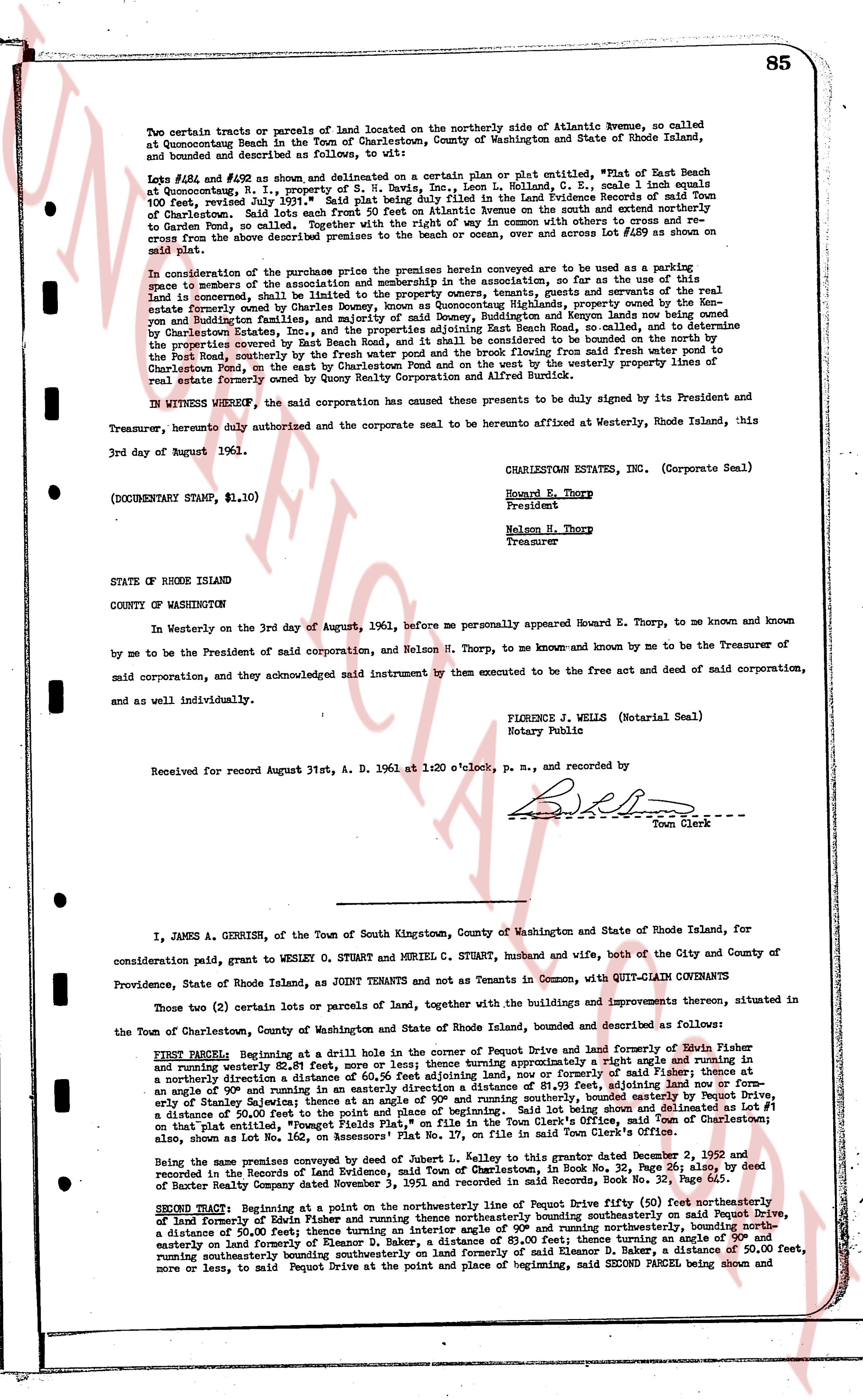
Two certain tracts or parcels of land located on the northerly side of Atlantic Avenue, so called Atlantic Avenue Beach in the Town of Charlestown, County of Washington and State of Rhode Island, bounded and described as follows:
Lots #184 and #192 as shown and delineated on a certain plan or plat entitled, "Plat of East Beach at Quonsetpoint, R. I., property of S. W. Davis, Inc." Leon L. Colland, C. E., scale 1 inch equals 100 feet dated July 1st, 1936, which plan is recorded in the Land Evidence Records of Charlestown, R. I. from Charlestown. Said lots each front 50 feet on Atlantic Avenue to the south and extend northerly to Garden Pond, so called. Together with the right to use the common ways or other access to said Garden Pond, and the right to use the common beach or ocean, over and across Lot #189 as shown on said plat.
In consideration of the purchase price the premises herein conveyed are to be used as a parking space for members of the association and the membership in the association, so for as the use of this land is concerned, shall lie and belong to the property owners in East Beach and several other properties especially those owned by the Charlestown Beach Association at Quonsetpoint, lands now owned by the Endicott and Ruddington Families, and majority of said Dones, Ruddington and Endicott lands now owned by Courtenay Charles Dexter, and the property of the Davis Beach, Inc., so called, the association determine the property covered by East Beach Road, and it shall be considered to be bounded on the north by the beach Pond, centrally by the property of the Davis Beach, Inc., so called, running from said front line of Atlantic Avenue to Charlestown Pond, on the east by Charlestown Pond and on the west by the westerly property lines of real estate formerly owned by Quocy Realty Corporation and Alfred Burtnik.
IN WITNESS WHEREOF, the said corporation has caused these presents to be duly signed by its President and Treasurer, hereunto duly authorized and the corporate seal to be hereunto affixed at Westerly, Rhode Island, Corporate Seal this 3rd day of August 1961.
CHARLESTOWN ESTATE, Inc. (Corporate Seal)
Howard E. Thorp
President
Nelson H. Thorp
Treasurer
(DOCUMENTARY STAMP, $1.10)
STATE OF RHODE ISLAND
COUNTY OF WASHINGTON
In Westerly on the 3rd day of August, 1961, before me personally appeared Howard E. Thorp, to me known and known by me to be the President of said corporation, and Nelson H. Thorp, to me known and known by me to be the Treasurer of said corporation, and they acknowledged said instrument by them executed to be the free act and deed of said corporation, and as an individually investing.
FIONA E. WELLS (Notarial Seal)
Notary Public
Received for record August 31st, A. D. 1961 at 1:20 o'clock, p. m., and recorded by
[Signature]
Town Clerk
----
I, JAMES A. GERRISH, of the Town of South Kingstown, County of Washington and State of Rhode Island, for consideration paid, grant to WESLEY O. STUART and MURIEL C. STUART, husband and wife, both of the City and County of Providence, State of Rhode Island, as JOINT TENANTS and not as Tenants in Common, with QUIT-CLAIM COVENANTS
Those two (2) certain lots or parcels of land, together with the buildings and improvements thereon, situated in the Town of Charlestown, County of Washington and State of Rhode Island, bounded and described as follows:
FIRST PARCEL Beginning at a drill hole in the corner of the property of Pequot Drive and land formerly of Silas Fisher and running easterly a distance 50.00 feet then turning an interior angle of a right angle and running in a northerly direction a distance of 50.56 feet adjoining land, now owned by former [?] Fisher then turning at an angle of 90 degrees and running easterly a distance of 50.00 feet adjoining land formerly of Silas Fisher then turning at an angle of 90 degrees and running southerly a distance of 50.56 feet adjoining land formerly of Silas Fisher then turning at an angle of 90 degrees and running westerly a distance of 50.00 feet to the point of beginning. Being a part of the property of Stanley Salzman; these limits at an angle of 90 degrees and running southerly, bounded easterly by Pequot Drive, a distance of 50.00 feet to the point of beginning. As shown on a certain plan entitled, "Quonset Flats Plan," on file in the Town Clerk's Office, Town of Charlestown; being a distance of 50.00 feet to the point of beginning. As shown on a certain plan entitled, "Quonset Flats Plan," on file in the Town Clerk's Office, Town of Charlestown. Being a part of Lot No. 162, on assessor's Plat No. 17, on file in the Town Clerk's office Charlestown.
Being the same premises conveyed by deed of James L. [?] and Silas Fisher grantor dated December 2, 1952 and recorded in the Records of the Land Evidence Office of Charlestown, in Book No. 32, Page 26, also, by deed of Baxter Realty Company dated November 3, 1953 and recorded in said Records, Book No. 34, Page 111.
SECOND TRACT: Beginning at a point on the northerly line of Pequot Drive fifty (50) feet northeasterly of land formerly of Ralph and [?] and running parallel with Pequot Drive northerly on said Pequot Drive, a distance of 50.00 feet; thence turning an interior angle of 90° and running northwesterly, bounding north easterly by land formerly of Ralph and [?] a distance of 50.00 feet; thence turning an interior angle of 90° and running northwesterly bounding southeasterly bounding southeasterly on land formerly of Samuel D. Baker, a distance of 50.00 feet, more or less, to said Pequot Drive at the point and place of beginning, said SECOND PARCEL being shown and
page 2 · read by Gemma vision
86
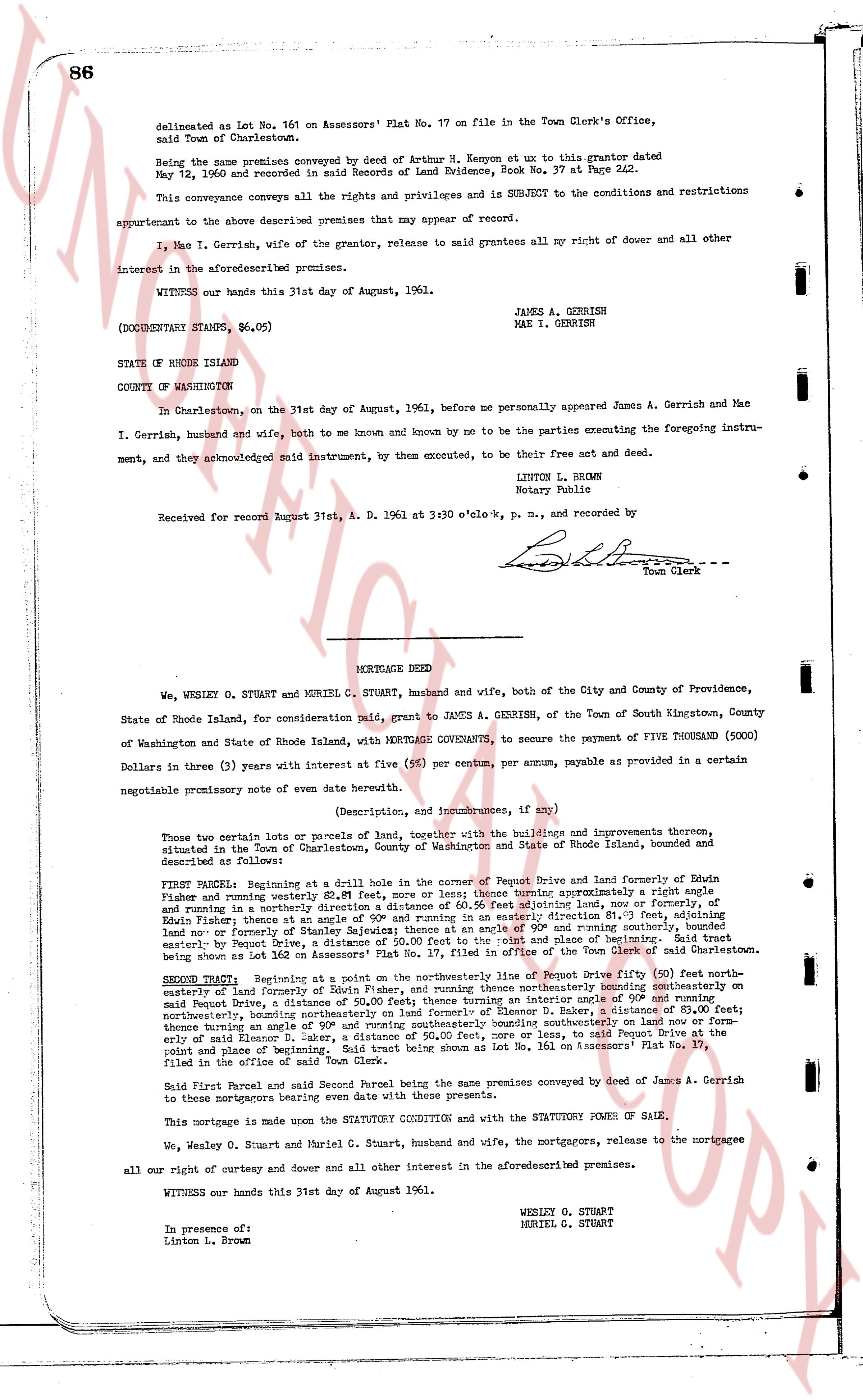
delineated as Lot No. 161 on Assessors' Plat No. 17 on file in the Town Clerk's Office, said Town of Charlestown.
Being the same premises conveyed by deed of Arthur H. Kenyon et ux to this grantor dated May 12, 1946 and recorded in said Records of Land Evidence Book No. 37 Page 242.
This conveyance conveys all the rights and privileges and is SUBJECT to the conditions and restrictions appurtenant to the above described premises as they appear of my record.
I, Mae I. Gerrish, wife of the grantor, release to said grantees all my right of dower and all other interest in the aforesaid premises.
WITNESS our hands this 31st day of August, 1961.
(DOCUMENTARY STAMPS, $6.05)
JAMES A. GERRISH
MAE I. GERRISH
STATE OF RHODE ISLAND
COUNTY OF WASHINGTON
In Charlestown, on the 31st day of August, 1961, before me personally appeared James A. Gerrish and Mae I. Gerrish, husband and wife, both to me known and by me to be the parties executing the foregoing instrument, and they acknowledged said instrument, by them executed, to be their free act and deed.
LINTON L. BROWN
Notary Public
Received for record August 31st, A. D. 1961 at 3:30 o'clock, p. m., and Recorded by
[Signature]
Town Clerk
----
MORTGAGE DEED
We, WESLEY O. STUART and MURIEL C. STUART, husband and wife, both of the City and County of Providence, State of Rhode Island, for consideration paid, grant to JAMES A. GERRISH, of the Town of South Kingstown, County of Washington and State of Rhode Island, with MORTGAGE COVENANTS, to secure the payment of FIVE THOUSAND (5000) Dollars in three (3) years with interest at five (5%) per centum, per annum, payable as provided in a certain negotiable promissory note of even date herewith.
(Description, and incumbrances, if any)
These two certain lots or parcels of land, together with the buildings and improvements thereon, situated in the Town of Charlestown, County of Washington and State of Rhode Island, known and described as follows:
FIRST PARCEL: Beginning at a drill hole in the corner of Peput Drive and land formerly of Edwin Fisher and running westerly 521.81 feet, more or less; thence turning north for approximately a right angle and running in a northerly direction 111.11 feet to a building land, now or formerly, of Edwin Fisher; thence at an angle of 90° and running in an easterly direction 81.35 feet, adjoining land now or formerly of the heirs of Edwin Fisher; thence at an angle of 90° and running southeasterly 107.50 feet, easterly by Peput Drive, being a distance of 50.00 feet to the "point and place" of beginning. Said tract being known as Lot No. 160 on Assessors' Plat No. 17 on file in the Town Clerk's Office.
SECOND PARCEL: Beginning at a point on the northeasterly line of Peput Drive fifty (50) feet northeasterly of the easterly boundary of Lot No. 160, and running northerly at an angle of 90° and running northeasterly on said Peput Drive, a distance of 50.00 feet, then running northeasterly bounding on southeasterly on thence turning an angle of 90° and running northeastly on former of Eleanor B. Baker, a distance of 80.00 feet, thence turning an angle of 90° and running southwesterly on said Eleanor B. Baker, a distance of 50.00 feet, more or less, to said Peput Drive at the point and place of beginning. Said tract being shown as Lot No. 161 on Assessors' Plat No. 17, filed in the office of the Town Clerk.
Said First Parcel and said Second Parcel being the same premises conveyed by deed of James A. Gerrish to these mortgagors bearing even date with these premises.
This mortgage is made under the STATUTORY CONDITION and with the STATUTORY POWER OF SALE.
We, Wesley O. Stuart and Muriel C. Stuart, husband and wife, the mortgagors, release to the mortgagee all our right of curtesy and dower and all other interest in the aforementioned premises.
WITNESS our hands this 31st day of August 1961.
WESLEY O. STUART
MURIEL C. STUART
In presence of:
Linton L. Brown
The page as recorded