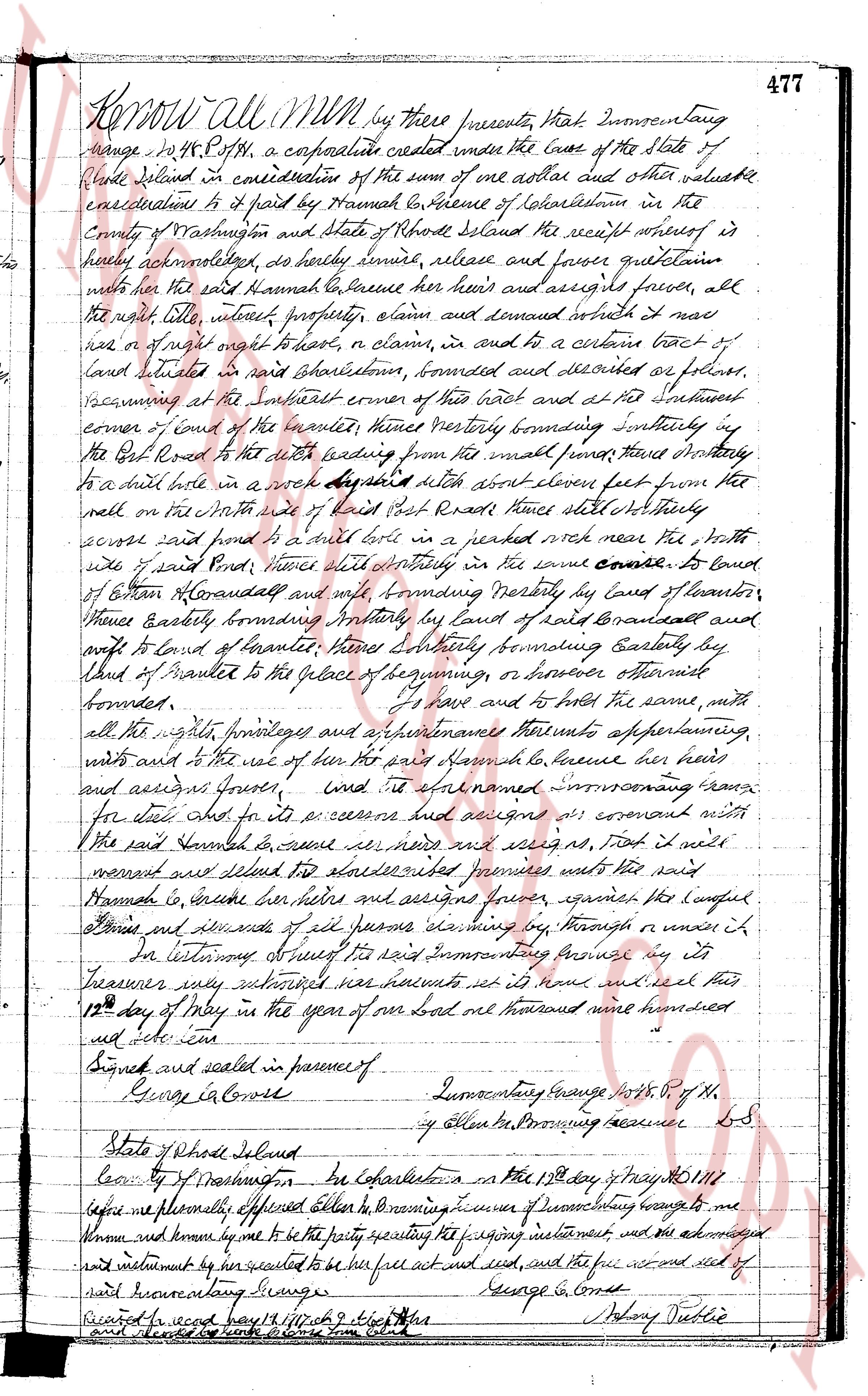
The instrument's own words
page 1
Know all men by these presents That Inmonentaug
Range No. 48 R. P. of the, a corporate created under the Laws of the State of
Rhode Island in consideration of the sum of one dollar and other valuable
considerations to it paid by Hannah Colverse of Colesttown in the
County of Washington and State of Rhode Island the receipt whereof is
hereby acknowledged, do hereby grant, release and forever quitclaim
unto the said Hannah Colverse her heirs and assigns forever, all
the right title, interest property, claim and demand which it now
has or of right ought to have, to a claim, in and to a certain tract of
land situated in said Northstown, bounded and described as follows,
beginning at the Southwest corner of this tract and at the Southwest
corner of land of the owner of the westmost fence westerly bordering southwesterly
the Post Road with a line leading east with the said road thence southeasterly
to a nail hole in a rock about 3 feet diameter about eleven feet from the
wall on the North side of said Post Road thence south Norththerly
across said pond to a nail hole in a peared rock near the North
side of said Post Road thence south easterly in the same course to land of
Ethan Brandell and walking boundary Northly by land of Ethan
Brandell bordering Northwesterly by land of Ethan
Brandell bordering Northwesterly by land of Brandell and
east to land of Brandell thence Easterly bounding Easterly by
land of Brandell to the place of beginning, or however otherwise
bounded.
To have and to hold the same, with
all the rights privileges and appurtenances thereunto appertaining,
unto and to the use of her the said Hannah Colverse her heirs
and assigns forever. And it covenants Inmonentaug Range
for its act and for its successors and covenant with
the said Hannah Colverse her heirs and assigns ns, That it will
warrant and defend the aforesaid premises unto the said
Hannah Colverse her heirs and assigns forever, against the lawful
claims and demands of all persons claiming by way or under it
In testimony whereof the said Inmonentaug Range by its
treasurer duly authorized has caused its name and seal to be affixed this
12th day of May in the year of our lord one thousand nine hundred
and sixteen.
Signed and sealed in presence of
George L. Conwell Inmonentaug Range No. 48 R. P. of the
By Allen Browning Treasurer L.S.
State of Rhode Island
County of Washington ss The 12th day of May No. 48 1916
before me personally appeared Allen Browning Treasurer of Inmonentaug Range to me
known and known by me to be the party executing the foregoing instrument and the acknowledged
and instrument by its sealated to be free act and deed, and the free act and deed of
said Inmonentaug Range.
George L. Conwell
Recorded 12 April 1917 Page 477
s.s. Johny Tuttle
The page as recorded