The instrument's own words
page 1
459
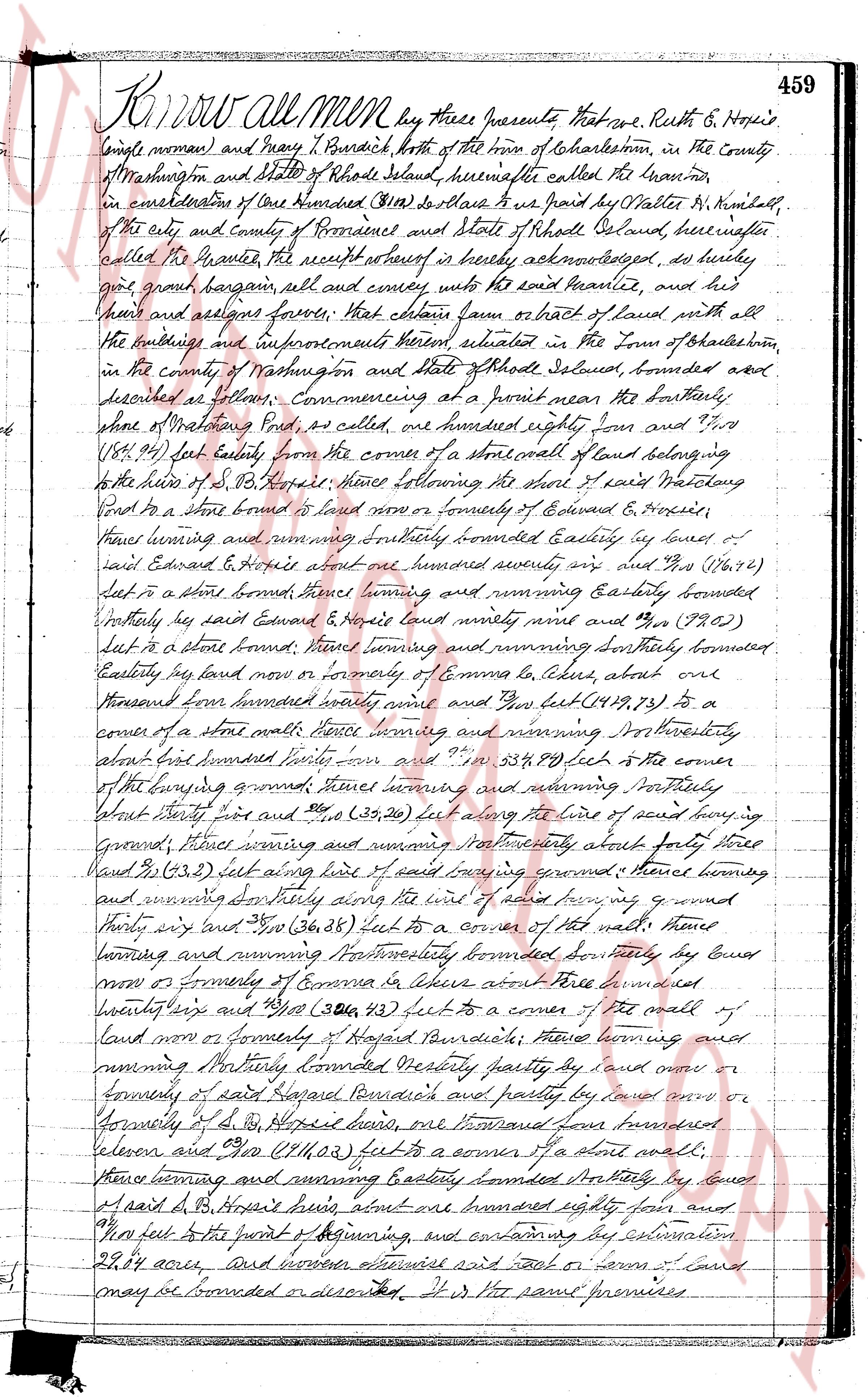
Know all Men by these presents that we, Ruth B. Hopkins
single woman and Mary T. Burdick both of the town of Charlestown, in the County
of Washington and state of Rhode Island, hereinafter called the Grantors
in consideration of Five Dollars ($5) to be paid by Walter H. Kimball,
of the city and County of Providence and state of Rhode Island, hereinafter
called the Grantee, the receipt whereof is hereby acknowledged, do hereby
give grant bargain assign all and convey unto the said Grantee and his
heirs and assigns forever, That certain farm or tract of land with all the
buildings and improvements thereon situated in the town of Charlestown,
in the county of Washington and state of Rhode Island, bounded and
described as follows: Commencing at a point near the southerly
shore of Watchung Pond, as called, and running easterly four hundred eighty four and 77/100
(484.77) feet easterly from the corner of a small lot of land belonging
to the heirs of d. B. Hopkins; thence following the shore of said Watchung
Pond to a stone bound is found now or formerly of Edward & Hopkins,
thence turning and running southerly bounded easterly by lands of
said Edward & Hopkins about one hundred seventy six and 74/100 (176.74)
feet to a stone bound thence turning and running easterly bounded
southerly by said Edward & Hopkins one hundred ninety nine and 31/100 (199.31)
feet to a stone bound; thence turning and running southerly bounded
easterly by land now or formerly of Connor et alscres, about one
thousand one hundred twenty seven and 23/100 (1127.23) to a
corner of a stone wall; thence turning and running nor westerly
about five hundred sixty four and 27/100 (564.27) feet to the corner
of the housing ground; thence turning and running northerly
about thirty five feet and 39/100 (35.39) feet along the line of said housing
ground; thence turning and running northwesterly about forty three
and 21/100 (43.21) feet along the line of said housing ground; thence turning
and running southeasterly along the line of said housing ground housing
thirty six and 29/100 (36.29) feet to a corner of a stone wall; thence
turning and running northwesterly bounded easterly by land
now or formerly of Connor et alscres about one thousand
twenty six and 38/100 (1026.38) feet to a corner of the wall of
land now or formerly of Hopkin Pawidice; thence turning and
running northerly bounded westerly partly by land now or
formerly of said Hopkin Pawidice and partly by land now or
formerly of d. B. Hopkins, one thousand one hundred
eleven and 05/100 (1111.05) feet to a corner of a stone wall;
thence turning and running easterly bounded northerly by land
of said d. B. Hopkins about one hundred eighty four and
00/100 feet to the point of beginning, and containing by estimation
29.84 acres; and however otherwise said lot or farm of land
may be bounded or described, it is the same premises.
page 2
460
hereinafter described in a certain Plat of land called "sand
and marshy Pond, situated in R.I. said my Ruth Hoxie and Henry
L. Hoxie to Martha N. Kimball, scit. 1" 200' mason 29, 1917.
It is planned, and conveyor to be deeded hereafter. It being understood
and agreed that the browsing ground on the southerly line of the plat
as at least a loggin of land it was conveyed by this deed.
To have and to hold the aforesaid premises, plot
all the premises and appurtenances thereto belonging, uniting
and to the use of the said grantee, and her heirs and assigns, forever.
And we the said grantors, do hereby for ourselves and for our heirs,
executors and administrators, covenant with the said grantee and
her heirs and assigns that we are lawfully seized in the simple estate of
the said premises, that the same are free from all encumbrances.
And we have good and right full power and lawful authority to sell
and convey the same in manner as aforesaid. That the said grantee and
her heirs and assigns shall by these premises at all times
quietly possess and quietly have and enjoy the said premises,
and that we the said grantors will, and our heirs, succeeding and
assigns shall warrant and defend the same to the said
grantee and her heirs and assigns forever against the lawful claims
and demands of all persons.
And for the consideration aforesaid I George Burdick, husband of the
said Mary L. Burdick do hereby release all my right of curtesy me
and to the said granted premises unto the said grantee and her
heirs and assigns forever.
In witness whereof we have hereunto set our hands and
seals this 31st day of April in the year of our Lord one thousand nine
hundred and seventeen.
Signed and sealed in presence of
George L. Coxes
Ruth B. Hoxie L.S.
Mary L. Burdick L.S.
George Burdick L.S.
State of Rhode Island
County of Washington.
On this afternoon on the 31st day of April AD 1917 before me
in Charlestown appeared Ruth B. Hoxie, Mary L. Burdick and George Burdick
personally known to me known and known by me to be the parties executing the foregoing
instrument and they acknowledged said instrument by them executed
to be their free act and deed.
George L. Coxes
Notary Public L.S.
received for record April 31 1917 at 4 o'clock P.M.
and recorded by George L. Coxes Town Clerk
page 3
461
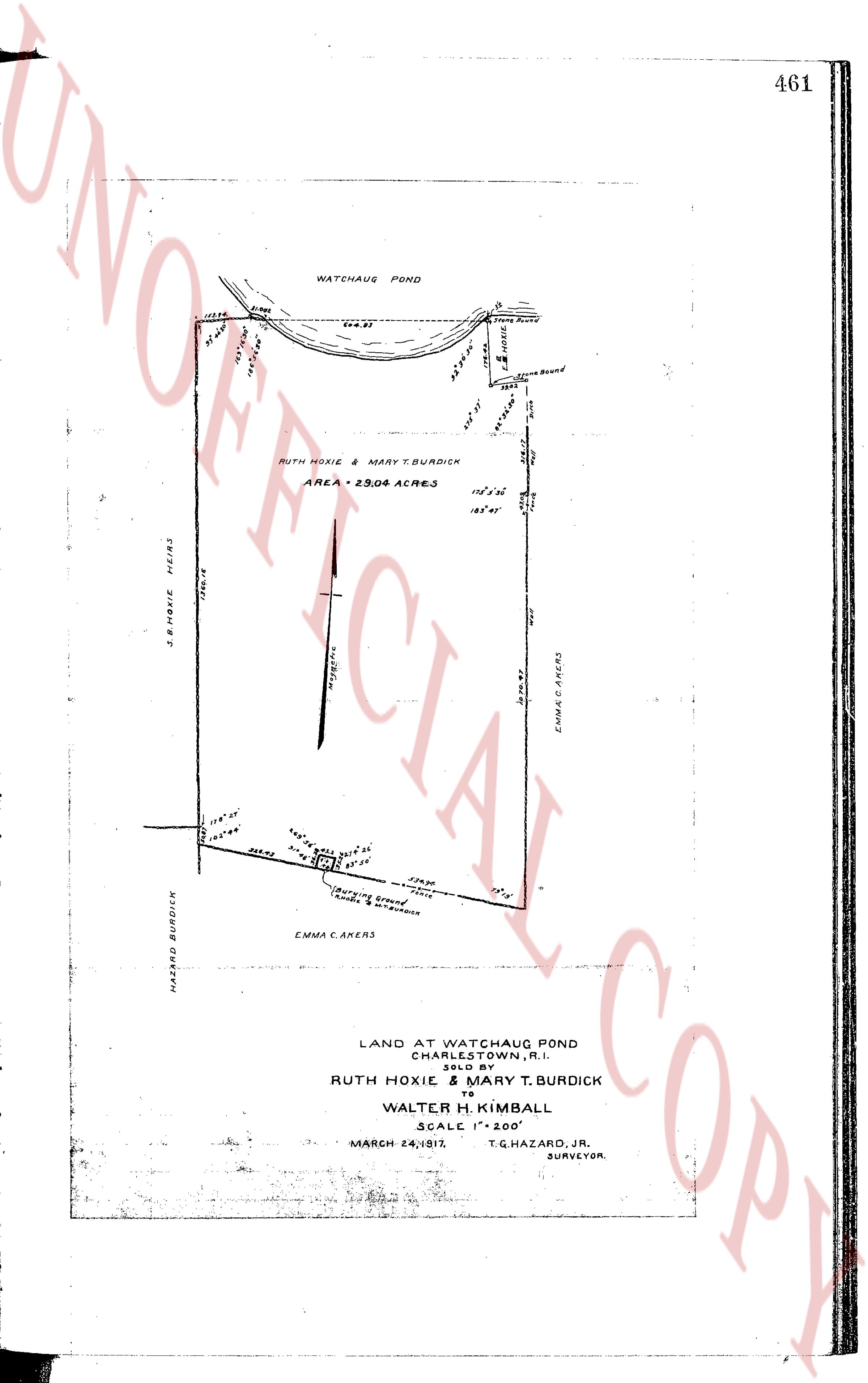
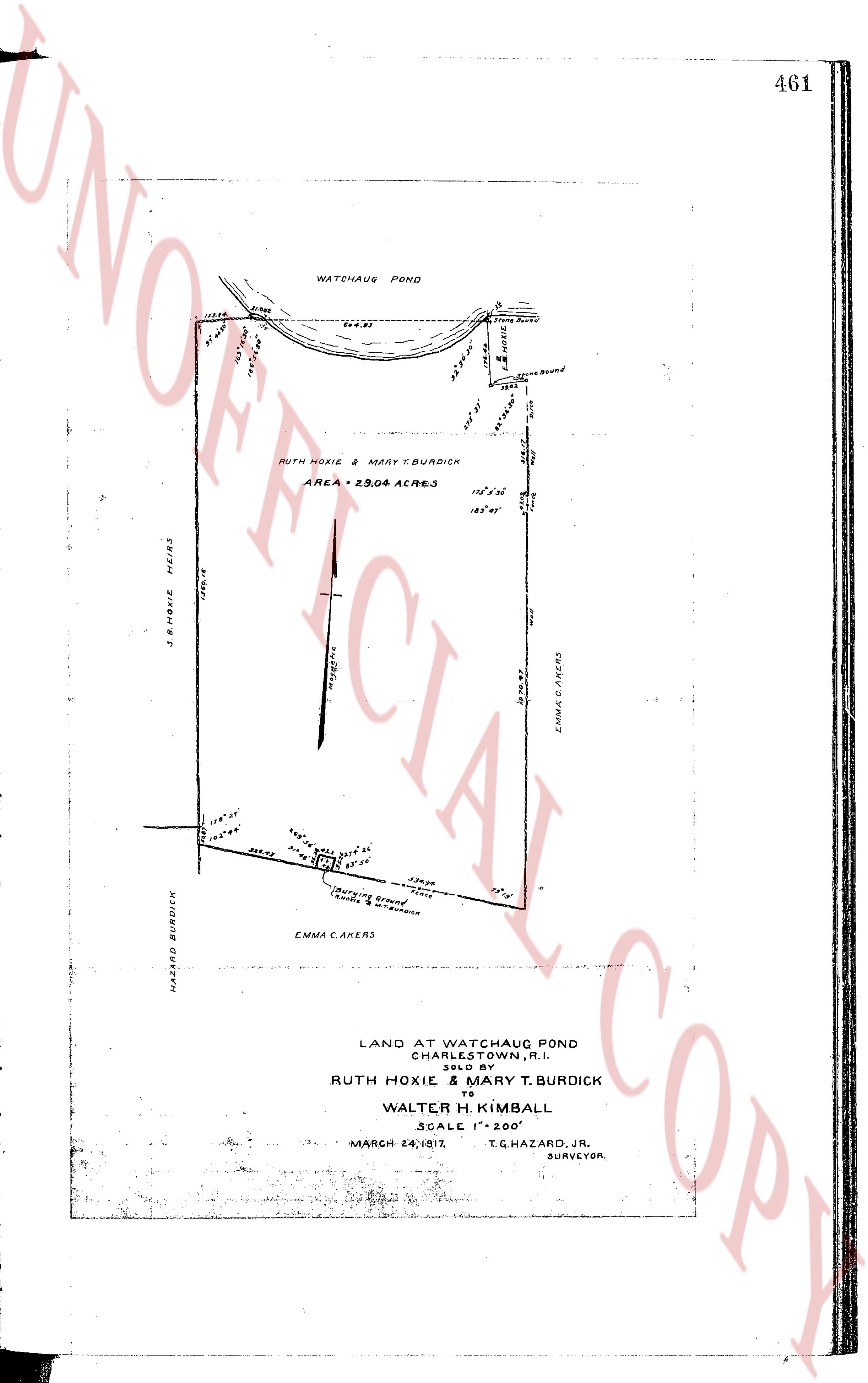
WATCHAUG POND
110.50
97.00
147.00
1280.14
S. B. HOXIE HEIRS
HAZARD BURDICK
13.8' 25"
13.8' 70"
0.46 RES.
60.5' 14"
30.1' 26"
23' 26"
(Burying Ground
Tomb & Enclosure)
EMMA C. AKERS
239.30
73' 15"
1070.93
EMMA C. AKERS
165' 45"
115' 5' 36"
RUTH HOXIE & MARY T. BURDICK
AREA = 29.06 ACRES
404.37
18.00
144.70
Stone Bound
Stone Bound
97.80
564.97
0.00
LAND AT WATCHAUG POND
CHARLESTOWN, R.I.
SOLD BY
RUTH HOXIE & MARY T. BURDICK
TO
WALTER H. KIMBALL
SCALE 1" = 200'
MARCH 24, 1917. T.G. HAZARD, JR.
SURVEYOR.
The page as recorded