The instrument's own words
page 1 · read by Gemma vision
51
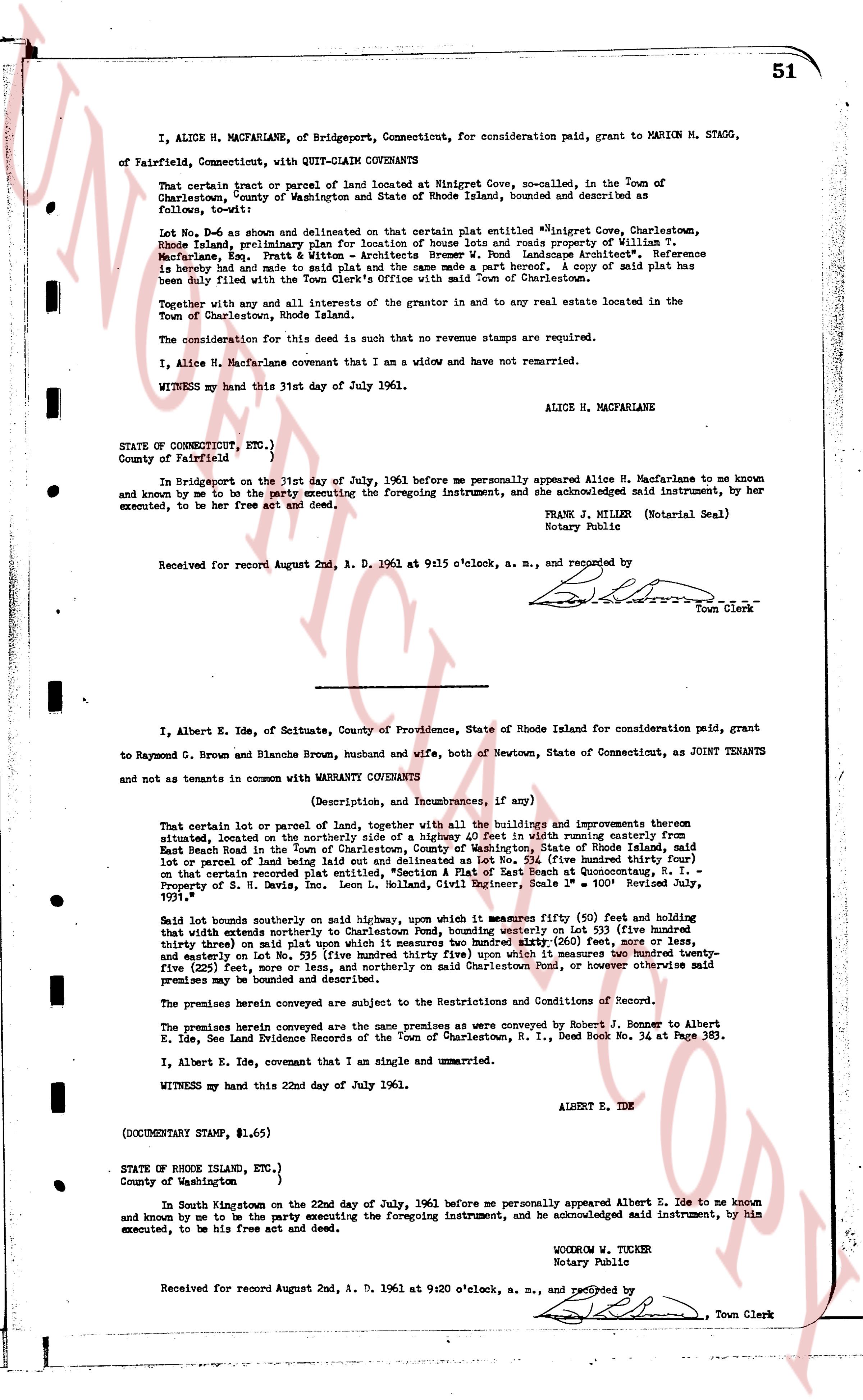
I, ALICE H. MACFARLANE, of Bridgeport, Connecticut, for consideration paid, grant to MARION M. STAGG, of Fairfield, Connecticut, with QUIT-CLAIM COVENANTS
That certain tract or parcel of land located at Ninigret Cove, no-called, in the Town of Charlestown, County of Washington, State of Rhode Island, bounded and described as follows, to-wit:
Lot No. 9, as shown and delineated on that certain plat entitled "Ninigret Cove, Charlestown, Rhode Island, preliminary plan for location of house lots and roads property of William T. Macfarlane, Eng. Pratt & Watson & Architects Brower W. Pond Landscape Architect." Reference is hereby made and save to said plat as a part hereof. A copy of said plat has been duly filed with the Town Clerk's Office with the Town of Charlestown.
Together with any and all interests of the grantor in and to any real estate located in the Town of Charlestown, Rhode Island.
The consideration for this deed is such that no revenue stamps are required.
I, Alice H. Macfarlane covenant that I am a widow and have not remarried.
WITNESS my hand this 31st day of July 1961.
ALICE H. MACFARLANE
STATE OF CONNECTICUT, ETC.)
County of Fairfield }
In Bridgeport on the 31st day of July, 1961 before me personally appeared Alice H. Macfarlane to me known and known to me to be the party executing the foregoing instrument, and she acknowledged said instrument, by her executed, to be her free act and deed.
FRANK J. MILLER (Notarial Seal)
Notary Public
Received for record August 2nd, A. D. 1961 at 9:15 o'clock, a. m., and recorded by [?] Town Clerk
----
I, Albert E. Ide, of Scituate, County of Providence, State of Rhode Island for consideration paid, grant to Raymond G. Brown and Blanche Brown, husband and wife, both of Newtown, State of Connecticut, as JOINT TENANTS and not as tenants in common with WARRANTY COVENANTS
(Description, and Incumbrances, if any)
That certain lot or parcel of land, together with all the buildings and improvements thereon situated, located on the northerly side of a highway 40 feet in width running easterly from East Beach Road in the town of Charlestown, County of Washington, State of Rhode Island as shown on that certain recorded plat entitled, "Section A Flat of East Beach at Quonutunga, R. I." Lot number 54 or parcel of land being lot number 54 on said plat, containing 0.34 (zero three hundred thirty four) lot or parcel of land being lot number 54 on said plat, containing 0.34 (zero three hundred thirty four) lot or parcel of land being lot number 54 on said plat, containing 0.34 (zero three hundred thirty four) lot or parcel of land being lot number 54 on said plat, containing 0.34 (zero three hundred thirty four) lot or parcel of land being lot number 54 on said plat, containing 0.34 (zero three hundred thirty four) lot or parcel of land being lot number 54 on said plat, containing 0.34 (zero three hundred thirty four) lot or parcel of land being lot number 54 on said plat, containing 0.34 (zero three hundred thirty four) lot or parcel of land being lot number 54 on said plat, containing 0.34 (zero three hundred thirty four) lot or parcel of land being lot number 54 on said plat, containing 0.34 (zero three hundred thirty four) lot or parcel of land being lot number 54 on said plat, containing 0.34 (zero three hundred thirty four) lot or parcel of land being lot number 54 on said plat, containing 0.34 (zero three hundred thirty four) lot or parcel of land being lot number 54 on said plat, containing 0.34 (zero three hundred thirty four) lot or parcel of land being lot number 54 on said plat, containing 0.34 (zero three hundred thirty four) lot or parcel of land being lot number 54 on said plat, containing 0.34 (zero three hundred thirty four) lot or parcel of land being lot number 54 on said plat, containing 0.34 (zero three hundred thirty four) lot or parcel of land being lot number 54 on said plat, containing 0.34 (zero three hundred thirty four) lot or parcel of land being lot number 54 on said plat, containing 0.34 (zero three hundred thirty four) lot or parcel of land being lot number 54 on said plat, containing 0.34 (zero three hundred thirty four) lot or parcel of land being lot number 54 on said plat, containing 0.34 (zero three hundred thirty four) lot or parcel of land being lot number 54 on said plat, containing 0.34 (zero three hundred thirty four) lot or parcel of land being lot number 54 on said plat, containing 0.34 (zero three hundred thirty four) lot or parcel of land being lot number 54 on said plat, containing 0.34 (zero three hundred thirty four) lot or parcel of land being lot number 54 on said plat, containing 0.34 (zero three hundred thirty four) lot or parcel of land being lot number 54 on said plat, containing 0.34 (zero three hundred thirty four) lot or parcel of land being lot number 54 on said plat, containing 0.34 (zero three hundred thirty four) lot or parcel of land being lot number 54 on said plat, containing 0.34 (zero three hundred thirty four) lot or parcel of land being lot number 54 on said plat, containing 0.34 (zero three hundred thirty four) lot or parcel of land being lot number 54 on said plat, containing 0.34 (zero three hundred thirty four) lot or parcel of land being lot number 54 on said plat, containing 0.34 (zero three hundred thirty four) lot or parcel of land being lot number 54 on said plat, containing 0.34 (zero three hundred thirty four) lot or parcel of land being lot number 54 on said plat, containing 0.34 (zero three hundred thirty four) lot or parcel of land being lot number 54 on said plat, containing 0.34 (zero three hundred thirty four) lot or parcel of land being lot number 54 on said plat, containing 0.34 (zero three hundred thirty four) lot or parcel of land being lot number 54 on said plat, containing 0.34 (zero three hundred thirty four) lot or parcel of land being lot number 54 on said plat, containing 0.34 (zero three hundred thirty four) lot or parcel of land being lot number 54 on said plat, containing 0.34 (zero three hundred thirty four) lot or parcel of land being lot number 54 on said plat, containing 0.34 (zero three hundred thirty four) lot or parcel of land being lot number 54 on said plat, containing 0.34 (zero three hundred thirty four) lot or parcel of land being lot number 54 on said plat, containing 0.34 (zero three hundred thirty four) lot or parcel of land being lot number 54 on said plat, containing 0.34 (zero three hundred thirty four) lot or parcel of land being lot number 54 on said plat, containing 0.34 (zero three hundred thirty four) lot or parcel of land being lot number 54 on said plat, containing 0.34 (zero three hundred thirty four) lot or parcel of land being lot number 54 on said plat, containing 0.34 (zero three hundred thirty four) lot or parcel of land being lot number 54 on said plat, containing 0.34 (zero three hundred thirty four) lot or parcel of land being lot number 54 on said plat, containing 0.34 (zero three hundred thirty four) lot or parcel of land being lot number 54 on said plat, containing 0.34 (zero three hundred thirty four) lot or parcel of land being lot number 54 on said plat, containing 0.34 (zero three hundred thirty four) lot or parcel of land being lot number 54 on said plat, containing 0.34 (zero three hundred thirty four) lot or parcel of land being lot number 54 on said plat, containing 0.34 (zero three hundred thirty four) lot or parcel of land being lot number 54 on said plat, containing 0.34 (zero three hundred thirty four) lot or parcel of land being lot number 54 on said plat, containing 0.34 (zero three hundred thirty four) lot or parcel of land being lot number 54 on said plat, containing 0.34 (zero three hundred thirty four) lot or parcel of land being lot number 54 on said plat, containing 0.34 (zero three hundred thirty four) lot or parcel of land being lot number 54 on said plat, containing 0.34 (zero three hundred thirty four) lot or parcel of land being lot number 54 on said plat, containing 0.34 (zero three hundred thirty four) lot or parcel of land being lot number 54 on said plat, containing 0.34 (zero three hundred thirty four) lot or parcel of land being lot number 54 on said plat, containing 0.34 (zero three hundred thirty four) lot or parcel of land being lot number 54 on said plat, containing 0.34 (zero three hundred thirty four) lot or parcel of land being lot number 54 on said plat, containing 0.34 (zero three hundred thirty four) lot or parcel of land being lot number 54 on said plat, containing 0.34 (zero three hundred thirty four) lot or parcel of land being lot number 54 on said plat, containing 0.34 (zero three hundred thirty four) lot or parcel of land being lot number 54 on said plat, containing 0.34 (zero three hundred thirty four) lot or parcel of land being lot number 54 on said plat, containing 0.34 (zero three hundred thirty four) lot or parcel of land being lot number 54 on said plat, containing 0.34 (zero three hundred thirty four) lot or parcel of land being lot number 54 on said plat, containing 0.34 (zero three hundred thirty four) lot or parcel of land being lot number 54 on said plat, containing 0.34 (zero three hundred thirty four) lot or parcel of land being lot number 54 on said plat, containing 0.34 (zero three hundred thirty four) lot or parcel of land being lot number 54 on said plat, containing 0.34 (zero three hundred thirty four) lot or parcel of land being lot number 54 on said plat, containing 0.34 (zero three hundred thirty four) lot or parcel of land being lot number 54 on said plat, containing 0.34 (zero three hundred thirty four) lot or parcel of land being lot number 54 on said plat, containing 0.34 (zero three hundred thirty four) lot or parcel of land being lot number 54 on said plat, containing 0.34 (zero three hundred thirty four) lot or parcel of land being lot number 54 on said plat, containing 0.34 (zero three hundred thirty four) lot or parcel of land being lot number 54 on said plat, containing 0.34 (zero three hundred thirty four) lot or parcel of land being lot number 54 on said plat, containing 0.34 (zero three hundred thirty four) lot or parcel of land being lot number 54 on said plat, containing 0.34 (zero three hundred thirty four) lot or parcel of land being lot number 54 on said plat, containing 0.34 (zero three hundred thirty four) lot or parcel of land being lot number 54 on said plat, containing 0.34 (zero three hundred thirty four) lot or parcel of land being lot number 54 on said plat, containing 0.34 (zero three hundred thirty four) lot or parcel of land being lot number 54 on said plat, containing 0.34 (zero three hundred thirty four) lot or parcel of land being lot number 54 on said plat, containing 0.34 (zero three hundred thirty four) lot or parcel of land being lot number 54 on said plat, containing 0.34 (zero three hundred thirty four) lot or parcel of land being lot number 54 on said plat, containing 0.34 (zero three hundred thirty four) lot or parcel of land being lot number 54 on said plat, containing 0.34 (zero three hundred thirty four) lot or parcel of land being lot number 54 on said plat, containing 0.34 (zero three hundred thirty four) lot or parcel of land being lot number 54 on said plat, containing 0.34 (zero three hundred thirty four) lot or parcel of land being lot number 54 on said plat, containing 0.34
The page as recorded