The instrument's own words
page 1
353
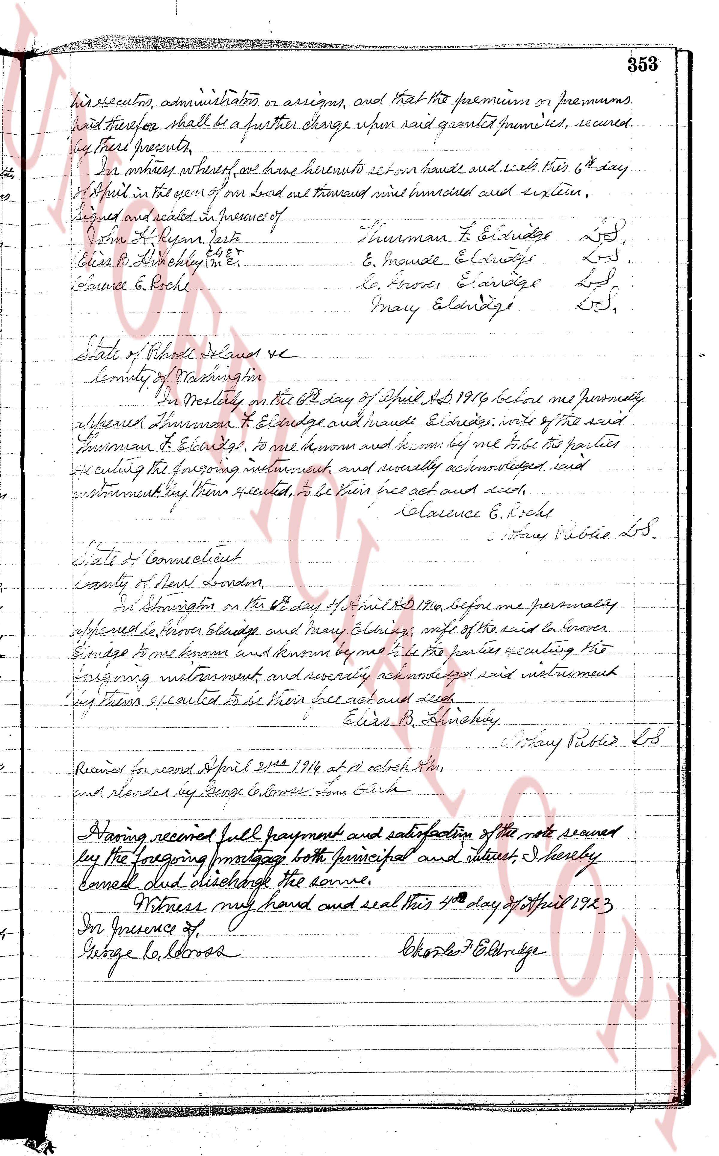
his executors, administrators, or assigns, and that the premium or premiums
paid therefore shall be a further charge upon said granted premises, secured
by these presents.
For witness whereof, we have hereunto set our hands and seals this 6th day
of April in the year of our Lord one thousand eight hundred and sixteen.
Signed and sealed in presence of
John H. Dyer just
Elias B. Lathrop Enr
Clarence E. Roche
Truman F. Eldridge L S.
E. Maude Eldridge L S.
L. S.rover E. Eldridge L S.
Mary Eldridge L S.
State of Rhode Island sc
County of Providence
In Westerly on the 6th day of April AD 1816 before me personally
appeared Truman F. Eldridge and Maude Eldridge, wife of the said
Truman F. Eldridge, to me known and known by me to be the parties
executing the foregoing instrument and severally acknowledged said instrument
before me to be their free act and deed.
Clarence E. Roche
Mary Rubies L S.
State of Connecticut
County of New London
In Stonington on the 6th day of April AD 1816 before me personally
appeared Truman Eldridge and Mary Eldridge, wife of the said Truman
Eldridge to me known and known by me to be the parties executing the
foregoing instrument and severally acknowledged said instrument
before me to be their free act and deed.
Elias B. Lathrop
Mary Rubies L S.
Received for record April 21st 1816 at 10 o'clock AM
and recorded by George Co. Lorna Town Clerk
Having received full payment and satisfaction of the note secured
by the foregoing mortgage both principal and interest I hereby
cancel and discharge the same.
Witness my hand and seal this 4th day of April 1923
In presence of
George Co Lorna
Charles F Eldridge
page 2
13
of 150.00 feet to an iron pipe; thence turning an interior angle of 90° 00' and running southerly a
distance of 85.00 feet to an iron pipe; thence turning an interior angle of 90° 00' and running easterly a
distance of 125.00 feet to an iron pipe; thence running along the easterly westerly line of Meadow Lane; thence
turning an interior angle of 90° 00' and running northerly and by the westerly line of Meadow
Lane a distance of 85.00 feet to the point and place of beginning.
The above described premises being then shown and delineated on Lot Number 26 (twenty-six) that certain
plat marked "Plat of Section 14, Town of Charlestown, R.I., Scale 1 inch = 50 feet Sept. 7,
1959 H. A. Emerson, Civil Engr" m.s., on file in the Office of the Town Clerk of said Town of Charlestown.
Reference is made to that being more hereby made and for a more detailed and particular description of the
premises herein conveyed.
Meaning and intending to convey the same premises described in deed of W. Monroe Hossie ex ut us
Grantors; said deed being date of September 19th, 1959 and recorded in the Records of Land Evidence, said
Town of Charlestown, Book No. 37, Pages 39 and 40.
We, John E. Truesdale and Dorothy E. Truesdale, husband and wife, release to said Grantees all our
right of curtesy and dower, respectively, and all other interest in the aforementioned premises.
WITNESS our hands this 10th day of July, 1961.
(Documentary stamps $1.10)
JOHN E. TRUESDALE
DOROTHY E. TRUESDALE
STATE OF RHODE ISLAND
COUNTY OF WASHINGTON
In Charlestown on the 10th day of July, 1961, before me personally appeared John E. Truesdale and
Dorothy E. Truesdale, husband and wife, both to me known and by me to be the parties executing the
foregoing instrument, and they acknowledged said instrument, by them executed, to be their free act and deed.
LINTON L. BROWN LS
Notary Public
Received for record July 10th A.D. 1961 at 1:50 o'clock P.M and recorded by Jean M. Clarke
Deputy Town Clerk
STATUTORY FORM OF WARRANTY DEED
We, John E. Woodmansee, Jr. and Virginia R. Woodmansee, husband and wife, both of the Town of Charlestown,
State of Rhode Island, for consideration paid, grant to John E. Woodmansee and Frances M. Woodmansee, husband
and wife, both of the Town of Charlestown, County of Washington and State of Rhode Island, as JOINT TENANTS
and not as Tenants in Common, with WARRANTY CONVEYANTS
That certain parcel or tract of land together with the buildings and improvements thereon, situated in
the Town of Charlestown, County of Washington, State of Rhode Island, bounded and described as follows:
Beginning at a point mark running the northeasterly corner of the tract thereby converging on the southerly
boundary line of Farm Rd. from the point of beginning; thence running southerly a distance of 120 feet westerly from the
State Highway thence at right angles with said boundary line and running southerly a distance of
100 feet to a point thence turning an interior angle of 90° 00' and running easterly a distance of 125 feet to a
point; thence at right angles and running northerly a distance of 82 feet to the southerly boundary
line of said Raymond's Farm Rd. thence turning an interior angle northerly by and diverging north by an
distance of 100 feet to the point and place of beginning.
Being the same name premises conveyed by the deed of these Grantees to these Grantors dated March 1961
and recorded in the Records of Land Evidence, said Town of Charlestown, in Book No. 37 at Page 448.
We, John E. Woodmansee, Jr. and Virginia R. Woodmansee, husband and wife, the grantors release to
said grantees all our right of curtesy and dower and all other interest in the aforementioned premises.
WITNESS our hands this 10th day of July 1961.
JOHN E. WOODMANSEE, JR.
VIRGINIA R. WOODMANSEE
STATE OF RHODE ISLAND, ETC.)
COUNTY OF WASHINGTON
In Charlestown on the 10th day of July 1961 before me personally appeared John E. Woodmansee, Jr. and
Virginia R. Woodmansee, husband and wife, both to me known and by me to be the parties executing the
foregoing instrument, and they severally acknowledged said instrument, by them executed, to be their free
act and deed.
LINTON L. BROWN LS
Notary Public
Received for record July 10th A.D. 1961 at 2:10 o'clock P.M. and recorded by Jean M. Clarke
Deputy Town Clerk
The page as recorded