The instrument's own words
page 1 · read by Gemma vision
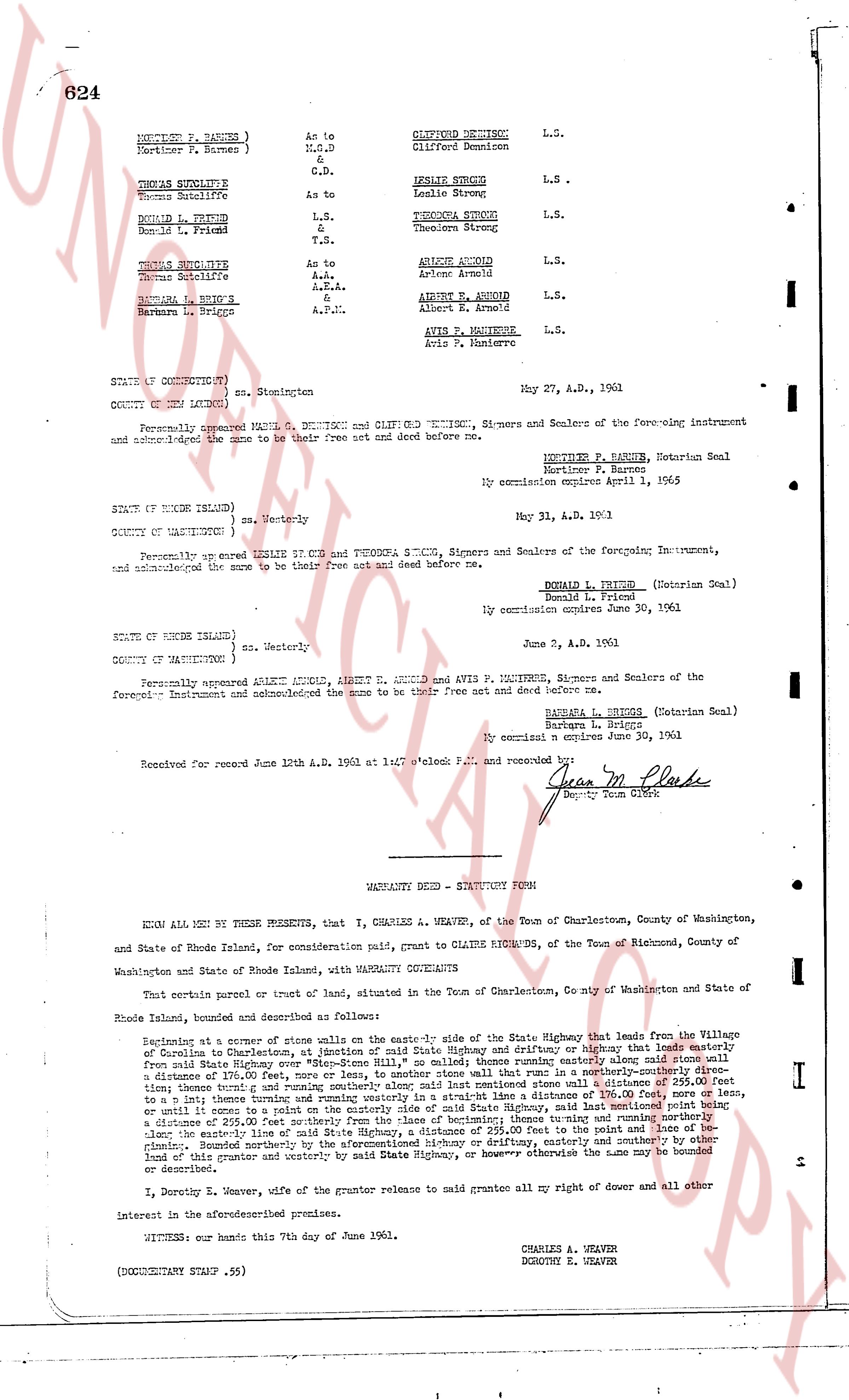
624
HERBERT F. BARNES ) As to
Mortimer F. Barnes ) M.G.D.
&
G.D.
THOMAS SULLIVAN
Thomas Sullivan As to
DONALD L. FRIEND L.S.
Donald L. Friend & T.S.
THOMAS SULLIVAN
Thomas Sullivan As to
A.P.
A.P.
A.P.I.
BARBARA L. BRIGGS
Barbara L. Briggs
CLIFFORD DENISON L.S.
Clifford Denison
LESLIE STRONG L.S.
Leslie Strong
THEODORA STRONG L.S.
Theodora Strong
ARLENE ARCOUD L.S.
Arlene Arcoud
ALBERT E. ARCOUD L.S.
Albert E. Arcoud
AVIS P. MAUTIERE L.S.
Avis P. Mautiere
STATE OF CONNECTICUT )
COUNTY OF NEW LONDON ) ss. Stonington
May 27, A.D. 1961
Personally appeared MARK DENISON and CLIFFORD DENISON, Signers and Sealers of the foregoing instrument and acknowledged the same to be their free act and deed before me.
HERBERT F. BARNES, Notarian Seal
Mortimer F. Barnes
My commission expires April 1, 1965
STATE OF RHODE ISLAND )
COUNTY OF WASHINGTON ) ss. Westerly
May 31, A.D. 1961
Personally appeared LESLIE STRONG and THEODORA STRONG, Signers and Sealers of the foregoing Instrument, and acknowledged the same to be their free act and deed before me.
DONALD L. FRIEND (Notarian Seal)
Donald L. Friend
My commission expires June 30, 1961
STATE OF RHODE ISLAND )
COUNTY OF WASHINGTON ) ss. Westerly
June 2, A.D. 1961
Personally appeared ARLENE ARCOUD, ALBERT E. ARCOUD and AVIS P. MAUTIERE, Signers and Sealers of the foregoing Instrument and acknowledged the same to be their free act and deed before me.
BARBARA L. BRIGGS (Notarian Seal)
Barbara L. Briggs
My commission expires June 30, 1961
Received for record June 12th A.D. 1961 at 1:47 o'clock P.M. and recorded by:
Jean M. Plunks
Deputy Town Clerk
----
WARRANTY DEED - STATUTORY FORM
KNOW ALL MEN BY THESE PRESENTS, that I, CHARLES A. WEAVER, of the Town of Charlestown, County of Washington, and State of Rhode Island, for consideration paid, grant to CLAIRE RICHARDS, of the Town of Richmond, County of Washington and State of Rhode Island, with WARRANTY CONVEYANCE
That certain parcel or tract of land, situated in the Town of Charlestown, County of Washington and State of Rhode Island, bounded and described as follows:
Beginning at a corner of stone walls on the easterly side of the State Highway that leads from the Village of Charlestown to Coventry, at Charlestown, of said State Highway and driftway or highway that leads westerly from said State Highway over land now owned by "M.A. HILL" and sailed; thence running easterly along said stone wall from said State Highway over land now owned by "M.A. HILL" to a stone wall that runs in a northerly-southerly direction to a distance of 176.00 feet, more or less, to another stone wall that runs in a northerly-southerly direction to a distance of 110.00 feet, more or less, to a stone wall that runs in an easterly direction to a distance of 110.00 feet, more or less, to a line running westerly and turning running westerly in a straight line to a distance of 176.00 feet, more or less, to an east wall that runs in a southerly direction to a distance of 110.00 feet, more or less, to a line running easterly to a distance of 110.00 feet, more or less, to a stone wall that runs in a northerly direction to a distance of 225.00 feet northerly from the base of declivity, thence turning and running northerly along said wall to a distance of 110.00 feet, more or less, to the point of beginning; bounded northerly by the aforementioned highway or driftway, easterly and southerly by other land of this grantor and westerly by said State Highway, or however otherwise the same may be bounded or described.
I, Dorothy E. Weaver, wife of the grantor release to grantee release to grant all my dower and all other interest in the aforementioned premises.
WITNESS: our hands this 7th day of June 1961.
CHARLES A. WEAVER
DOROTHY E. WEAVER
(DOCUMENTARY STAMP .55)
page 2 · read by Gemma vision
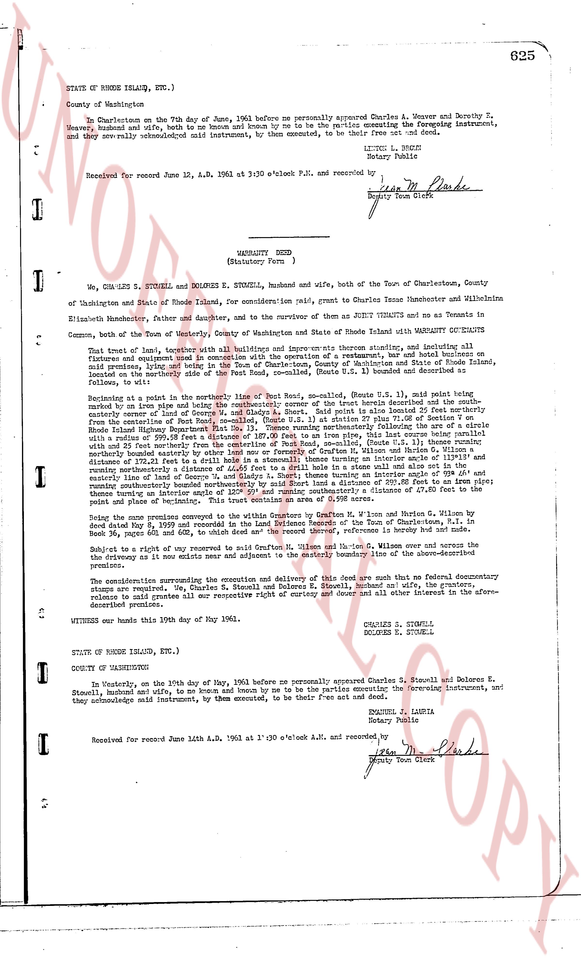
STATE OF RHODE ISLAND, ETC.)
County of Washington
In Charlestown on the 7th day of June, 1961 before me personally appeared Charles A. Weaver and Dorothy E. Weaver, husband and wife, both to me known and by me known to be the parties executing the foregoing instrument, and they sew acknowledged said instrument, by them executed, to be their free act and deed.
LITTEN L. BRUZZI
Notary Public
Received for record June 12, A.D. 1961 at 3:30 o'clock P.M. and recorded by
[Signature]
Deputy Town Clerk
----
WARRANTY DEED
(Statutory Form)
I, We, CHARLES S. STOWELL and DOLORES E. STOWELL, husband and wife, both of the Town of Charlestown, County of Washington and State of Rhode Island, for consideration paid, grant to Charles Jesse Hunchemaster and Wilhelnina Elizabeth Hunchemaster, father and daughter, and to the survivor of them as JOINT TENANTS and no as Tenants in Common, both of the Town of Westerly, County of Washington and State of Rhode Island with WARRANTY COVENANTS that trust of land, together with all buildings and improvements thereon situated, and including all fixtures and equipment used in connection with the operation of a restaurant, inn and other businesses on said premises, lying and being in the Town of Charlestown, County of Washington and State of Rhode Island, located on the northeasterly side of the Post Road, se-called, (Route U.S. 1) bounded and described as follows, to wit:
Beginning at a point in the northerly line of Post Road, se-called, (Route U.S. 1) said point being east of the pine slope of and being the northeasterly corner of the tract herein described and the southeasterly corner of land now owned by [?] and located 25 1/2 feet south 61.08 GE of Section 7 on the easterly corner of land of Post Road, se-called, (Route U.S. 1) at station 27 plus 51.08 GE of Section 7 on Rhode Island Highway Department Plat No. 11, (Sheet 1) thence running southeasterly following the line of the [?] with 25 feet northerly easterly corner of land of [?] for a distance of 187.00 feet to an iron pipe, this line course being parallel with a course of 29.25 DE south 45.11 east from the centerline of Post Road, se-called, (Route U.S. 1) thence running southeasterly a distance of 115.00 feet to an iron pipe, this line being the boundary between the land of the grantors and the land of Grafton M. Wilson and Garion G. Wilson a distance of 172.21 feet to a drill hole set in a stonewall thence turning an interior angle of 105 30 AE and running southeasterly a distance of 115.00 feet to an iron pipe, this line being the east wall and also the northeasterly boundary of a distance of 100 feet to a stonewall thence turning an interior angle of 108 40 AE and running easterly a distance of 100 feet to a stonewall thence turning an interior angle of 120 00 AE and running northwesterly a distance of 178.00 feet to an iron pipe, this line being the boundary between the land of the grantors and the land of Grafton M. Wilson and Garion G. Wilson once more turning an interior angle of 120 00 AE and thence running southeasterly a distance of 47.50 feet to the point and place of beginning.
Being the same premises conveyed to the writers as Tenants by Grafton M. Wilson and Garion G. Wilson over and across the deed dated May 8, 1959 and recorded in the Land Evidence Records of the Town of Charlestown, R.I. in Book 36, pages 602 and 603, and the reference is hereby made thereto.
Subject to a right of way for ingress and egress reserved to Grafton M. Wilson and Garion G. Wilson over and across the premises at or at a line exists near and adjacent to the easterly boundary line of the above-described premises.
The considerations surrounding the execution and delivery of this deed are such that no formal documentary stamps are required. We, Charles S. Stowell and Dolores E. Stowell, husband and wife, the grantors, release to said grantees all our respective right of curtesy and dower and all other interest in the afore-described premises.
In witness whereof we have hereunto set our hands this 10th day of May 1961.
CHARLES S. STOWELL
DOLORES E. STOWELL
STATE OF RHODE ISLAND, ETC.)
COUNTY OF WASHINGTON
In Westerly, on the 10th day of May, 1961 before me personally appeared Charles S. Stowell and Dolores E. Stowell, husband and wife, to me known and by me known to be the parties executing the foregoing instrument, and they acknowledge said instrument, by them executed, to be their free act and deed.
EMMANUEL J. LAURIA
Notary Public
Received for record June 14th A.D. 1961 at 1:30 o'clock A.M. and recorded by
[Signature]
Deputy Town Clerk
The page as recorded