The instrument's own words
Attribution under review. The portal's file number is shared by more than one instrument, and the words below could not be placed with certainty on this one by their own evidence (page stamp, parties, dates); they may belong to a neighbouring instrument. Read them as the record of the page, not yet as this deed's own.
page 1
261
KNOW ALL MEN BY THESE PRESENTS, that We, GRAPHTON M. WILSON and MARION G. WILSON,
both of the Town of Charlestown, County of Washington, in the State of Rhode Island, herein-
after called the Grantors, for and in consideration of the sum of TEN and 00/100 ($10.00)
Dollars to us paid by O. LEONARD WRIGHT and MURIEL WRIGHT, husband and wife, both of the
City of Cranston, County of Providence, in the State of Rhode Island, hereinafter called the
Grantees, the receipt whereof is hereby acknowledged, do hereby give, grant, bargain, sell
and convey unto the said Grantees, as joint tenants and not as tenants in common, and their
heirs and assigns forever, in fee simple
That certain real estate situate in the Town of Charlestown, County
of Washington, State of Rhode Island, and described as follows:
Commencing at a stone post located at the northeasterly corner of land
now or lately of Albert G. and his heirs or assigns of a straight line right
of way thence running in a southeasterly direction two hundred ten feet
and ninety-eight hundredths (210.98) feet to a stone post set in a stone bound;
thence continuing in the same straight line eighteen (18) feet; thence south-
easterly forty-three feet and twenty-four hundredths (43.24) feet to a stone bound;
thence running in a northeasterly direction following the centerline of Water line of Charlestown Pond;
thence running in a northeasterly direction following the southeasterly line of land
now or lately of Elizabeth Hanford; until it intersects the southerlyline of land of
late of George B. Moore; thence continuing in the same running in a northeasterly
direction seventy-seven feet and twenty-four hundredths (77.24) feet to a stone bound;
thence continuing in the same straight line one hundred ninety-one feet and thirty-nine
one-hundredths (191.39) feet to a stone post set in the water; thence running in a south-
westerly direction eighty-five feet and twenty-four hundredths (85.24) feet to a stone post
at the way now or lately of the northeasterly corner of the hereby conveyed tract, said last
mentioned point being the same point which marks the northeasterly corner of land of
L. Sisson now and or lately of Elizabeth Hanford; thence running and running in
a southeasterly direction seventy-seven feet and twenty-four hundredths (77.24) feet to a stone post in
the southeasterly corner of land conveyed to Samuel S. Greene and Albert B.
Perry by George B. Moore by a deed dated June 1, 1921, recorded in the volume of
land Evidence recorded in Clerk's Recordbook in Plat index in books 449 and pages 441-442;
thence continuing in the same straight line one hundred ninety-one feet and thirty-nine
one-hundredths (191.39) feet to a stone post set in the water; thence running in a north-
(55.15)feet to the first mentioned point or place of beginning, bounded south-
easterly by land now and or lately of Elizabeth Hanford, thence running in a south-
western water line of Charlestown Pond, northeasterly by the right of way granted by edu Lucy A. Webster
and now or lately of her heirs and assigns, and now or lately of her heirs and assigns
to Herbert W. Sisson dated December 1, 1933, and bounded north easterly by land
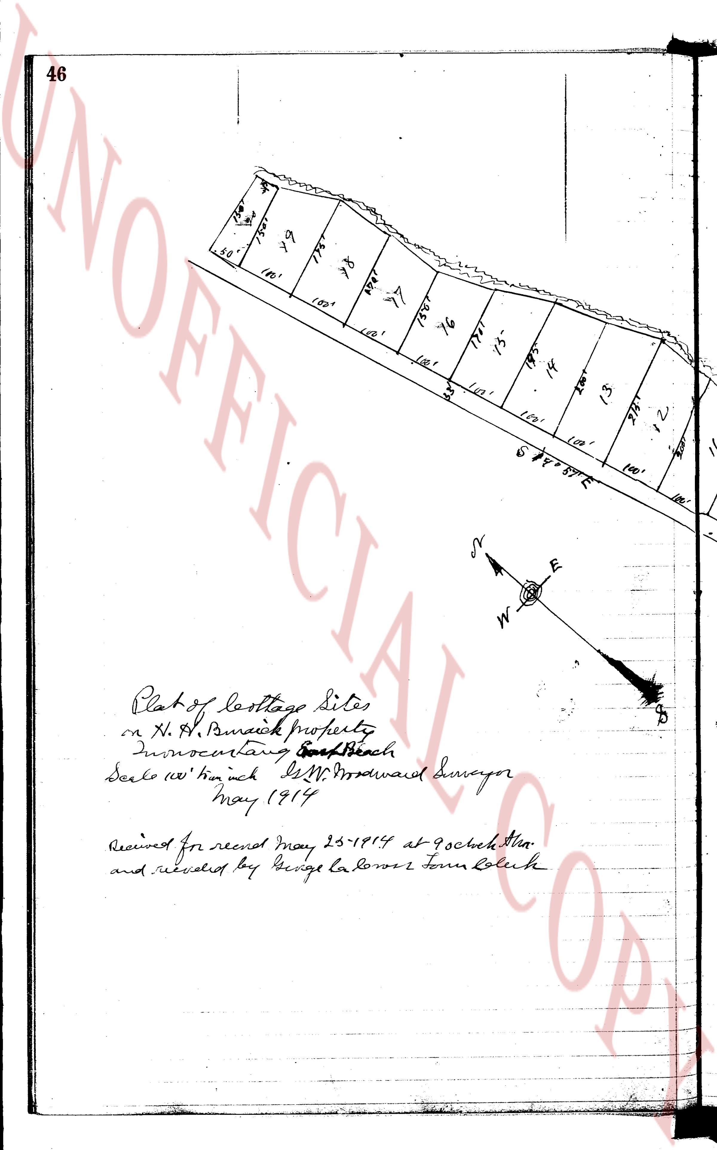
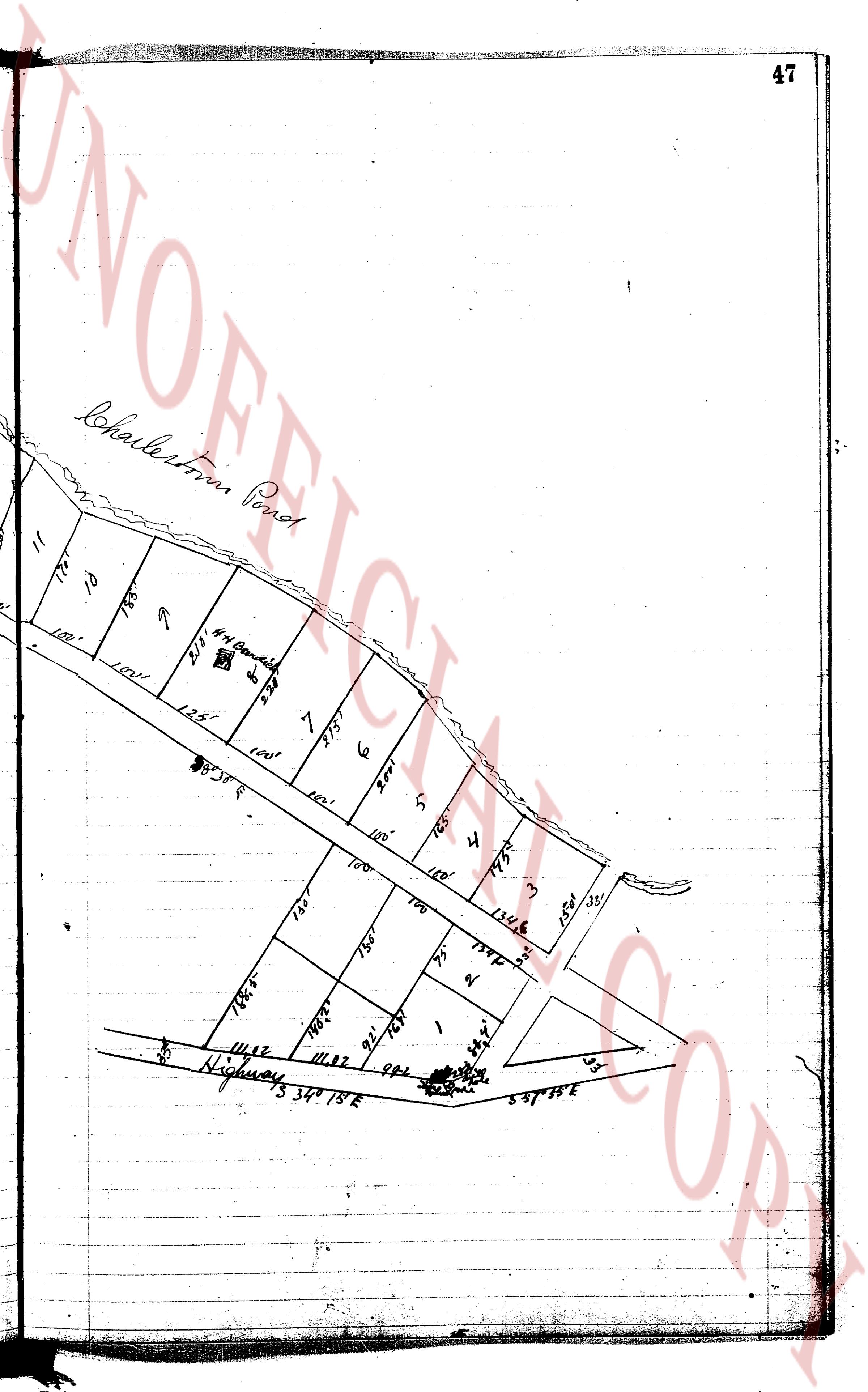
and lots described otherwise bounded and described being tracts "A" and "B" as per
the same are laid out on a map made by Leon L. Holland, Civil Engineer, dated July 1, 1935,
entitled, "Plat of Two Tracts of Land on Cove Headow at Charlestown Pond in the
Town of Charlestown, State of Rhode Island" signed by Leon L. Holland at his office in Cranston,
1935, Platted March 20, 1939, Leon L. Holland, Civil Engineer". Said tract "B" is
implied subject to the rights of the owners of the adjacent lands and their heirs and
their respective heirs and assigns to possess, pass and repair access roads straight past
this other subject to the rights of the owners of the land along the northeasterly side
of the herein described premises as shown on said plat to the Charlestown Pond.
This conveyance is made subject to taxes assessed June 15, 1944.
TO HAVE AND TO HOLD, the aforementioned premises, with all the privileges and appur-
tenances thereunto belonging unto, and to the use of said Grantees, as joint tenants and not
as tenants in common, and their heirs and assigns forever, in fee simple.
And we the said Grantors do hereby, for ourselves and for our heirs, executors and
administrators, covenant with the said Grantees and their heirs and assigns that we are law-
fully seized in fee simple of the said granted premises; that the same are free from all in-
cumbrances, except as aforesaid, that we have good right, full power and lawful authority to
sell and convey the same in the manner as aforesaid; that the said Grantees and their heirs and
assigns shall by these presents at all times hereafter peaceably and quietly have and enjoy
the said premises, and that we the said Grantors will, and our heirs executors and administra-
tors, shall warrant and defend the same to the said Grantees and their heirs and assigns forever
against the lawful claims and demands of all persons, except as aforesaid.
AND FOR THE CONSIDERATION aforesaid We, MARION G. WILSON and GRAPHTON M. WILSON, wife
and husband, do hereby release all our rights of Dowry and Curtesy, and all other right, title
and interest, statutory or otherwise, in and to the said granted premises unto the said Grantees
and their heirs and assigns, forever.
IN WITNESS WHEREOF, we have hereunto set our hands and seals this twenty-sixth day
of August in the year of our Lord one thousand nine hundred and forty four (1944).
Signed and sealed in presence of)
J. Bertram Watson
(DOCUMENTARY STAMPS, $2.75)
GRAPHTON M. WILSON (SEAL)
MARION G. WILSON (SEAL)
page 2
262
STATE of RHODE ISLAND, ETC.)
County of Providence {
{
In Providence in said County on the Twenty-sixth day of August A. D., one thousand nine
hundred and forty-four (1944) before me personally appeared the above named Grantors GRAPTON M. WILSON
and MARION G. WILSON each and all to me known, and known by me to be the parties executing the foregoing
instrument, and they acknowledged said instrument, by them executed to be their free act and
deed.
J. BERTHRAM WATSON
Notary Public.
Received for record August 29th, A. D. 1944 at 9:05 o'clock, a. m., and recorded by
[Signature]
Town Clerk
KNOW ALL MEN BY THESE PRESENTS, That We, O. LEONARD WRIGHT and MURIELL WRIGHT, both
of the City of Cranston, County of Providence, in the State of Rhode Island, hereinafter called
the mortgagors, for consideration paid, do hereby give, grant, bargain, sell and convey to the
FIRST FEDERAL SAVINGS AND LOAN ASSOCIATION OF PROVIDENCE,
a United States corporation, doing business in Providence, Rhode Island, hereinafter called
the mortgagee, its successors and assigns forever, for the purpose of securing payment of
SEVENTEEN HUNDRED and 00/100 ($1700.00) Dollars with interest thereon, as provided in a prom-
issory note of even date on which the mortgagors are the makers.
All and singular the following described land together with the buildings and im-
provements thereon:—
That certain real estate situate in the Town of Charlestown, County of Washington,
State of Rhode Island, and described as follows:
Commencing at a stone post located at the northeasterly corner of land now
or lately of Albert L. Sisson, in the westerly line of a right of way granted by
way; thence running in a southeasterly direction two hundred and eighty-
eight square-metres (288) [illegible] poles in a stone bound; thence in
continuing in the same straight line eighteen (18) feet more or less until it
intersects the southeasterly corner of land now or lately of Pond fence running in a
northerly direction following the normal water line of Charlestown Pond until
it intersects the northeasterly corner of land now or lately of the heirs of
Hananford, (formerly land of Horace L. Sisson and late of George M. Hawthorne),
thence running in a northeasterly direction seventy-five (75) square-metres [illegible]
more or less to a stone post on pline; thence continuing in the same straight
line one hundred and ninety-three (193) square-metres [illegible] to a stone set
in a stone set in the westerly line of the right of way at the northeasterly corner
of the herein conveyed premises; thence running in a southerly direction eighty-
early corner of land formerly of Horace L. Sisson and now lately of Elizabeth
Hananford two thousand three hundred and twenty-four (2324) square-metres [illegible]
tenths (9.3) foot to a stone set in the southeasterly corner of land as conveyed
to Samuel G. Sisson by indenture between W. Lodge and L. Webster by deed
dated July 1, 1903 and recorded in Land Evidence Record of Charlestown
16 pages 441 and 442; thence continuing in the same straight line fifty-five
and fifteen one-hundredths (55.15) square-metres [illegible] to a stone bound at the
beginning, bounded southeasterly by land now or lately of Albert L. Sisson,
southeasterly by the normal water line of Charlestown Pond, northerly by land
now or lately of Elizabeth Hananford and easterly by a water way as granted by
deed of copy A. Webster to Samuel G. Sisson December 29, 1891 and recorded
in Book 15 pages 31 and 32, and however otherwise described and bounded being
tracts 14 and 15 on the "Plat of Two Tracts of Land on Cove Meadow at Charles-
town Pond in the Town of Charlestown, County of Washington" as shown on
Surveyed April, 1935, Platted March 24, 1939, Leon L. Holland, Civil Engineer.
Said tract "B" is conveyed subject to the right of Herbert W. Sisson and Clifford
P. Shabtuck, their representatives and successors, to pass and repass across
said tract "B" with either teams or on foot from the right of way on the north-
easterly side of the herein described premises as shown on said plat to Charlestown Pond.
The page as recorded