The instrument's own words
page 1 · read by Gemma vision
495
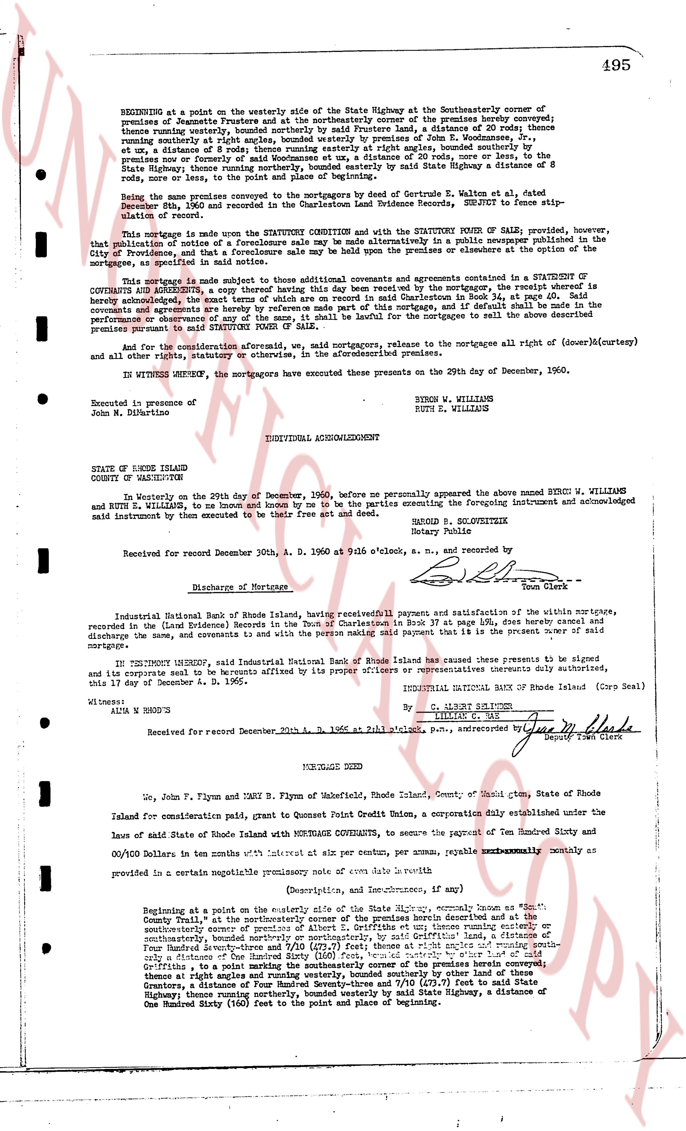
BEGINNING at a point on the westerly side of the State Highway at the Southeasterly corner of the premises of Jeannette Frustere and at the northeasterly corner of the premises hereby conveyed; thence running easterly, bounded southerly by the premises of [?] [?], a distance of 30 Rhode running easterly at right angles, bounded westerly by premises of John E. Woodmansees, Jr., et ux, a distance of 8 rods; thence running easterly at right angles, bounded southerly by the premises run or formerly run by [?] [?], a distance of 30 rods, more or less to the State Highway; thence running northerly, bounded easterly by said State Highway a distance of 8 rods; thence, to the point of beginning.
Being the same premises conveyed to the mortgagors by deed of Gertrude W. Walton, et al dated December 8th, 1960 and recorded in the Charlestown Land Evidence Books, SUBJECT to fence agreements.
This mortgage is made under the STATUTE CONDITION and with the STATUTORY POWER OF SALE; provided, however, that notification of notice of a foreclosure sale may be made alternatively in a public newspaper published in the City of Providence, and that a foreclosure sale may be held up on the premises alone or at the courthouse where the mortgage, as specified in said notice.
This mortgage is made subject to those additional covenants and agreements contained in the STATUTORY OF COVENANTS AND AGREEMENTS, a copy thereof of which is this day read by the mortgagor, the receipt of whereof is hereby acknowledged, the exact terms of which are recorded in said Charlestown Book 37, at page 49, said Covenants and agreements are hereby by reference made part of this mortgage, and if default shall occur in the performance of any covenant or agreement herein contained, the mortgagee may cause the premises to sell the above described premises pursuant to said STATUTORY POWER OF SALE.
And for the consideration aforesaid we, said mortgagor, release to the mortgagee all right of (dower)&(curtesy) and all other rights, estates or otherwise, in the aforementioned premises.
IN WITNESS WHEREOF, the mortgagors have executed this present on the 29th day of December, 1960.
BYRON W. WILLIAMS
RUTH E. WILLIAMS
Executed in presence of
John M. DiNartino
INDIVIDUAL ACKNOWLEDGMENT
STATE OF RHODE ISLAND
COUNTY OF WASHINGTON
In Westerly on the 29th day of December, 1960, before me personally appeared the above named BYRON W. WILLIAMS and RUTH E. WILLIAMS, to me known and by me to be the parties executing the foregoing instrument and acknowledged said instrument then by execute and to be their free act and deed.
BARON B. SLOVOKZEITIK
Notary Public
Received for record December 30th, A. D. 1960 at 9:16 o'clock, a. m., and recorded by
[Signature]
Town Clerk
Discharge of Mortgage
Industrial National Bank of Rhode Island, having received full payment and satisfaction of the within mortgage, recorded in the (Land Evidence Books) in the Town of Charlestown in Book 37 at page 149, does hereby cancel and discharge the same, and covenants to the person making said payment that it is the present owner of said mortgage.
IN TESTIMONY WHEREOF, said Industrial National Bank of Rhode Island has caused these presents to be signed and its corporate seal to be affixed by its proper officers or representatives thereunto duly authorized, this 17 day of December A. D. 1965.
WITNESS:
ALIA W. NORDY'S
INDUSTRIAL NATIONAL BANK OF Rhode Island (Corp Seal)
By C. ALBERT SOLOMON
OFFICER
Received for record December 20th, 1965 A. D. 1965 at 1:15 p.m. [?], and recorded by [Signature]
Deputy Town Clerk
----
MORTGAGE DEED
We, John F. Flynn and Mary B. Flynn of Wakefield, Rhode Island, County of Washington, State of Rhode Island for consideration paid, grant to Quonset Point Credit Union, a Corporation duly established under the laws of State of Rhode Island with MORTGAGE COVENANTS, to secure the payment of Ten Hundred Sixty and 00/100 Dollars in ten months with interest at six per centum per annum, payable EXCLUSIVELY monthly as provided in a certain negotiable promissory note of even date herewith
(Description, and Incumbrances, if any)
BEGINNING at a point on the easterly side of the State Highway, commonly known as "South County Trail", at the northeasterly corner of premises of Griffitts and up thence running easterly or southeasterly corner of premises of Griffitts and up thence running easterly or southeasterly, bounded northerly or northeasterly, by said Griffitts land, a distance of 140 feet; thence running Southeasterly, bounded northerly by premises of [?] [?] at right angles and running south a distance of One Hundred Sixty (160) feet, bounded easterly by the premises of herein conveyed; thence at right angles and running westerly, bounded southerly by other land of these Griffitts, a distance of 140 feet; thence running north west 7/8 (7/8) feet to said State Highway; thence running northerly, bounded westerly by said State Highway, a distance of One Hundred Sixty (160) feet to the point and place of beginning.
page 2 · read by Gemma vision
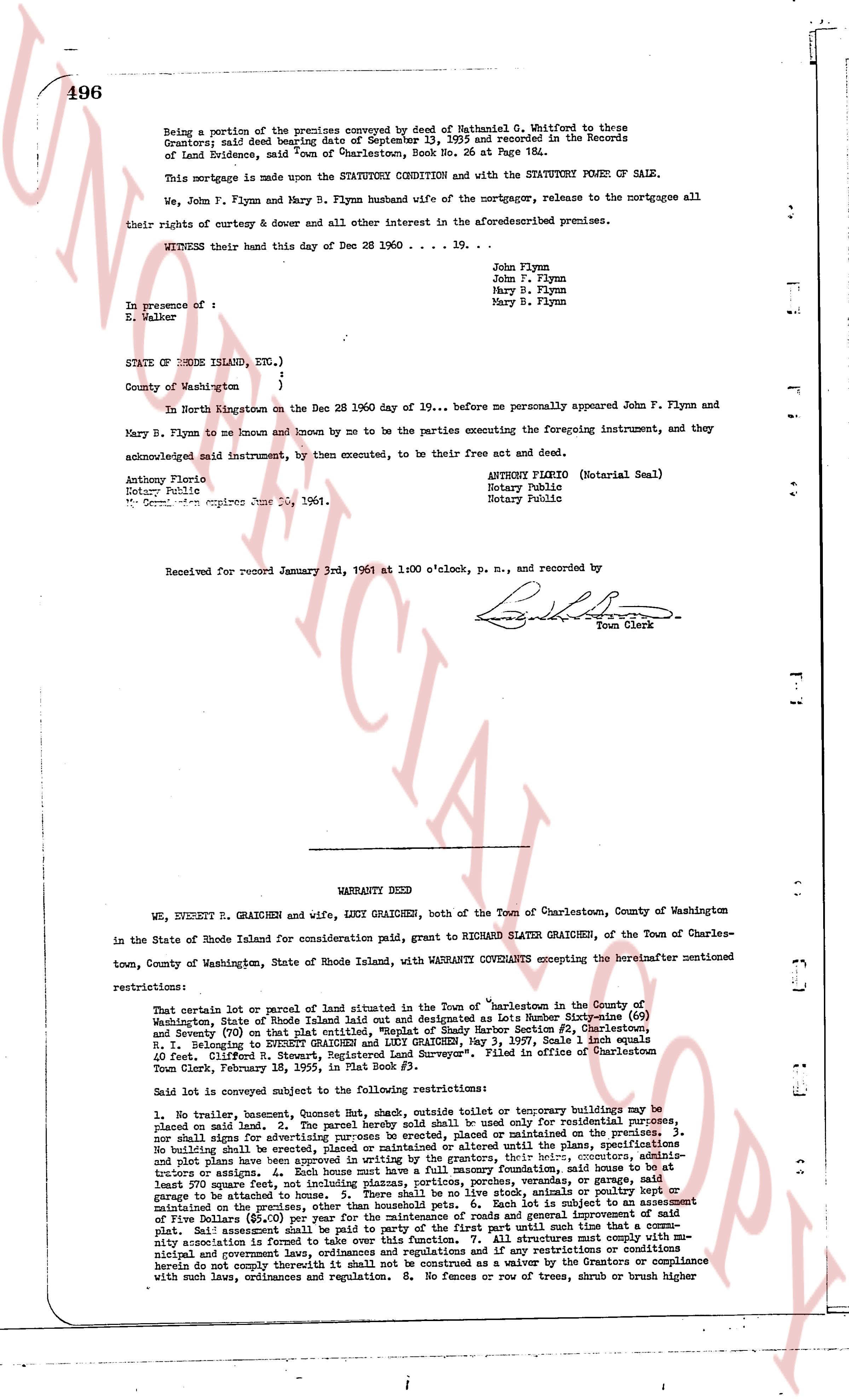
Being a portion of the premises conveyed by deed of Nathaniel G. Whitford to these
Grantors; said deed bearing date of December 15, 1899 and Recorded in the Records
of Land Evidence, said Town of Charlestown, Book No. 26 at Page 184.
This mortgage is made upon the STATUTORY CONDITION and with the STATUTORY POWER OF SALE.
We, John F. Flynn and Mary B. Flynn husband wife of the mortgagor, release to the mortgagee all
their rights of curtesy & dower and all other interest in the aforementioned premises.
WITNESS their hand this day of Dec 28 1960 . . . . 19. . .
John Flynn
John F. Flynn
Mary B. Flynn
Mary B. Flynn
In presence of :
E. Walker
STATE OF RHODE ISLAND, ETC.,)
)
County of Washington )
In North Kingstown on the Dec 28 1960 day of 19. . . before me personally appeared John F. Flynn and
Mary B. Flynn to me known and known by me to be the parties executing the foregoing instrument, and they
acknowledged said instrument, by then executed, to be their free act and deed.
Anthony Florio
Notary Public
My Commission expires June 26, 1961.
ANTHONY FLORIO (Notarial Seal)
Notary Public
Notary Public
Received for record January 3rd, 1961 at 1:00 o'clock, p. m., and recorded by
[Signature]
Town Clerk
----
WARRANTY DEED
WE, EVERETT R. GRAICHEN and wife, LUCY GRAICHEN, both of the Town of Charlestown, County of Washington
in the State of Rhode Island for consideration paid, grant to RICHARD SLATER GRAICHEN, of the Town of Charles-
town, County of Washington, State of Rhode Island, with WARRANTY COVENANTS excepting the hereinafter mentioned
restrictions:
That certain lot or parcel of land situated in the Town of Charlestown in the County of
Washington, State of Rhode Island Land laid out and designated as Lots Number Seventy-nine (69)
and Seventy (70) on that plat entitled, "Sketch of Shady Shore Section #2, Charlestown, R.I." referring to RECORD Book A, Page 113, dated Nov. 3, 1937. Said Lots both equals
40 feet. Clifford N. Stewart, Registered Land Surveyor". Filed in office of Charlestown
Town Clerk, February 18, 1945, in Plat Book #1.
Said lot is conveyed subject to the following restrictions:
1. No trailer, house boat, houseboat, shed, shack, outside toilet or temporary buildings may be
placed on said land. 2. The parcel hereby sold shall be used only for residential purposes.
No shop shall be erected on the premises, nor shall any business be conducted on the premises. 3.
No shall be erecting as a fence any material other than maintained or altered until the specifications
and plot plans have been approved in writing by the grantor. 4. The house, including the garage, shall
least 70 feet square, not including plan, projections, porches, portions, porches, [?]
structures or stairs. 5. Except for a basement or a concrete foundation, said house is to be at
first story on grade. 6. No livestock, poultry, bees, dogs, stock, animals or dog kennel or
garage is to be situated on the premises, nor shall any stock, animals or dog kennel be
maintained on the premises, other than household pets. 6. Each lot is subject to an assessment of
five Dollars ($5.00) per year for the maintenance and general improvement of said
plat. Said assessment shall be paid to the party of the first part until such time that a com-
mity association is formed and takes over the responsibility to ensure that fixtures meet with mu-
nicipal and government laws, ordinances and regulations and if any restrictions or conditions
become void or empty through time or are altered or waived by the consensus or concurrence
with such laws, ordinances and regulation. 8. No fences or row of trees, shrub or brush higher
The page as recorded