The instrument's own words
page 1 · read by Gemma vision
189
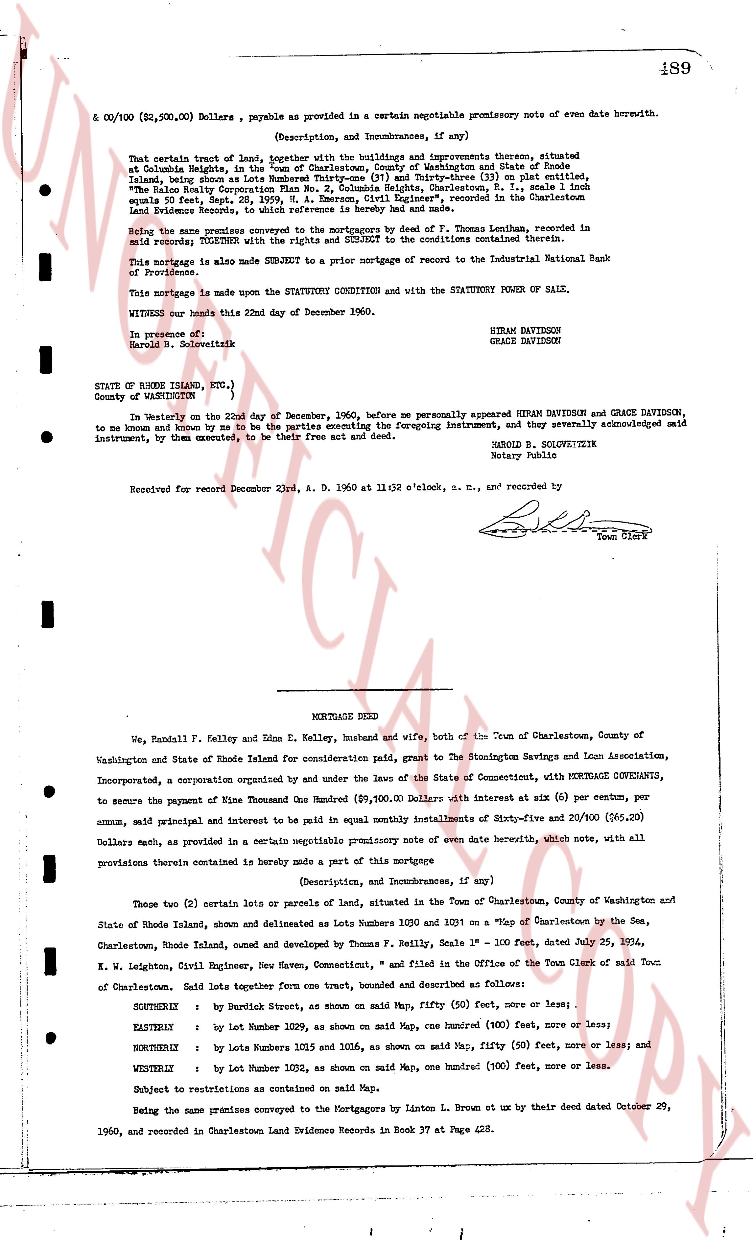
& $00/100 ($2,500.00) Dollars , payable as provided in a certain negotiable promissory note of even date herewith.
(Description, and Incumbrances, if any)
That certain tract of land, together with the buildings and improvements thereon, situated at Columbia Heights, in the "town of Charlestown, County of Washington and State of Rhode Island, being more or less 8,000 square feet, as shown on Plat-three (3) on plat entitled, "The Halo Realty Corporation Plan No 2, Columbia Heights, Charlestown, R. I., scale 1 inch equals 50 feet, Sep. 28, 1959, A. N. Emerson, Civil Engineer", recorded in the Charlestown Land Evidence Records, in book 36 at page 431, and more.
Being the same premises conveyed to the mortgagors by deed of F. Thomas Lenihan, recorded in said records; TOGETHER with the rights and SUBJECT TO the conditions contained therein.
This mortgage is also made SUBORDINATE to a prior mortgage of record to the Industrial National Bank of Providence.
This mortgage is made upon the STATUTORY CONDITION and with the STATUTORY POWER OF SALE.
WITNESS our hands this 22nd day of December 1960.
In presence of:
Harold B. Soloveitzik
HIRAM DAVIDSON
GRACE DAVIDSON
STATE OF RHODE ISLAND, ETC.,
COUNTY OF WASHINGTON
In Westerly on the 22nd day of December, 1960, before me personally appeared HIRAM DAVIDSON and GRACE DAVIDSON, to me known and known by me to be the parties executing the foregoing instrument, and they severally acknowledged said instrument, by them executed, to be their free act and deed.
HAROLD B. SOLOVEITZEIK
Notary Public
Received for record December 23rd, A. D. 1960 at 11:32 o'clock, a. m., and recorded by
[Signature]
Town Clerk
----
MORTGAGE DEED
We, Randall F. Kelley and Edna E. Kelley, husband and wife, both of the Town of Charlestown, County of Washington and State of Rhode Island for consideration paid, grant to The Stonington Savings and Loan Association, Incorporated, a corporation organized by and under the laws of the State of Connecticut, with MORTGAGE COVENANTS, to secure the payment of Mine Thousand One Hundred ($9,100.00) Dollars with interest at six (6) per centum, per annum, and principal interest and to be paid in equal monthly installments of Sixty-five and 20/100 ($65.20) Dollars each, as provided in a certain negotiable promissory note of even date herewith, which note, with all provisions thereby contained is hereby made a part of this mortgage
(Description, and Incumbrances, if any)
Those two (2) certain lots or parcels of land, situated in the Town of Charlestown, County of Washington and State of Rhode Island, shown and delineated as Lots Number 1020 and 1021 on a "Map of Charlestown by the Sea, Charlestown, Rhode Island, owned and developed by Thomas F. Kelley, Scale 1" = 100 feet, dated July 25, 1924, W. W. Leighton, Civil Engineer, New Haven, Connecticut," and filed in the Office of the Town Clerk of said Town of Charlestown. Said lots together form one tract, bounded and described as follows:
SOUTHERLY : by Burdick Street, as shown on said Map, fifty (50) feet, more or less;
EASTERLY : by lot number 1029, as shown on said Map, one hundred (100) feet, more or less;
NORTHERLY : by Lots numbers 1016 and 1016, as shown on said Map, fifty (50) feet, more or less; and
WESTERLY : by lot Number 1032, as shown on said Map, one hundred (100) feet, more or less.
Subject to restrictions as contained on said Map.
Being the same premises conveyed to the Mortgagors by the Linton B. Brown etx by their deed dated October 29, 1960, and recorded in Charlestown Land Evidence Records in Book 37 at Page 428.
page 2 · read by Gemma vision
490
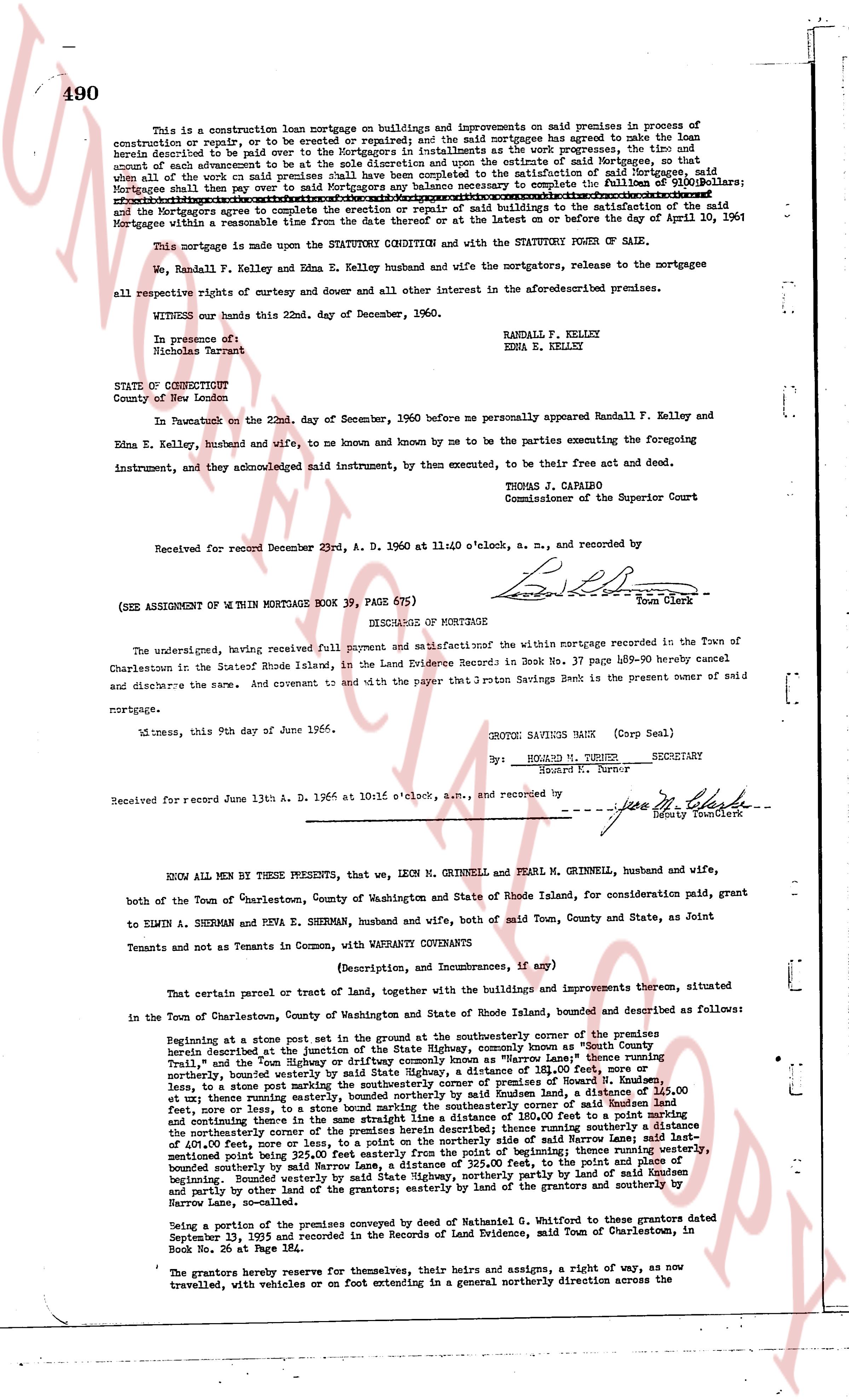
This is a construction loan mortgage on buildings and improvements on said premises in process of construction or repair, or to be erected or rebuilt; and the said mortgagees have agreed to make the loan herein described and it is paid over to said mortgagors in installments as the work progresses, the time and amount of each advancement to be at the sole discretion and upon the estimate of said Mortgagees, so that when all such advances are paid over to said mortgagors or the satisfaction of said Mortgagees, said Mortgagees shall then pay over to said Mortgagors any balance necessary to complete the fullness of $10,000 Dollars; after such sum has been paid over to said Mortgagors, the said Mortgagees shall cease to make advances and the Mortgagors agree to the completion or repair or rebuild of said buildings to the satisfaction of the said Mortgagees within a reasonable time from the date therewith or at the latest on or before the 1st day of April 1961.
This mortgage is made under the STATUTORY CONDITION and with the STATUTORY POWER OF SALE.
We, Randall F. Kelley and Edna E. Kelley husband and wife the mortgagors, release to the mortgagees all respective rights of curtesy and dower and all other interest in the aforesaid described premises.
WITNESS our hands this 22nd day of December, 1960.
In presence of:
Randall F. Kelley
Edna E. Kelley
Hildred Porter
STATE OF CONNECTICUT
County of New London
On this Twenty-second on the 22nd day of December, 1960 before me personally appeared Randall F. Kelley and Edna E. Kelley, husband and wife, to me known and by me to be the parties executing the foregoing instrument, and they acknowledged said instrument, by then executed, to be their free act and deed.
THOMAS J. CAPARO
Commissioner of the Superior Court
Received for record December 23rd, A. D. 1960 at 11:40 o'clock, a. m., and recorded by
[Signature]
Town Clerk
----
(SEE ASSIGNMENT OF $\text{W}$ WITHIN MORTGAGE BOOK 39, PAGE 67$\text{E}$)
DISCHARGE OF MORTGAGE
The undersigned, having received full payment and satisfaction of the within mortgage recorded in the Town of Charlestown in the State of Rhode Island, in the Land Evidence Record in Book 37 Page 489-90 hereby cancel and discharge the same. And covenant and say that the proton Savings Bank is the present owner of said mortgage.
Witness, this 9th day of June 1966.
PROTON SAVINGS BANK (Corp Seal)
By: [Signature]
EDWARD M. TURNO SECRETARY
Edward R. Turnor
Received for record June 13th A. D. 1966 at 10:15 o'clock, a.m., and recorded by
[Signature]
Deputy Town Clerk
----
KNOW ALL MEN BY THESE PRESENTS, that we, LEON M. GRINNELL and PEARL M. GRINNELL, husband and wife, both of the Town of Charlestown, County of Washington and State of Rhode Island, for consideration paid, grant to EDIN A. SHERMAN and PEVA E. SHERMAN, husband and wife, both of said Town, County and State, as Joint Tenants and not as Tenants in Common, with WARRANTY CONVEYANCE
(Description, and Incumbrances, if any)
That certain parcel or tract of Land, together with the buildings and improvements thereon situated in the Town of Charlestown, County of Washington and State of Rhode Island, bounded and described as follows:
Beginning at a stone post set in the ground at the southeasterly corner of the premises conveyed herein described at the junction of the State Highway, commonly known as North Road and Common Road; thence running North and the High Way known as "Harrow Lane" thence running North 45 degrees West along the High Way known as "Harrow Lane" thence running North 45 degrees West along the High Way known as "Harrow Lane" distance of 215 feet, to stones post marking the southeasterly corner of the premises conveyed to us by Howard R. Bounden; thence northerly, bounded westerly by State Highway, a distance of 185 feet, to a stone post; thence east 40 feet, onto a lot p. [?] and thence northerly, bounded easterly by said Bounden Land, a distance of 145 feet, to stones post, on a line to a stone post, bounded northerly by said Bounden Land, a distance of 100 feet, to the northeasterly corner, and thence running south 45 degrees East, a distance of 100 feet, and continuing thence in the same straight line a distance of 180 feet to a point marking the southeasterly corner of the premises conveyed to us by said Bounden; thence running southeasterly a distance of 401.00 feet, more or less, to a point on the northerly side of said Harrow Lane; said last mentioned point being the southeasterly corner of the premises conveyed by said Bounden; thence running southeasterly along said Harrow Lane, a distance of 215 feet, to the point and place of beginning; bounded easterly partly by said Bounden Land and partly by the land of the grantors; easterly by land of the grantors and southerly by Bounden Lane, so outlined.
Being a portion of the premises conveyed by deed of Nathaniel G. Whitford to these grantors dated September 13, 1935 and recorded in the Records of Land Evidence, said Town of Charlestown, in Book No. 26 at Page 182$\text{L}$.
The grantors hereby reserve for themselves, their heirs and assigns, a right of way, as now travelled, with vehicles or on foot entering in a general northerly direction across the
The page as recorded