The instrument's own words
page 1 · read by Gemma vision
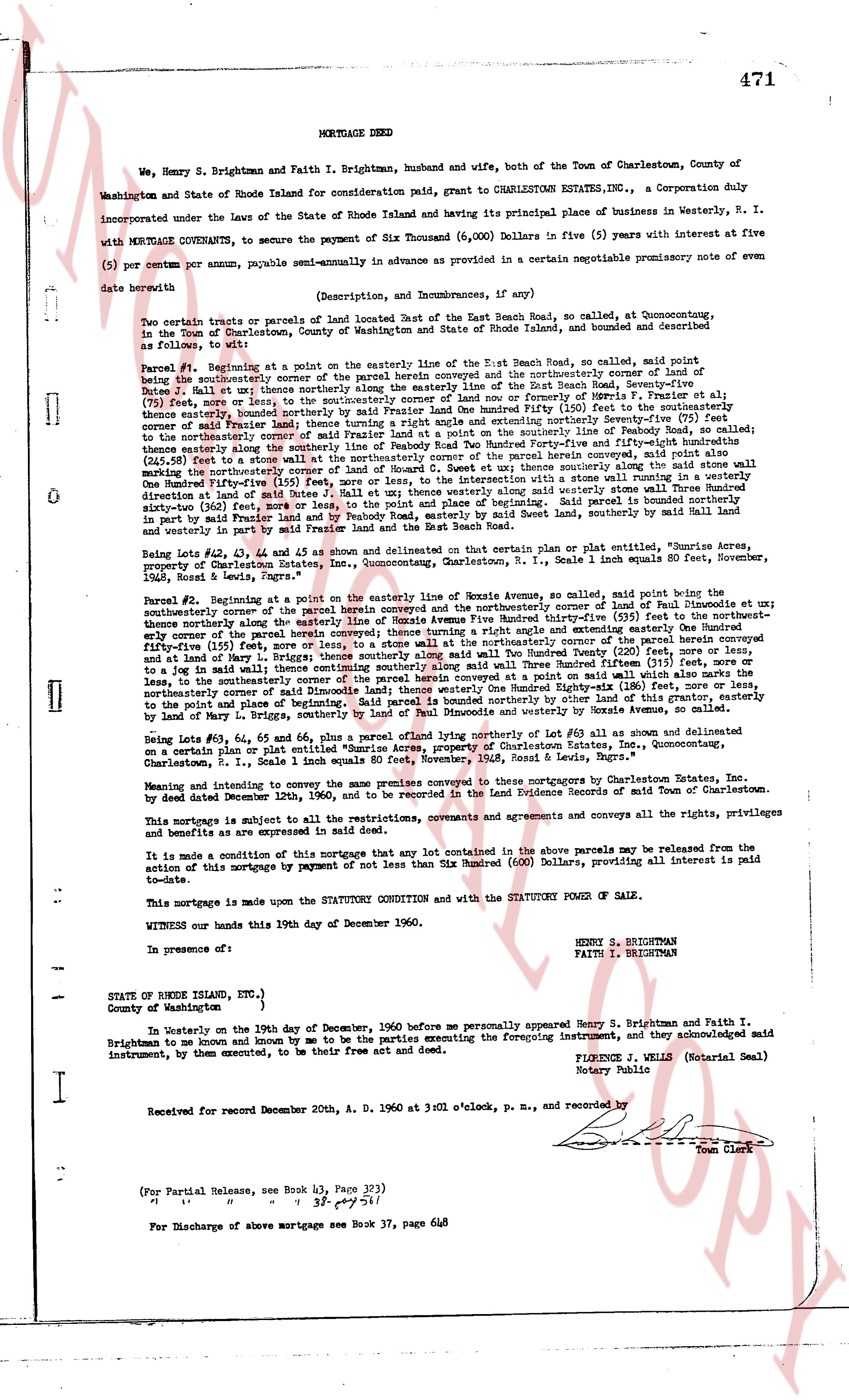
471
MORTGAGE DEED
We, Henry S. Brightman and Faith I. Brightman, husband and wife, both of the Town of Charlestown, County of Washington and State of Rhode Island for consideration paid, grant to CHARLESTOWN ESTATES INC., a Corporation duly incorporated under the Laws of the State of Rhode Island and having its principal place of business in Westerly, R. I. with MORTGAGE COVENANTS, to secure the payment of Six Thousand (6,000) Dollars in five (5) years with interest at five (5) per centum per annum, payable semi-annually in advance as provided in a certain negotiable promissory note of even date herewith
(Description, and Encumbrances, if any)
Two certain tracts or parcels of land bounded East the East Beach Road, so called, at Quonocutting, in the Town of Charlestown, County of Washington, State of Rhode Island, bounded and described as follows, to wit:
Parcel #1: Beginning at a point on the easterly line of the East Beach Road, so called, said point being southeasterly corner of the parcel herein conveyed and the northeasterly corner of the land of Dune J. Mall et al; thence southeasterly along the easterly line of the East Beach Road, seventy-five (75) feet; thence northerly along the southerly line of the land of Dune J. Mall et al; thence southeasterly, bounded northerly by said Frazer land A one Hundred Fifty (150) feet to the southeasterly corner of said Mall land; thence northerly along the easterly line of said Mall land, one hundred seventy-six (176) feet to the southeasterly corner of said Frazer land at a point on the southerly line of the Peabody Road, so called; thence easterly along the southerly line of said Peabody Road, one hundred seventy-four (174) feet, to a said nail marking the northeasterly corner of said land wall the northeasterly corner of the parcel herein conveyed, said point also being the northeasterly corner of the land of Paul Dinocalce et al, thence to the intersection with a stone wall running in a westerly direction at said rate 3° East; Mall et al; thence westerly along said stone wall running in a westerly direction at said rate 3° East; Mall et al; thence westerly along the southerly line of said stone wall making the northeasterly corner of said land, to the point of beginning. Said parcel is bounded northerly by said Peabody Road, easterly by said Mall land and westerly, in part by said Frazer land and by Peabody Road, easterly by said Nevel land, southerly by said Mall land and westerly in part by said Mall land.
Being Lot #42, Lot #43, Lot #44 and Lot #45 as shown and delineated on certain plat or plan entitled, "Brunette acres, property of Charlestown Estates, Inc., Quonocutting, Charlestown, R. I., Scale 1 inch equals 80 feet, November, 1960," signed by Louis & Lewis, Engineers.
Parcel #2: Beginning at a point on the easterly line of Bonnie Avenue, so called, said point being the southeasterly corner of the parcel herein conveyed and the northeasterly corner of land of Paul Dinocalce et al; thence northeasterly along the easterly line of Bonnie Avenue, one hundred seventy-five (175) feet, to the northeasterly corner of the parcel herein conveyed; thence turning a right angle and extending easterly One Hundred Fifty (150) feet, to a nail marking the northeasterly corner of the parcel herein conveyed, and the northeasterly corner of land of Mary B. Brignone et al; thence southerly along the easterly line of said Brignone land, Two Hundred Twenty (220) feet, more or less, to a said nail marking the southeasterly corner of said Brignone land and the southeasterly corner of said land, or less, to the southeasterly corner of the parcel herein conveyed at a point on said wall which also marks the northeasterly corner of said land of Mary B. Brignone, turning a right angle and extending westerly One Hundred Fifty (150) feet, to the point of beginning. Said parcel is bounded northerly by other land of this grantor, easterly by land of Mary B. Brignone, southerly by land of Paul Dinocalce and westerly by Bonnie Avenue, so called.
Being Lot #46, Lot #47, Lot #48 and Lot #49, as shown and delineated as part of Lot #41 as shown and delineated on a map dated December 19th, 1960, entitled "Brunette acres, property of Charlestown Estates, Inc., Quonocutting, Charlestown, R. I., Scale 1 inch equals 80 feet, November, 1960," signed by Louis & Lewis, Engineers.
Meaning and intend to convey the same premises conveyed to this mortgagor by Charlestown Estates, Inc. by deed dated December 19th, 1960, and recorded in the Land Evidence Records of said Town of Charlestown.
This mortgage is subject to all the restrictions, covenants and agreements and conveys all the rights, privileges and benefits as are expressed in said deed.
It is made a condition of this mortgage that any lot contained in the above parcels may be released from the action of this mortgage by payment of not less than Six Hundred (600) Dollars, providing all interest is paid to-date.
This mortgage is made upon the 19th STATUTORY CONDITION and with the STATUTORY POWER OF SALE.
WITNESS our hands this 19th day of December 1960.
HENRY S. BRIGHTMAN
FAITH I. BRIGHTMAN
In presence of: [?]
STATE OF RHODE ISLAND, ETC.,
County of Washington
In Westerly on the 19th day of December, 1960 before me personally appeared Henry S. Brightman and Faith I. Brightman, known by me and known by me to be the parties executing the foregoing instrument, and they acknowledged said instrument, by them executed, to be their free act and deed.
FLORENCE J. WELLS (Notary Memorial Seal)
Notary Public
Received for record December 20th, A. D. 1960 at 3:01 o'clock, p. m., and recorded by [?]
(For Partial Release, see Book 43, Page 332)
" " " " 37 p. 471 s. 1
For Discharge of above mortgage see Book 37, page 648
The page as recorded