The instrument's own words
page 1 · read by Gemma vision
468
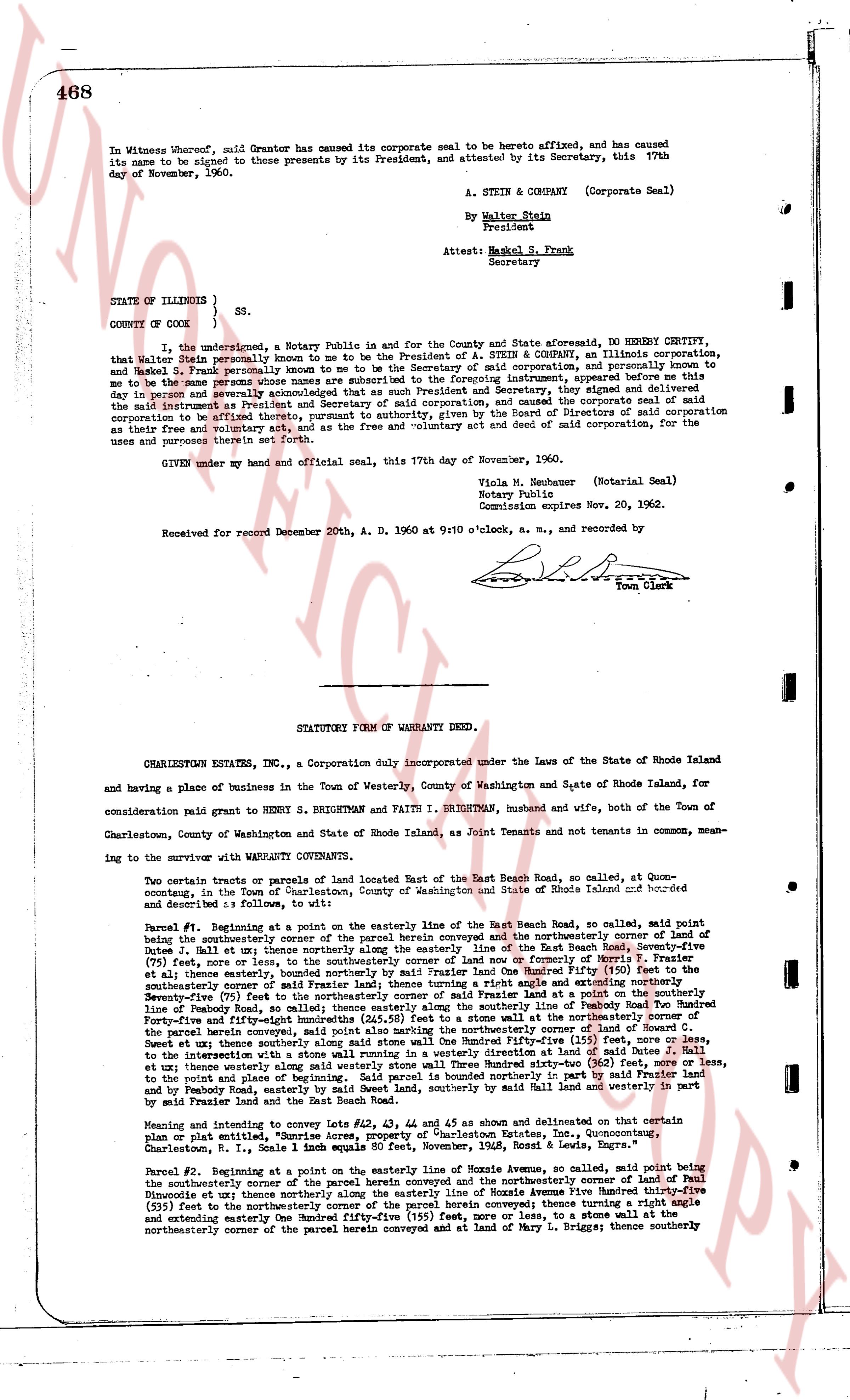
In Witness Whereof, said Grantor has caused its corporate seal to be hereto affixed, and has caused
its name to be signed to these presents by its President, and attested by its Secretary, this 17th
day of November, 1960.
A. STEIN & COMPANY (Corporate Seal)
By Walter Stein
President
Attest: Harold S. Frank
Secretary
STATE OF ILLINOIS }
COUNTY OF COOK } ss.
I, the undersigned, a Notary Public in and for the County and State aforesaid, DO HEREBY CERTIFY,
that Walter Stein personally known to me to be the President of A. STEIN & COMPANY, an Illinois corporation,
and Harold S. Frank personally known to me to be the Secretary of said corporation, and personally known to
me to be the same persons whose names are subscribed to the foregoing instrument) appeared this day
in my presence and personally acknowledged that as such President and Secretary, they signed and delivered
the said instrument as President and Secretary of said corporation, and caused its corporate seal to be
affixed thereto, and that they did so by virtue of a resolution of the Board of Directors of said corporation
as their free and voluntary act and deed, and as the free and voluntary act and deed of said corporation, for the
uses and purposes therein set forth.
GIVEN under my hand and official seal, this 17th day of November, 1960.
Viola M. Neuhauer (Notarial Seal)
Notary Public
Commission expires Nov. 20, 1962.
Received for record November 20th, A. D. 1960 at 9:10 o'clock, a. m., and recorded by [Signature]
Town Clerk
----
STATUTORY FORM OF WARRANTY DEED.
CHARLESTOWN ESTATES INC., a Corporation duly incorporated under the Laws of the State of Rhode Island
and having a place of business in the Town of Westerly, County of Washington and State of Rhode Island, for
consideration paid grant to HENRY S. BRIGHTMAN, husband and wife, both of the Town of
Charlestown, County of Washington and State of Rhode Island, as Joint Tenants and not tenants in common, mean-
ing to the survivor with WARRANTY CONVEYANCE.
Two certain tracts or parcels of land located East of the East Beach Road, so called, at Quonset-
counting, in the Town of Charlestown, County of Washington and State of Rhode Island described and
detailed as follows: to wit:
Parcel #1. Beginning at a point on the easterly line of the East Beach Road, so called, said point being
the southeasterly corner of the parcel herein conveyed and the southeasterly corner of land of Paul
Dinneen et al; thence running southerly along the easterly line of the East Beach Road, seventy-five
(75) feet, more or less, to the southeasterly corner of land now or formerly of East Beach Road
(the East Beach Road being 100 feet wide, the said boundary being the center of the Hundred Fifty (150) feet to
the easterly boundary, seventy-five (75) feet from the center), thence turning a right angle and extending north-
westerly, the southerly corner of said Faithman land; thence turning a right angle and extending north-
easterly, seventy-five (75) feet, more or less, to the northeasterly corner of land now or formerly of East Beach
linearly of Peabody Road, so called; thence easterly along the southerly line of Peabody Road to the northeasterly
corner of land of Howard C. Sweet and wife; thence southerly along the easterly line of said Sweet land to the north-
easterly corner of the parcel herein conveyed, said point also marking the northeasterly boundary of land of Howard C.
Sweet and wife; thence northwesterly along the northerly boundary of said Sweet land to the northeasterly corner,
to the intersection with a stone wall running in a westerly direction and a line marking the easterly boundary of land of Paul
Dinneen et al; thence northerly along the easterly boundary of said Dinneen land, eighty-five (85) feet, more or less,
to the point and place of beginning. Said parcel is bounded northerly in part by said Faithman land and
by Peabody Road, east by East Beach Road, southerly by said Faithman land and westerly in part
by said Dinneen land and the East Beach Road.
Meaning and intending to convey lots #23, #24, #43 and #44 as shown and indicated on the certain
plan or plat entitled, "Real Estate Map of Charlestown Estates, Inc., Quonsetcounting,
Charlestown, R. I., Scale 1 inch equals 80 feet, November, 1958, Ross & Lewis, Engrs."
Parcel #2. Beginning at a point on the easterly line of Moxie Avenue, so called, said point being the
southeasterly corner of the parcel herein conveyed and the northeasterly corner of land of Paul
Dinneen et al; thence running southerly along the easterly line of Moxie Avenue One Hundred thirty-five
(535) feet to the northeasterly corner of the parcel herein conveyed; thence turning a right angle
and extending easterly one hundred thirty-five (135) feet, more or less, to a stone wall marking the
northeasterly corner of the parcel herein conveyed and of land of Mary L. Briggs; thence southerly
page 2 · read by Gemma vision
469 |
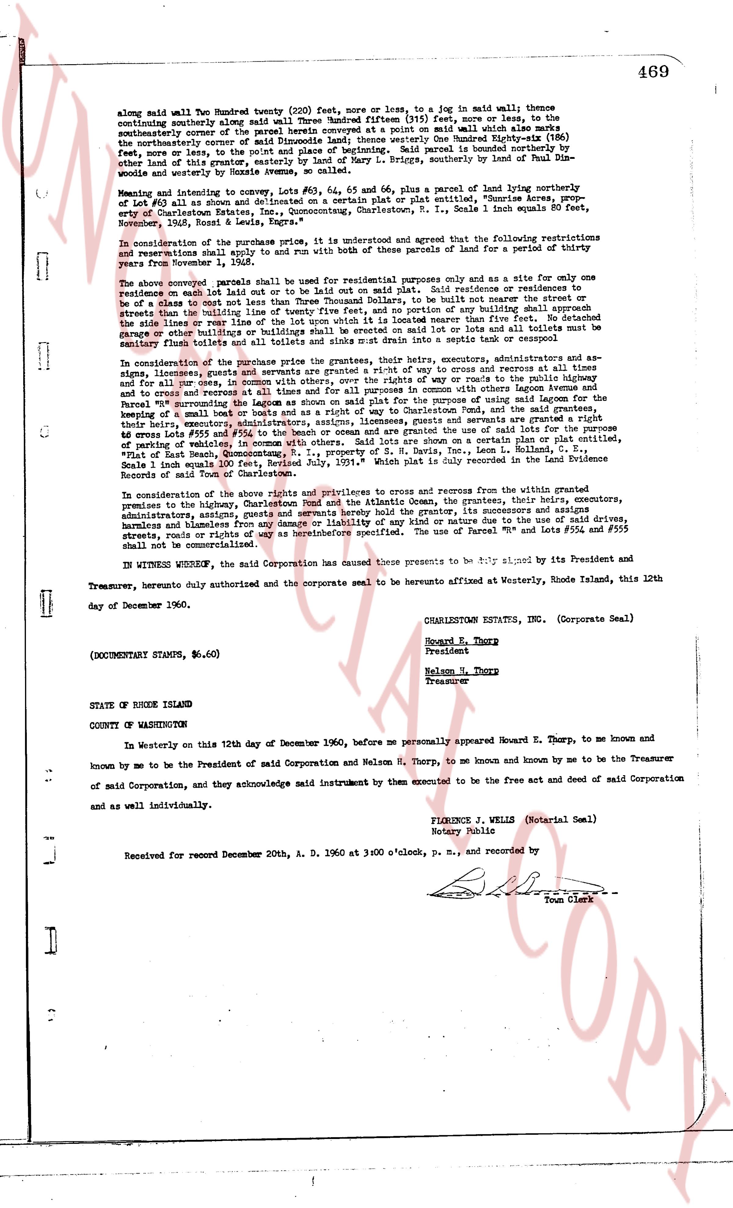
along said wall Two Hundred twenty (220) feet more or less, to a log in said wall; thence continuing southerly along said wall Three Hundred fifteen (315) feet, more or less, to the southeasterly corner of the parcel herein conveyed at a point on said wall which also marks the northeasterly corner of said Dinmods land; thence westerly One Hundred Ninety-eight (198) feet, more or less, to the westerly line of said Dinmods land; said parcel is bounded northerly by other land of this grantor, easterly by land of Mary L. Brightman, southerly by land of Paul Dimnod and westerly by land of Paul Dimnod.
Mention is hereby inviting to convey, Lots #54, #55, 64 and 65, plus a parcel of land hereby northeasterly of Lot #53 as also shown and delineated on a certain plan or plat certified, entitle "Rhume acres, prop. extension of Charlestown Estates, Inc. accompanying, Charlestown, R. I. Scale 1 inch equals 80 feet, September, 1958, Ross & Lewis, Engrs."
In consideration of the purchase price, it is understood and agreed that the following restrictions and reservations shall apply to and run with this and other pieces of land for a period of twenty years from December 12, 1960:
The above conveyed parcels shall be used for residential purposes only and as a site for only one residence on each lot laid out or to be laid out on said parcels said residences or residences to be erected shall not cost less than Two Thousand Dollars, to be built with neither the street or streets than the building line of twenty five feet, and no portions of any building shall be within forty feet of the side lines or rear lines of the lot, nor shall any structure be nearer than five feet. No detached garage or other buildings shall be built on said lots or in said lots and no toilets must be situated at distance less than twenty feet from any building or any street, road or alley.
In consideration of the purchase price the grantors, their heirs, executors, administrators and assigns, licensees, grantees and servients are granted a right of way to access and recourse at all times and for all purposes on one lot or parcel of land to be determined by way of road to the pacific Ocean and to cross and recross at all times and for all purposes in common with others legumes Ocean avenue and the parcels of parking vehicle, in consideration of the purpose of said parking lot and for the purpose of keeping a small number of boats and or a boat house at way of Charlestown Pond, and for the grantees that they, their heirs, administrators, executors, assigns, licensees and servients are granted the use of said lots for the purpose of keeping a small number of boats and or a boat house as a central parking lot or for the purpose of keeping cars lots #550 and #554 to the beach or Ocean and are granted the use of the said lots for the purpose of keeping boats and or boats house as a central parking lot or for the purpose of keeping cars "Plat showing the development, accompanying, R. I. property of S. H. Davis, Inc., Leon L. Collins, G. E. Scale 1 inch equals 100 feet, Revised July, 1951." which Plat is duly recorded in the Land Evidence Record and Page of Charlestown.
In consideration of the above rights and privileges to cross and recourse from the within grantor, premises to the highway, Charlestown Pond and the Atlantic Ocean, the grantees, their heirs, executors, administrators, assigns, licensees and servients are granted a right of way to access and recourse and shall hold harmless and blameless from any damage or liability of any kind or nature due to the use of said drive, streets, boat or boats house or any other use as heretofore specified. The use of Parcel #44 and lots #550 and #554 shall not be commercialized.
IN WITNESS WHEREOF, the said Corporation has caused these presents to be signed by its President and Treasurer, hereby duly authorized and the corporate seal to be hereunto affixed at Westerly, Rhode Island, this 12th day of December 1960.
(DOCUMENTARY STAMPS, $6.60)
CHARLESTOWN ESTATES, INC. (Corporate Seal)
Howard E. Thorp
President
Nelson H. Thorp
Treasurer
STATE OF RHODE ISLAND
COUNTY OF WASHINGTON
In Westerly on this 12th day of December 1960, before me personally appeared Howard E. Thorp, to me known and by me to be the President of said Corporation and Nelson H. Thorp, to me known and by me to be the Treasurer of said Corporation, and they acknowledge said instrument by them executed to be the free act and deed of said Corporation and as well individually.
FLORENCE J. WELLS (Notarial Seal)
Notary Public
Received for record December 20th, A. D. 1960 at 3:00 o'clock, p. m., and recorded by
[Signature]
Town Clerk
The page as recorded