The instrument's own words
page 1 · read by Gemma vision
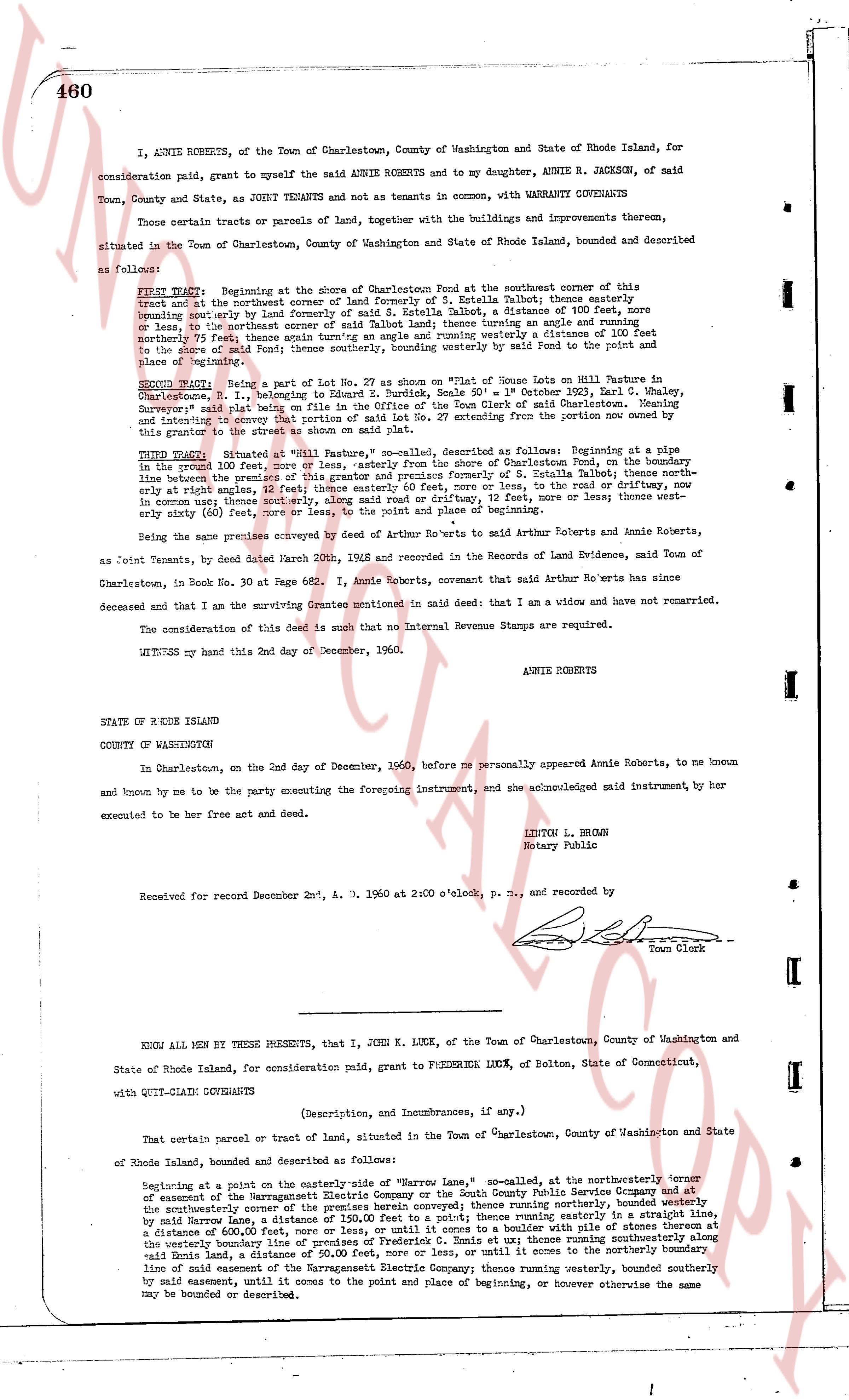
460
I, ANNIE ROBERTS, of the Town of Charlestown, County of Washington and State of Rhode Island, for consideration paid, grant to myself the said ANNIE ROBERTS and to my daughter, ANNIE R. JACKSON, of said Town, County and State, as JOINT TENANTS and not as tenants in common, with WARRANTY COVENANTS
Those certain tracts or parcels of land, together with the buildings and improvements thereon, situated in the Town of Charlestown, County of Washington and State of Rhode Island, bounded and described as follows:
FIRST TRACT: Beginning at the shore of Charlestown Pond at the southeasterly corner of this tract and at the northeast corner of land formerly of S. Estella Talbot; thence easterly bounding said tract by land of S. Estella Talbot, a distance of 100 feet, thence turning an angle and running south east corner of said Talbot land; thence turning an angle and running westerly a distance of 100 feet to the said Pond; thence running northerly by the shore of said Pond to the point and place of beginning
SECOND TRACT: Being a part of Lot No. 27 as shown on "Plat of Goose Hill Lots" on Rhode Island Chart No. 1, being on the property of E. Rundgren, Scale 50' = 1" October 1953, Karl C. Whaley, Surveyor's plat said plat being on file in the Office of the Town Clerk of said Charlestown. Noting and including the survey of the property of E. Rundgren, said survey being from the bottom line of the said grantor the street to the shore as shown on said plat.
THIRD TRACT: Situated at "Mill Road Pasture", Charlestown, described as follows: Beginning at a pine in the said 100 feet of land, being the distance from the shore of Charlestown Pond, on the boundary line between the premises of this grantor and premises formerly of S. Estella Talbot; thence northerly one hundred 100 feet, thence turning an angle and running east, 30 feet, to a post or nail or stone in common use; thence most easterly, along said road northerly, or driftway, 12 feet, more or less; thence westerly sixty (60) feet, more or less, to the point and place of beginning
The being name premises conveyed by deed of Arthur Roberts to wife Arthur Roberts and Jennie Roberts, as Joint Tenants, by deed dated March 20th, 1956 and recorded in the Records of Land Evidence, said Town of Charlestown, in Book No. 30 at Page 662. I, Annie Roberts, covenant that said Arthur Roberts has since deceased and that I am the surviving Grantee mentioned in said deed that I am a widow and have not remarried.
The consideration of this deed is such that no Internal Revenue Stamps are required.
WITNESS my hand this 2nd day of December, 60.
ANNIE ROBERTS
STATE OF RODE ISLAND
COUNTY OF WASHINGTON
In Charlestown, on the 2nd day of December, 1960, before me personally appeared Annie Roberts, to me known and known by me to be the party by executing the foregoing instrument, and she acknowledged said instrument, by her execute and be free her act and deed.
LEIGHTON L. BROWN
Notary Public
Received for record December 2nd, A. D. 1960 at 2:00 o'clock, p. m., and recorded by
[Signature]
Town Clerk
----
KNOW ALL MEN BY THESE PRESENTS, that I, JOHN K. LUCK, of the Town of Charlestown, County of Washington and State of Rhode Island, for consideration paid, grant to FREDERICK LUCK, of Belton, State of Connecticut, with QUIT-CLAIM COVENANTS
(Description, and Incumbrances, if any.)
That certain parcel or tract of land, situated in the Town of Charlestown, County of Washington and State of Rhode Island, bounded and described as follows:
Beginning at a point on the easterly line of the "Mirror Lane", so-called, at the northeasterly corner of easement of the Narragansett Electric Company or the South County Public Service Company and at the southeasterly corner of the premises herein conveyed above; thence running northeasterly, bounding easterly by said Mirror Lane, a distance of 100 feet, more or less; thence running easterly in a straight line, a distance of 600 feet, more or less, or until it comes to a boulder with a pile of stones thereon at the westerly boundary line of land of the South County Public Service Company; thence running southeasterly along said line a distance of 50,000 feet, more or less, or until it comes to the northerly boundary line of said easement, a distance of 50,000 feet, more or less, or until it comes to the northerly boundary line of said easement of the Narragansett Electric Company; thence running westerly, bounded southerly by said easement, until it comes to the point and place of beginning, or however otherwise the same may be bounded or described.
page 2 · read by Gemma vision
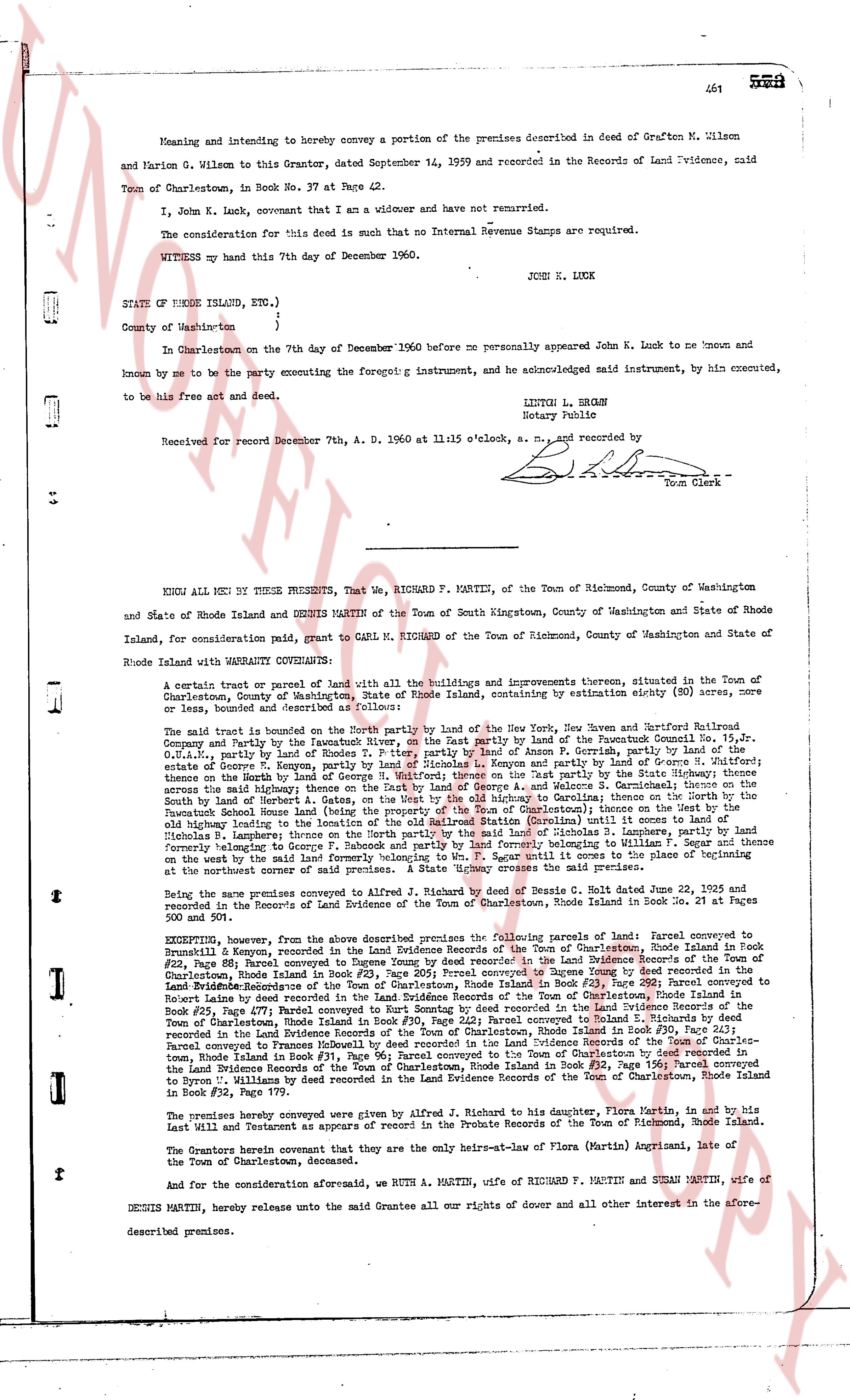
Meaning and intending to hereby convey a portion of the premises described in deed of Grafton M. Wilson
and Marion G. Wilson to this Grantor, dated September 14, 1959 and recorded in the Records of Land Evidence, said
Town of Charlestown, in Book No. 37 at Page 42.
I, John K. Luck, covenant that I am a widower and have not remarried.
The consideration for this deed is such that no Internal Revenue Stamps are required.
WITNESS my hand this 7th day of December 1960.
JOSH K. LUCK
STATE OF RHODE ISLAND, Etc.)
)
County of Washington )
In Charlestown on the 7th day of December 1960 before me personally appeared John K. Luck to me known and
known by me to be the party executing the foregoing instrument, and acknowledged said instrument, by him executed,
to be his free act and deed.
LILTON L. BROWN
Notary Public
Received for record December 7th, A. D. 1960 at 11:15 o'clock, a. m., and recorded by
Town Clerk
----
KNOW ALL MEN BY THESE PRESENTS, That We, RICHARD F. MARTIN, of the Town of Richmond, County of Washington
and State of Rhode Island and DENNIS MARTIN of the Town of South Kingstown, County of Washington and State of
Rhode Island, for consideration paid, grant to CARL M. RICHARD, of the Town of Richmond, County of Washington and State of
Rhode Island with WARRANTY CONVEYANCE:
A certain tract or parcel of land with all the buildings and improvements thereon, situated in the Town of
Charlestown, County of Washington, State of Rhode Island, containing by estimation eighty (80) acres, more
or less, bounded and described as follows:
The said tract is bounded on the North partly by land of the New York, New Haven and Hartford Railroad
Company and partly by the Favretto's land, on the East partly by land of the Pawcatuck Conn. Co. 15. Jr,
G.K.A. partly by land of Charles G. Favretto and partly by land of G. Favretto, on the South partly by the
estate of George K. Murphy, partly by land of Nicholas S. Kenyon and partly by land of George A. Walcott's heirs
across the said Mahogany street, thus on the East by land of George A. Walcott's heirs and partly by the
South by land of Charles G. Favretto, on the West partly by land of the New York, New Haven and Hartford Railroad
the Pawcatuck School house land (being the property of the Town of Charlestown) thence on the West by the
old fishing road, partly by land of the heirs of George A. Walcott and partly by land of the heirs of Nicholas
S. Lamprey; thence on the North partly by the said land of Nicholas S. Lamprey, thence by Lamprey, by land
formerly belonging to George A. Walcott, thence by land of G. Favretto, thence on the East by land of G. Favretto
thence on the work by the said land formerly belonging to v. [?] near Until it comes to the place of beginning
at the northest corner of said premises. A State highway crosses the said premises.
Being the same premises conveyed A. Richard by deed of Noah B. Davis of S. King. Rhode Island date June 22, 1925 and
recorded in the Records of Land Evidence of the Town of Charlestown, Rhode Island in Book 32 at Pages 500
and 501.
EXCEPTING, however, from the above described premises the following parcels of land: Parcel conveyed to
#22 Lamprey, being recorded in the Land Evidence Records of the Town of Charlestown, Rhode Island in Book
#22, Page 88; Parcel conveyed to Dungeon boy recorded in the Land Evidence Records of the Town of Charlestown,
Rhode Island in Book #22, Page 88; Parcel conveyed to Dungeon boy recorded in the Land Evidence Records of the
Land Evidence Records of the Town of Charlestown, Rhode Island in Book #23, Page 281; Parcel conveyed to
Robert Lunn recorded in the Land Evidence Records of the Town of Charlestown, Rhode Island in Book #23,
Book #25, Page 477; Parcel conveyed to Kurt Smutny recorded in the Land Evidence Records of the Town of
Charlestown, Rhode Island in Book #30, Page 243; Parcel conveyed to Kurt Smutny recorded in the Land Evidence
Records of the Land Evidence Records of the Town of Charlestown, Rhode Island in Book #30, Page 243;
Parcel conveyed to a Person recorded in the Land Evidence Records of the Town of Charlestown, Rhode Island in
Book #31, Page 96; Parcel conveyed to the Town of Charlestown by deed recorded in the
Land Evidence Records of the Town of Charlestown, Rhode Island in Book #32, Page 178; Parcel conveyed
to Byron U. Williams by deed recorded in the Land Evidence Records of the Town of Charlestown, Rhode Island
in Book #32, Page 179.
The premises hereby conveyed were given by Alfred J. Richard to his daughter, Flora Martin, and by his
Last Will and Testament as approved by respects in the Probate Records of the Town of Richmond, Rhode Island.
The Grantors herein covenant that they are the only heirs-at-law of Flora (Martin) Angizani, late of the
Town of Charlestown, deceased.
And for the consideration aforesaid, we RUTH A. MARTIN, wife of RICHARD F. MARTIN and SUSAN MARTIN, wife of
DENNIS MARTIN, hereby release unto the said Grantee all our rights of dower and all other interest in the afore-
described premises.
The page as recorded