The instrument's own words
page 1 · read by Gemma vision
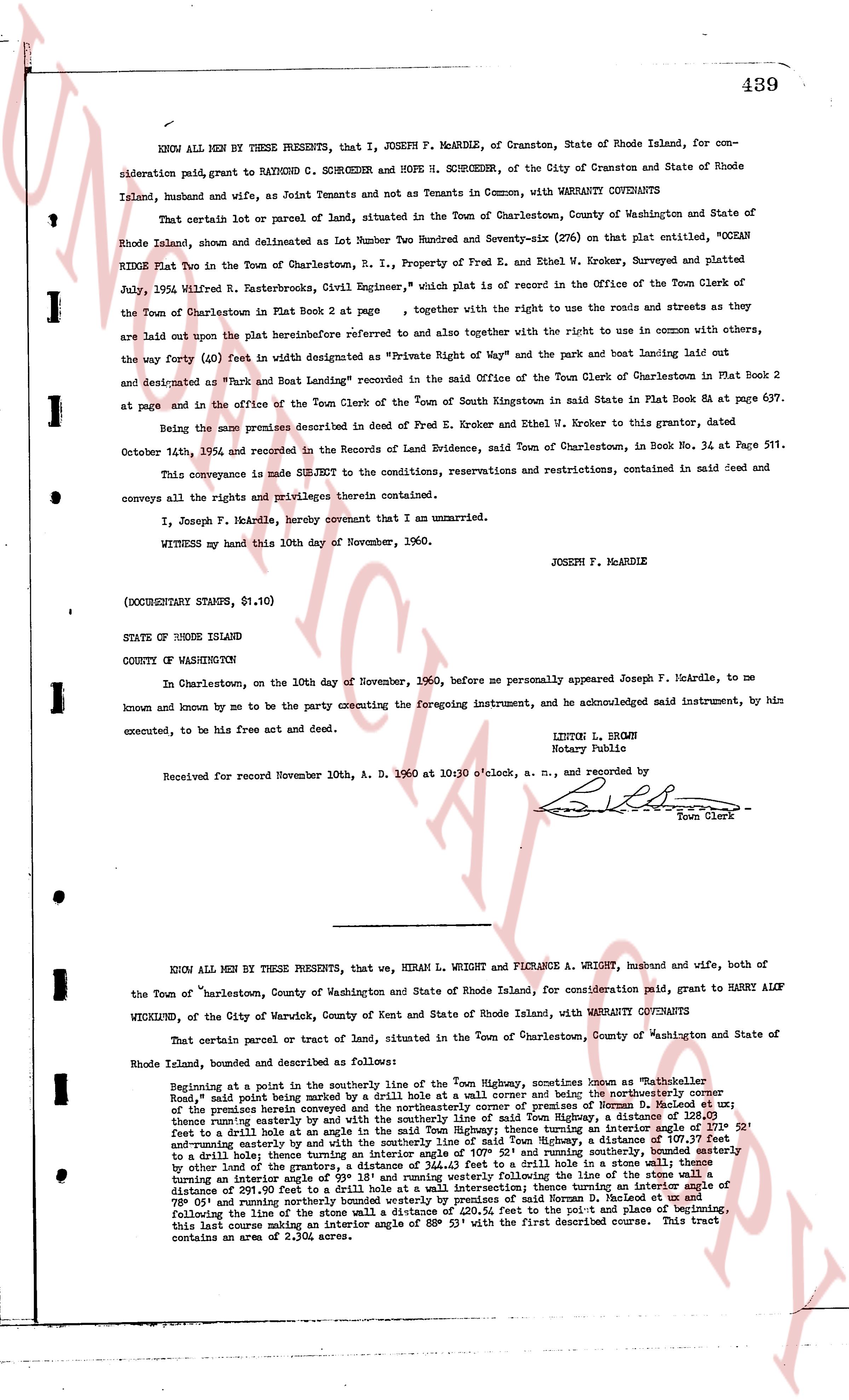
439
KNOW ALL MEN BY THESE PRESENTS, that I, JOSEPH F. MCARDLE, of Cranston, State of Rhode Island, for consideration paid, grant to RAYMOND C. SCHROEDER and HOPE H. SCHROEDER, of the City of Cranston and State of Rhode Island, husband and wife, as Joint Tenants and not as Tenants in Common, with WARRANTY COVENANTS
That certain lot or parcel of land, situated in the Town of Charlestown, County of Washington and State of Rhode Island, shown and delineated as Lot Number Two Hundred and Seventy-six (276) on that plat entitled, "OCEAN RIDGE Plat Two in the Town of Charlestown, R.I., Property of Fred E. Kroher, and Ethel W. Kroher, Surveyed and platted July, 1952 Wilfred R. Bakerstreets, City Wright Engineer," which plat is recorded in the Office of the Town Clerk of the Town of Charlestown in Plat Book 2 page [?], together with the right to use the roads and streets as they are laid out upon the plat hereinbefore referred to and also together with the right to use in common with others, the way forty (40) feet in width as designated as "Private Right of Way" and the park and boat landing laid out and designated as "Park and Boat Landing" recorded in the said Office of the Town Clerk of Charlestown in Plat Book 2 at page [?] and in the office of the Town Clerk of the Town of South Kingstown in said State in Plat Book 84 on page 637.
Being the same premises described in the deed of Fred E. Kroher and Ethel W. Kroher to this grantor, dated October 14th, 1952 and recorded in the Records of Land Evidence, said Town of Charlestown, in Book No. 34 at Page 511.
This conveyance is made SUBJECT to the conditions, reservations and restrictions, contained in said deed and conveys all the rights and privileges therefrom contained.
I, Joseph F. McArdle, hereby covenant that I am unmarried.
WITNESS my hand this 10th day of November, 1960.
JOSEPH F. MCARDLE
(DOCUMENTARY STAMPS, $1.10)
STATE OF RHODE ISLAND
COUNTY OF WASHINGTON
In Charlestown, on the 10th day of November, 1960, before me personally appeared Joseph F. McArdle, to me known and known by me to be the party executing the foregoing instrument, and he acknowledged said instrument, by him executed, to be his free act and deed.
LINTON L. BROWN
Notary Public
Received for record November 10th, A. D. 1960 at 10 o'clock a. m., and recorded by [signature] Town Clerk
----
KNOW ALL MEN BY THESE PRESENTS, that we, HIRAM L. WRIGHT and FLORENCE A. WRIGHT, husband and wife, both of the Town of Charlestown, County of Washington and State of Rhode Island, for consideration paid, grant to HARRY ALOY WICKEND, of the City of Warwick, County of Kent and State of Rhode Island, with WARRANTY COVENANTS
That certain parcel or tract of land, situated in the Town of Charlestown, County of Washington and State of Rhode Island, bounded and described as follows:
Beginning at a point in the southerly line of the Town Highway, sometimes known as "Whale-tailer Road," said point being marked by a drill hole at a wall corner and being in the northeasterly corner of the premises herein conveyed and being in the premises of Norman D. McArdle et al; thence running easterly by and with the southerly line of said Town Highway, a distance of 128.00 feet to a drill hole at a wall corner; thence turning northerly a distance of 2.00 feet to a turning at an interior angle of 90° and running easterly by and with the southerly line of said Town Highway, a distance of 109.77 feet to a drill hole at a wall corner; thence turning northerly a distance of 2.00 feet to a turning at an interior angle of 90° by land of the grantors, a distance of 344.43 feet to a drill hole in a stone wall; thence turning northerly an interior angle of 90° and running easterly along the line of the stone wall, by land of the grantors, a distance of 297.90 feet to a drill hole at a wall intersection; thence turning an interior angle of 90° and running northerly by land of the grantors and said Norman D. McArdle et al, a distance of 339.00 feet following the line of the stone wall a distance of 250.24 feet to the point and place of beginning, this last course making an interior angle of 88° 53' with the first described course. This tract contains an area of 2.394 acres.
The page as recorded