The instrument's own words
page 1 · read by Gemma vision
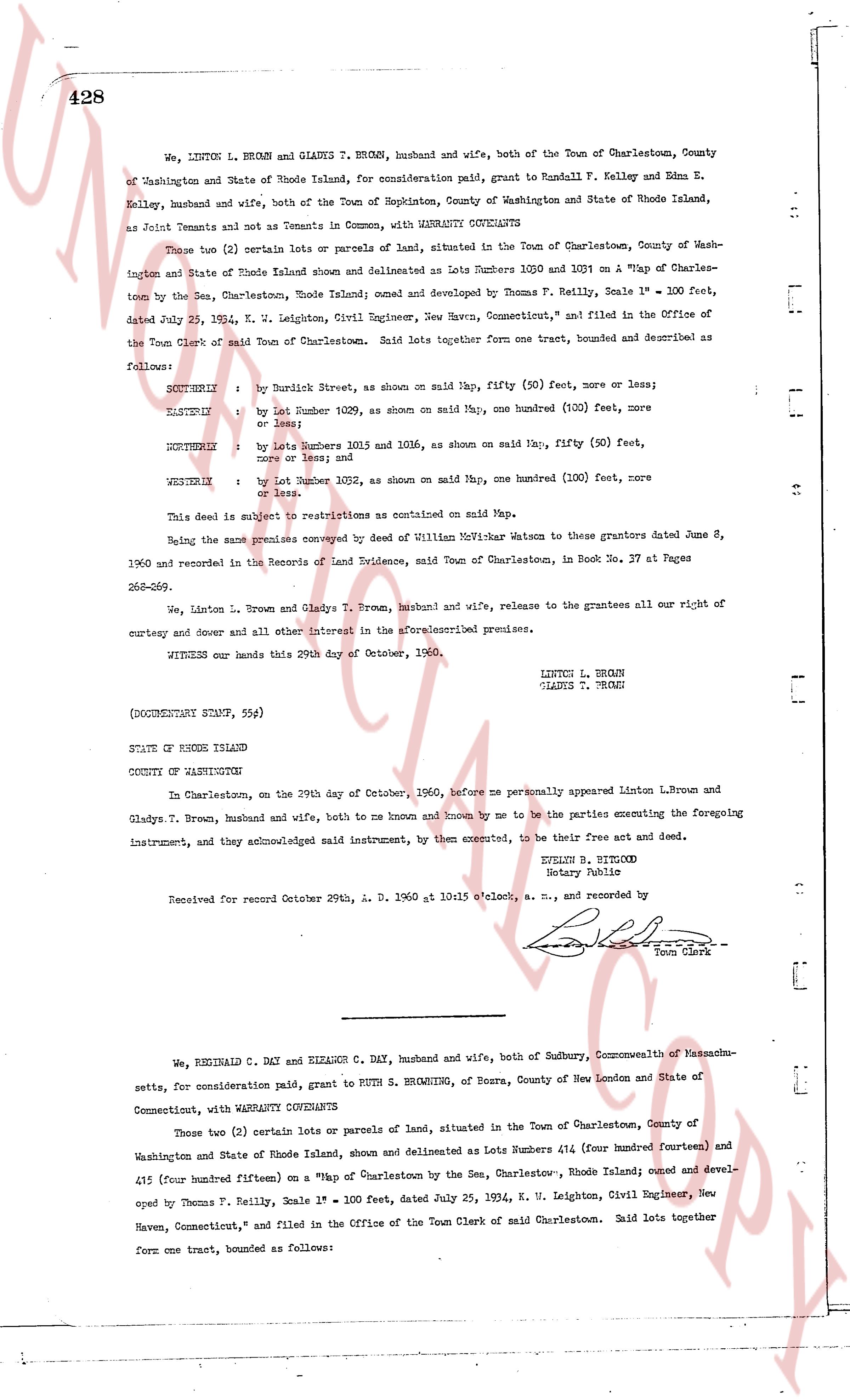
428
We, LINTON L. BROWN and GLADYS T. BROWN, husband and wife, both of the Town of Charlestown, County of Washington and State of Rhode Island, for consideration paid, grant to Randall F. Kelley and Edna E. Kelley, husband and wife, both of the Town of Hopkinton, County of Washington and State of Rhode Island, as Joint Tenants and not as Tenants in Common, with WARRANTY COVENANTS
Two (2) certain lots or parcels of land, situated in the Town of Charlestown, County of Washington and State of Rhode Island shown and delineated as Lots Numbers 1030 and 1031 on "a Map of Charlestown by the Sen, Charlestown, Rhode Island; owned and developed by Thomas F. Reilly, Scale 1" = 100 feet, dated July 23, 1934, N. W. Leighton, Civil Engineer, New Haven, Connecticut," and filed in the Office of the Town Clerk of said Town of Charlestown. Said lots together form one tract, bounded and described as follows:
SOUTHEAST by Burdick Street, as shown on said Map, fifty (50) feet, more or less;
EASTSIDE by Lot Number 1029, as shown on said Map, one hundred (100) feet, more or less;
NORTHEAST by Lots Numbers 1031 and 1036, as shown on said Map, fifty (50) feet, more or less and measured
WESTSIDE by Lot Number 1032, as shown on said Map, one hundred (100) feet, more or less.
This deed is subject to restrictions as contained on said Map.
Being the same premises conveyed by Deed of William Notifier Watson to these grantors dated June 8, 1960 and recorded in the Records of Land Evidence, said Town of Charlestown, in Book No. 37 at Pages 263-269.
We, Linton L. Brown and Gladys T. Brown, husband and wife, release to the grantees all our right of curtesy and dower and all other 29th interest in the aforementioned premises.
WITNESS our hands this 29th day of October, 1960.
LINTON L. BROWN
GLADYS T. BROWN
(DOCUMENTARY STAMP, 55¢)
STATE OF RHODE ISLAND
COUNTY OF WASHINGTON
In Charlestown, on the 29th day of October, 1960, before me personally appeared Linton L. Brown and Gladys T. Brown, husband and wife, both to me known and known by me to be the parties executing the foregoing instrument, and they acknowledged said instrument by them executed, to be their free act and deed.
EVELYN B. BITLWOOD
Notary Public
Received for record October 29th, A. D. 1960 at 10:15 o'clock, a. m., and recorded by
[Signature]
Town Clerk
----
We, REGINALD C. DAY and ELEANOR C. DAY, husband and wife, both of Sudbury, Commonwealth of Massachusetts, for consideration paid, grant to RUTH S. BROWNING, of Bourne, County of New London and State of Connecticut, with WARRANTY COVENANTS
Two (2) certain lots or parcels of land, situated in the Town of Charlestown, County of Washington and State of Rhode Island, shown and delineated as Lot Numbers 414 (four hundred fourteen) and 415 (four hundred fifteen) on "a Map of Charlestown by the Sen, Charlestown, Rhode Island; owned and developed by Thomas F. Reilly, Scale 1" = 100 feet, dated July 23, 1934, N. W. Leighton, Civil Engineer, New Haven, Connecticut," and filed in the Office of the Town Clerk of said Town of Charlestown. Said lots together form one tract, bounded as follows:
page 2 · read by Gemma vision
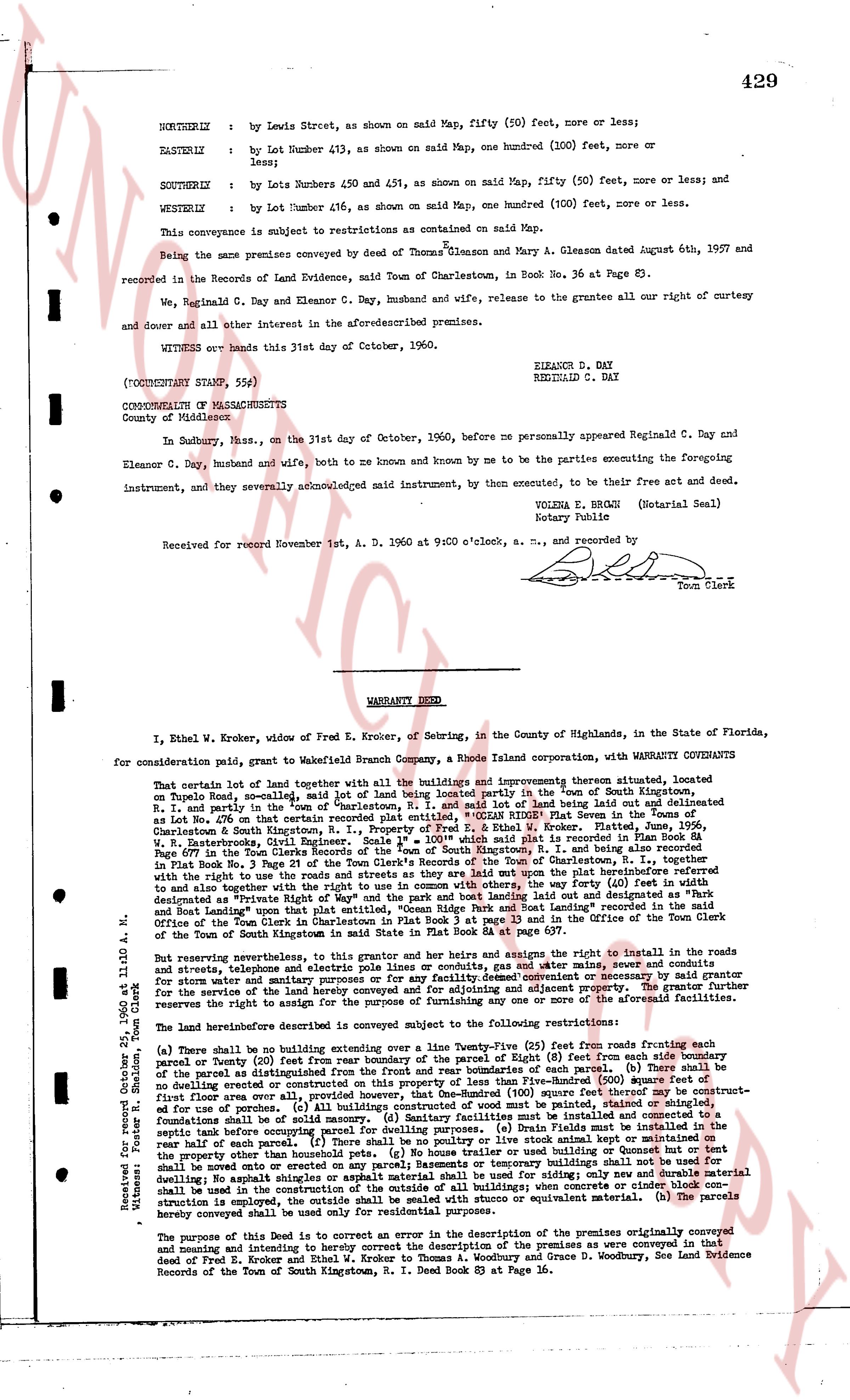
429
NORTHERLY : by Lewis Street, as shown on said map, fifty (50) feet, more or less;
EASTERLY : by Lot Number 413, as shown on said Map, one hundred (100) feet, more or less;
SOUTHERLY : by Lots Numbers 450 and 451, as shown on said map, fifty (50) feet, more or less; and
WESTERLY : by Lot Number 416, as shown on said Map, one hundred (100) feet, more or less.
This conveyance is subject to restrictions as contained on said Map.
Being the same premises conveyed by deed of Thomas Gleason and Mary A. Gleason dated August 6th, 1927 and recorded in the Records of the Land Evidence, said Town of Charlestown, in Book no. 36 at Page 83.
We, Reginald C. Day and Eleanor C. Day, husband and wife, release to the Grantee all our right of curtesy and dower and all other interest in the aforesaid premises.
WITNESS our hands this 31st day of October, 1960.
ELEANOR C. DAY
REGINALD C. DAY
(NOTARY STAMP, seal)
COMMONWEALTH OF MASSACHUSETTS
County of Washington
In Sudbury, Mass., on the 31st day of October, 1960, before me personally appeared Reginald C. Day and Eleanor C. Day, husband and wife, both to me known and known by me to be the parties executing the foregoing instrument, and they severally acknowledged said instrument, by them executed, to be their free act and deed.
VOLENA E. BROWN (Notarial Seal)
Notary Public
Received for record November 1st, A. D. 1960 at 9 o'clock, a. m., and recorded by
[Signature]
Town Clerk
----
WARRANTY DEED
I, Ethel W. Kroker, widow of Fred E. Kroker, of Sebring, in the County of Highlands, in the State of Florida, for consideration paid, grant to Wakefield Branch Company, a Rhode Island corporation, with WARRANTY COVENANTS
That certain lot of land including together with all the buildings and improvements thereon situated, located on Dupont Road, so called, said lot of land being partly located in the Town of South Kingstown, R. I. and partly in the "town" of Charlestown, R. I. and more particularly described as follows: "A lot created in Lot No. 60 of that certain tract of land known as the "CEDAR RIDGE" Plat Seven in the Town of Charlestown & South Kingstown, R. I., property of Fred E. & Ethel W. Kroker, Platted, June, 1956, in Plat Book 13 page 13 of the Town Clerk's Records of the Town of South Kingstown, R. I. and being also recorded in Plat Book No. 1 of the Town Clerk's Records of the Town of Charlestown, R. I. and being also recorded in Plat Book No. 1 page 3 of the Town Clerk's Records of the Town of Charlestown, R. I. and being also recorded with the right to use the roads and streets as they are laid out upon the plat before the partitioning referred to and also together with the right to use the roads and streets, the way forty (40) feet wide, and the way called "designated as Private Right of Way" and the park space laid out bounding land and described as that part of the land together with the right to use the roads and streets, the way forty (40) feet wide, as recorded in the Office of the Town Clerk in Charlestown in Plat Book 1 at page 13 and in the Office of the Town Clerk of the Town of South Kingstown in Plat Book 13 at page 13."
But reserving appropriations, this grantor, and her heirs and assigns the right to install in the roads and streets, shoreways and telephone electric or pole lines and conduits, gas and water mains, sewer, and conduits for storm waters, and to maintain the same, and to have the right to enter upon the said roads and streets for the purpose of making necessary service of the land hereby conveyed and for adjusting and an easing of aforesaid facilities. The reserve interests the road the reserve the rights to install for the purpose of improving any one or more of the above facilities.
The land hereinabove described is conveyed subject to the following, five restrictions:
(a) There shall be no building extending over the land within twenty (20) feet from roads fronting such lots (b) There shall be no fence or other structure extending over the boundary of the Right (8) feet from each side boundary of the parcel as fronted from the street without the consent in writing of said parcel (c) There shall be no building over Five-Hundred (500) square feet of first floor area as originally provided, that however, One-Hundred (100) square feet there among shall be permitted for first floor area of garage, storage room, porch, etc. (d) All buildings shall be painted, shingled or finished foundations shall be of solid masonry. (e) Sanitary facilities must be installed and constructed in accordance with the rules and regulations of the State of Rhode Island. Fields must be installed in the rear half of each parcel. (f) There shall be no poultry or live stock animal stall kept or maintained on any parcel (g) No business or commercial activity shall be conducted on any parcel building shall not be used to move onto or constructed on any parcel) Remnants or temporary buildings shall not be used for any purpose other than during the construction of a permanent building, and no temporary building shall be moved onto or constructed on any parcel) requirements on concrete or cinder block construction shall be used in the construction of the outside of all buildings; when concrete or cinder block construction is required it shall be of the best quality of concrete or equivalent material. (h) The parcels hereby conveyed shall be used only for residential purposes.
The purpose of this Deed is to correct an error in the description of the premises as conveyed in the deed dated May 5, Kroker and Kroker to Thomas A. Woodley and Grace D. Woodley, see Land Evidence Records of the Town of South Kingstown, R. I. Town Deed Book 3 at Page 86.
Witnessed: Foster R. Sheldon, Town Clerk
this 25th day of May, 1960 at 11:00 A. M.
The page as recorded