The instrument's own words
page 1 · read by Gemma vision
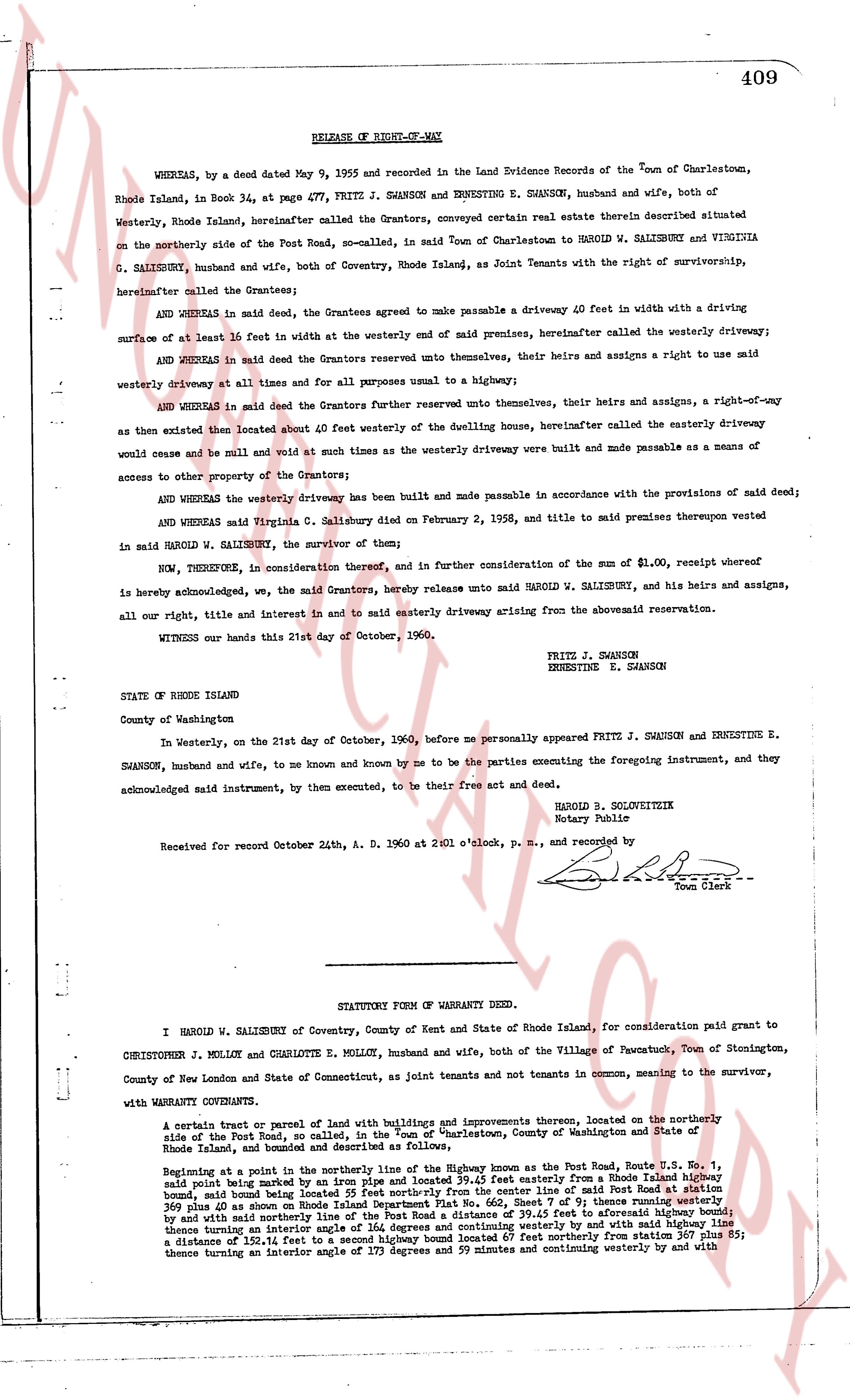
409
RELEASE OF RIGHT-OF-WAY
WHEREAS, by a deed dated May 9, 1955 and recorded in the Land Evidence Records of the Town of Charlestown, Rhode Island, in Book 34, at page 477, FRITZ J. SWANSON and ERNESTINE E. SWANSON, husband and wife, both of Westerly, Rhode Island hereinafter called the Grantors, conveyed certain real estate therein described situated on the northerly side of the Post Road, so-called, in said Town of Charlestown to HAROLD W. SALISBURY and VIRGINIA C. SALISBURY, husband and wife, both of Coventry, Rhode Island, as Joint Tenants with the right of survivorship, hereinafter called the Grantees;
AND WHEREAS in said deed, the Grantees agreed to make passable a driveway 40 feet in width with a driving surface of at least 16 feet in width at the westerly end of said premises, hereinafter called the westerly driveway;
AND WHEREAS in said deed the Grantors reserved unto themselves, their heirs and assigns a right to use said westerly driveway at all times and for all purposes until all for purposes unnamed to a highway;
AND WHEREAS in said deed the Grantors further reserved unto themselves, their heirs and assigns, a right-of-way as then existed then located about 40 feet westerly of the dwelling house, hereinafter called the easterly driveway would cease and be null and void at such times as the westerly driveway were built and made passable as a means of access to other property of the Grantors;
AND WHEREAS the westerly driveway has been built and made passable in accordance with the provisions of said deed;
AND WHEREAS said Virginia C. Salisbury died on February 2, 1958, and title to said premises therefore vested in said HAROLD W. SALISBURY, the survivor of them;
NOW, THEREFORE, in consideration therefore, and in further consideration of the sum of $1.00, receipt whereof is hereby acknowledged, we, the said Grantors, hereby release unto said HAROLD W. SALISBURY, and his heirs and assigns, all our right, title and interest in and to said easterly driveway arising from the abovementioned reservation.
WITNESS our hands this 21st day of October, 1960.
FRITZ J. SWANSON
ERNESTINE E. SWANSON
STATE OF RHODE ISLAND
County of Washington
In Westerly, on the 21st day of October, 1960, before me personally appeared FRITZ J. SWANSON and ERNESTINE E. SWANSON, husband and wife, to me known and by me to be the parties executing the foregoing instrument, and they acknowledged said instrument, by them executed, to be their free act and deed.
HAROLD B. SOLOVEITZEK
Notary Public
Received for record October 24th, A. D. 1960 at 2:01 o'clock, p. m., and recorded by
[Signature]
Town Clerk
----
STATUTORY FORM OF WARRANTY DEED.
I HAROLD W. SALISBURY of Coventry, County of Kent and State of Rhode Island, for consideration paid grant to CHRISTOPHER J. MOLLOY and CHARLOTTE E. MOLLOY, husband and wife, both of the Village of Pawcatuck, Town of Stonington, County of New London and State of Connecticut, as joint tenants and not tenants in common, meaning to the survivor,
with WARRANTY CONVEYANCE.
A certain tract of parcel of land with buildings and improvements thereon, located on the northerly side of the Post Road, so called, in the town of "Charlestown", County of Washington and State of Rhode Island, lands, and bounded and described as follows:
Beginning at a point in the northerly line of the highway known as the Post Road, Route 1, S.E. Vol. 1, said point being marked by an iron pin and located 59.45 feet easterly from a Rhode Island highway bound, said bound being located 25 feet northerly from the center line of said Post Road at station 369 plus 40 as shown on Rhode Island Department Plat No. 660, and 17 ft 8 in. northerly from the highway line and with said marker and the Rhode Island highway bound, 59.45 feet to associated highway bound; thence turning an interior angle of 164 degrees and continuing westerly by and with said highway line a distance of 152.14 ft. a second iron pin; thence turning an interior angle of 111 degrees northerly from 367 plus 85; thence turning an interior angle of 173 degrees and 59 minutes and continuing westerly by and with
page 2 · read by Gemma vision
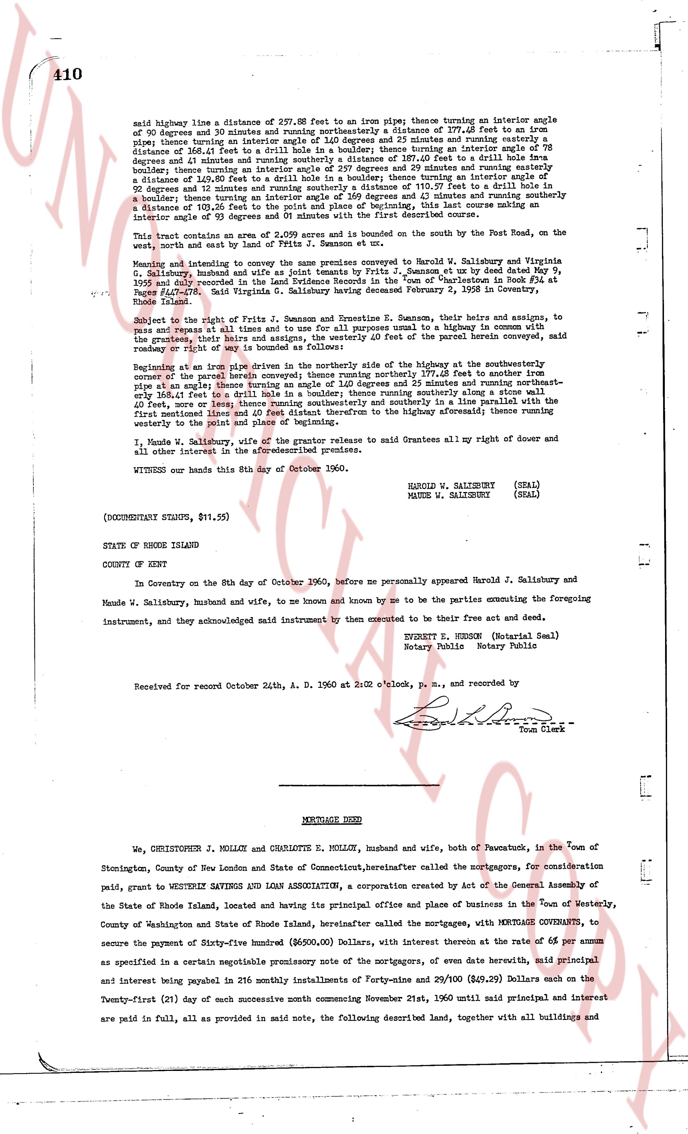
said highway line a distance of 237.88 feet to an iron pipe thence turning an interior angle of 90 degrees and 39 minutes and running northeasterly a distance of 377.68 feet to an iron pipe thence turning an interior angle of 120 degrees and 23 minutes and running easterly a distance of 166.41 feet to a drill hole in a boulder thence turning an interior angle of 78 degrees and 31 minutes and running southeasterly a distance of 397.40 feet to a drill hole in a boulder thence turning an interior angle of 257 degrees and 29 minutes and running easterly a distance of 148.78 feet to an iron pipe thence turning an interior angle of 111 degrees and 52 minutes and turning a distance of 103.26 feet to the point and place of beginning, this last course making an interior angle of 93 degrees and 59 minutes with the first described course.
This said parcel consists of .202 acres and is bounded on the south by the Post Road, on the west, north and east by land of Prima J. Jamison et ux.
Meaning and intent to convey the same premises conveyed to Harold W. Salisbury and Maude W. Salisbury by Prima J. Jamison and [?] Jamison, et ux by deed dated May 9, 1935 and recorded in the Land Evidence Records in the "Town of Charlestown Book RL Plat 407 Page 478" Said Virginia G. Salisbury having deceased February 2, 1958 in Coventry, Rhode Island.
Subject to the right of Prima J. Jamison and Ernestine R. Jamison, their heirs and assigns, to pass and repass at all times and to use for purposes all usual and customary highways in common with the grantors, their heirs and assigns, and to use the [?] of the above described land for a side roadway or right of way by road bounded as follows:
Beginning at an iron pipe driven in the northerly side of the highway at the southeasterly corner of the parcel herein described and running northerly 177.68 feet to another iron pipe at an angle; thence running an angle of 1.40 degrees and 25 minutes and running northeasterly one half foot to a drill hole in a boulder; thence running southeasterly along a stone wall 40 feet, more or less thence running southeasterly and in a solute line parallel with the first mentioned line and distance 177.68 feet from to the highway aforesaid; thence running westerly to the point and place of beginning.
I, Maude W. Salisbury, wife of the grantor release to said Grantees all my right of dower and all other interest in the aforesaid premises.
WITNESS our hands this 8th day of October 1960.
HAROLD W. SALISBURY (SEAL)
MAUDE W. SALISBURY (SEAL)
(DOCUMENTARY STAMPS, $11.55)
STATE OF RHODE ISLAND
COUNTY OF KENT
In Coventry on the 8th day of October 1960, before me personally appeared Harold J. Salisbury and Maude W. Salisbury, husband and wife, to me known and known by me to be the parties executing the foregoing instrument, and they acknowledged said instrument by them executed to be their free act and deed.
SYLVIA E. HERSON (Notarial Seal)
Notary Public Notary Public
Received for record October 24th, A. D. 1960 at 2:02 o'clock, p. m., and recorded by [Signature]
Town Clerk
----
MORTGAGE DEED
We, CHRISTOPHER J. MOLLOY and CHARLOTTE E. MOLLOY, husband and wife, both of Newcutuck, in the town of Stonington, County of New London and State of Connecticut, hereinafter called the mortgagors, for consideration paid, grant to WESTERLY SAVINGS AND LOAN ASSOCIATION, a corporation created by Act of the General Assembly of the State of Rhode Island, located and having its principal office and place of business in the town of Westerly, County of Washington and State of Rhode Island, hereinafter called the mortgagees, with MORTGAGE COVENANTS, to secure the payment of Sixty-five hundred Dollars ($6,500.00) Dollars, with interest thereon at the rate of 6% per annum as specified in a certain negotiable promissory note of the mortgagors, of even date herewith, said principal and interest being payable in 216 monthly installments of Forty-nine & 29/100 ($49.29) Dollars each on the Twenty-first (21) day of each successive month commencing November 21st, 1960 until said principal and interest are paid in full, all as provided in said note, the following described land, together with all buildings and
The page as recorded