The instrument's own words
Attribution under review. The portal's file number is shared by more than one instrument, and the words below could not be placed with certainty on this one by their own evidence (page stamp, parties, dates); they may belong to a neighbouring instrument. Read them as the record of the page, not yet as this deed's own.
page 1
105
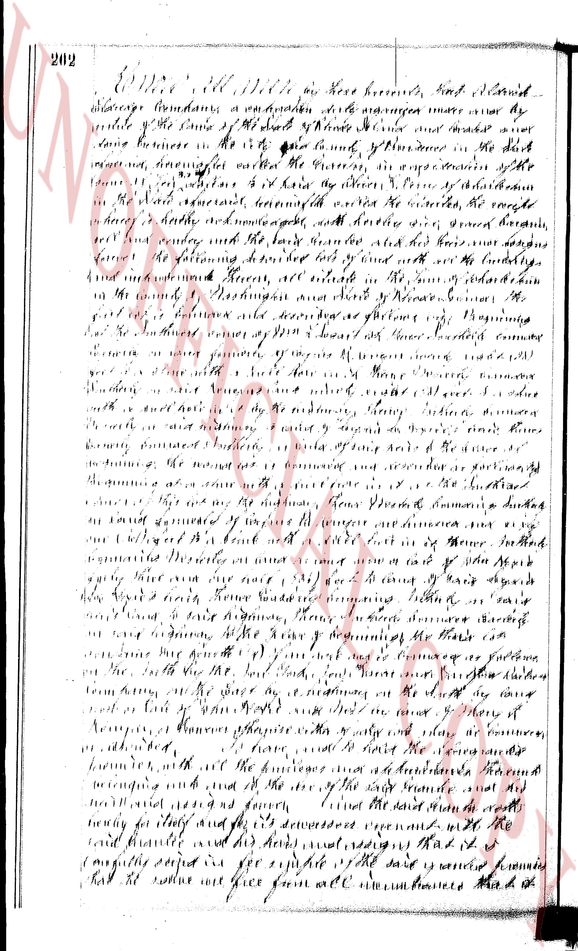
KNOW ALL MEN BY THESE PRESENTS: That We, GEORGE T. FINER and CORDELIA F. FINER, husband and wife, of
South Kingstown, Rhode Island, hereinafter called the "mortgagors," in consideration of One Thousand One Hundred Five Hundred
& 00/100 ($1,105.00) Dollars, to us paid by INDUSTRIAL NATIONAL BANK of Providence, a national banking association
organized and existing under the laws of the United States of America, with its principal place of business in the
City and County of Providence in the State of Rhode Island, hereinafter called the "mortgagee," the receipt whereof
is hereby acknowledged, do hereby grant to the mortgagee, its successors and assigns forever, with MORTGAGE COVENANTS,
to secure the payment of the principal and interest of a certain promissory note due of the mortgagor of even date here-
with and being the several sums described below, the following:
That certain lot or piece of land, together with the buildings and other improvements thereon,
situated in the Town of Charlestown, County of Washington and State of Rhode Island, house-
and described as follows:
BEGINNING at a point in the northerly line of North Route 81, Rhode Island, being marked by an iron
pipe and being the southeasterly corner of the tract herein described and the northeasterly
corner of lot No. 5 on a plan recorded in Charlestown Land Evidence Book 14, Page 1, "Eighties Heights,
Charlestown, R.I., Scale 1 inch equals 40 feet, July 15, 1959, by E. A. Ransier, Civil Engineer,"
recorded in the Charlestown Land Evidence Recording district; thence running easterly along said northerly line by the
shortest distance to the northeasterly corner of lot No. 5, being marked by an iron pipe set at a distance of 156.11 feet;
thence running an interior angle of 270° 34' and running southerly by an offset with the easterly line
of North Route 81, being marked by an iron pipe set at a distance of 232.05 feet;
thence running northerly southeasterly bounded then southerly by Lot No. 7 on said plan a distance of 227.06 feet;
thence running an interior angle of 270° 34' and running westerly by an offset with the westerly line of said
fence; thence running an interior angle of 89° 41' and running southeasterly bounded northeasterly
by Lot No. 5 on said plan a distance of 156.11 feet to the point of beginning, the above described
last course making an interior angle of 90° 00' with the first described course. The above
described tract containing 0.33 acres more or less (See Exhibit B).
Being the same premises conveyed to the mortgagors by the deed from Ralph Reale Corporation,
recorded in said TOWN; together with the rights and SUBJECT to the conditions described therein.
This mortgage is made upon the STATUTORY CONDITION and with the STATUTORY FORM of G.L.O.I.s. proviso, however,
that no redemption of a part of the premises shall be allowed, nor a public sale mandated in the city or county, in the
City of Providence, and that a foreclosure sale may be held upon the premises or elsewhere at the option of the
mortgagee, as specified in said notice.
This mortgage is made upon the further condition that if those additional covenants and agreements contained in a STATEMENT
OF COVENANTS AND AGREEMENTS, a copy thereof having been this day received by the mortgagor, the receipt whereof is
hereby acknowledged, the exact terms of which are set forth in said Statement and incorporated herein by reference as if
fully set forth herein, and which covenants and agreements made part of this mortgage or the default shall be made in the
performance or observance of any of the same, it shall be lawful for the mortgagee to sell the above described
premises pursuant to as aforesaid.
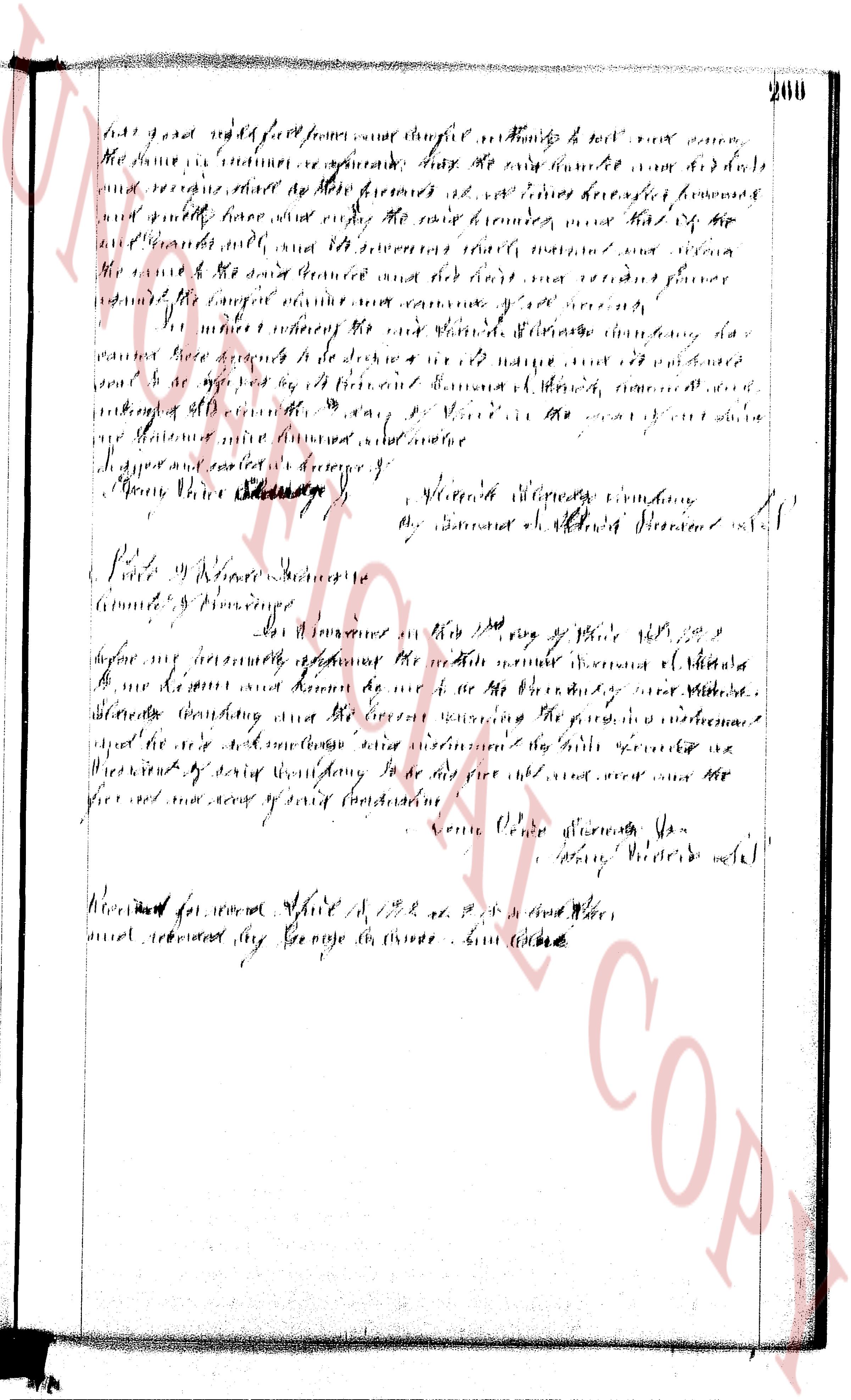
And for the consideration aforesaid, we, said mortgagors, release to the mortgagee all right of dower(s)
(curtesy) and all other rights, statutory or otherwise, in the aforementioned premises.
IN WITNESS WHEREOF, the mortgagors have executed these presents on the 13th day of October, 1960
GEORGE T. FINER
CORDELIA L. FINER
Executed in presence of
Harold B. Soloveitzik
INDIVIDUAL ACKNOWLEDGMENT
STATE OF RHODE ISLAND
COUNTY OF WASHINGTON
In Westerly on the 13th day of October, 1960, before me personally appeared the above named GEORGE T. FINER
and CORDELIA FINER, to me and known by me to be the parties executing the foregoing instrument and acknowledged
said instrument by them executed to be their free act and deed.
HAROLD B. SOLOVEITZIK
Notary Public
Received for record October 14th, A. D. 1960 at 9:21 o'clock, a. m., and recorded by
Town Clerk
DISCHARGE OF MORTGAGE
Industrial National Bank of Rhode Island, having received full payment and satisfaction of the within
mortgage, recorded in the (Land Evidence) (Real Estate Mortgage Records) in the Town of Charlestown, R. I.
in Kingstown Book, 37 at page 405, does hereby cancel and discharge the same, and covenants to and with
the person(s) signed above that the same is fully paid.
IN TESTIMONY WHEREOF said Industrial National Bank of Providence has caused these presents to be signed
and its corporate seal to be hereto annexed by its proper officers or representatives thereby authorized,
this 11th day of July, A. D. 1967.
INDUSTRIAL NATIONAL BANK of Rhode Island (Corporate Seal)
By C. Albert Selbinger, Vice President
C. Albert Selbinger, Vice Manager
By Lillian C. Mae
Lillian C. Mae, Assistant Manager
Witness:
Alma N. Rhodes
Received for record July 15th, A. D. 1967 at 10:00 o'clock, a. m., and recorded by
Town Clerk
page 2
351
Parcel 2. A certain tract of land situated in South Kingstown, County
of Washington, State of Rhode Island, containing nine acres, one hundred
twenty-three and a half rods more or less, bounded as follows: beginning at
the southwest corner of a road known as the East Road and at a line now or
formerly of Welcome H. Kenyon; thence westerly boundary by said south
East Road and roads thence southeasterly boundary by said south
East Road and roads thence southerly boundary by said
formerly of Asa Church twenty-six and a half rods; thence easterly parallel
with said East Road and roads thence northerly boundary by said
Asa Church 54 rods church road to now or formerly of Welcome H. Kenyon;
thence southerly boundary enclosing by said Welcome H. Kenyon 26 1/2 rods to
the pillar of boundary of the aforementioned parcel which corner is marked by a crosser
by deed of Samuel D. Davis & Hosea and Horace E. Burdick dated May 9, 1933 and re-
corded in the records of land evidence of said South Kingstown in Book 5,
P. 435.
Parcel 3. That certain real estate situated in Charlestown, County of
Washington, in the State of Rhode Island and described as follows: Lot
No. 1 in Block A on that section of Lots at Herberts' Harbor, Charlestown, R. I.,
owned by Thomas W. Arnold, dated Sept. 14, 1903, T. S. ______,
Surveyor on file in Town Clerk's office, Charlestown, R. I., and it is bounded
as follows: beginning at a stone wall and pole and said pole is 100 feet
separating it from land formerly of Isaac T. Prosser and Forty (40) feet from the a
djoining land in said wall and pole and said pole is 100 feet north of the
J. P. Thorne; thence easterly boundary continuing by harbor Road, so called, and
one hundred and fifty feet to a stone wall; thence southerly boundary by harbor
bor Road and Thorne Road so called; thence southerly boundary by
said Thorne Road fifty (50) feet to a stone wall; thence northerly boundary by
easterly by Lot No. 2 and similarly on said plat one hundred and fifty (150) feet to
said stone wall at land formerly of said Prosser; thence southerly boundary
westerly by said wall 100 feet to the pole of beginning, and containing about
7500 square feet; being the same property and easements conveyed to Isaac T.
Prosser by deed of Ezra and Sarah ______, J. Watts dated Sept. 14, 1903
1929 and recorded in the records of land evidence of said Charlestown in
Book 2, P. 411.
The grantor further grants to said grantees for a period of two years following the
execution of this instrument the reasonable use of the well situated near the farm buildings
westerly of Parcel 1 and located north of the Post Road between said road and the three-car
garage.
All of the above described property conveyed by this deed being a portion of the
property formerly owned by Isaac T. Prosser, late of said Charlestown, and the premises herein
conveyed being two of the three (3) parts thereof, as divided by agreement between Harold T.
Prosser, George H. Prosser, and Rufus H. Prosser, the sole heirs at law of the said Isaac T.
Prosser.
TO HAVE AND TO HOLD the afore-granted premises, except the well, with all the rights,
privileges and appurtenances thereto belonging unto and to the use of the said grantees and their
heirs and assigns forever.
And the said grantor, except as to Parcels 6, 7 and 8 as to which only quitclaim
covenants attach, does hereby, for himself and for his heirs, executors and administrators, cove-
nant with the said grantees and their heirs and assigns that he is lawfully seized in fee simple
of said granted premises; that the same are free from all incumbrances; that he has good right,
full power and lawful authority to sell and convey the same in manner as aforesaid, that the said
grantees and their heirs and assigns, shall by these presents at all times hereafter peacefully
and quietly have and enjoy the said premises, and that he, the said grantor will, and his heirs,
executors, and administrators, shall warrant and defend the same to the said grantees and their
heirs and assigns forever against the lawful claims and demands of all persons.
And for the consideration aforesaid LAURA W. PROSSER does release all her right of
dower in and to the said granted premises unto the said grantees and their heirs and assigns,
forever.
IN WITNESS WHEREOF, we have hereunto set our hands and seals this 1st day of Oct , in
the year of our Lord one thousand nine hundred and forty.
Executed in the presence of:
CHARLES ____ MAI
Notary Public
By Commission expires Jan. 30, 1942.
HAROLD T. PROSSER (SEAL)
LAURA W. PROSSER (SEAL)
(INTERNAL REVENUE STAMPS $6.60)
The page as recorded