The instrument's own words
page 1 · read by Gemma vision
875
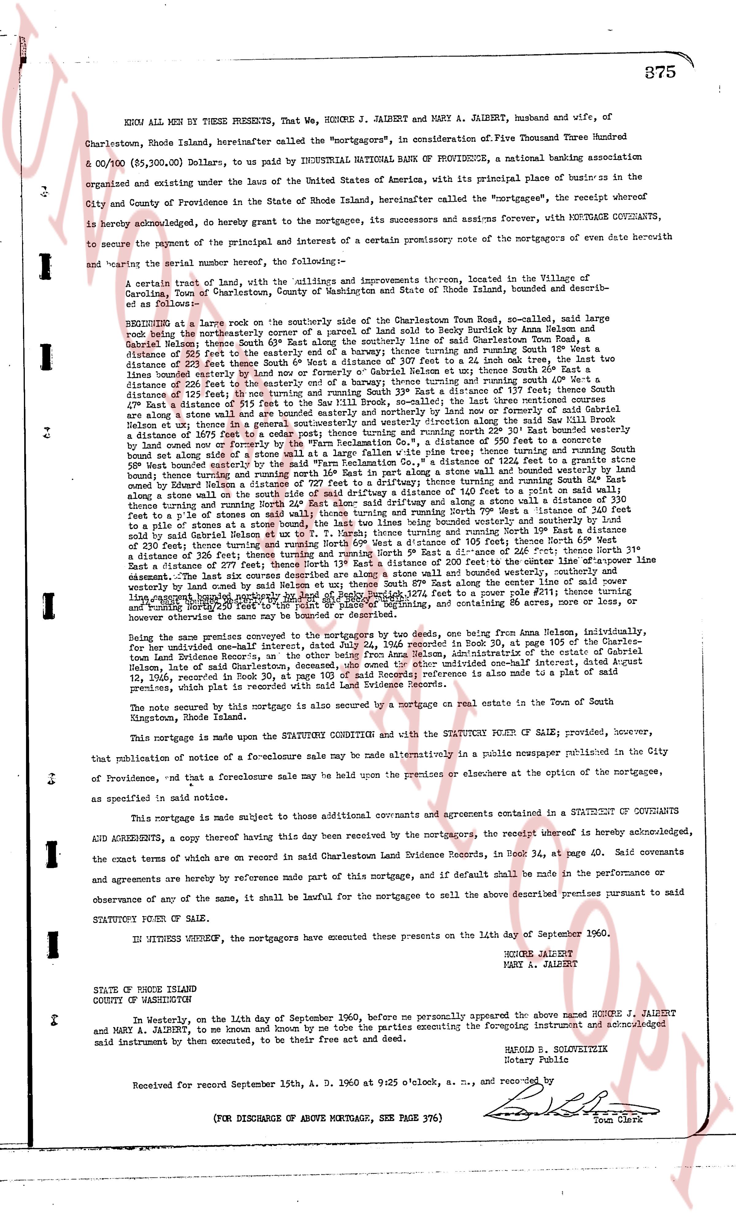
KNOW ALL MEN BY THESE PRESENTS, That We, HONORE J. JALBERT and MARY A. JALBERT, husband and wife, of Charlestown, Rhode Island, hereinafter called the "mortgagors", in consideration of Five Thousand Three Hundred & 00/100 ($5,300.00) Dollars, to be paid by INDUSTRIAL NATIONAL BANK OF PROVIDENCE, a national banking association organized and existing under the laws of the United States of America, with its principal place of business in the City and County of Providence in the State of Rhode Island, hereinafter called the "mortgagees", the receipt whereof is hereby acknowledged, do hereby grant to the mortgagees, its successors and assigns forever, WITH MORTGAGE COVENANTS, to secure the payment of the principal and interest of a certain promissory note of the mortgagees of even date herewith and bearing the serial number hereof, the following:
A certain tract of land, with the buildings and improvements thereon, located in the Village of Caroltown, Town of Charlestown, County of Washington and State of Rhode Island, bounded and described as follows:
BEGINNING at a large rock on the southerly side of the abandoned Charlestown-Town Road, said rock being the northeasterly corner of a parcel of land sold to Ruby Burdick by Anna Nelson and Alma Nelson and Gabriel Nelson by a deed dated June 15, 1936, recorded in Book 31, page 105 of said Town records, a distance of 225 feet to the easterly end of a boundary by fence; thence turning and running South 20° East, a distance of 220 feet to a stone wall; thence turning and running East 10° North, a distance of 200 feet to the east boundary line bounded by fence or Gabriel Nelson et al; thence turning South 20° East, a distance of 220 feet to a stone wall; thence turning and running West 10° South, a distance of 200 feet to a stone distance of 125 feet North turning and running South 33° East a distance of 177 feet thence South 20° East a distance of 220 feet to a stone wall; The last three boundaries being the east boundary, the boundaries are along a stone wall and are bounded easterly by another lot and running north or northerly for said Gabriel Nelson et al then turning and running South 20° East, a distance of 220 feet to a stone wall; thence turning and running North 20° West a distance of 1675 feet to a cedar post; thence turning and running north 20° West a distance of 500 feet to a stone wall bound set along side of a stone wall at a large fallen white pine tree; turning and running North 33° West a distance of 500 feet bounded west along side of a stone wall; thence turning and running North 20° West a distance of 100 feet to a stone wall along side stone wall and turning north 16° East in part along a stone wall and bounded westerly by land bounded owned by Eugene Halbert; thence turning and running North 20° West a distance of 100 feet to a stone wall along side stone wall with the said strip of land a distance of 140 feet to a point on a rail fence; thence turning and running North 20° West a distance of 100 feet; thence turning and running North 33° West a distance of 210 feet to a pile of stones at a stone boundary, the last line being the west boundary; thence turning and running North 16° East a distance said pile of stones said boundary line being the west boundary thence turning and running North 20° East a distance of 230 feet; thence turning and running North 16° West a distance of 315 feet to a distance of 216 feet; thence turning North 33° East a distance of 237 feet; thence North 13° East a distance of 200 feet to the center line of opposite fence lines; thence South 13° West a distance of 200 feet to the center line of opposite fence lines; thence South 33° West a distance of 237 feet bounded westerly by land owned by Samuel Nelson et al; thence South 16° West along the center line of opposite fence lines turning and running South 20° West a distance of 315 feet to a distance of 216 feet; thence turning and running North 20° West thence 20° East to the point of beginning, and containing 86 acres more, or less, now or heretofore owned by the mortgagors.
Being one premise conveyed to the mortgagors by two deeds, one being from Anna Nelson, indemnily, for her undivided one-half interest, dated July 24, 1960 recorded in Book 34, page 105 at page 105 of the Charlestown records, and the other being from Gabriel Nelson, Alma Nelson and Gabriel Nelson, Jr. and Gabriel Nelson, date of said Charlestown, deceased, the owned the other undivided one-half interest, dated August 12, 1960, recorded in Book 34, page 105 of said Town records. A reference is made also to a plat of said premises, which plat is referred to as said record with Land Evidence Records.
The note secured by this mortgage is also secured by a mortgage on real estate in the Town of South Kingstown, Rhode Island.
This mortgage is made upon the STATUTORY CONDITION and with the STATUTORY POWER OF SALE; provided, however, that publication notice of a fore-closure sale may be made alternatively in a public newspaper published in the City of Providence, RI and that a foreclosure sale may be held upon the premises or elsewhere at the option of the mortgagees, as specified in said notice.
This mortgage is made subject to those additional covenants and agreements contained in a STATEMENT OF COVENANTS AND AGREEMENTS, a copy thereof having this date been received by the mortgagees, the receipt whereof is hereby acknowledged, the exact contents of which are endorsed on said mortgage in Charlestown Land Evidence Records, in Book 34, page 40. Said covenants and agreements are hereby by reference made part of this mortgage, and if default shall be made in the performance or observance of any of the same, it shall be lawful for the mortgagee to sell the above described premises pursuant to said STATUTORY POWER OF SALE.
IN WITNESS WHEREOF, the mortgagors have executed these presents on the 14th day of September 1960.
HONORE JALBERT
MARY A. JALBERT
STATE OF RHODE ISLAND
COUNTY OF WASHINGTON
In Westerly, on the 14th day of September 1960, before me personally appeared the above named HONORE J. JALBERT and MARY A. JALBERT, to me known and by me known to be the parties executing the foregoing instrument and acknowledged said instrument by their execution, to be their free act and deed.
HAROLD B. SOLVOITEK
Notary Public
Received for record September 15th, A. D. 1960 at 9:25 o'clock, a. m., and recorded by [Signature]
Town Clerk
(FOR DISCHARGE OF ABOVE MORTGAGE, SEE PAGE 376)
The page as recorded