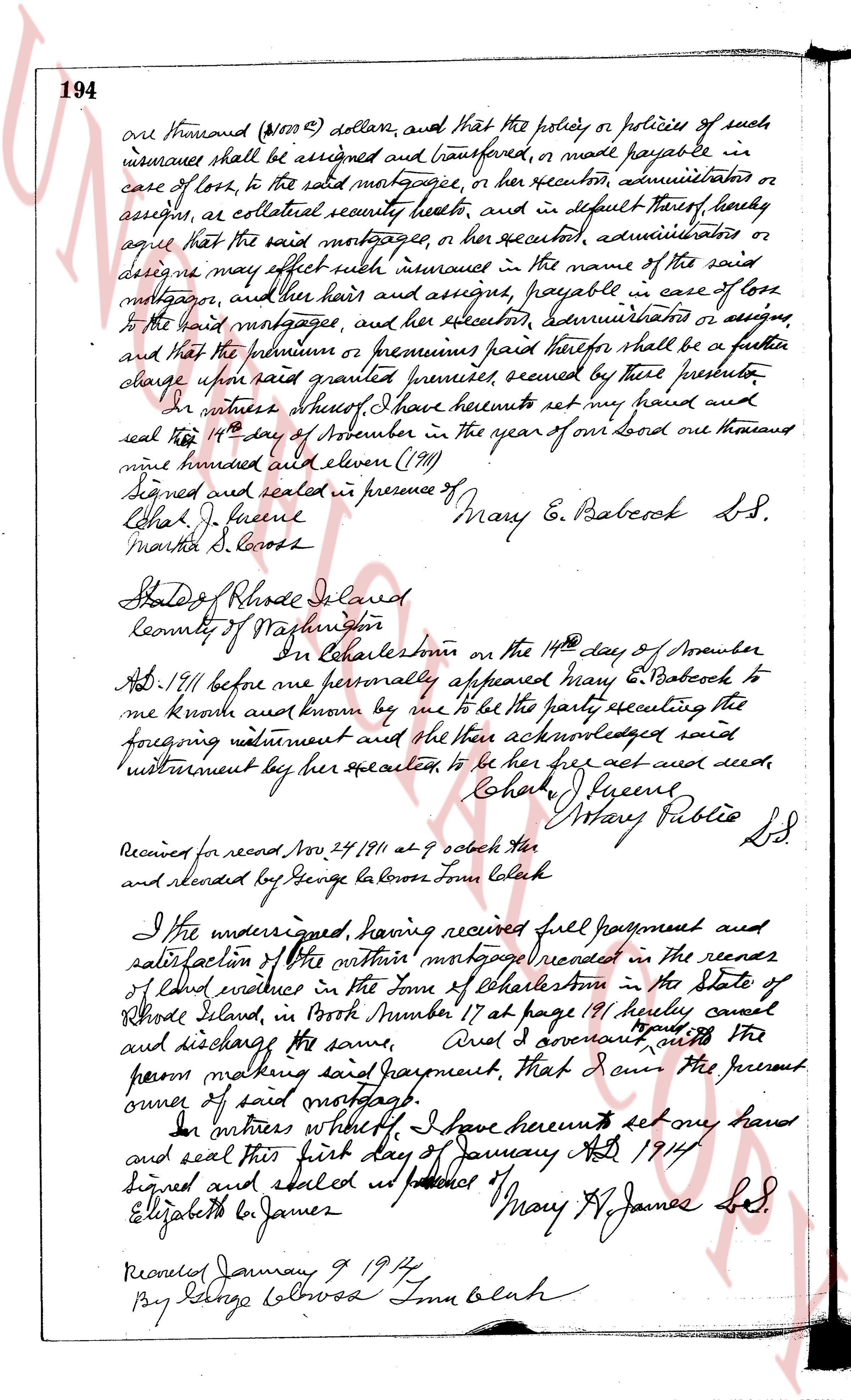
The instrument's own words
Attribution under review. The portal's file number is shared by more than one instrument, and the words below could not be placed with certainty on this one by their own evidence (page stamp, parties, dates); they may belong to a neighbouring instrument. Read them as the record of the page, not yet as this deed's own.
page 1
875
KNOW ALL MEN BY THESE PRESENTS, That We, WE. HOMERE J. JALBERT AND MARY A. JALBERT, husband and wife, of
Charlestown, Rhode Island, hereinafter called the "mortgagors", in consideration of Five Thousand Three Hundred
& 00/100 ($5,300.00) Dollars, to be paid by INDUSTRIAL NATIONAL BANK OF PROVIDENCE, a national banking association
organized and existing under the laws of the United States of America, with its principal place of business in the
City and County of Providence in the State of Rhode Island, hereinafter called the "mortgagees", the receipt whereof
is hereby acknowledged, do hereby grant to the mortgagees, its successors and assigns forever, WITH MORTGAGE COVENANTS,
to secure the payment of the principal and of a certain promissory note of the mortgagees of even date herewith
and bearing the serial number hereof, the following:—
A certain tract of land, with the buildings and improvements thereon, located in the Village of
Carolin, Town of Charlestown, County of Washington and State of Rhode Island, bounded and described
as follows:—
BEGINNING at a large rock on the southerly side of the Charlestown Turn Road, so called, said large
rock be the northeasterly corner of a parcel of land now or formerly held by Ricky Annon and Selma
a Gabriel, being then on the northerly side of the Charlestown Turn Road, thence running south
a distance of 225 feet to the easterly boundary of an area’ house; thence turning and running south east
a distance of 220 feet to a stake; thence turning and running south east to a cedar tree, then a distance
a distance of 125 feet south east turning and running south East 34° a distance of 177 feet thence South
29° a distance of 230 feet to a stake; thence turning and running south east a distance of 125 feet
a distance of 125 feet south east turning and running South East 34° a distance of 177 feet thence South
29° a distance of 230 feet to a stake; thence turning and running south east to a cedar tree, then a distance
are a stone wall & are bounded easterly and northerly under now or formerly held by Sarah Abigail
Nelson or her heirs, thence turning and running north west 20° south east bounding westerly by
land now or formerly held by Sarah Abigail Nelson along the line of a stone wall for a distance
a distance of 1675 feet to a cedar post; thence turning and running north west 20° south east bounding westerly by
land now or formerly held by Sarah Abigail Nelson along the line of a stone wall for a distance of 505 feet to a
bend south east along side of a stone wall to a large fallen white pine tree; thence turning and running south
59° west bounded south east along side of a stone wall to a large fallen white pine tree; thence turning and running south
59° west bounded south east along side of a stone wall to a large fallen white pine tree; thence turning and running south
59° west bounded south east along side of a stone wall to a large fallen white pine tree; thence turning and running south
59° west bounded south east along side of a stone wall to a large fallen white pine tree; thence turning and running south
13° east along stone wall on the south side of said strip a distance of 140 feet to a point on a road; thence running
south 13° east along stone wall on the south side of said strip a distance of 140 feet to a point on a road; thence turning
and running north 20° west South East a distance of 310 feet; thence turning and running North West 30° east a distance
of 210 feet to a pile of stones at a stone boundary; thence turning and running North West 30° east a distance
of 210 feet to a pile of stones at a stone boundary; thence turning and running North West 30° east a distance
of 210 feet to a pile of stones at a stone boundary; thence turning and running North East 18° east a distance
of 230 feet; thence turning and running North East 60° west a distance of 318 feet; thence turning and running North
East 60° west a distance of 318 feet; thence turning and running North East 60° west a distance of 318 feet; thence turning
East a distance of 237 feet; thence turning North East 13° east a distance of 200 feet to the center line of opposite liner
distance of 200 feet to the center line of opposite liner distance of 200 feet to the center line of opposite liner
distance of 200 feet to the center line of opposite liner distance of 200 feet to the center line of opposite liner
westerly bounded by land owned by Selma Nelson, until intersecting the Charlestown Turn Road, so called, and
running and North West 20° south east to the point of beginning, and containing 86 acres, more or less, nor
otherwise containing.
The above described premises conveyed to the mortgagors by two deeds, one being from Anna Nelson, individually,
for her undivided one-half interest, dated July 24, 1965 recorded in Book 30, at page 105 of the Charles-
town land evidence records, and the other deed, conveying the other undivided one-half interest, dated August
12, 1965, recorded in Book 30, at page 111 of the Charlestown land evidence records. A similar deed is also made to a part of
said premises, which is recorded in said Land Evidence Records.
The note secured by this mortgage is also secured by a mortgage on real estate in the Town of South
Kingstown, Rhode Island.
This mortgage is made upon the STATUTORY CONDITION and with the STATUTORY POWER OF SALE; provided, however,
that publication of notice of a fore-closure sale may be made alternatively in a public newspaper published in the City
of Providence, and that a foreclosure sale may be held upon the premises or elsewhere at the option of the mortgagees,
as specified in said notice.
This Mortgage is made subject to those additional covenants and agreements contained in a STATEMENT OF COVENANTS
AND AGREEMENTS, a copy thereof having this date been received by the mortgagees, the receipt whereof is hereby acknowledged,
the exact terms of which are entered on said Charlestown Land Evidence Records, in Book 30, at page 60. Said covenants
and agreements are by hereby reference made part of this mortgage, and if default shall be made in the performance or
observance of any of the same, it shall be lawful for the mortgagee to sell the above described premises pursuant to said
STATUTORY POWER OF SALE.
IN WITNESS WHEREOF, the mortgagors have executed these presents on the 14th day of September 1960.
HOMERE J. JALBERT
MARY A. JALBERT
STATE OF RHODE ISLAND
COUNTY OF WASHINGTON
I In Westerly, on the 14th day of September 1960, before me personally appeared the above named HOMERE J. JALBERT
and MARY A. JALBERT, to me known and known by me to be the parties executing the foregoing instrument and acknowledged
said instrument by them to be executed, to be their free act and deed.
HAROLD B. SOLOVEITZEK
Notary Public
Received for record September 15th, A. D. 1960 at 9:25 o'clock, a. m., and recorded by
Town Clerk
(FOR DISCHARGE OF ABOVE MORTGAGE, SEE PAGE 376)
page 2
of Irving Th Avenue, thence Easterly bounding Northerly by land of
said Irving Therefore to a corner near a small pond, thence Southerly
bounding Easterly by land of said Greene to the highway, thence
Westerly on said highway, thence Northerly bounding Easterly partly
on land of George G Johnson and partly on land of Ernest E Heaton,
thence Westerly bounding Southerly by land of Ernest E Heaton near
said housing ground. Reserving however to Henry J Greene his
heirs and assigns the old school house building and the old
shop with about one acre of land marked by bounds, and
also a privilege to take maple salts from the well on said premises
for use on said reserved lot, or however the same may be
convenient, also all live stock now on said premises.
To have and to hold the above described premises, with
all the tenements and appurtenances thereunto belonging, unto
and to the use of the said Granute, and her heirs and
assigns forever. And we the said Grantors, do hereby for
ourselves and our heirs executors and administrators covenant
with the said Granute and her heirs and assigns that we are
lawfully seized in fee simple of the said granted premises,
that the same are free from all incumbrances That we
have good right full power and lawful authority to sell
and convey the same in manner aforesaid That the
said Granute and her heirs and assigns shall by these
presents at all times hereafter peaceably and quietly
have and enjoy the said premises, and that we the
said Grantors will warrant and defend the same
to the said Granute and her heirs and assigns forever
against the lawful claims and demands of all
persons.
In witness whereof we have hereunto set our
hands and seals this 19 day of June in the year of
our Lord one thousand nine hundred and fourteen.
Signed and sealed in presence of
Singe L Comer Otto N Schanzeil S S
Joseph & Donphear Anna E Schanzeil S S
State of Rhode Island
County of Washington
On Charlestons on the 17 day of
June AD 1914 before me personally appeared
Otto N Schanzeil to me known and known by
me to be the Party sealing the foregoing
page 3
134
instrument and he acknowledged said instrument being
executed, to be his free act and deed.
George own Lowe
Notary Public.
State of Rhode Island
County of Washington
In Richmond on the 19th day of June AD 1914
before me personally appeared Winnie E Schannell to me
known and known by me to be the party executing the
foregoing instrument and she acknowledged said
instrument by her executed to be her free act and deed.
Joseph Co Danphian
Notary Public SS
Received for record Nov 5 1914 at 9 oclock AM.
and recorded by George own Lowe town Clerk
KNOW ALL MEN by these presents that I
Hazard R Burdick of Charlestown in the County of
Washington and State of Rhode Island in consideration
of the sum of one dollar and other valuable considerations
to me paid by Byron R Bayer of the City and County
of Providence State aforesaid the receipt whereof is
hereby acknowledged do hereby remise, release and
forever quitclaim into the hands of the said Byron R Bayer
his heirs and assigns forever all the right title
interest property claim and demand which I may
have or of right ought to have, of claim or in and to
a certain tract of land situated in said Charlestown
being Lot No 45 on "Plat of Cottage Sites on property
of N M Burdick intersecting East Beach road Charlestown
RI" by Gott Woodward' which said plat is on record
in Land Evidence of said Charlestown Book 117 page
46 reference there being made for a more particular
description To have and to hold the
same with all the rights privileges and appurtenances
thereto appertaining grants and to the use of the
said Byron R Bayer his heirs and assigns
forever And I the aforementioned Hazard
The page as recorded