The instrument's own words
page 1 · read by Gemma vision
339
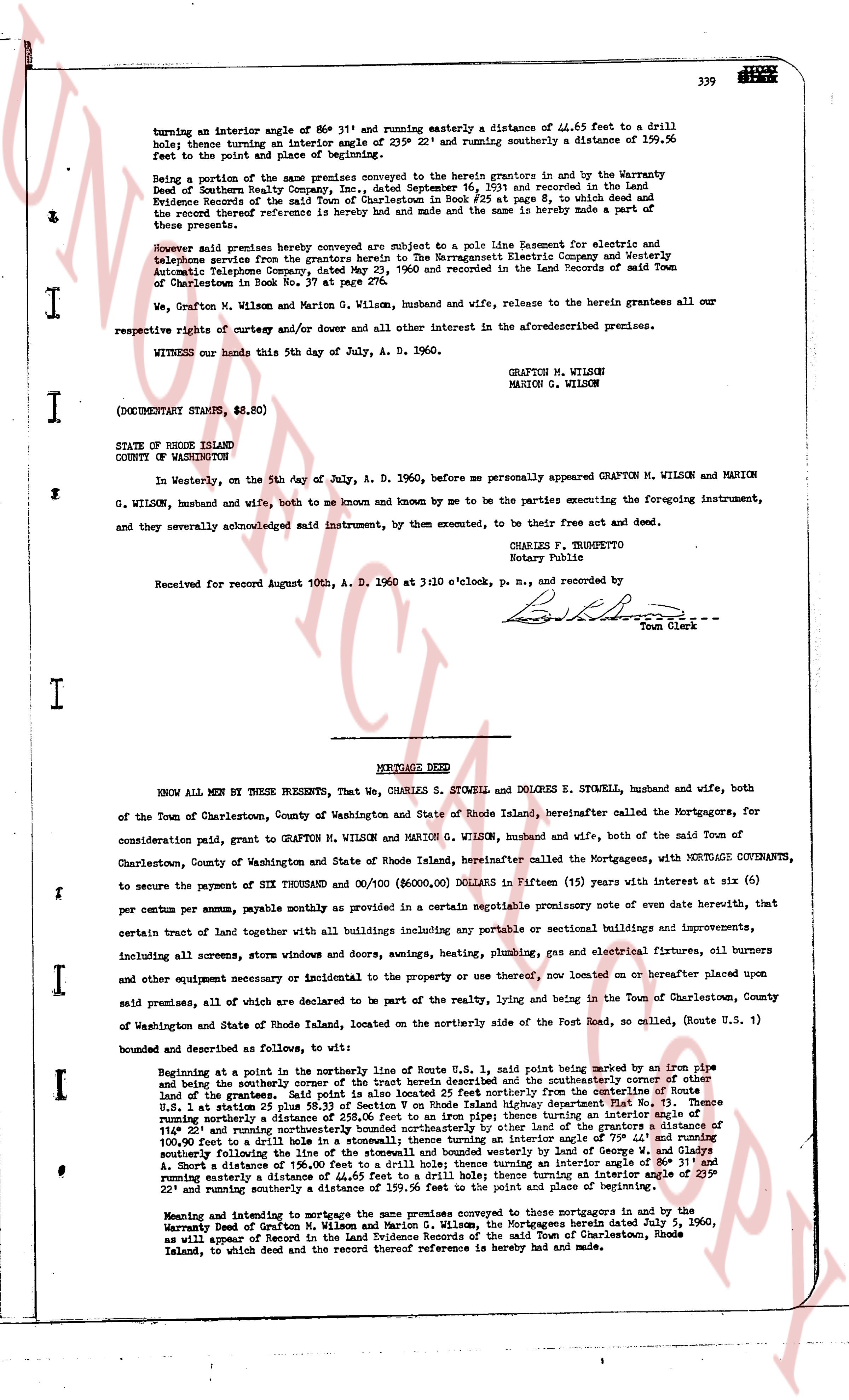
turning an interior angle of 86° 31' and running easterly a distance of 44.65 feet to a drill hole; thence turning an interior angle of 239° 22' and running southerly a distance of 159.56 feet to the point of the point and place of beginning.
Being a portion of the same premises conveyed to the herein grantors in and by the Warranty Deed of Southern Realty Company Inc., dated September 16, 1951 and recorded in the land Evidence Record of the said town at book 28, page 233 of which deed and the record thereof reference is hereby made and made and the same is hereby made a part of these present.
Moreover said premises described are subject to a pole line Right of way easement for and telephone sprites grants from the grantors herein to The Narragansett Electric Company and Western Automatic Telephone Company, dated June 23, 1960 and recorded in the Land Records of said Town of Charlestown book Vol. No. 37 at page 333.
We, Grafton M. Wilson and Marion G. Wilson, husband and wife, release to the herein grantees all our respective rights of entry and/or dower and all other interest in the aforementioned premises.
WITNESS our hands this 5th day of July, A. D. 1960.
GRAFTON M. WILSON
MARION G. WILSON
(DOCUMENTARY STAMPS, $8.80)
STATE OF RHODE ISLAND
COUNTY OF WASHINGTON
In Westerly, on the 5th day of July, A. D. 1960, before me personally appeared GRAFTON M. WILSON and MARION G. WILSON, husband and wife, both to me so known and known by me to be the parties executing the foregoing instrument, and they severally acknowledged said instrument, by them executed, to be their free act and deed.
CHARLES F. TRUSPETTO
Notary Public
Received for record August 10th, A. D. 1960 at 3:10 o'clock, p. m., and recorded by
[Signature]
Town Clerk
----
MORTGAGE DEED
KNOW ALL MEN BY THESE PRESENTS, That We, CHARLES S. STOWELL and DOLORES E. STOWELL, husband and wife, both of the Town of Charlestown, County of Washington and State of Rhode Island, hereinafter called the Mortgagors, for consideration paid, grant to GRAFTON M. WILSON and MARION G. WILSON, husband and wife, both of the said Town of Charlestown, County of Washington and State of Rhode Island, hereinafter called the Mortgagees, with MORTGAGE COVENANTS, to secure the payment of SIX THOUSAND and 00/100 ($6,000.00) Dollars in Fifteen (15) years with interest at six (6) per centum per annum, payable monthly pursuant to a certain negotiable promissory note of even date herewith, that certain tract of land together with all buildings including any optional or sectional buildings and improvements, including all screens, storm windows and doors, heating, heating, plumbing, gas and electrical fixtures, oil burners and other necessary equipment or incidental to the property or used on or hereafter placed upon said premises, all of which are declared to be part of the realty, lying and being in the Town of Charlestown, County of Washington and State of Rhode Island, located on the northerly side of the Route Post road, so called, (Route U.S. 1) bounded and described as follows, to wit:
Beginning at a point in the northerly line of Route U.S. 1, said point being marked by an iron pipe and being the westerly corner of the tract herein described and the southeasterly corner of other land of the grantees, said point being further identified by its distance from the southeasterly corner of other land of the grantees, said point lying on the center line of Rhode Island highway department Plat No. 3, Thence U. S. 1 at rate 28° 15' and running northerly a distance of 117.00 feet; thence turning an interior angle of 117° 20' and running northerly a distance of 258.20 feet to an iron pipe; thence turning an interior angle of 100.00 feet to a drill hole in a stonewall; thence turning an interior angle upon 79° 44' and running southeasterly following the line of a stonewall a distance of 117.00 feet to a load of Sewage Treatment Plant A. Short a distance of 156.00 feet to a drill hole; thence turning an interior angle of 86° 31' and running easterly a distance of 44.65 feet to a drill hole; thence turning an interior angle of 239° 22' and running southerly a distance of 159.56 feet to the point and place of beginning.
Meaning and intending to mortgage the same premises conveyed to these mortgagees in and by the Warranty Deed of Grafton M. Wilson and Marion G. Wilson, dated July 1, 1960, and recorded in the Land Evidence Record of the said Town of Charlestown, Rhode Island, to which deed and the record thereof reference is hereby made and made.
page 2 · read by Gemma vision
340
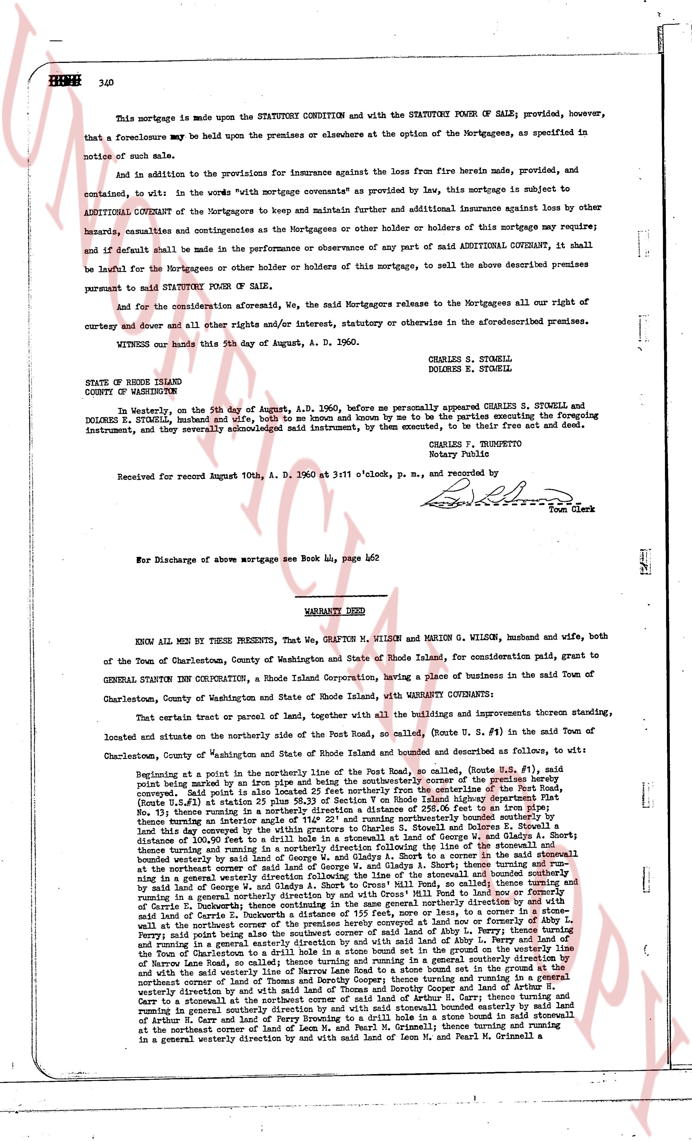
This mortgage is made upon the STATUTORY CONDITION with and the STATUTORY POWER OF SALE; provided, however, that a foreclosure may be held upon the premises or elsewhere at the option of the Mortgagees, as specified in notice of such sale.
And in addition to the provisions for insurance against the loss from fire herein made, provided, and contained, to wit: in the words "with mortgage covenants" as provided by law, this mortgage is subject to ADDITIONAL COVENANT of the Mortgagors to keep and maintain further and additional insurance against loss by other hazards, calamities and contingencies as the Mortgagees or other holder of holdens of this mortgage may require; and if default shall be made in the performance or observance of any part of said ADDITIONAL COVENANT, it shall be lawful for the Mortgagees or other holder or holdens of this mortgage, to sell the above described premises pursuant to said STATUTORY POWER OF SALE.
And for the consideration aforesaid, We, the said Mortgagors release to the Mortgagees all our right of curtesy and dower and all other rights and/or interest, statutory or otherwise in the aforementioned premises.
WITNESS our hands this 5th day of August, A. D. 1960.
CHARLES S. STOWELL
DOLORES E. STOWELL
STATE OF RHODE ISLAND
COUNTY OF WASHINGTON
In Westerly, on the 5th day of August, A.D. 1960, before me personally appeared CHARLES S. STOWELL and DOLORES E. STOWELL, husband and wife, both to me known and known by me to be the parties executing the foregoing instrument, and severally acknowledged said instrument, by them executed, to be their free act and deed.
CHARLES F. TRUMPETTO
Notary Public
Received for record August 10th, A. D. 1960 at 3:11 o'clock, p. m., and recorded by [Signature] Town Clerk
----
War Discharge of above mortgage see Book 44, page 462
----
WARRANTY DEED
KNOW ALL MEN BY THESE PRESENTS, That We, GRAFTON M. WILSON and MARION G. WILSON, husband and wife, both of the Town of Charlestown, County of Washington and State of Rhode Island, for consideration paid, grant to GENERAL STATIONS INC Corporation, a Rhode Island Corporation, having a place of business in the said Town of Charlestown, County of Washington and State of Rhode Island, with WARRANTY COVENANTS:
That certain tract or parcel of land, together with all the buildings and improvements thereon standing, located and situate on the northerly side of the Post Road, so called, (Route U. S. #1) in the said Town of Charlestown, County of Washington and State of Rhode Island and bounded and described as follows, to wit:
Beginning at a point in the northerly line of the Post Road, so called, (Route U. S. #1), said point being marked by an iron pipe and in the line joining the center of the county of Rhode Island, said point being also in the line joining the center of the northerly line from the centerline of the Post Road, (Route U. S. #1) at station 25 plus 58.33 feet of Section 10 on Rhode Island Route #1, said point being also in the line joining the center of the northerly line of the land of the heirs of the late John and Mary Moore, in the Town of Charlestown, to an iron pipe, No. 11, then running in a generally easterly direction to a point in the line of the land of Charles S. Stowell and Dolores E. Stowell, thence turning an angle interior OS 116° 24' and running northerly to an iron pipe, said land lay described by a deed from George and Mary Moore to Charles S. Stowell and Dolores E. Stowell, distance of 100.90 feet to a drill hole in a stone wall in Glandoy at land of George W. and Gladys A. Short; thence turning an angle interior OS 118° 24' and running in a generally easterly direction to a stone wall in stone wall boundary wedged by land of George W. and Gladys A. Short to a corner in the said stonewall at the northeaster corner of said land of George W. and Gladys A. Short; thence turning an angle interior OS 118° 24' and running in a general westerly direction following the line of the stonewall and boundary northerly said land of George W. and Gladys A. Short to a point in said stone wall and boundary northerly said land of George W. and Gladys A. Short to a point in said stone wall and boundary northerly said land of Carrie E. Dunbrack, distance of 155 feet, more or less, to a corner in a stone wall in the land of Carrie E. Dunbrack; thence turning an angle interior OS 140° 20' and running in a generally easterly direction to a point in said land of Carrie E. Dunbrack a distance of 155 feet, more or less, to a corner in a stone wall in the land of Carrie E. Dunbrack; thence turning an angle interior OS 140° 20' and running in a general westerly direction to a point in said land of Carrie E. Dunbrack; thence turning an angle interior OS 140° 20' and running in a general westerly direction on and with Cross Mill Pond to land now or formerly of Carrie E. Dunbrack, then running in a generally southerly direction to a point in the line of the land of Carrie E. Dunbrack; thence turning an angle interior OS 140° 20' and running in a general westerly direction to a point in said land of Carrie E. Dunbrack; thence turning an angle interior OS 140° 20' and running in a general westerly direction to a point in said land of Carrie E. Dunbrack; thence turning an angle interior OS 140° 20' and running in a general westerly direction to a point in said land of Carrie E. Dunbrack; thence turning an angle interior OS 140° 20' and running in a general westerly direction to a point in said land of Carrie E. Dunbrack; thence turning an angle interior OS 140° 20' and running in a general westerly direction to a point in said land of Carrie E. Dunbrack; thence turning an angle interior OS 140° 20' and running in a general westerly direction to a point in said land of Carrie E. Dunbrack; thence turning an angle interior OS 140° 20' and running in a general westerly direction to a point in said land of Carrie E. Dunbrack; thence turning an angle interior OS 140° 20' and running in a general westerly direction to a point in said land of Carrie E. Dunbrack; thence turning an angle interior OS 140° 20' and running in a general westerly direction to a point in said land of Carrie E. Dunbrack; thence turning an angle interior OS 140° 20' and running in a general westerly direction to a point in said land of Carrie E. Dunbrack; thence turning an angle interior OS 140° 20' and running in a general westerly direction to a point in said land of Carrie E. Dunbrack; thence turning an angle interior OS 140° 20' and running in a general westerly direction to a point in said land of Carrie E. Dunbrack; thence turning an angle interior OS 140° 20' and running in a general westerly direction to a point in said land of Carrie E. Dunbrack; thence turning an angle interior OS 140° 20' and running in a general westerly direction to a point in said land of Carrie E. Dunbrack; thence turning an angle interior OS 140° 20' and running in a general westerly direction to a point in said land of Carrie E. Dunbrack; thence turning an angle interior OS 140° 20' and running in a general westerly direction to a point in said land of Carrie E. Dunbrack; thence turning an angle interior OS 140° 20' and running in a general westerly direction to a point in said land of Carrie E. Dunbrack; thence turning an angle interior OS 140° 20' and running in a general westerly direction to a point in said land of Carrie E. Dunbrack; thence turning an angle interior OS 140° 20' and running in a general westerly direction to a point in said land of Carrie E. Dunbrack; thence turning an angle interior OS 140° 20' and running in a general westerly direction to a point in said land of Carrie E. Dunbrack; thence turning an angle interior OS 140° 20' and running in a general westerly direction to a point in said land of Carrie E. Dunbrack; thence turning an angle interior OS 140° 20' and running in a general westerly direction to a point in said land of Carrie E. Dunbrack; thence turning an angle interior OS 140° 20' and running in a general westerly direction to a point in said land of Carrie E. Dunbrack; thence turning an angle interior OS 140° 20' and running in a general westerly direction to a point in said land of Carrie E. Dunbrack; thence turning an angle interior OS 140° 20' and running in a general westerly direction to a point in said land of Carrie E. Dunbrack; thence turning an angle interior OS 140° 20' and running in a general westerly direction to a point in said land of Carrie E. Dunbrack; thence turning an angle interior OS 140° 20' and running in a general westerly direction to a point in said land of Carrie E. Dunbrack; thence turning an angle interior OS 140° 20' and running in a general westerly direction to a point in said land of Carrie E. Dunbrack; thence turning an angle interior OS 140° 20' and running in a general westerly direction to a point in said land of Carrie E. Dunbrack; thence turning an angle interior OS 140° 20' and running in a general westerly direction to a point in said land of Carrie E. Dunbrack; thence turning an angle interior OS 140° 20' and running in a general westerly direction to a point in said land of Carrie E. Dunbrack; thence turning an angle interior OS 140° 20' and running in a general westerly direction to a point in said land of Carrie E. Dunbrack; thence turning an angle interior OS 140° 20' and running in a general westerly direction to a point in said land of Carrie E. Dunbrack; thence turning an angle interior OS 140° 20' and running in a general westerly direction to a point in said land of Carrie E. Dunbrack; thence turning an angle interior OS 140° 20' and running in a general westerly direction to a point in said land of Carrie E. Dunbrack; thence turning an angle interior OS 140° 20' and running in a general westerly direction to a point in said land of Carrie E. Dunbrack; thence turning an angle interior OS 140° 20' and running in a general westerly direction to a point in said land of Carrie E. Dunbrack; thence turning an angle interior OS 140° 20' and running in a general westerly direction to a point in said land of Carrie E. Dunbrack; thence turning an angle interior OS 140° 20' and running in a general westerly direction to a point in said land of Carrie E. Dunbrack; thence turning an angle interior OS 140° 20' and running in a general westerly direction to a point in said land of Carrie E. Dunbrack; thence turning an angle interior OS 140° 20' and running in a general westerly direction to a point in said land of Carrie E. Dunbrack; thence turning an angle interior OS 140° 20' and running in a general westerly direction to a point in said land of Carrie E. Dunbrack; thence turning an angle interior OS 140° 20' and running in a general westerly direction to a point in said land of Carrie E. Dunbrack; thence turning an angle interior OS 140° 20' and running in a general westerly direction to a point in said land of Carrie E. Dunbrack; thence turning an angle interior OS 140° 20' and running in a general westerly direction to a point in said land of Carrie E. Dunbrack; thence turning an angle interior OS 140° 20' and running in a general westerly direction to a point in said land of Carrie E. Dunbrack; thence turning an angle interior OS 140° 20' and running in a general westerly direction to a point in said land of Carrie E. Dunbrack; thence turning an angle interior OS 140° 20' and running in a general westerly direction to a point in said land of Carrie E. Dunbrack; thence turning an angle interior OS 140° 20' and running in a general westerly direction to a point in said land of Carrie E. Dunbrack; thence turning an angle interior OS 140° 20' and running in a general westerly direction to a point in said land of Carrie E. Dunbrack; thence turning an angle interior OS 140° 20' and running in a general westerly direction to
The page as recorded