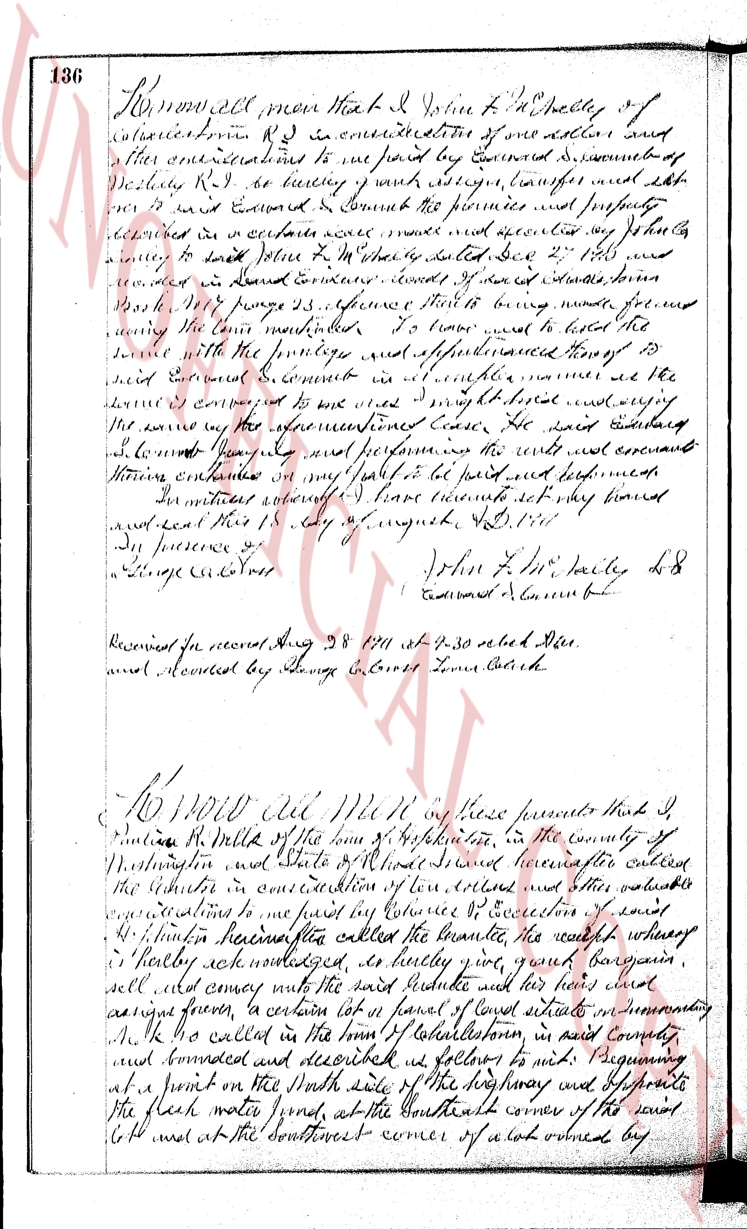
The instrument's own words
Attribution under review. The portal's file number is shared by more than one instrument, and the words below could not be placed with certainty on this one by their own evidence (page stamp, parties, dates); they may belong to a neighbouring instrument. Read them as the record of the page, not yet as this deed's own.
page 1
829
PARTIAL RELEASE OF MORTGAGE
Industrial National Bank of Providence, a national banking association organized and existing under the laws
of the United States of America and having its principal office in the City and County of Providence and State of
Rhode Island, the holder of a (real estate) (mortgage) mortgage by PHILIP E. STARRETT and AMI W. STARRETT to INDUSTRIAL
NATIONAL BANK OF PROVIDENCE dated December 17, 1958 and recorded in the Records of Land Evidence in the Town of Charles-
ton in Book No. 36 at Page 485, considers for paid consideration, releases to PHILIP E. STARRETT and AMI W. STARRETT, all
interest acquired under said mortgage in the following described portion of the mortgaged property:
That certain parcel of land with all improvements thereon situated, on the northerly shore of
Charles-ton Pond, so-called, in the Town of Charlestown and State of Rhode Island, bounded and described as follows:
bounded in the easterly in the same line of land now or lately of Robert M. Hills, Jr., et al., such point being marked by a
stone bound and then running northwesterly along the line of said Robert M. Hills, Jr., and being the north-
easterly corner of said Mills land; thence running southwesterly and along the boundary line of said land of Robert
M. Hills, Jr. to the place of their tract described herein and proceeding 126 1/2 feet southerly from the northeasterly
corner of said Mills land; thence running southwesterly to a stone bound thence turning an interior angle of 90° and running
southwesterly to a stone bound; thence running southwesterly 125 1/2 feet to a stone bound; thence running south-
westerly, bounding easterly by other land of this Grantor; thence running southeasterly a distance of 25 feet, more or less, to
the shore of Charlestown Pond; thence following the shore line of said Charlestown Pond southerly and westerly a distance
of 100 feet, bounding easterly by the shore of Charlestown Pond; thence following the shore line of said Charlestown Pond
southerly and westerly a distance of 25 feet, more or less, to a stone bound; thence running northwesterly to the northeasterly corner of said Mills land;
thence running northerly, bounding westerly by said Mills land, a distance of 40 feet, more or less, to a stone bound;
thence running northwesterly to a stone bound; thence running northwesterly to the bounding easterly by other land of said
Mills land, 136.29 feet to the place of beginning, the last course making an interior angle of 90° with the first course,
containing 0.90 acres more or less, together with the right of serve by access through 10 feet of area by suitable path.
TOGETHER with all rights of way as being granted by these grantees to William H. Fornal et ux.
Reserving, however, to said Industrial National Bank of Providence all of its right, title and interest under said
mortgage in and to all other property described therein.
In WITNESS WHEREOF Industrial National Bank of Providence has caused the presents to be signed and its corporate
seal to be hereto affixed by its proper officers or representatives thereto duly authorized this 22nd day of July, 1960.
A. D. 1960.
INDUSTRIAL NATIONAL BANK OF PROVIDENCE (Corporate Seal)
By Hiram Kendall
Assistant Vice President
By Fred Rainer
Assistant Manager
STATE OF RHODE ISLAND
COUNTY OF WASHINGTON
On Wednesday on the 22nd day of July, A. D. 1960, before me personally appeared HIRAM KENDALL and FRED RAINER,
to me known to be the persons known to be as Assistant Vice-President and Assistant Manager respectively and of the persons
executing the foregoing instrument on behalf of Industrial National Bank of Providence, and they acknowledged said
instrument, by them so executed a voluntary act and deed in themselves and of the free act and deed
of Industrial National Bank of Providence.
HEROLD B. SOLOVEITZEV
Notary Public
Received for record August 2nd, A. D. 1960 at 2:59 o'clock, p. m., and recorded by
[Signature]
Town Clerk
WARRANTY DEED
We, PHILIP E. STARRETT and AMI W. STARRETT, his wife, both of the Town of Charlestown and State of Rhode Island,
for consideration paid, grant to WILLIAM H. FORNAL and OLIVE B. FORNAL, his wife, both of Manchester in the State of
Connecticut, as joint tenants and not as tenants in common, with WARRANTY CONVEYANCE,
That certain parcel of land with all improvements thereon situated on the northerly shore of Charles-
ton Pond, so-called, in the Town of Charlestown and State of Rhode Island, bounded and described as
follows:
Beginning in the easterly line of land now or lately of Robert M. Hills, Jr., et al., such point
being marked by a stone bound and being the northeasterly corner of the tract herein described and
clocked Three Hundred Twenty-Five (325) feet, thence running northwesterly along the line of said Robert M. Hills, Jr.,
and being the northeasterly corner of said Mills land; thence running easterly, bounding northerly on other land of these Grantors, Two Hundred
Fifty-three and 27/100 (253.27) feet to a stone bound; thence turning an interior angle of 90° and running
southerly to a stone bound; thence running southerly to a stone bound; thence running Southeasterly Seven Hundred
and 18/100 (700.18) feet to a stone bound; thence turning an interior angle of 205° and running
southwesterly a distance of 100 feet, bounding easterly by the shore of Charlestown Pond; thence following the
shore line following the shore line of said Charlestown Pond southerly and westerly a distance of
Five Hundred Thirty (530) feet to the northeasterly corner of said Mills land; thence running northwesterly to a stone
thence running northerly, bounding westerly by said Mills land, a distance of Forty (40) feet, more
or less, to a stone bound; thence continuing northerly in the same straight line, bounding westerly
page 2
330
by said Mills land, One Thousand Three Hundred Thirty-six and 29/100 (1336.29) feet to the
place of beginning, the last course making an interior angle of 90° with the first described
course. Said parcel contains an area of Right (8) acres by estimation.
Together with a right of way in common with others and appurtenant to the parcel herein conveyed,
from the said First Parcel, described above, to the land of Barrett by John R. Higgins by instru-
ment dated May 24, 1960, and recorded in the Land Evidence records of Town of Charlestown in
Book 28 on pages 21 and 214.
Also a right of way in common with others and appurtenant to the parcel herein conveyed, to pass
and egress on and over a strip of land with vents and exits or a strip of land Twenty (20) feet in width
and running along the northerly boundary of said parcel, either in fee or lease of term of years or
easement, from said Right way in the meaning the high water mark of Potter Cove, easterly the line
of said right of way being in the meaning the high water mark of said Cove and westerly the inner
line of said right of way being parallel to and twenty (20) feet from the easterly line of the parcel herein
conveyed.
Said premises are conveyed subject to any easements which Margarettset Electric Company may have
to construct, reconstruct, repair, maintain and operate facilities for the transmission of elec-
tricity current for the benefit of the public, over and across said Company or acquired by it.
Said premises are conveyed subject to the following restrictive conditions:
1. Said premises shall be used only for residential purposes, and no buildings or other
structures shall be erected, altered, placed or permitted to remain thereon other
than a detached single-family dwelling house and a detached private garage (if any)
not more than two (2) cars. A basement shall not be used for dwelling. Neither the
dwelling house nor the garage shall be used for other structures, shall at any time
hereafter be used for manufacturing, industrial, mercantile, or any commercial
purpose.
2. Not more than one dwelling house shall be built on any land area of less than 10,000 square
feet provided however, that in the event the land covered by this agreement is platte
for such restrictions, the Grantors shall provide the instrument conveying the home
party on one lot and on an adjoining lot, these joined lots to be treated as one
one lot in the plat. Said dwelling to cover an area of not less than five hundred (500)
square feet, this is exclusive of porches, garages, etc.
3. No building shall be located on any lot narrower than seven (7) feet, wherever that it be a side
street or rear street, thirty-two (32) feet, nor nearer twenty-four (24) feet from any side
or rear property line, thirty-two (32) feet from any planes or any other projections of any build-
ing.
4. (a) Foundations constructed of wood must be painted, stained, or stuccoed. In where
in no instance will asphalt paint, tar, or any other initiation materials be used
for exterior walls on buildings.
(b) All constructions of cedar or block construction shall therefore have the exterior
walls covered and completely finished.
(c) All buildings with pitched roofs shall be covered with other than rolled or sheet
roofing.
5. No tanks or automobile repair equipment shall be utilized or permitted on said premises,
and furthermore no lot shall be used or maintained as a dumping ground or storage ground
for any rubbish, trash, garbage, scrap metal or scrap lumber. And the Grantors, their
heirs or assignees, shall have the right if they shall see fit, to cut and mow any weeds
and grasses on the land of the Grantee, and the Grantee improves maid property as
set forth in the restrictions herein under.
6. No livestock or poultry of any kind other than a dog or cat or unusual household pet shall be
kept or permitted to be kept or maintained on said premises.
7. Fences and hedges shall be permitted but no not exceed the height of six (6) feet.
8. All sewage from buildings or enclosures on the premises shall be treated and disposed of by
the owner or occupants of the premises by installing and operating a septic tank or other
with related facilities, and such system shall be constructed and maintained in good sanitary
condition; and further, should any such system not function properly so as to cause any over-
flow or discharge, either onto the surface of the land, into Common areas, into Common
other natural streams or body of water, such occurrence shall be deemed a breach of this covenant,
and the party, or parties concerned shall be immediately subject to the full process of the law.
All toilets must be sanitary finish toilets.
9. In case of a contamination sale of any of the land referred to in this deed, first refusal shall
be given to the Grantors personally, and not to their heirs and assigns, at least ten days
prior to any sale.
10. Invalidity of any one of these covenants and/or restrictions by judgment of a court of law
shall in no wise affect any of the other provisions which shall remain in full force and effect.
11. The aforegoing restrictions are imposed for the benefit of the Grantors, their heirs
and assigns, and of other owners of parcels of lots heretofore or hereafter conveyed by
the Grantors, their heirs or assigns, and any of them enforce the same by resort to
legal process if such action is warranted.
12. The aforegoing restrictions shall be deemed and considered covenants running with the land
and said premises and shall be binding upon the Grantees, and their heirs, executors, adminis-
trators, successors and assigns.
WITNESS our hands this 28th day of July, 1960.
PHILIP E. STARRETT
Philip E. Starrett
AMY W. STARRETT
Amy W. Starrett
page 3
331
STATE OF RHODE ISLAND
COUNTY OF WASHINGTON
In Westerly, on the 28th day of July, 1960, before me personally appeared Philip E. Starrett and Amy W. Starrett,
to me known and known by me to be the parties executing the foregoing instrument, and they acknowledged said instrument,
by them executed, to be their free act and deed.
(DOCUMENTARY STAMPS, $6.60)
HAROLD B. SOLVEIRITZIK
Notary Public
Received for record August 2nd, A. D. 1960 at 3:00 o'clock, p. m., and recorded by
[Signature]
Town Clerk
KNOW ALL MEN BY THESE PRESENTS, that I, HARRIET B. MEYER of 884 Warren Avenue, Thornwood, New York for consid-
eration paid, grant to REV. MAURICE D'ANGELO of 47 Clark Street, New Britain, Connecticut, with QUIT-CLAIM COVENANTS
(Description, and Incumbrances, if any)
That certain real estate situate in Charlestown, County of Washington in the State of Rhode Island,
and described as follows:
Lot No. 17 in the plat of Hazard H. Burdick - East Beach Quonochontaug, surveyed by George W. Woodard
and recorded in the Office of the Town Clerk of Charlestown, Rhode Island.
It is understood that there will be no detached building placed upon this lot.
Being the same premises conveyed to Hazard H. Burdick by deed dated November 22, 1950 and recorded in Book 24,
Page 248 of Deeds of Records, Town of Charlestown, in Charlestown in the State of Rhode Island on November 25,
1950.
I, LARS P. MEYER husband of the grantor HARRIET B. MEYER, release to maid grantee all my right of curtesy and all
other interest in the aforesaid premises.
WITNESS our hands this 15 day of July 1960.
LARS P. MEYER
HARRIET B. MEYER
STATE of NEW Y ORK, ETC., )
County of Westchester ) ss:
In Plansterville on the 15 day of July, 1960 before me personally appeared LARS P. MEYER and HARRIET B. MEYER,
husband and wife to me known and known by me to be the parties executing the foregoing instrument, and they acknowledged
said instrument, by them executed, to be their free act and deed.
ROBERT F. BRISSON (Notarial Seal)
Robert F. Brisson
Notary Public State of New York
No. 60-2455750
Qualified in Westchester County
Term Expires November 20, 1962
STATE OF NEW YORK )
COUNTY OF WESTCHESTER ) ss:
No. 4938
I, EDMUND L. WARREN, Clerk of the County of Westchester and Clerk of the Supreme Court and County Court in
said County, the same being court of record having a seal, DO HEREBY CERTIFY that Robert F. Brisson, whose name is
subscribed to the above certification, is a Notary Public in and for the annexed instrument, was at the time of the
taking a notary Public in and for the State of New York, duly commissioned and sworn and qualified as
such in Westchester County, competent to take acknowledgments of any person or persons before him, or
taking the same a notary Public in and for the State of New York, duly commissioned and sworn and qualified as
such in Westchester County, competent to take acknowledgments of any person or persons before him, or
character, and an autograph signature of said notary Public, have been filed in my office; that said PUBLIC was
duly admitted by the law and custom of said State to practice and admit acknowledgments, and that his signature
or proof of deeds than of either instruments for lands, tenements and hereditaments to be entered or recorded
in said State, to protect the rights of purchasers or others dealing with the owners of such lands, tenements or
in said State, to protect the rights of purchasers or others dealing with the owners of such lands, tenements or
of such Public, and I have compared the signature of said Notary Public on the annexed instrument with such Notary
of such Public's autograph signature deposited in my office, and believe that the signature on the annexed instrument is genuine.
No notary seal required by the laws of the State of New York.
IN WITNESS WHEREOF, I have hereunto set my hand and affixed my official seal this 20 day of July 1960.
(L.S.)
EDMUND L. WARREN
County Clerk and Clerk of the Supreme Court and County
Court, Westchester, N. Y.
Received for record August 3rd, A. D. 1960 at 9:10 o'clock, a. m., and recorded by
[Signature]
Town Clerk
The page as recorded