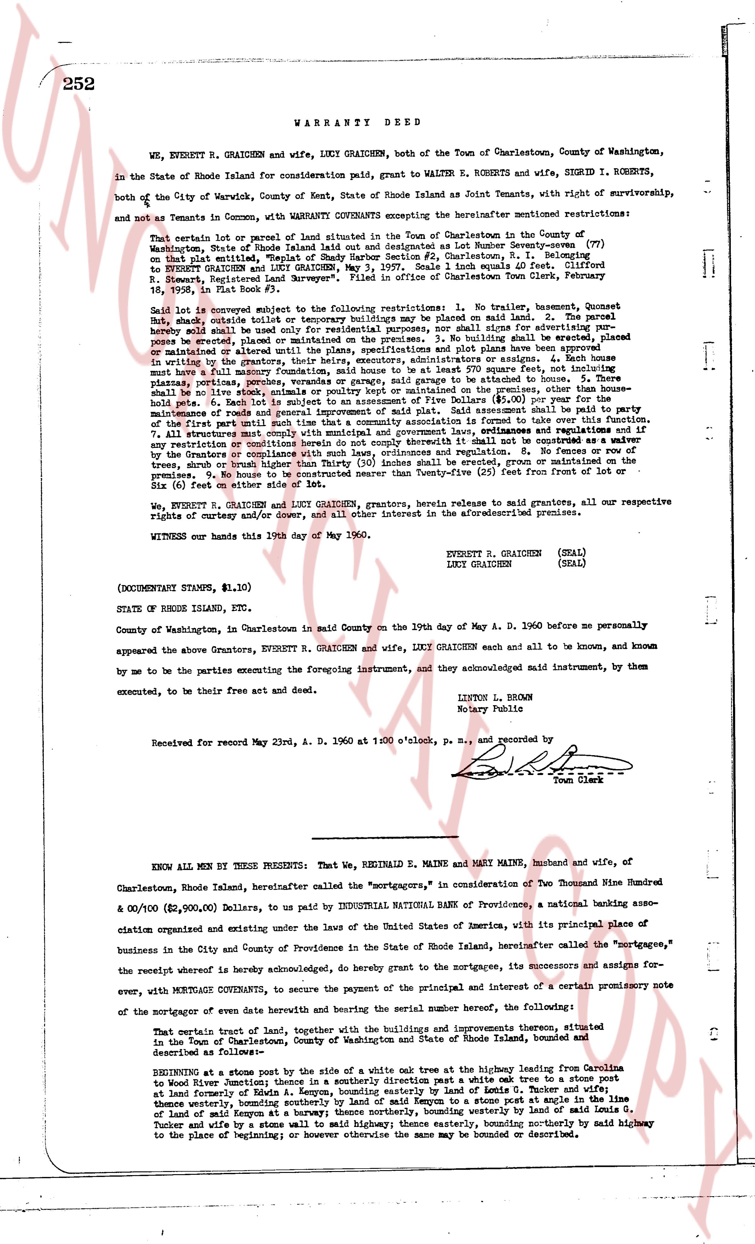
The instrument's own words
page 1 · read by Gemma vision
252 WARRANTY DEED
WE, EVERETT R. GRAICHEN and wife, LUCY GRAICHEN, both of the Town of Charlestown, County of Washington, in the State of Rhode Island for consideration paid, grant to WALTER E. ROBERTS and wife, SIGRID I. ROBERTS, both of the City of Warwick, County of Kent, State of Rhode Island as Joint Tenants, with right of survivorship, and not as Tenants in Common, with WARRANTY COVENANTS encumbering the hereafter mentioned restrictions:
That certain lot or parcel of land situated in the Town of Charlestown in the County of Washington, State of Rhode Island laid out and designated as Lot Number Seventy-seven (77) on said plat including a well, being a part of Lot Number 12, Plat 1, Charlestown, R.I. conveyed to EVERETT R. GRAICHEN and LUCY GRAICHEN, May 3, 1957. Scale 1 inch equals 40 feet. Clifford R. Stewart, Registered Land Surveyor". Filed in office of Charlestown Town Clerk, February 19, 1958, in Book 33, page 111.
Said lot is conveyed subject to the following restrictions: 1. No trailer, houseboat, camper or hut, shack, outside tent or temporary building shall be placed or stationed on said land. 2. The parcel hereby sold shall be used for residential purposes only, nor shall signs advertising for purposes be placed, erected or maintained on the premises. 3. No building shall be built on the land unless plans be placed, erected or maintained on the premises. 3. No building shall be built unless plans and plot have been approved in writing by the grantors, their heirs, executors, administrators or assigns. 4. Each house must have a lot area of not less than 10,000 square feet and not more than 200 square feet, and no garage be attached to the house. 3. There shall be no porches, platfoms, porches, verandas or garage, said garage be attached to the house. 3. There shall be no fences, walls, hedges or screens of any kind, except in the rear yard, where chicken or dog pens shall be held. 6. Each lot is subject to an assessment of Five Dollars ($5.00) per year for the maintenance of roads and other improvements. 7. The grantors reserve the right to amend or change any of the first part until such time that a community association is formed to take over this function. 7. All structures must be built to a standard of construction and appearance. 8. If any of the restrictions or conditions herein do not comply utterly it shall not be construed as a waiver by the Grantors of their right to enforce the same. 9. No fruit, nut, ornamental, shade, evergreen, pine, spruce, tree or shrub higher than Thirty (30) inches shall be erected, grown or maintained from the front of lot or Six (6) feet on either side of lot.
WE, EVERETT R. GRAICHEN and LUCY GRAICHEN, grantors, hereby release to said grantees, all our respective rights of curtesy and/or dower, and all other interest in the aforementioned described premises.
WITNESS our hands this 19th day of May 1960.
EVERETT R. GRAICHEN (SEAL)
LUCY GRAICHEN (SEAL)
(DOCUMENT STAMPS, $1.10)
STATE OF RHODE ISLAND, etc.
County of Washington, in said County on the 19th day of May A. D. 1960 before me personally appeared the above Grantors, EVERETT R. GRAICHEN and wife, LUCY GRAICHEN each and all to be, and known to, and known by me to be the parties executing the foregoing instrument, and they acknowledged said instrument, by them executed, to be their free act and deed.
LYTON L. BROWN
Notary Public
Received for record May 23rd, A. D. 1960 at 1:00 o'clock, p. m., and recorded by
Town Clerk
----
KNOW ALL MEN BY THESE PRESENTS: That, WE REGINALD E. MAINE and MARY MAINE, husband and wife, of Charlestown, Rhode Island, hereinafter called the "mortgagors," in consideration of Two Thousand Nine Hundred & 00/100 ($2,900.00) Dollars, to us paid by INDUSTRIAL NATIONAL BANK of Providence, a national banking association organized and existing under the laws of the United States of America, with its principal place of business in the City and County of Providence in the State of Rhode Island, hereinafter called the "mortgagee," the receipt whereof is hereby acknowledged, do hereby grant to the mortgagee, its successors and assigns for ever, with MORTGAGE COVENANTS, to secure the payment of the principal and interest of a certain promissory note of the mortgagor of even date herewith and bearing the serial number hereof, the following:
That certain tract of land, together with the buildings and improvements thereon, situated in the Town of Charlestown, County of Washington, State of Rhode Island, bounded and described as follows:
BEGINNING at a stone post by the side of a white oak tree at the highway leading from Charlestown to Wood River station; thence in a southerly direction past a white oak tree to a stone post at land formerly of Edwin A. Kenyon, bounding easterly a tract of land in Tenure of Tassey; thence easterly, bounding land of Edwin A. Kenyon, to a stone post at angle in the line of land of said Kenyon at a banyan; thence northerly, winding westerly by land of said Lewis G. Tassey and wife, by a stone wall to a white oak tree, bounding northerly by said highway from the place of beginning; otherwise the same may be bounded or described.
The page as recorded