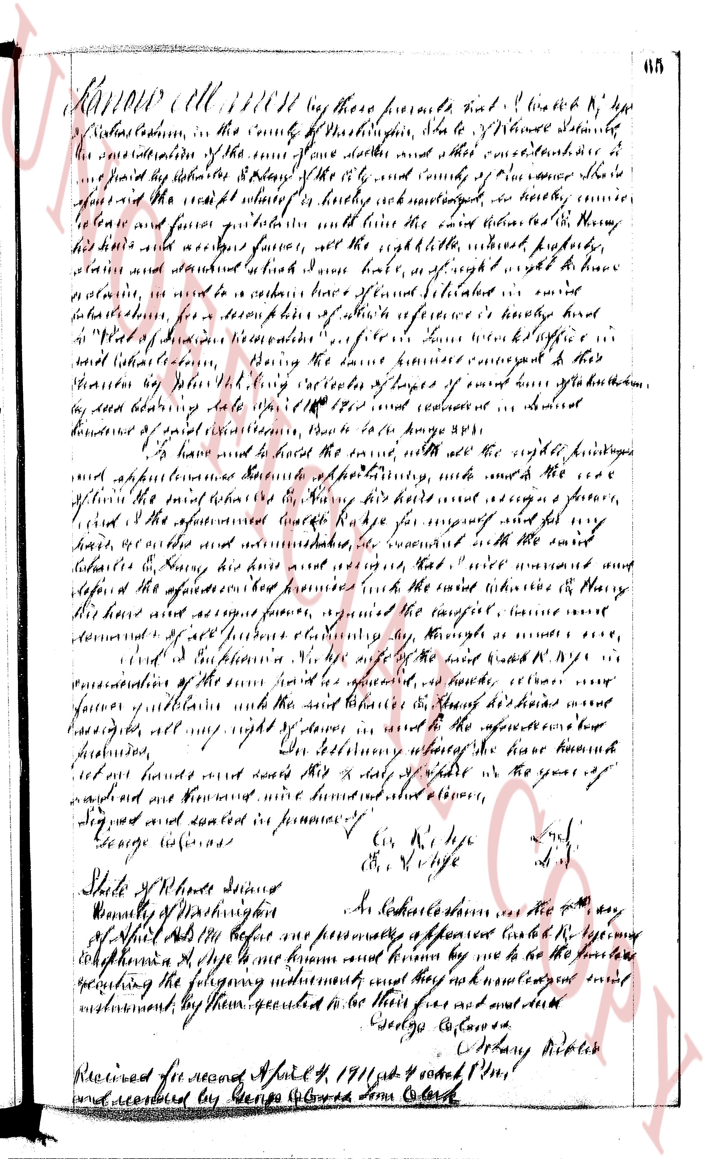
The instrument's own words
Attribution under review. The portal's file number is shared by more than one instrument, and the words below could not be placed with certainty on this one by their own evidence (page stamp, parties, dates); they may belong to a neighbouring instrument. Read them as the record of the page, not yet as this deed's own.
page 1
135
I, Rogers E. Trainer of the Town of Westerly, County of Washington, State of
Rhode Island for consideration paid, grant to Mary Ernestine Buddington of the Town of
Westerly, County of Washington, State of Rhode Island with MORTGAGE COVENANTS, to secure
the payment of Three Thousand (3000) Dollars in five years with interest at six per centum,
per annum, payable semi-annually In advance as provided in a certain negotiable promissory
note of even date herewith.
That certain real estate situated in Charlestown, County of Washington in the
State of Rhode Island, and described as follows:
A certain tract or parcel of land with summer cottage and other improvements
thereon and including the wells, pumps, pipes and furnishings contained therein, said
lot being situated on the southerly side of Surfside Avenue, Quonocutaug
Country Club, Town of Charlestown, Rhode Island, and bounded and described
as follows, to wit:
Lot No 28 as shown and delineated on a certain plan or plat entitled, "Plan
of Quonocutaug Central Beach, Charlestown, Rhode Island, Thorp, Engineer,"
filed August 30 1924 in Book A page 10 by Joseph S. Lewis, engineer, said
plan or plat being on file in the Town Clerk's Office in said Town of Charlestown.
Meaning and intending to convey the same land conveyed to this mortgagor by
Howard S. Thorp by deed dated June 1st 1934 and duly recorded in the
Evidence Records of said Town of Charlestown in Book 21 at page 396.
This deed is subject to all the covenants, conditions, agreements and restrictions
and conveys all the rights, privileges, easements and benefits as expressed in
said deed from Howard S. Thorp to this mortgagor as is recorded reference
to said deed and the records thereof being hereby had and the same are
made a part hereof for more complete description and identification of the
premises hereby conveyed.
This mortgage is made upon the STATUTORY CONDITION and with the STATUTORY POWER
OF SALE.
I, Florence T. Trainer wife of the mortgagor, release to the mortgagee all my
right of dower and all other interest in the aforesaid premises.
WITNESS our hands this 2nd day of July 1935.
ROGERS E. TRAINER (SEAL)
FLORENCE T. TRAINER (SEAL)
STATE OF RHODE ISLAND )
) ss
County of Washington )
In Westerly on the 2nd day of July, 1935 before me personally appeared Rogers
E. Trainer and Florence T. Trainer, husband and wife, to me known and known by me to be the
parties executing the foregoing instrument, and they acknowledged said instrument, by them
executed, to be their free act and deed.
HOWARD S. THORP
Notary Public.
Received for record July 23rd, A. D. 1935 at 9:12 o'clock, a. m., and
recorded by [Signature] Town Clerk.
I the undersigned, having received full payment and satisfaction of the within
mortgage, recorded in the records of land evidence in the Town of Charlestown, the State
of Rhode Island, in Land Evidence Book No. 26 at page 135, hereby cancel and discharge the
same, and I covenant to and with the person making said payment that I am the present owner
of said mortgage. IN WITNESS WHEREOF I have hereunto set my hand and seal this 31st day of
Dec. 1939.
MARY ERNESTINE BUDDINGTON (Seal)
Above discharge received for record January 6th, A. D. 1939 at 9:00 o'clock, a. m., and
recorded by [Signature]
Town Clerk
page 2
244
BEGINNING at an iron pipe set in the ground on the northerly side of the State Highway,
commonly known as the Post Road; said point of beginning being 118.00 feet westerly of
the southeasterly corner of the property of "Philip Hickman" on that certain
plat entitled, "Plan of Property of W. Monroe Hoxsie, Post Road Route U. S. 1, Charlestown,
R. I., scale 1 inch = 40 feet Sept. 4, 1959 H. M. Emerson, Civil Engineer, Revision-
Right of Way added Feb. 11, 1960", on file in the Town Clerk's Office in said Town of
Charlestown, then running southerly along said State Highway, a distance of
23.80 feet to an iron pipe set in the ground; thence turning angle 90° and running wester-
northerly, boundedly south by said State Highway, a distance of 135.00 feet to an iron
pipe set in the ground; thence running again northerly, wester bounded by said State High-
way, a distance of 23.80 feet to an iron pipe set in the ground; thence turning angle 90° and
running east on said plat; thence running again northerly, wester bounded by said Right of Way,
a distance of 137.00 feet to a distance of 137.00 feet to an iron pipe set in the ground;
thence running again easterly, boundedly north by said Right of Way, a distance of 135.00
feet to an iron pipe set in the ground; thence northerly corner of the premises hereby conveyed
thence running north-
easterly along a stone wall boundary line to a distance of 105 feet to a drill hole
set in a stone wall; hence running easterly along said stone wall a distance of 82.76 feet to a drill
hole set in a stone wall; hence running southerly along said stone wall a distance of 118.00 feet to a
hole set in a stone wall at the northeasterly corner of the premises hereby conveyed; thence run-
ning southerly a distance of 137.00 feet to the point of beginning or to the point and place of begin-
ning or however otherwise the same may be bounded or described.
Being the same premises conveyed to the mortgagors by the Deed of W. Monroe Hoxsie et ux,
recorded in Book 134 Page 214.
This mortgage is made upon the STATUTORY CONDITION and with the STATUTORY POWER OF SALE; provided,
however, that publication of notice of a foreclosure sale may be made alternatively in a newspaper published
throughout the State of Rhode Island, and such publication shall satisfy the requirements of the statute,
at the option of the mortgagee, as specified in said notice.
This MORTGAGE is made subject to all those additional covenants and agreements contained in a STATEMENT OF
CONDITIONS attached hereto, which statement is made part of this mortgage by the mortgagor, the mortgagor hereby
acknowledges, the exact terms of which are on record in said Charlestown in Book 134, at page 214.
Said covenants and agreements are hereby incorporated into this mortgage, and if any default shall be
made in the performance or observance of any of the same, it shall be lawful for the mortgagee to sell the
above described premises pursuant to said STATUTORY POWER OF SALE.
And for the consideration aforesaid, we, say, grant, bargain, release to the mortgagee all right of
(owner)ship and interest all right, title and interest of what kind or otherwise, in the aforementioned premises.
IN WITNESS WHEREOF, the mortgagors have executed these presents on the 16th day of May, 1960.
Executed in presence of
Fred Rayner
ARTHUR C. BROWN
LILLIAN C. BROWN
INDIVIDUAL ACKNOWLEDGMENT
STATE OF RHODE ISLAND
COUNTY OF WASHINGTON
In Westerly on the 16th day of May, 1960, before me personally appeared the above named ARTHUR C. BROWN
and LILLIAN C. BROWN, to me known and known to be the parties executing the foregoing instrument and ack-
nowledged said instrument by them executed to be their free act and deed.
JAMES D. THERTON, Jr.
Notary Public
Received for record May 17th, A. D. 1960 at 1:01 o'clock, p. m., and recorded by
[Signature]
Town Clerk
(For Discharge of above mortgage see Book 40, Page 201 )
STATUTORY FORM MORTGAGE DEED
ARTHUR C. BROWN and LILLIAN C. BROWN, husband and wife, both of the Town of Charlestown, County of
Washington and State of Rhode Island, for consideration paid, grant to W. MONROE HOXSIE and ELIZABETH B.
HOXSIE, husband and wife, both of said Town of Charlestown, as JOINT TENANTS, with MORTGAGE COVENANTS, to
secure the payment of ONE THOUSAND FIVE HUNDRED and no 10/100 ($1,500.00) Dollars in ten (10) years with
interest at five (5%) per cent per annum, payable monthly, as provided in a certain negotiable promissory
note of date even herewith.
That certain parcel or tract of land situated in the Town of Charlestown, County of Washington and
State of Rhode Island, bounded and described as follows:
Beginning at an iron pipe set in the ground on the northerly side of the State Highway,
commonly known as the Post Road; said point of beginning being 118.00 feet westerly of
the southeasterly corner of the property of "Philip Hickman" on that certain
plat entitled, "Plan of Property ofW. Monroe Hoxsie Post Road Route U. S. 1, Charlestown,
R. I., scale 1 inch = 40 feet Sept. 4, 1959 H. M. Emerson, Civil Engineer, Revision-
The page as recorded