The instrument's own words
page 1 · read by Gemma vision
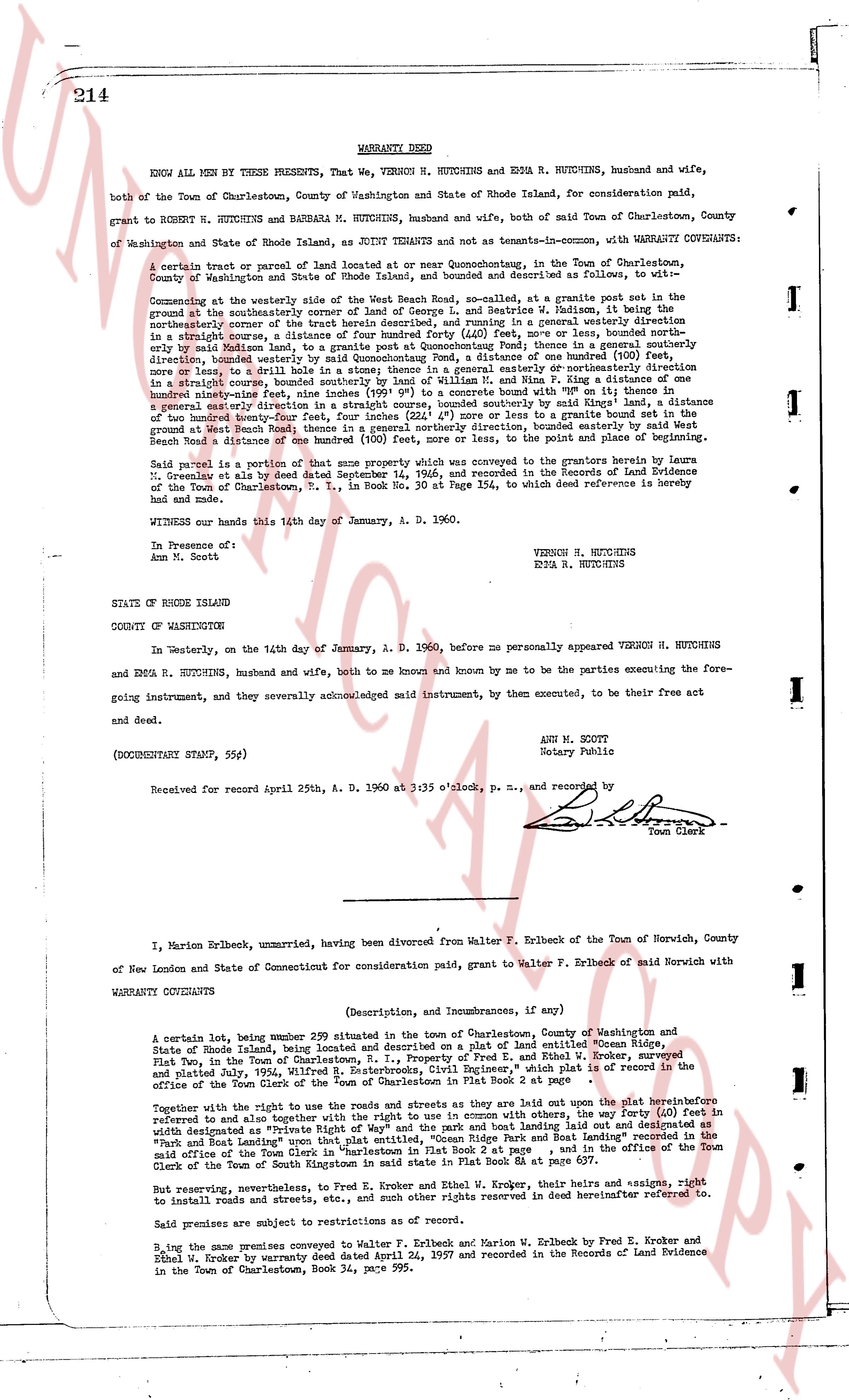
214
WARRANTY DEED
KNOW ALL MEN BY THESE PRESENTS, That We, VERNON H. HUTCHINS and EDNA R. HUTCHINS, husband and wife, both of the Town of Charlestown, County of Washington and State of Rhode Island, for consideration paid, grant to ROBERT H. HUTCHINS and BARBARA M. HUTCHINS, husband and wife, both of said Town of Charlestown, County of Washington and State of Rhode Island, as JOINT TENANTS and not as tenants-in-common, with WARRANTY COVENANTS:
A certain tract or parcel of land located at or near Quonochonticut, in the Town of Charlestown, County of Washington and State of Rhode Island, and bounded and described as follows, to wit:—
Commencing at the westerly side of the West Beach Road, so called, at a granite post set in the southeasterly corner of the property of [?] Hutchins, [?] Hutchins, [?] Hutchins, [?] Hutchins, at the northeasterly corner of the tract herein described, and running in a general westerly direction in a straight course, southerly 41° 15' W., a distance of 100 feet, northerly 89° 40' E., 100 feet, northerly 41° 15' E., said Marion land, to a granite post at Quonochonticut Pond thence in a general southerly direction, bounded westerly by said Marion land, to a granite post at the corner of one hundred (100) feet wide highway, bounded westerly by said highway, to a granite post in a general easterly or northeasterly direction one hundred ninety-four feet, in a straight course, bounded southerly by land of William and [?] Flan, a distance one hundred ninety-four feet, to a granite post at the corner of a stone wall bounded north with 89° 0' on thence in a general easterly direction in a straight course, bounded southerly by said King's land, to a granite post in the ground at West Beach Road, thence in a general northerly direction, bounded easterly by said West Beach Road a distance of 150 feet, to a granite post at the corner of a stone wall bounded northerly 89° 0' E.
Said parcel is a portion of that same property which was conveyed to the grantors herein by Laura M. Greenleaf et al by deed dated September 14, 1946, and recorded in the Records of Land Evidence of the Town of Charlestown, B. 30, P. 324, to which deed reference is hereby made and same.
WITNESS our hands this 14th day of January, A. D. 1960.
VERNON H. HUTCHINS
EDNA R. HUTCHINS
In Presence of:
Ann M. Scott
STATE OF RHODE ISLAND
COUNTY OF WASHINGTON
In Westerly, on the 14th day of January, A. D. 1960, before me personally appeared VERNON H. HUTCHINS and EDNA R. HUTCHINS, husband and wife, both to me known and known by me to be the parties executing the foregoing instrument, and they severally acknowledged said instrument, by them executed, to be their free act and deed.
ANN M. SCOTT
Notary Public
(DOCUMENTARY STAMP, 55¢)
Received for record April 27th, A. D. 1960 at 3:05 o'clock, p. m., and recorded by
[Signature]
Town Clerk
----
I, Marion Erlbeck, unmarried, having been divorced from Walter F. Erlbeck of the Town of Norwich, County of New London and State of Connecticut for consideration paid, grant to Walter F. Erlbeck said Norwich with WARRANTY COVENANTS
(Description, and Incumbrances, if any)
A certain lot, being number 299 situated in the Town of Charlestown, County of Washington and State of Rhode Island, being located and described as on a plat of land entitled "Ocean Ridge, Fox Point, in the Town of Charlestown, R. I.", property of Fred E. and Ethel W. Kroker, surveyed and platted July 1954, William R. Beutler, Registered Surveyor, said plat is of record in the office of the Town Clerk of the Town of Charlestown, indicated in Plat Book 8 at page 251.
Together with the right to use the roads and ways as are sety laid out upon the plat heretofore referred to and together with the right to use in common with others, the wells, pumps and feed dirt in wells designated as Private and Common on said plat, and the right of landing laid out and designated as "Pier and Boat Landing" upon that plat entitled, "Ocean Ridge and Boat Landing" recorded in the office of the Town Clerk of the Town of Charlestown, R. I., and in the office of the Town Clerk of the Town of South Kingstown in said state in Plat Book 8A at page 237.
But reserving, nevertheless, to Fred E. Kroker and Ethel W. Kroker, their heirs and assigns, right to install roads and streets, etc., and sums of money thus marked reserved in deed heretofore referred to.
Said premises are subject to restrictions as of record.
By the last conveyance conveyed to Walter F. Erlbeck and Marion V. Erlbeck by Fred E. Kroker and Ethel W. Kroker by warranty deed dated April 24, 1957 and recorded in the Records of Land Evidence in the Town of Charlestown, Book 34, page 595.
page 2 · read by Gemma vision
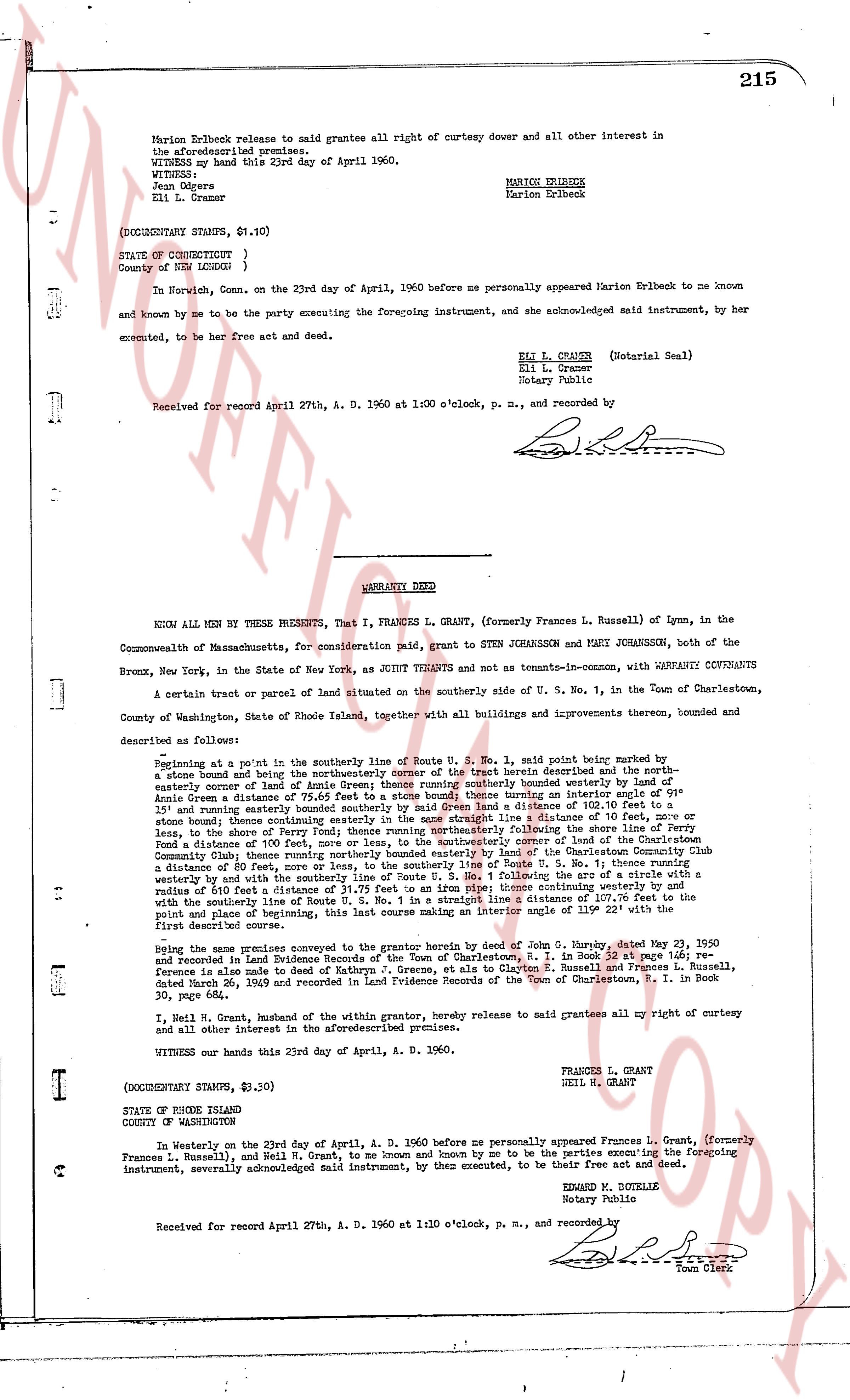
Marion Erlbeck release to said grantee all right of curtesy dower and all other interest in
the aforesaid premises.
WITNESS my hand this 23d day of April 1960.
WITNESS:
Jean Odgers
Eli L. Cramer
MARION ERLBECK
Marion Erlbeck
(DOCUMENTARY STAMPS, $1.10)
STATE OF CONNECTICUT }
County of NEW LONDON }
In New London, Conn. on the 23rd day of April, 1960 before me personally appeared Marion Erlbeck to me known
and known by me to be the party executing the foregoing instrument, and she acknowledged said instrument, by her
executed, to be her free act and deed.
ELI L. CRAMER (Notarial Seal)
Eli L. Cramer
Notary Public
Received for record April 27th, A. D. 1960 at 1:00 o'clock, p. m., and recorded by
----
WARRANTY DEED
KNOW ALL MEN BY THESE PRESENTS, That I, FRANCES L. GRANT, (formerly Frances L. Russell) of Lynn, in the
Commonwealth of Massachusetts, for consideration paid, grant to STEN JOHANSSON and MARTI JOHANSSON, both of the
Bronx, New York, in the State of New York, as JOINT TENANTS and not as tenants-in-common, with WARRANTY COVENANTS
A certain tract or parcel of land situated on the southerly side of Route U. S. No. 1, in the Town of Charlestown,
County of Washington, State of Rhode Island, together with all buildings and improvements thereon, bounded and
described as follows:
Beginning at a point in the southerly line of Route U. S. No. 1, said point being marked by a
stone bound and being the northerly corner of the street herein described and the north-
easterly corner of land of Annie Green land line running southerly almost easterly 100 feet to a
stone bound and thence a distance of 100 feet running easterly thence running an interior angle of 91°
15' and thence bounding easterly bounded by southerly line of a distance of 103.75 feet to a
stone bound thence continuing easterly bounded by southerly line a distance of 101 feet to a stone
bound and thence a distance of 100 feet running southerly to the shore line of Perry
Fond a distance of 100 feet running southerly to the southerly line of Route U. S. No. 1 thence running easterly
Community Club thence running northerly bounded easterly by land of the Charlestown Community Club
a distance of 100 feet, marked by a stone bound and thence running easterly to the southerly line of Route U. S. No. 1 thence
westerly by and with the southerly line of Route U. S. No. 1 following the arc of a circle with a
radius of 100 feet a distance of 100 feet running westerly thence running northerly extending westerly with
the southerly line of Route U. S. No. 1 in a straight line a distance of 107.75 feet to the start
and point of beginning, this last course making an interior angle 119° 22' with the first
described course.
Being the same premises conveyed to the grantor herein by deed of John G. Murphy, dated May 23, 1950
and recorded in Land Evidence Records of the Town of Charlestown, R. I. in Book 34, page 164; re-
conveyance is alleged to be from said John G. Murphy, et al to Clayton G. Russell and Frances L. Russell,
dated March 26, 1959 and recorded in Land Evidence Records of the Town of Charlestown, R. I. in Book
36, page 21.
I, Neil H. Grant, husband of the within grantor, hereby release to said grantees all my right of curtesy and
all other interest in the aforementioned premises.
WITNESS our hands this 23rd day of April, A. D. 1960.
FRANCES L. GRANT
NEIL H. GRANT
(DOCUMENTARY STAMPS, $3.30)
STATE OF RHODE ISLAND
COUNTY OF WASHINGTON
In Westerly on the 23rd day of April, A. D. 1960 before me personally appeared Frances L. Grant, (formerly
Frances L. Russell) and Neil H. Grant, to me known and known by me to be the parties executing the foregoing
instrument, severally acknowledged said instrument, by them executed, to be their free act and deed.
EDWARD M. BOTELLE
Rotary Public
Received for record April 27th, A. D. 1960 at 1:10 o'clock, p. m., and recorded by
[Signature]
Town Clerk
The page as recorded