The instrument's own words
page 1
272
LINE WALL - 114° 0 - 30'
LOT LINES - 90° WITH HIGHWAY
PAWATUCK RIVER
STONE POST
STONE POST
STONE POST
STONE POST
W.R.G. MYRTLE BARBER
MYRTLE E. BARGER
GARDNER
BOYES
WESTON GAVITT
R. SHERMAN
J. JORDAN
M. FLINT
A. SHINNMAN
W. POTTER
HOLLMAN
HILLMAN
KING ROADWAY
243'
125'
125'
125'
125'
125'
125'
125'
125'
125'
125'
125'
125'
125'
HIGHWAY
PERMANENT BOUND
ALL MEASUREMENTS
FROM THIS POINT
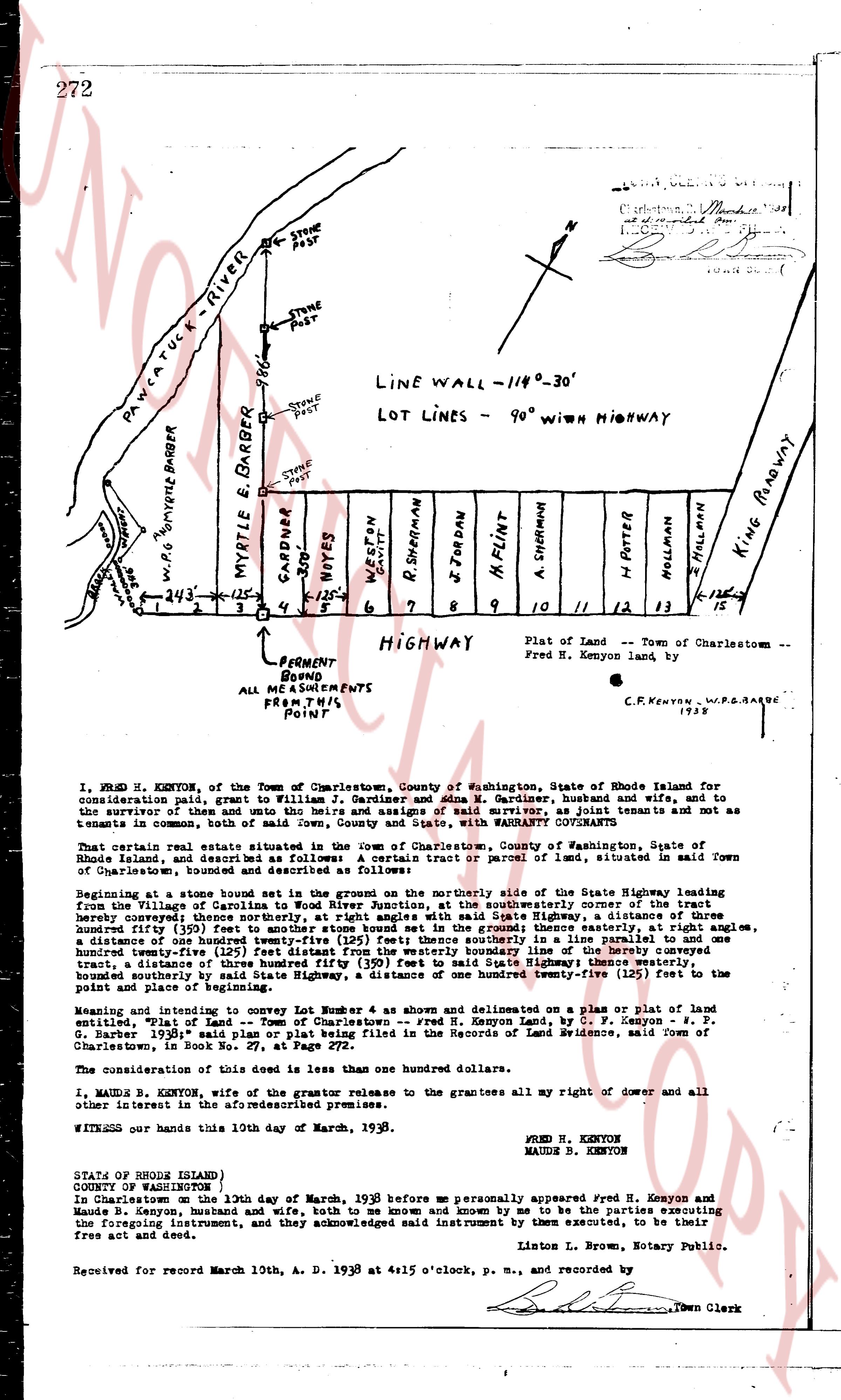
Plat of Land - Town of Charlestown -
Fred H. Kenyon land by f.
C.F. KENYON W.R.G. BARBER
1938
I, FRED B. KENYON, of the Town of Charlestown, County of Washington, State of Rhode Island for
consideration paid, grant to William J. Gardiner and Ada M. Gardiner, husband and wife, and to
the survivor of them and unto the heirs and assigns of said survivor, as joint tenants not as
tenants in common, both with full right of survivorship and appurtenant thereto, with WARRANTY conveyed:
That certain real estate situated in the town of Charlestown, County of Washington, State of
Rhode Island, and described as follows: A certain tract or parcel of land, situated in said Town
of Charlestown, bounded and described as follows:
Beginning at a stone bound set in the ground on the northerly side of the State Highway leading from
Charlestown to Westerly, Catania’s corner, at the southeasterly corner of the State Highway leading from
hereby conveyed; thence southerly, at right angles with said State Highway, a distance of one hundred
twenty-five (125) feet to the southerly bound of the ground thence easterly, at right angles,
a distance of one hundred twenty-five (125) feet then southerly in a parallel line to and bound
the southerly bound of the ground thence westerly, at right angles, a distance of one hundred twenty-
tract, a distance of three hundred fifty (350) feet to said State Highway, a distance one twenty-five (125) feet to the
point and place of beginning.
Meaning and intending to convey Lot Number 6 shown and delineated on a Plan or Plat entitled
"Plat of Land - Town of Charlestown - Fred H. Kenyon Land, by C. F. Kenyon & W. R. G.
Barber 1938" said plan or plat being filed with the Records of Land Evidence, situated in said Town
of Charlestown, in Book no. 27, at Page 272.
The consideration of this deed is less than one hundred dollars.
I, MAUDE B. KENYON, wife of the grantor releases to the grantees all my right of dower and all
other interest in the above mentioned premises.
WITNESS our hands this 10th day of March, 1938.
FRED H. KENYON
MAUDE B. KENYON
STATE OF RHODE ISLAND
COUNTY OF WASHINGTON
In Charlestown, the 10th day of March, 1938 before me personally appeared Fred H. Kenyon and
Maude B. Kenyon, husband and wife, both to me known and by me known to be the parties executing
the foregoing instrument, and they acknowledged said instrument by them executed, to be their
free act and deed.
Linton L. Brown, Notary Publics.
Received for record March 10th, A. D. 1938 at 4:15 o'clock, p. m., and recorded by
Town Clerk
The page as recorded