The instrument's own words
page 1 · read by Gemma vision
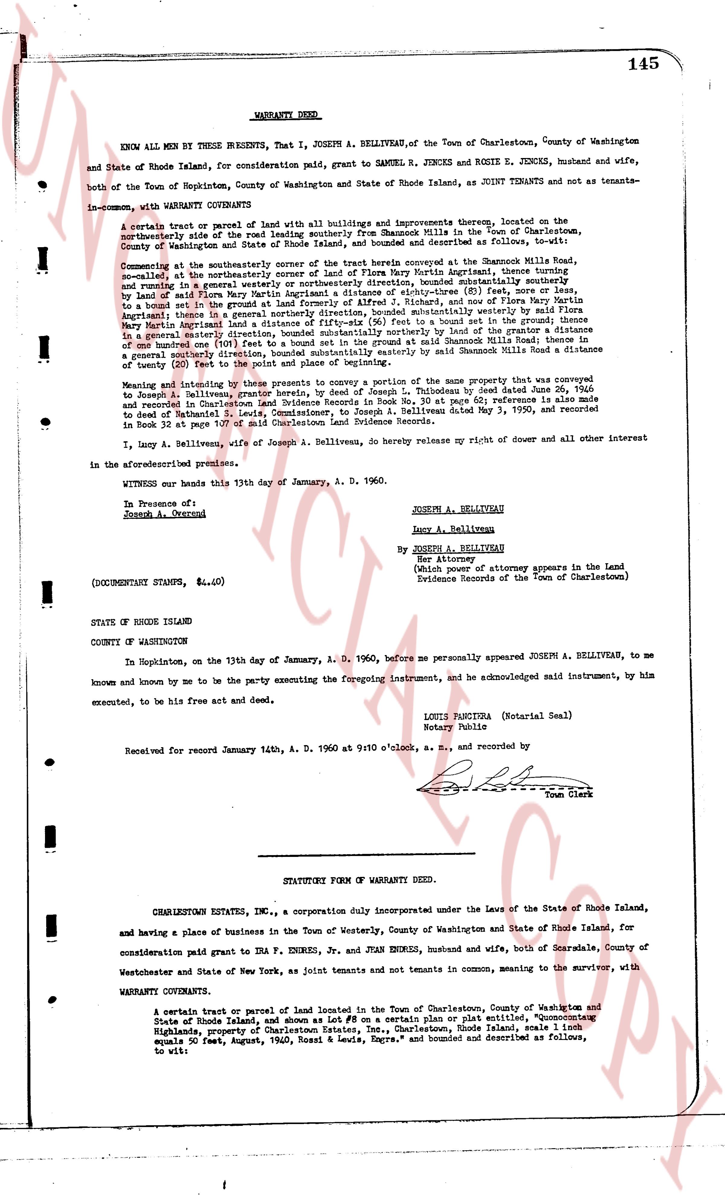
145
WARRANTY DEED.
KNOW ALL MEN by THESE PRESENTS, That I, JOSEPH A. BELLIVEAU, of the Town of Charlestown, County of Washington and State of Rhode Island, for consideration paid, grant to SAMUEL R. JENCKS and ROSIE E. JENCKS, husband and wife, both of the Town of Hopkinton, County of Washington and State of Rhode Island, as JOINT TENANTS and not as tenants-in-common, with WARRANTY COVENANTS
A certain tract or parcel of land with all buildings and improvements thereon, located on the northeasterly side of the road running southeast from the Rhode Island turnpike in the Town of Charlestown, County of Washington and State of Rhode Island, bounded and described as follows, to wit:
Commencing at the southeasterly corner of the tract herein conveyed at the Shannonick Mills Road, s.e., at the northeasterly corner of the tract of Flora Mary Martin Angrisani, thence turning and running generally in a westerly direction along the said tract of Flora Mary Martin Angrisani, bounded southeasterly by land of said Flora Mary Martin Angrisani a distance of eighty-three (83) feet, or more or less, to a stone wall, and thence running generally in a northerly direction, and once more by land in the grant to Flora Mary Martin Angrisani thence in a generally northerly direction, bounded southeasterly by land of the grantor a distance of one hundred forty (140) feet to a stone wall, and thence running generally in a southeasterly direction of one hundred one (101) feet to a stone wall, and thence running generally in a southeasterly direction along said Shannonick Mills Road a distance of twenty (20) feet to the point and place of beginning.
Meaning and intending by these presents to convey a portion of the same property that was conveyed to Joseph A. Belliveau, president of Charlestown Estates, Inc., by Joseph L. Thibaudeau by deed dated June 26, 1956 and recorded in Charlestown Land Evidence Books in Book 30 at page 62; reference is also made to deed to said Joseph A. Belliveau by Joseph L. Thibaudeau by deed dated May 3, 1950, and recorded in Book 32 at page 107 of said Charlestown Land Evidence Records.
I, Lucy A. Belliveau, wife of Joseph A. Belliveau, do hereby release my right of dower and all other interest in the aforesaid premises.
WITNESS our hands this 13th day of January, A. D. 1960.
In Presence of: JOSEPH A. BELLIVEAU
Joseph A. Overend Lucy A. Belliveau
By JOSEPH A. BELLIVEAU
Her Attorney
(Which power of attorney appears in the Land
Evidence Records of the Town of Charlestown)
(DOCUMENTARY STAMPS, $ 4.40)
STATE OF RHODE ISLAND
COUNTY OF WASHINGTON
In Hopkinton, on the 13th day of January, A. D. 1960, before me personally appeared JOSEPH A. BELLIVEAU, to me known and known by me to be the party executing the foregoing instrument, and he acknowledged said instrument, by him executed, to be his free act and deed.
LOUIS PANICIA (Notarial Seal)
Notary Public
Received for record January 14th, A. D. 1960 at 9:10 o'clock, a. m., and recorded by
[Signature] Town Clerk
----
STATUTORY FORM OF WARRANTY DEED.
CHARLESTOWN ESTATES INC., a Corporation duly incorporated under the Laws of the State of Rhode Island, and having a place of business in the Town of Westerly, County of Washington and State of Rhode Island, for consideration paid grant to IRA F. ENDRES, Jr. and JEAN ENDRES, husband and wife, both of Scarsdale, County of Westchester and State of New York, as joint tenants and not tenants in common, meaning to the survivor, with WARRANTY COVENANTS
A certain tract or parcel of land located in the Town of Charlestown, County of Washington and State of Rhode Island, and shown as Lot # 8 on a certain plan or plat entitled, "Quoconctogue Highlands, property of Charlestown Estates, Inc., Charlestown, Rhode Island, scale 1 inch equals 50 feet, August, 1940, Rossi & Lewis, Engrs." and bounded and described as follows, to wit:
page 2 · read by Gemma vision
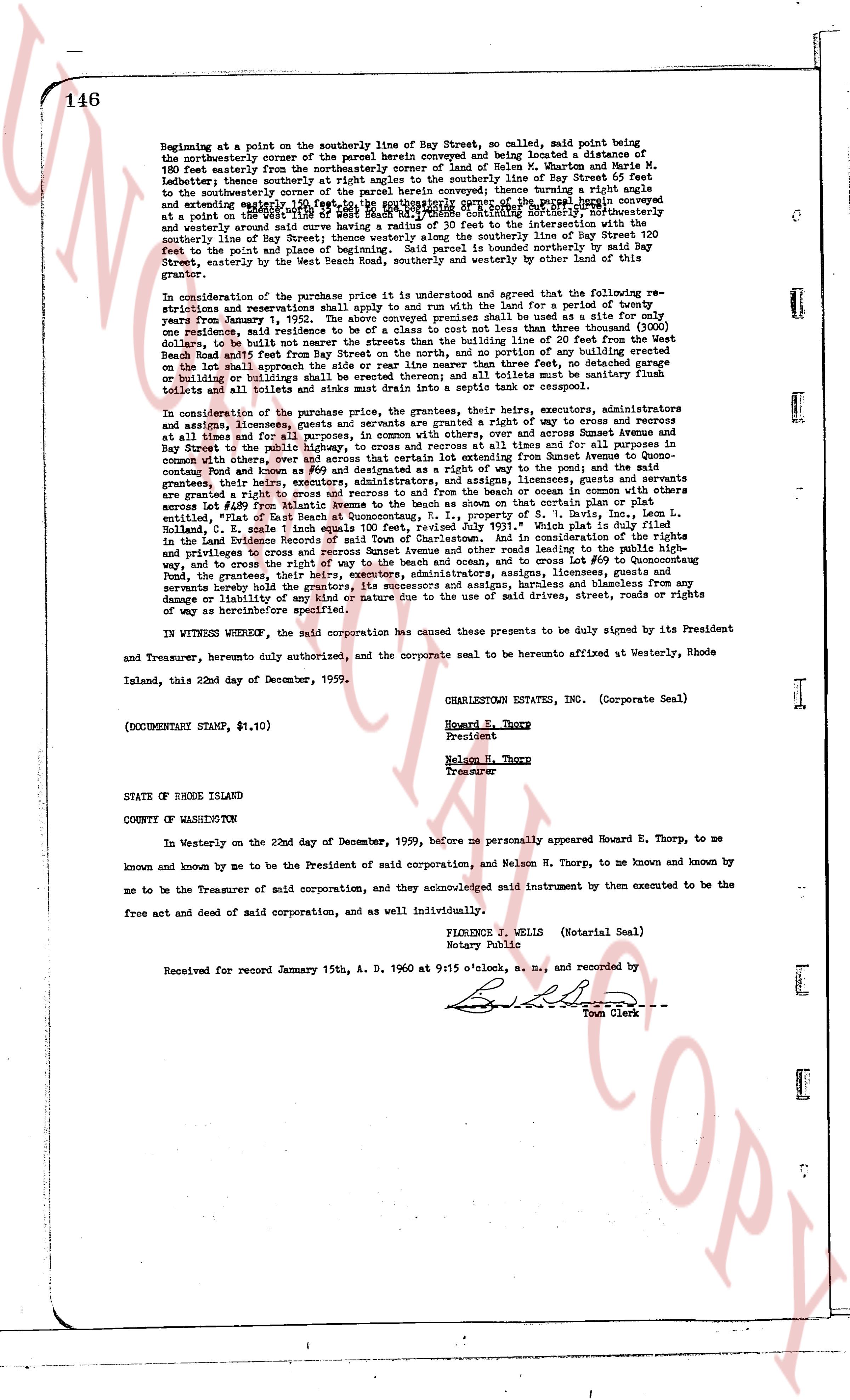
146
Beginning at a point on the southerly line of Bay Street, so called, said point being the southeasterly corner of the parcel herein conveyed and being located a distance of 180 feet easterly from the northeasterly corner of land of Helen M. Wharton and Maria M. Lehane; thence southerly a distance of 180 feet to the southerly line of Bay Street so called and to the southeasterly corner of the parcel herein conveyed; thence turning a right angle and extending westerly along the southerly line of Bay Street to a point on a regular curve having a radius of 30 feet the center of said curve being located southeasterly and westerly from a point on the southerly line of Bay Street 180 feet southeasterly and westerly from said curve having a radius of 30 feet the center of said curve being located southeasterly and westerly from a point on the southerly line of Bay Street 180 feet southeasterly and westerly from said curve having a radius of 30 feet the center of said curve being located southeasterly and westerly from a point on the southerly line of Bay Street 180 feet southeasterly and westerly from said curve having a radius of 30 feet the center of said curve being located southeasterly and westerly from a point on the southerly line of Bay Street 180 feet southeasterly and westerly from said curve having a radius of 30 feet the center of said curve being located southeasterly and westerly from a point on the southerly line of Bay Street 120 feet to the point and place of beginning. Said parcel is bounded northerly by said Bay Street, easterly by land of Charlestown Estates Inc. and westerly by other land of the grantor.
The grantor further covenants with the purchaser that the price indicated in the premises of this instrument is and shall remain as agreed and that the refunding of the reservations and restrictions shall apply to and run with the land for a period of twenty years from January 1, 1960. The above conveyed premises shall be used as a single family residence, and neither the grantee nor his heirs shall build any house costing less than three thousand ($3000) dollars, to be built not nearer the streets than the building line of 20 feet from the West boundary of the lot and not nearer the side lines than 10 feet; no portion of any building shall be erected on the lot that shall approximate the side or rear line no nearer than three feet, no detached garage or building on the lot shall be closer than 10 feet to the side line; all buildings shall be sanitary and equipped with toilets and toilets and sinks made to drain into a septic tank or cess pool.
In consideration of the purchase price, the grantees, their heirs, executors, administrators and assigns, forever have and hold the premises with a right of way for ingress and egress and return at all times and for all purposes, in common with others, over and across Sunset Avenue and across Bay Street to the public highway and road known as #9 and designated as such on the plat and map of the town of Charlestown and go over, and across that certain lot extending from Sunset Avenue to Quonocutong Beach and road known as #9 and designated as such on the plat and map of the town of Charlestown, the grantees, their heirs, executors, administrators, and assigns, licensees, guests and servants are granted a right to cross and recross to and from the beach and ocean, in common with others across the lot numbered #10 on the aforementioned plat and map, and the right of way is further described, entitled, "Right of Eas. Beach at Quonocutong N. E., property of A. J. Daly, Esq., located in the town of Charlestown, Rhode Island, in Plat Book 1, page 10, which plat is duly filed in the Land Evidence Records of said Town of Charlestown. And in consideration of the rights of the grantees, the grantees, their heirs, executors, administrators, and assigns, licensees, guests and servants hereby hold the grantors, its successors and assigns, harmless and blameless from any damages or liability of any or every nature due to the use of said drives, streets, roads or rights of way as hereinbefore specified.
IN WITNESS WHEREOF, the said corporation has caused these presents to be duly signed by its President and Treasurer, hereunto duly authorized, and the corporate seal to be hereunto affixed at Westerly, Rhode Island, this 22nd day of December, 1959.
CHARLESTOWN ESTATES, INC. (Corporate Seal)
Howard E. Thorp
President
Nelson H. Thorp
Treasurer
(DOCUMENTARY STAMP, $1.10)
STATE OF RHODE ISLAND
COUNTY OF WASHINGTON
In Westerly on the 22nd day of December, 1959, before me personally appeared Howard E. Thorp, to me known and known by me to be the President of said corporation, and Nelson H. Thorp, to me known and known by me to be the Treasurer of said corporation, and they acknowledged said instrument by them executed to be the free act and deed of said corporation, and as individuals individually.
FLORENCE J. WELLS (Notarial Seal)
Notary Public
Received for record January 15th, A. D. 1960 at 9:15 o'clock, a. m., and recorded by
[Signature]
Town Clerk
The page as recorded