The instrument's own words
page 1 · read by Gemma vision
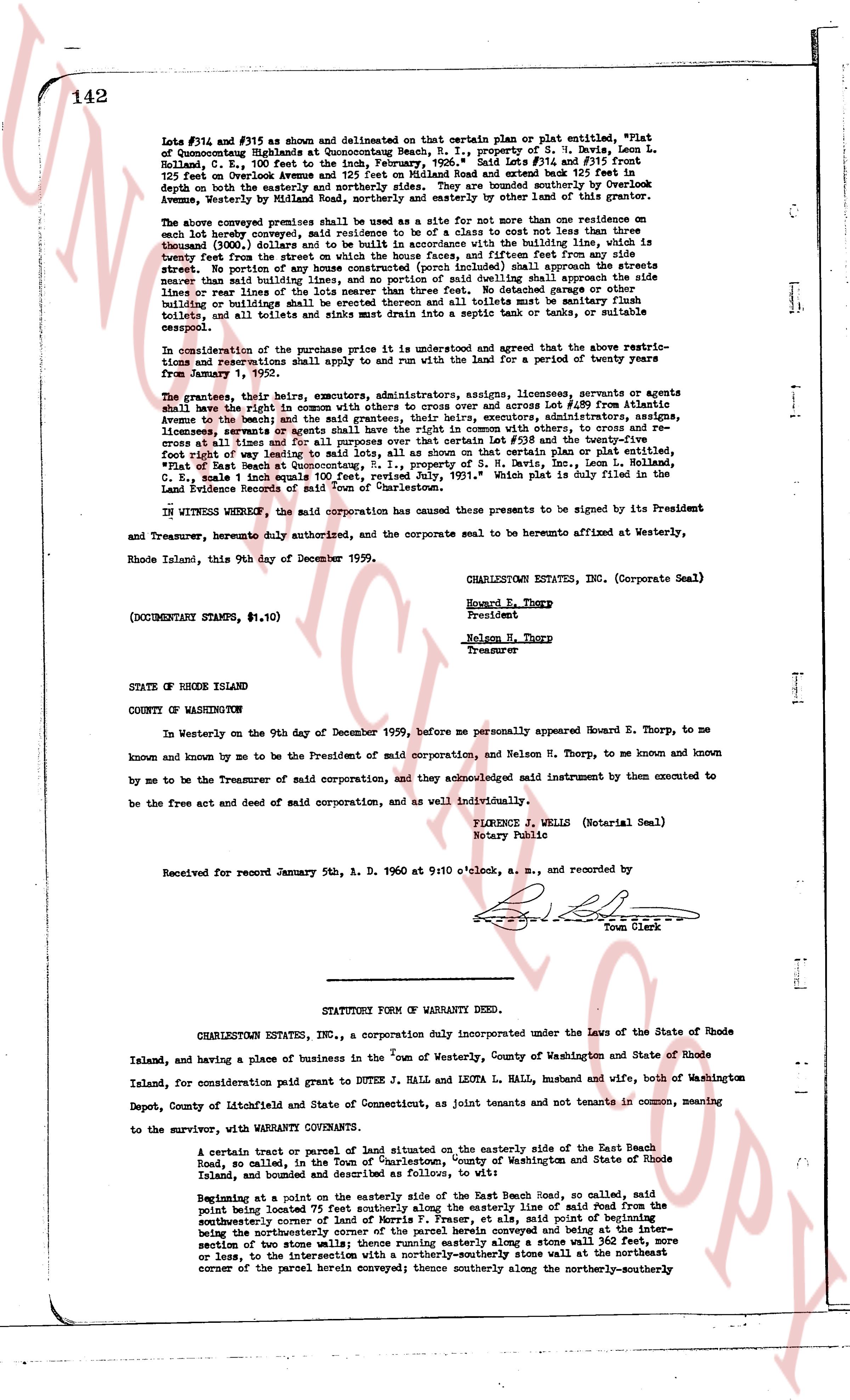
142
Lots #734 and #735 as shown and delineated on that certain plan or plat entitled, "Plat of
Conocomuncog Highlands at Conocomuncog Beach, R. I., property of S. H. Davis, Leon L.
Holland, C. E., 100 feet to the inch, February, 1957" said Lot #734 and Lot #735 together
125 feet west toward Avenue A and 125 feet south toward Beach Road and extend back 125 feet in
depth on both the easterly and northerly sides. They are bounded southerly over by Lookout
Avenue, westerly by Lot #733 and northerly and easterly by other land of the grantor.
The above conveyed premises shall be used as a site for not more than one residence on one
each lot hereby conveyed, said residence to be a life to a class not less than thirty three
inches from the ceiling of the highest floor, and together with the building site, the setback
is twenty feet from the street on which the house faces, and fifteen feet from any side
street or alley. No building shall be erected, nor shall any street nearer than the side streets
nearer than said building lines, and no portion of said dwelling shall approach the side
lines or rear lines of the lot less than ten feet. No tobacco crops or other noxious
buildings or plantings shall be erected thereon and all toilets must be sanitary flush
toilets, and all toilets and sinks drain into a septic tank and cess pool, or suitable
sewer.
In consideration of the purchase price it is understood and agreed that the above restric-
tions and reservations shall apply to and run with the land for a period of twenty years
from January, 1960.
The grantors, their heirs, executors, administrators, assigns, licensees, servants or agents
shall have the right in common with others to cross over and across Lot #690 from Avenue A
towards the beach, and the grantors, their heirs, executors, administrators, assigns, licensees,
agents or servants shall have the right in common with others, to cross and to re-
cross at all times and for all purposes, over and across Lots #698 and twenty-three feet wide
foot right of way leading to said lots, all as shown on that certain plan or plat entitled,
"Plat of Beach Road, Conocomuncog Beach, R. I., property of S. H. Davis, Leon L.
Holland, C. E., scale 1 inch equals 100', revised July, 1957," which plat is duly filed in the
Land Evidence Records of said Town of Charlestown.
IN WITNESS WHEREOF, the said corporation has caused these presents to be signed by its President
and Treasurer, heretofore duly authorized, and the corporate seal to be hereunto affixed at Westerly,
Rhode Island, this 9th day of December 1959.
CHARLESTOWN ESTATES, INC. (Corporate Seal)
Howard E. Thorp
President
Nelson H. Thorp
Treasurer
(DOCUMENTARY STAMPS, $1.10)
STATE OF RHODE ISLAND
COUNTY OF WASHINGTON
In Westerly on the 9th day of December 1959, before me personally appeared Howard E. Thorp, to me
known and known by me to be the President of said corporation, and Nelson H. Thorp, to me known and known
by me to be the Treasurer of said corporation, and they acknowledged said instrument by them executed to
be the free act and deed of said corporation, and as well individually.
FLORENCE J. WELLS (Notarial Seal)
Notary Public
Received for record January 5th, A. D. 1960 at 9:10 o'clock, a. m., and recorded by
[Signature]
Town Clerk
----
STATUTORY FORM OF WARRANTY DEED.
CHARLESTOWN ESTATES, INC., a corporation duly incorporated under the Laws of the State of Rhode
Island, and having a place of business in the Town of Westerly, County of Washington and State of Rhode
Island, consideration paid grant to DUTEE J. HALL and LEOTA L. HALL, husband and wife, both of Washington
Depot, County of Litchfield and State of Connecticut, as joint tenants and not tenants in common, waiting
to the survivor, with WARRANTY CONVEYANCE.
A certain tract or parcel of land situated on the easterly side of the East Beach Road,
so called, in the Town of Charlestown, county of Washington and State of Rhode
Island, and bounded and described as follows to wit:
Beginning at a point on the easterly side of the East Beach Road, so called, said
point being located 75 feet southerly along the easterly line of said Road from the
southeasterly corner of lot #690 on Fraser's Plat, at said point of beginning
being the northwesterly corner of the parcel herein conveyed and being at the inter-
section of two stone walls, thence running along a stone wall 110 feet or more
or less, to the intersection with a northerly-southeastly stone wall at the northeast
corner of the parcel herein conveyed; thence southerly along the northerly-southeasterly
page 2 · read by Gemma vision
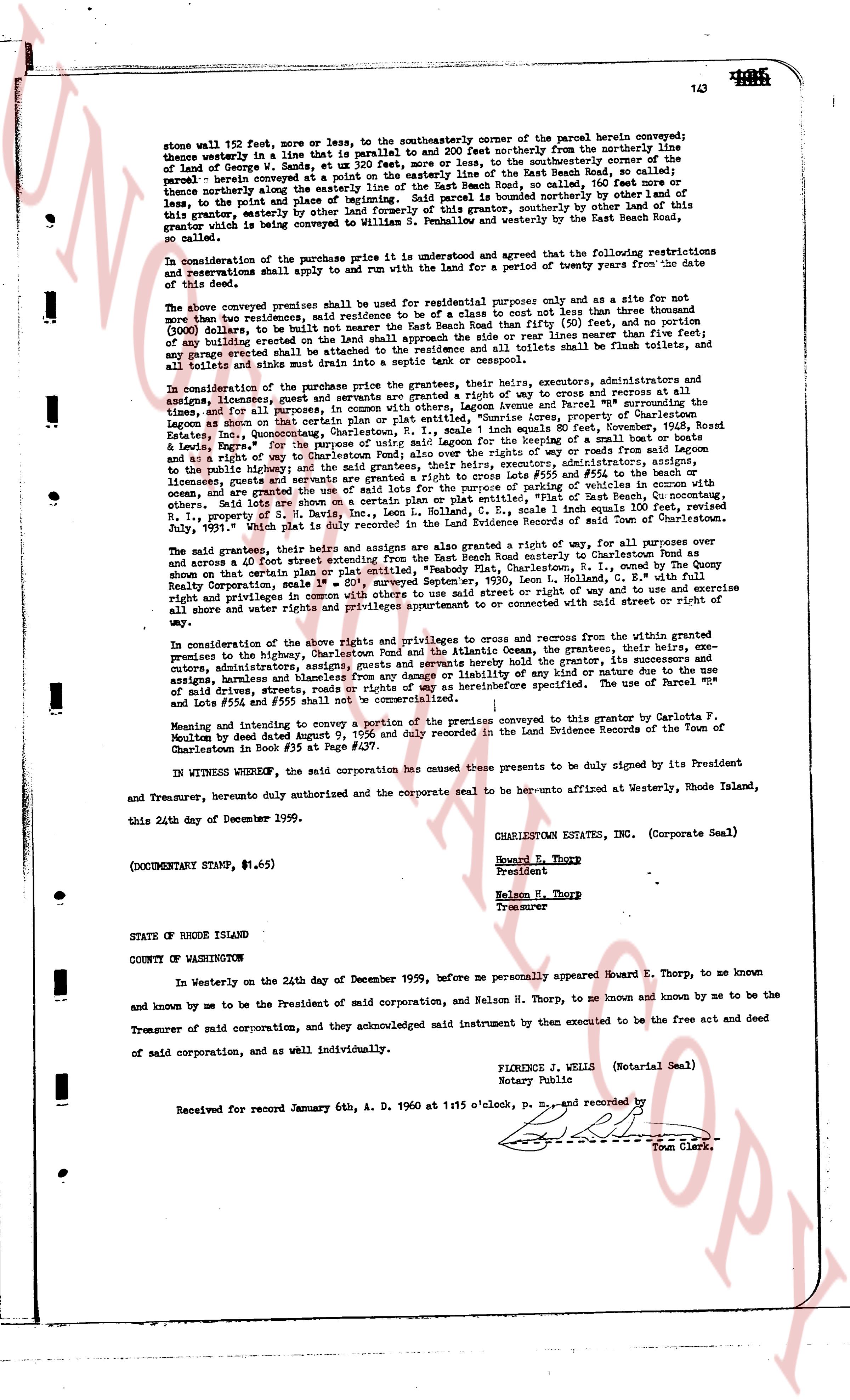
stone wall 152 feet, more or less, to the southeasterly corner of the parcel herein conveyed;
thence westerly in a line that is parallel to and 200 feet northerly from the northerly line
of land of George W. Sands, and ut sum 320 feet, more or less, to the southerly boundary of the
parcel; thence northerly along the easterly line of the East Beach Road, so called, 160 feet more or
less, to a point marked by a carved "X" in a stone boundary marker bounded by other of the
same property, easterly by other land formerly of William S. Fellows, and westerly by the East
Beach Road, so called.
In consideration of the purchase price this indenture it is agreed and that the following restrictions
and reservations shall apply to and run with the Land for a period of twenty years from the date
of this deed:
The above conveyed premises shall be used for residential purposes only and as a site for not
more than two residences, said residences to be of a type and cost not less than three thousand
($3,000) dollars to be built on a line parallel to the East Beach Road than fifty (50) feet, and no portion
of any building erected on the land shall approach the side or rear lines nearer than twenty (20)
feet, except porches attached shall be permitted to approach within ten (10) feet, all toilets and
all toilets and sinks shall run directly into a septic tank or cesspool etc.
In consideration of the purchase price the grantees, their heirs, executors, administrators and as
signs, forever, linearly, limited and qualified, shall have a right of way to cross and re-cross at all
times, and for all purposes, in common, with others Legon Avenue and Parcel B, property of
Charlestown Estates, Inc., Quonochontaug, Charlestown, R.I., No. 1, some 1 inch equals 80 feet,
November, 1928, Record
Book 24, page 142, filed 11/12/28, in a line bearing N. 31° E. crossing in a bevel of 5 miles from said
Legon Avenue and in a right of way to Charlestown Pond; also over the ways or rights of way from said
Legon Avenue and in a right of way to Charlestown Pond, the grantees, their heirs, executors, administrators
to the public highway, and the right of way to the beach, including the right of putting in toilets, and
ocean, and are granted a right of way over the land marked as cross plan or emplot "Plat", of East Beach Rd,
Quonochontaug, Charlestown, R.I., No. 1, some 1 inch equals 80 feet, November, 1928, Record
B. 24, p. 142, filed 11/12/28, said right is duly recorded in the Land Evidence Records of Town of Charlestown.
The said grantees, their heirs and assigns are also granted a right along a right of way, for all purposes over
and across a 40 foot street extending from the East Beach Road to the easterly boundary of the grantees
premises on the plat marked "Plat", Embodied, East Beach Plat, Charlestown, R.I., coined by the Coney
Realty Corporation made September, 1950, Item 1, scaled 1 inch = 100 feet, and the right of way and to use and
exercise right and privileges in the same, and the right of way and to use and exercise
all shore water and rights privileges appurtenant to or connected with said street or right of
way.
In consideration of the above rights and privileges to cross and re-cross from within the granted
premises to the highway, Charlestown Pond and the Atlantic Ocean, the grantees, their heirs, ex-
cutors, administrators, successors and assigns, and all their agents, servants, hirelings and employees,
assigns, harmless and blameless from any damage or liability of any kind or nature due to the use
of said rights, streets, ways and privileges hereinbefore specified. The use of Parcel nr
lets #554 and #555 shall not be commercialized.
Meaning and intention to convey a portion of the premises conveyed to this grantor by Carolina T.
Newton by Deed dated June 9, 1959, and duly recorded in the Land Evidence Records of the Town of
Charlestown in Book #35 at Page #297.
IN WITNESS WHEREOF, the said corporation has caused the present these to be duly signed by its President
and Treasurer, hereby duly authorized and the corporate seal to be hereto affixed at Westerly, Rhode Island,
this 24th day of December 1959.
CHARLESTOWN ESTATES, INC. (Corporate Seal)
Howard E. Thorp
President
Nelson M. Thorp
Treasurer
(DOCUMENTARY STAMP, $1.65)
STATE OF RHODE ISLAND
COUNTY OF WASHINGTON
In Westerly on the 24th day of December 1959, before me personally appeared Howard E. Thorp, to me known
and known by me to be the President of said corporation and, Nelson M. Thorp, to me known and known by me to be
Treasurer of said corporation, and they acknowledged said instrument by them executed to be the free act and deed
of said corporation, and as well individually.
FLORENCE J. WELLS (Notarial Seal)
Notary Public
Received for record January 6th, A. D. 1960 at 1:15 o'clock, P. M., and recorded by
[Signature]
Town Clerk.
The page as recorded