The Deed Walker · From Ninigret · Charlestown, Rhode Island land evidence, 1738 to today
Trail: 5982@36/562

8/24/1961 · RELEASE · book 36 page 562 doc 5982@36/562

From INDUSTRIAL NATIONAL BANK OF PROVIDENCE
To JACKSON MARION T
Premises none · Tract bounded by Route U.S. 1 and Concrete Mud Cove (Charlestown, Concrete Mud Cove, Wendover Lane)
Also on this page: DEED SPORTSMAN'S CORNERS INC

Back — where this land came from

mortgage Henry and Elizabeth Hoxsie book 36 p 562 Charlestown
“recorded in the (Land Evidence)(Real Estate Mortgage) Records in such Town of Charlestown in Mortgage Book 36 at page 562”
◀ Follow back 1959 · DEED · HOXSIE ELIZABETH B; HOXSIE W MONROE → SPORTSMAN'S CORNERS INC · book 36 p 562
read by: gemma

The grantor's earlier acquisitions, by name — the man, not necessarily this land

◀ 1961 · MORTGAGE · CYR MARION G → INDUSTRIAL NATIONAL BANK OF PROVIDENCE · book 38 p 28
◀ 1961 · MORTGAGE · BROPHY JANET G; CUNNEEN SALLY S → INDUSTRIAL NATIONAL BANK OF PROVIDENCE · book 38 p 29
◀ 1961 · MORTGAGE · FRANKLIN JOHN W; FRANKLIN MARY T → INDUSTRIAL NATIONAL BANK OF PROVIDENCE · book 38 p 40
◀ 1961 · MORTGAGE · BLIVEN BRYAN F; BLIVEN GAIL P → INDUSTRIAL NATIONAL BANK OF PROVIDENCE · book 37 p 503
◀ 1961 · MORTGAGE · ALMY LEONARD A; ALMY MARILYN L → INDUSTRIAL NATIONAL BANK OF PROVIDENCE · book 37 p 562
◀ 1961 · MORTGAGE · GRAICHEN RICHARD SLATER → INDUSTRIAL NATIONAL BANK OF PROVIDENCE · book 37 p 563
◀ 1961 · MORTGAGE · GRAICHEN BESSIE W; GRAICHEN LOUIS S → INDUSTRIAL NATIONAL BANK OF PROVIDENCE · book 37 p 566
◀ 1961 · MORTGAGE · FOSTER CONSTANCE M; FOSTER VIRGIL T → INDUSTRIAL NATIONAL BANK OF PROVIDENCE · book 37 p 568
◀ 1961 · MORTGAGE · DURHAM THOMAS E → INDUSTRIAL NATIONAL BANK OF PROVIDENCE · book 37 p 572
◀ 1961 · MORTGAGE · PUCELLA ANTHONY N; PUCELLA ROYALIE J → INDUSTRIAL NATIONAL BANK OF PROVIDENCE · book 37 p 574
◀ 1961 · MORTGAGE · RYAN EDWARD P; RYAN EVELYN → INDUSTRIAL NATIONAL BANK OF PROVIDENCE · book 37 p 587
◀ 1961 · MORTGAGE · CHAPMAN HAROLD L → INDUSTRIAL NATIONAL BANK OF PROVIDENCE · book 37 p 589
◀ 1961 · MORTGAGE · TURNER CHARLES E; TURNER MILDRED B → INDUSTRIAL NATIONAL BANK OF PROVIDENCE · book 37 p 590
◀ 1961 · MORTGAGE · FERRETTI MARGARET I; FERRETTI SAMUEL A → INDUSTRIAL NATIONAL BANK OF PROVIDENCE · book 37 p 607

Forward — where this land went

The grantee's later conveyances, by name — the man, not necessarily this land; the one that cites this deed as its source is the land

▶ 1961 · DEED · JACKSON HAROLD C; JACKSON MARION T → REED EDNA MAE; REED LEWIS W · book 38 p 82
▶ 1961 · AGREEMENT · JACKSON HAROLD C; JACKSON MARION T → CHARLESTOWN TOWN OF · book 38 p 167
▶ 1961 · DEED · JACKSON HAROLD C; JACKSON MARION T → CHARLESTOWN TOWN OF · book 38 p 173
▶ 1962 · DEED · JACKSON HAROLD C; JACKSON MARION T → GLASKO EVA M; GLASKO WILLIAM H · book 38 p 403
▶ 1965 · MORTGAGE · JACKSON HAROLD C; JACKSON MARION T → CONSOLIDATED MORTGAGE CO · book 40 p 546
▶ 1965 · ASSIGNMENT · CONSOLIDATED MORTGAGE CO; JACKSON HAROLD C; JACKSON MARION T → FINANCIAL INSTITUTION OF AMERICA INC · book 40 p 551
▶ 1966 · MORTGAGE · JACKSON HAROLD C; JACKSON MARION T → WASHINGTON TRUST COMPANY · book 41 p 128
▶ 1969 · AGREEMENT · JACKSON MARION T → AMERICAN TELEPHONE AND TELEGRAPH CO · book 43 p 224
▶ 1972 · DEED · JACKSON HAROLD C; JACKSON MARION T → HUNTE SHARON E · book 46 p 384
▶ 1975 · DEED · JACKSON MARION T → JACKSON MARION T; JACKSON HAROLD C · book 53 p 313

Today — the assessor's parcel

MEADOW LANE map 5 lot 23
owner of record: SPORTSMENS COVE ASSOCIATES · POT DEVEL
the assessor cites book/page 0036/0562 (SPORTSMAN'S CORNERS, INC, 03/30/1959)
08/11/1989SPORTSMENS COVE ASSOCIATESbook 107 p 514
10/14/1988ACHIN DANIEL R + MAURA L MCCARTHYbook 102 p 879
08/12/1986KELLS, JOHN M SR & MARGARETbook 86 p 999
03/30/1959SPORTSMAN'S CORNERS, INCbook 36 p 562
the assessor's card ↗
20 SPORTSMAN ROAD - RANGE map 5 lot 14
owner of record: CHARLESTOWN TOWN OF · MNCPL MDL-00
the assessor cites book/page 0036/0562 (HOXSIE, W MONROE & ELIZABETH B, 01/01/1900)
02/16/1990CHARLESTOWN TOWN OFbook 110 p 307
12/22/1988KELLS, MARGARET Lbook 103 p 824
08/10/1982KELLS, JOHN SR & MARGARETbook 68 p 557
01/01/1900HOXSIE, W MONROE & ELIZABETH Bbook 36 p 562
the assessor's card ↗
POST ROAD map 5 lot 24
owner of record: RHODE ISLAND STATE OF {DEM} · STATE MDL-00
the assessor cites book/page 0036/0562 (RHODE ISLAND, STATE OF, 01/01/1900)
01/27/2005RHODE ISLAND STATE OF {DEM}book 275 p 386
10/21/2002RHODE ISLAND, STATE OF + PROV Pbook 224 p 566
01/01/1900RHODE ISLAND, STATE OFbook 36 p 562
the assessor's card ↗

The instrument's own words

page 1 · read by Gemma vision
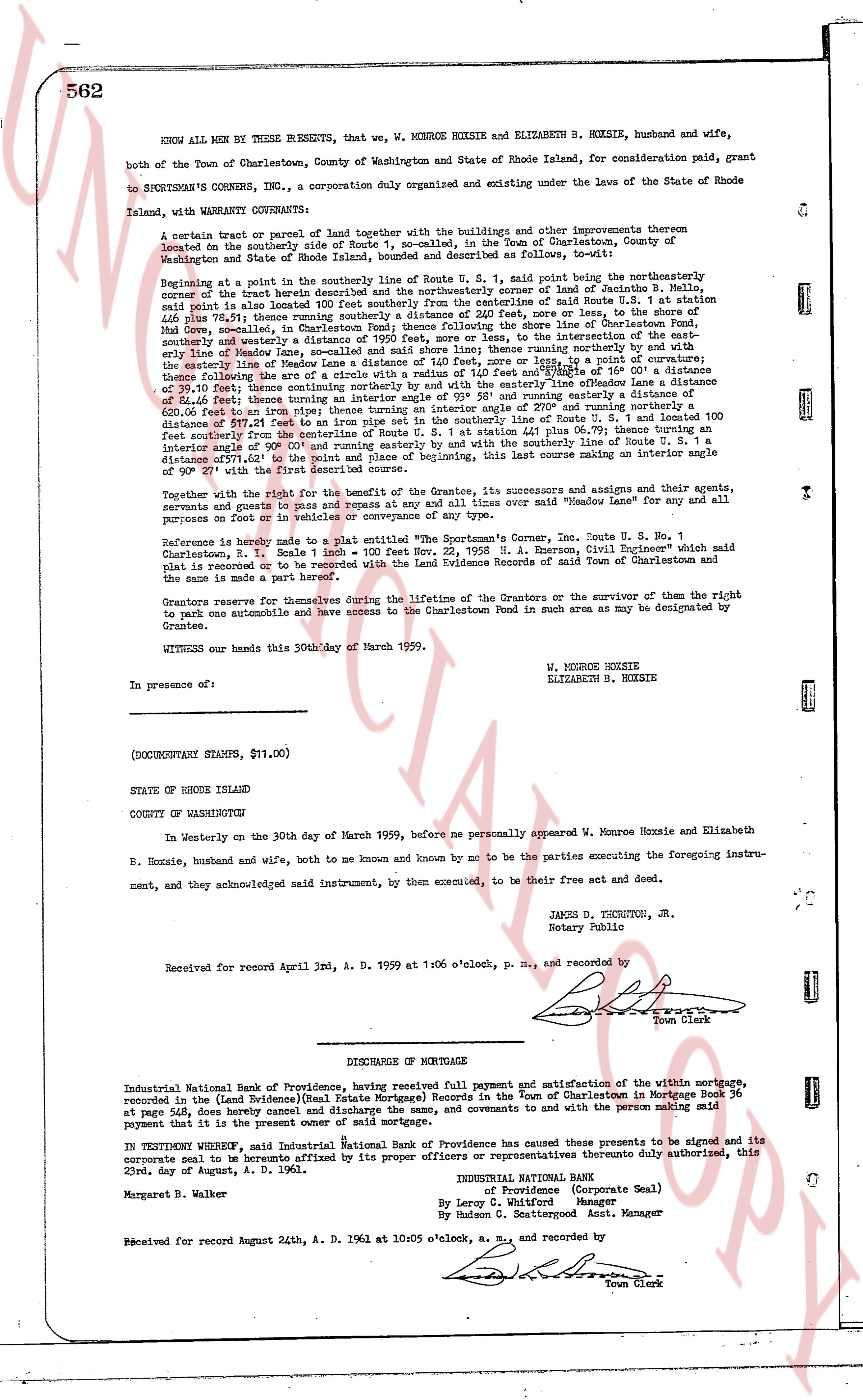
562 KNOW ALL MEN BY THESE PRESENTS, that we, W. MERROE HOXSIE and ELIZABETH B. HOXSIE, husband and wife, both of the Town of Charlestown, County of Washington and State of Rhode Island, for consideration paid, grant to SPORTMAN'S CORNERS, INC., a corporation duly organized and existing under the laws of the State of Rhode Island, with WARRANTY CONVEYANCE: A certain tract or parcel of land together with the buildings and other improvements thereon bounded on the southerly side of Route U. S. 1, so-called, in the Town of Charlestown, County of Washington and State of Rhode Island, bounded and described as follows, to-wit: Beginning at a point in the southerly line of Route U. S. 1, said point being the northeasterly corner of the tract herein conveyed and being a point in the boundary of land of Zenobia B. Mell, said point also is located about 100 feet southerly from the centerline of said Route U. S. 1 at station 446 plus 78.51; thence running southerly a distance of 227 feet, more or less, following the shore line of Concrete, Mud Cove, Connecticut, said boundary continuing following the shore line of Concrete, Pond, southerly and westerly a distance of 1950 feet, more or less, to the intersection of the boundary of Ellie Moore de-Landa; thence running northerly a distance of 140 feet, more or less, to the boundary of the easterly line of Madame de Landa a distance of 140 feet, more or less, to a point of curvature; thence there running northeasterly a distance of 110 feet, more or less, with a radius of 40 feet, a distance of 39.10 feet; thence continuing northerly and with the easterly line of Madame de Landa a distance of 513 feet, thence turning easterly a distance of 100 feet, then running southeasterly a distance of 620.0 feet to an iron pipe; thence running an interior angle of 270° and running northerly a distance of 207 feet to the southerly line of Route U. S. 1 at station 441 plus 06.75; thence running southerly from the centerline of Route U. S. 1 to the southerly line of Route U. S. 1 a distance of 100 feet southerly from the centerline of Route U. S. 1 at station 441 plus 06.75; thence running an interior angle of 90° and running westerly a distance of 140 feet, to the boundary of Madame de Landa, continuing 277.01° to the point of place and beginning of this, last course making an interior angle of 90° with the first described course. Together with the right for the benefit of the Grantee, its successors and assigns and their agents, servants and employees for all time and in any and all times over said "Wendover Lane" for the use and purposes of foot or vehicles in or conveyance of any. Reference is hereby made to a plat entitled "The Sportman's Corner, Inc. Route U. S. 1, No. 1 Charlestown, R. I. Scale 1" = 100' Signed by E. A. Emerson, Civil Engineer" which said plat is recorded or to be recorded with the Land Evidence Records of said Town of Charlestown and the same is made a part hereof. Grantors reserve for themselves for during the lifetime of the Grantors or the survivor of them the right to put an automobile and have access to the Charlestown Pond in such area as may be designated by Grantee. WITNESS our hands this 30th day of March 1959. W. MERROE HOXSIE ELIZABETH B. HOXSIE In presence of: (DOCUMENTARY STAMPS, $11.00) STATE OF RHODE ISLAND COUNTY OF WASHINGTON In Westerly on the 30th day of March 1959, before me personally appeared W. Merroe Hoxsie and Elizabeth B. Hoxsie, husband and wife, and both known and known by me to be the parties executing the foregoing instru- ment, and they acknowledged said instrument, by them executed, to be their free act and deed. JAMES D. THORNTON, JR. Notary Public Received for record April 3rd, A. D. 1959 at 1:06 o'clock, p. m., and recorded by [Signature] Town Clerk ---- DISCHARGE OF MORTGAGE Industrial National Bank of Providence, having received full payment and satisfaction of the within mortgage, recorded in the (Land Evidence)(Real Estate Mortgage) Records in such Town of Charlestown in Mortgage Book 36 at page 562 from Henry and Elizabeth Hoxsie, hereby releases and covenants to release the person making said payment that it is the present owner of said mortgage. IN TESTIMONY WHEREOF, said Industrial National Bank of Providence has caused these presents to be signed and its corporate seal to be hereunto affixed by its proper officers or representatives thereunto duly authorized, this 22nd day of August, A. D. 1961. INDUSTRIAL NATIONAL BANK of Providence (Corporate Seal) By Leroy C. Whitford Assistant Manager By Reuben G. Ettinghouse Asst. Manager Margaret B. Walker Received for record August 24th, A. D. 1961 at 10:05 o'clock, a. m., and recorded by [Signature] Town Clerk

The page as recorded
page 1

deed_walker_v1.9_2026-10-10 · the index is the town's own (i2l.uslandrecords.com); transcripts, chains and the assessor's cards are the Perry Machine's reading of it. Where the record we hold runs out, the page says so.