The instrument's own words
page 1 · read by Gemma vision
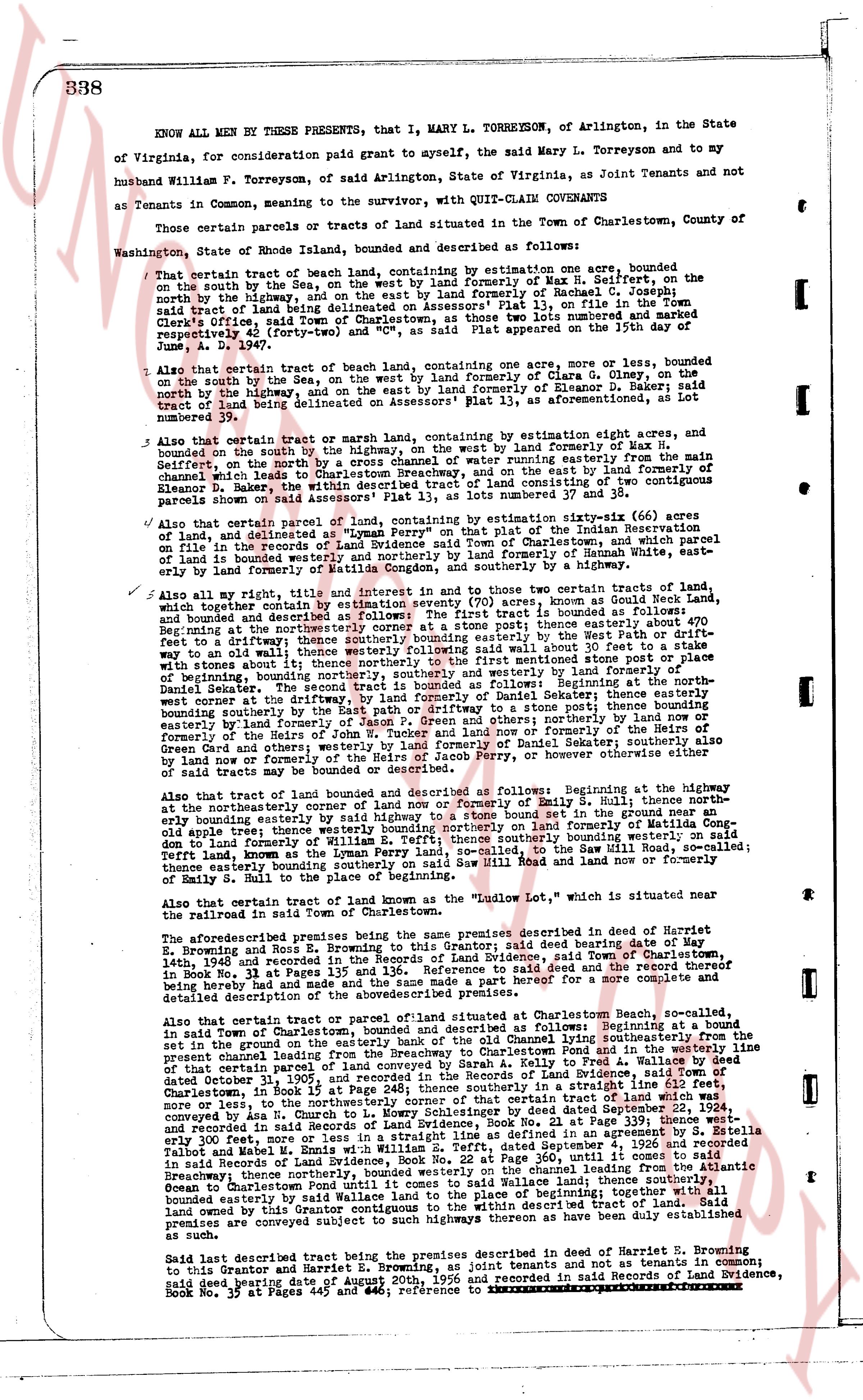
338
KNOW ALL MEN BY THESE PRESENTS, that I, MARY L. TORREYSON, of Arlington, in the State of Virginia, for consideration paid grant to myself, the said Mary L. Torreyson and to my husband William F. Torreyson, of said Arlington, State of Virginia, as Joint Tenants and not as Tenants in Common, meaning to the survivor, with QUIT-CLAIM CONVEYANCE
Those certain parcels or tracts of land situated in the Town of Charlestown, County of Washington, State of Rhode Island, bounded and described as follows:
That certain tract of beach land, containing by estimation one acre, bounded on the south by the Sea, on the east by land formerly of Max S. Gelfert, on the north by the highway, and on the east by land formerly of Rachel C. G. [?] in the Town's tract of land marked as Lot 11, on Assessors' Plat 11, as filed in the Town Clerk's Office, said town of Charlestown, as those two lots numbered and remarked separately in said plat 11, and as appeared on the map dated June 4, 1937.
Also that certain tract of beach land, containing one acre more or less, bounded on the south by the Sea, on the west by land formerly of Clara D. Olney, on the south by bounded on the north by land formerly of Eleanor B. Baker; said tract of land being on the northbound, and on the east as aforementioned, as Lot 3 land being delineated on Assessors' Plat 13, as aforementioned, as Lot 3
Also that certain tract of marsh or trash land, containing by estimation one acre, bounded on the south by the highway, on the south by the highway, on the west by land formerly of Max S. Gelfert, on the north by the highway, and on the east by a stream running easterly from the said Gelfert, on the north by the highway, and on the east by a stream running easterly from the channel which leads to Charlestown Beach, and on the east by land formerly of Eleanor B. Baker; said tract of land being delineated on Assessors' Plat 13, as constitutes of two parcels parcels shown on Assessors' Plat 13, as lots numbered 37 and 38.
Also that certain parcel of land, containing by estimation sixty-six (66) acres of land, and delineated on the map of the town of Charlestown as part of the Indian Reservation file on the Records of Land Evidence said Town of Charlestown, and which parcel of land is bounded on the north by the highway, on the east by land formerly of Hannah White, and on the east by land formerly of Mattias Congdon, and southerly to a highway.
Also all my right, title, and interest in and to those two certain tracts of land, which together contain by estimation seven acres, more or less, known as Buck Head Lake, and bounded and described as follows: The first tract is bounded as follows: Beginning at the northeasterly corner at a stone post; thence easterly by the Way Path or drift-fence to a drift-fence running northerly to a stone post; thence easterly by the Way Path or drift-fence to a wall; thence westerly following said wall about 20 feet to a stone post; thence northerly to a stone post; thence easterly to a bounded stone post or place of origin; beginning, bounding northerly, southerly and westerly by land formerly of Daniel Sekely; thence easterly by the Way Path or drift-fence to a stone post; thence bounding northerly by highway, on the north by land formerly of Daniel Sekely; thence easterly bounded northerly by highway, on the north by a stone wall; thence bounding easterly by land formerly of Jason P. Green and others; northerly land now or formerly of the said Jason P. Green; southerly by land formerly of the said Jason P. Green or Chad Green and others; westerly by land formerly of Daniel Sekely; southerly also by land now or formerly of Daniel Sekely, and others; however others are bounded or said tracts may be bounded or described.
Also that tract of land bounded and described as follows: Beginning at the highway at the northeasterly corner of land now or formerly of Sally S. Ball; thence north easterly bounding easterly by land now or formerly of Sally S. Ball in the ground near an old apple tree; thence westerly bounding easterly on land formerly of Matthew G. [?] to the east formerly of a stone wall; thence northerly bounding westerly on said stone wall to the Lyman Perry land, so called, to the Say Wall Hill Road, so called; thence left turn, land as the Lyman Perry land, so called, to the Say Wall Hill Road, now and formerly the railroad in said Town of Charlestown, and southerly to the edge of the highway and northerly of Sally S. Ball to the place of beginning.
Also that certain tract of land known as the "Ludlow Lot," which is situated near the railroad in the said town of Charlestown.
The aforementioned premises being the same premises described in deed of Harriet E. Browning and Ross E. Browning to this Grantor; said deed bearing date of May 14th, 1948 and recorded in the Records of Land Evidence, said Town of Charlestown, 1948, in Book 30, Page 137 and recorded in the said deed and the record thereof being hereby made and hand and the same made a part hereof for more complete and detailed description.
Also that certain tract or parcel of land situated at Charlestown Beach, so described in said Town of Charlestown, bounded and described as follows: Beginning at a bounded stone post in the ground near the highway, on the north by a stream running easterly from the present channel leading from the Beachway to Charlestown Pond and in the westerly line that runs northerly to the highway, and on the east by land formerly of the said Jason P. Green dated October 11, 1905, and recorded in the Records of Land Evidence, said Town of Charlestown, in a deed dated October 11, 1905, recorded in a deed dated October 11, 1905, and recorded in the Records of Land Evidence, said Town of Charlestown, in a deed dated October 11, 1905, and recorded in the Records of Land Evidence, said Town of Charlestown, in a deed dated October 11, 1905, and recorded in the Records of Land Evidence, said Town of Charlestown, in a deed dated October 11, 1905, and recorded in the Records of Land Evidence, said Town of Charlestown, in a deed dated October 11, 1905, and recorded in the Records of Land Evidence, said Town of Charlestown, in a deed dated October 11, 1905, and recorded in the Records of Land Evidence, said Town of Charlestown, in a deed dated October 11, 1905, and recorded in the Records of Land Evidence, said Town of Charlestown, in a deed dated October 11, 1905, and recorded in the Records of Land Evidence, said Town of Charlestown, in a deed dated October 11, 1905, and recorded in the Records of Land Evidence, said Town of Charlestown, in a deed dated October 11, 1905, and recorded in the Records of Land Evidence, said Town of Charlestown, in a deed dated October 11, 1905, and recorded in the Records of Land Evidence, said Town of Charlestown, in a deed dated October 11, 1905, and recorded in the Records of Land Evidence, said Town of Charlestown, in a deed dated October 11, 1905, and recorded in the Records of Land Evidence, said Town of Charlestown, in a deed dated October 11, 1905, and recorded in the Records of Land Evidence, said Town of Charlestown, in a deed dated October 11, 1905, and recorded in the Records of Land Evidence, said Town of Charlestown, in a deed dated October 11, 1905, and recorded in the Records of Land Evidence, said Town of Charlestown, in a deed dated October 11, 1905, and recorded in the Records of Land Evidence, said Town of Charlestown, in a deed dated October 11, 1905, and recorded in the Records of Land Evidence, said Town of Charlestown, in a deed dated October 11, 1905, and recorded in the Records of Land Evidence, said Town of Charlestown, in a deed dated October 11, 1905, and recorded in the Records of Land Evidence, said Town of Charlestown, in a deed dated October 11, 1905, and recorded in the Records of Land Evidence, said Town of Charlestown, in a deed dated October 11, 1905, and recorded in the Records of Land Evidence, said Town of Charlestown, in a deed dated October 11, 1905, and recorded in the Records of Land Evidence, said Town of Charlestown, in a deed dated October 11, 1905, and recorded in the Records of Land Evidence, said Town of Charlestown, in a deed dated October 11, 1905, and recorded in the Records of Land Evidence, said Town of Charlestown, in a deed dated October 11, 1905, and recorded in the Records of Land Evidence, said Town of Charlestown, in a deed dated October 11, 1905, and recorded in the Records of Land Evidence, said Town of Charlestown, in a deed dated October 11, 1905, and recorded in the Records of Land Evidence, said Town of Charlestown, in a deed dated October 11, 1905, and recorded in the Records of Land Evidence, said Town of Charlestown, in a deed dated October 11, 1905, and recorded in the Records of Land Evidence, said Town of Charlestown, in a deed dated October 11, 1905, and recorded in the Records of Land Evidence, said Town of Charlestown, in a deed dated October 11, 1905, and recorded in the Records of Land Evidence, said Town of Charlestown, in a deed dated October 11, 1905, and recorded in the Records of Land Evidence, said Town of Charlestown, in a deed dated October 11, 1905, and recorded in the Records of Land Evidence, said Town of Charlestown, in a deed dated October 11, 1905, and recorded in the Records of Land Evidence, said Town of Charlestown, in a deed dated October 11, 1905, and recorded in the Records of Land Evidence, said Town of Charlestown, in a deed dated October 11, 1905, and recorded in the Records of Land Evidence, said Town of Charlestown, in a deed dated October 11, 1905, and recorded in the Records of Land Evidence, said Town of Charlestown, in a deed dated October 11, 1905, and recorded in the Records of Land Evidence, said Town of Charlestown, in a deed dated October 11, 1905, and recorded in the Records of Land Evidence, said Town of Charlestown, in a deed dated October 11, 1905, and recorded in the Records of Land Evidence, said Town of Charlestown, in a deed dated October 11, 1905, and recorded in the Records of Land Evidence, said Town of Charlestown, in a deed dated October 11, 1905, and recorded in the Records of Land Evidence, said Town of Charlestown, in a deed dated October 11, 1905, and recorded in the Records of Land Evidence, said Town of Charlestown, in a deed dated October 11, 1905, and recorded in the Records of Land Evidence, said Town of Charlestown, in a deed dated October 11, 1905, and recorded in the Records of Land Evidence, said Town of Charlestown, in a deed dated October 11, 1905, and recorded in the Records of Land Evidence, said Town of Charlestown, in a deed dated October 11, 1905, and recorded in the Records of Land Evidence, said Town of Charlestown, in a deed dated October 11, 1905, and recorded in the Records of Land Evidence, said Town of Charlestown, in a deed dated October 11, 1905, and recorded in the Records of Land Evidence, said Town of Charlestown, in a deed dated October 11, 1905, and recorded in the Records of Land Evidence, said Town of Charlestown, in a deed dated October 11, 1905, and recorded in the Records of Land Evidence, said Town of Charlestown, in a deed dated October 11, 1905, and recorded in the Records of Land Evidence, said Town of Charlestown, in a deed dated October 11, 1905, and recorded in the Records of Land Evidence, said Town of Charlestown, in a deed dated October 11, 1905, and recorded in the Records of Land Evidence, said Town of Charlestown, in a deed dated October 11, 1905, and recorded in the Records of Land Evidence, said Town of Charlestown, in a deed dated
page 2 · read by Gemma vision
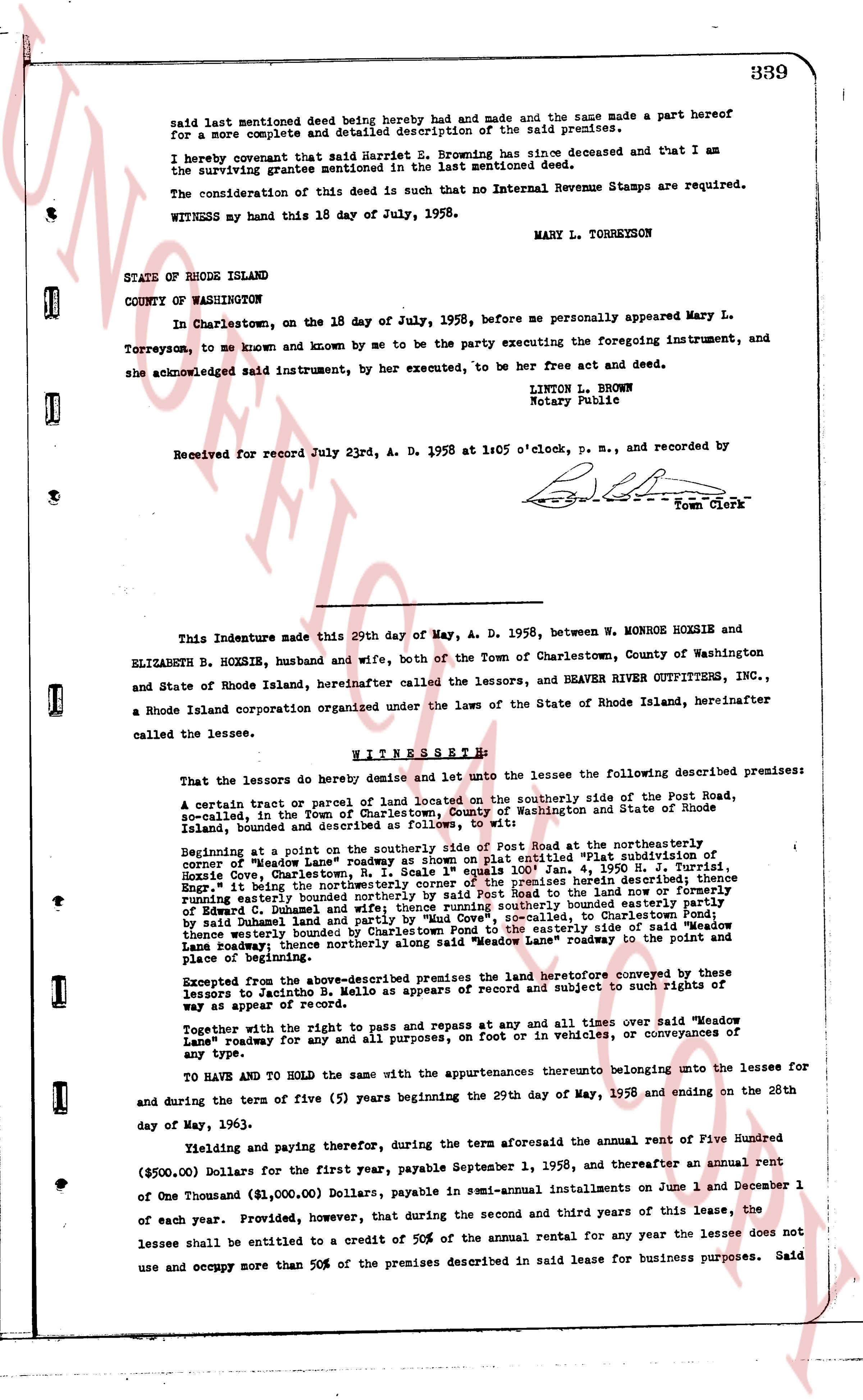
339
Said last mentioned deed being hereby had and made and the same made a part hereof for a more complete and detailed description of the said premises.
I hereby covenant that said Harriet E. Browning has since deceased and that I am the surviving grantee mentioned in the last mentioned deed.
The consideration of this deed is such that no Internal Revenue Stamps are required.
WITNESS my hand this 18 day of July, 1958. MARY L. TORREYSON
STATE OF RHODE ISLAND
COUNTY OF WASHINGTON
In Charlestown, on the 18 day of July, 1958, before me personally appeared Mary L. Torreyson, to me known and known by me to be the party executing the foregoing instrument, and she acknowledged said instrument, by her executed, to be her free act and deed.
LINTON L. BROWN
Notary Public
Received for Record July 23rd, A. D. 1958 at 1:05 o'clock, p. m., and recorded by
[Signature]
Town Clerk
----
This Indenture made this 29th day of May, A. D. 1958, between W. MONROE HOXSIE and ELIZABETH B. HOXSIE, husband and wife, both of the Town of Charlestown, County of Washington and State of Rhode Island aforesaid, hereinafter called the lessors, and BEAVER RIVER OUTFITTERS, INC., a Rhode Island corporation organized under the laws of the State of Rhode Island aforesaid, hereinafter called the lessee.
WITNESSETH,
That the lessors do hereby demise and let unto the lessee the following described premises:
A certain tract or parcel of land located on the southerly side of the Post Road, so-called, in the Town of Charlestown, County of Washington and State of Rhode Island, bounded and described as follows:
Beginning at a point on the southerly side of Post Road at the northeasterly corner of "Meadow Lane" Post Roadway as shown on plat entitled "Plat subdivision of Corner of Meadow Lane Post Roadway" as shown on plat entitled "Plat subdivision of Corner of Meadow Lane Post Roadway" as shown on plat entitled "Plat subdivision of Corner of Meadow Lane Post Roadway" as shown on plat entitled "Plat subdivision of Corner of Meadow Lane Post Roadway" as shown on plat entitled "Plat subdivision of Corner of Meadow Lane Post Roadway" as shown on plat entitled "Plat subdivision of Corner of Meadow Lane Post Roadway" as shown on plat entitled "Plat subdivision of Corner of Meadow Lane Post Roadway" as shown on plat entitled "Plat subdivision of Corner of Meadow Lane Post Roadway" as shown on plat entitled "Plat subdivision of Corner of Meadow Lane Post Roadway" as shown on plat entitled "Plat subdivision of Corner of Meadow Lane Post Roadway" as shown on plat entitled "Plat subdivision of Corner of Meadow Lane Post Roadway" as shown on plat entitled "Plat subdivision of Corner of Meadow Lane Post Roadway" as shown on plat entitled "Plat subdivision of Corner of Meadow Lane Post Roadway" as shown on plat entitled "Plat subdivision of Corner of Meadow Lane Post Roadway" as shown on plat entitled "Plat subdivision of Corner of Meadow Lane Post Roadway" as shown on plat entitled "Plat subdivision of Corner of Meadow Lane Post Roadway" as shown on plat entitled "Plat subdivision of Corner of Meadow Lane Post Roadway" as shown on plat entitled "Plat subdivision of Corner of Meadow Lane Post Roadway" as shown on plat entitled "Plat subdivision of Corner of Meadow Lane Post Roadway" as shown on plat entitled "Plat subdivision of Corner of Meadow Lane Post Roadway" as shown on plat entitled "Plat subdivision of Corner of Meadow Lane Post Roadway" as shown on plat entitled "Plat subdivision of Corner of Meadow Lane Post Roadway" as shown on plat entitled "Plat subdivision of Corner of Meadow Lane Post Roadway" as shown on plat entitled "Plat subdivision of Corner of Meadow Lane Post Roadway" as shown on plat entitled "Plat subdivision of Corner of Meadow Lane Post Roadway" as shown on plat entitled "Plat subdivision of Corner of Meadow Lane Post Roadway" as shown on plat entitled "Plat subdivision of Corner of Meadow Lane Post Roadway" as shown on plat entitled "Plat subdivision of Corner of Meadow Lane Post Roadway" as shown on plat entitled "Plat subdivision of Corner of Meadow Lane Post Roadway" as shown on plat entitled "Plat subdivision of Corner of Meadow Lane Post Roadway" as shown on plat entitled "Plat subdivision of Corner of Meadow Lane Post Roadway" as shown on plat entitled "Plat subdivision of Corner of Meadow Lane Post Roadway" as shown on plat entitled "Plat subdivision of Corner of Meadow Lane Post Roadway" as shown on plat entitled "Plat subdivision of Corner of Meadow Lane Post Roadway" as shown on plat entitled "Plat subdivision of Corner of Meadow Lane Post Roadway" as shown on plat entitled "Plat subdivision of Corner of Meadow Lane Post Roadway" as shown on plat entitled "Plat subdivision of Corner of Meadow Lane Post Roadway" as shown on plat entitled "Plat subdivision of Corner of Meadow Lane Post Roadway" as shown on plat entitled "Plat subdivision of Corner of Meadow Lane Post Roadway" as shown on plat entitled "Plat subdivision of Corner of Meadow Lane Post Roadway" as shown on plat entitled "Plat subdivision of Corner of Meadow Lane Post Roadway" as shown on plat entitled "Plat subdivision of Corner of Meadow Lane Post Roadway" as shown on plat entitled "Plat subdivision of Corner of Meadow Lane Post Roadway" as shown on plat entitled "Plat subdivision of Corner of Meadow Lane Post Roadway" as shown on plat entitled "Plat subdivision of Corner of Meadow Lane Post Roadway" as shown on plat entitled "Plat subdivision of Corner of Meadow Lane Post Roadway" as shown on plat entitled "Plat subdivision of Corner of Meadow Lane Post Roadway" as shown on plat entitled "Plat subdivision of Corner of Meadow Lane Post Roadway" as shown on plat entitled "Plat subdivision of Corner of Meadow Lane Post Roadway" as shown on plat entitled "Plat subdivision of Corner of Meadow Lane Post Roadway" as shown on plat entitled "Plat subdivision of Corner of Meadow Lane Post Roadway" as shown on plat entitled "Plat subdivision of Corner of Meadow Lane Post Roadway" as shown on plat entitled "Plat subdivision of Corner of Meadow Lane Post Roadway" as shown on plat entitled "Plat subdivision of Corner of Meadow Lane Post Roadway" as shown on plat entitled "Plat subdivision of Corner of Meadow Lane Post Roadway" as shown on plat entitled "Plat subdivision of Corner of Meadow Lane Post Roadway" as shown on plat entitled "Plat subdivision of Corner of Meadow Lane Post Roadway" as shown on plat entitled "Plat subdivision of Corner of Meadow Lane Post Roadway" as shown on plat entitled "Plat subdivision of Corner of Meadow Lane Post Roadway" as shown on plat entitled "Plat subdivision of Corner of Meadow Lane Post Roadway" as shown on plat entitled "Plat subdivision of Corner of Meadow Lane Post Roadway" as shown on plat entitled "Plat subdivision of Corner of Meadow Lane Post Roadway" as shown on plat entitled "Plat subdivision of Corner of Meadow Lane Post Roadway" as shown on plat entitled "Plat subdivision of Corner of Meadow Lane Post Roadway" as shown on plat entitled "Plat subdivision of Corner of Meadow Lane Post Roadway" as shown on plat entitled "Plat subdivision of Corner of Meadow Lane Post Roadway" as shown on plat entitled "Plat subdivision of Corner of Meadow Lane Post Roadway" as shown on plat entitled "Plat subdivision of Corner of Meadow Lane Post Roadway" as shown on plat entitled "Plat subdivision of Corner of Meadow Lane Post Roadway" as shown on plat entitled "Plat subdivision of Corner of Meadow Lane Post Roadway" as shown on plat entitled "Plat subdivision of Corner of Meadow Lane Post Roadway" as shown on plat entitled "Plat subdivision of Corner of Meadow Lane Post Roadway" as shown on plat entitled "Plat subdivision of Corner of Meadow Lane Post Roadway" as shown on plat entitled "Plat subdivision of Corner of Meadow Lane Post Roadway" as shown on plat entitled "Plat subdivision of Corner of Meadow Lane Post Roadway" as shown on plat entitled "Plat subdivision of Corner of Meadow Lane Post Roadway" as shown on plat entitled "Plat subdivision of Corner of Meadow Lane Post Roadway" as shown on plat entitled "Plat subdivision of Corner of Meadow Lane Post Roadway" as shown on plat entitled "Plat subdivision of Corner of Meadow Lane Post Roadway" as shown on plat entitled "Plat subdivision of Corner of Meadow Lane Post Roadway" as shown on plat entitled "Plat subdivision of Corner of Meadow Lane Post Roadway" as shown on plat entitled "Plat subdivision of Corner of Meadow Lane Post Roadway" as shown on plat entitled "Plat subdivision of Corner of Meadow Lane Post Roadway" as shown on plat entitled "Plat subdivision of Corner of Meadow Lane Post Roadway" as shown on plat entitled "Plat subdivision of Corner of Meadow Lane Post Roadway" as shown on plat entitled "Plat subdivision of Corner of Meadow Lane Post Roadway" as shown on plat entitled "Plat subdivision of Corner of Meadow Lane Post Roadway" as shown on plat entitled "Plat subdivision of Corner of Meadow Lane Post Roadway" as shown on plat entitled "Plat subdivision of Corner of Meadow Lane Post Roadway" as shown on plat entitled "Plat subdivision of Corner of Meadow Lane Post Roadway" as shown on plat entitled "Plat subdivision of Corner of Meadow Lane Post Roadway" as shown on plat entitled "Plat subdivision of Corner of Meadow Lane Post Roadway" as shown on plat entitled "Plat subdivision of Corner of Meadow Lane Post Roadway" as shown on plat entitled "Plat subdivision of Corner of Meadow Lane Post Roadway" as shown on plat entitled "Plat subdivision of Corner of Meadow Lane Post Roadway" as shown on plat entitled "Plat subdivision of Corner of Meadow Lane Post Roadway" as shown on plat entitled "Plat subdivision of Corner of Meadow Lane Post Roadway" as shown on plat entitled "Plat subdivision of Corner of Meadow Lane Post Roadway" as shown on plat entitled "Plat subdivision of Corner of Meadow Lane Post Roadway" as shown on plat entitled "Plat subdivision of Corner of Meadow Lane Post Roadway" as shown on plat entitled "Plat subdivision of Corner of Meadow Lane Post Roadway" as shown on plat entitled "Plat subdivision of Corner of Meadow Lane Post Roadway" as shown on plat entitled "Plat subdivision of Corner of Meadow Lane Post Roadway" as shown on plat entitled "Plat subdivision of Corner of Meadow Lane Post Roadway" as shown on plat entitled "Plat subdivision of Corner of Meadow Lane Post Roadway" as shown on plat entitled "Plat subdivision of Corner of Meadow Lane Post Roadway" as shown on plat entitled "Plat subdivision of Corner of Meadow Lane Post Roadway" as shown on plat entitled "Plat subdivision of Corner of Meadow Lane Post Roadway" as shown on plat entitled "Plat subdivision of Corner of Meadow Lane Post Roadway" as shown on plat entitled "Plat subdivision of Corner of Meadow Lane Post Roadway" as shown on plat entitled "Plat subdivision of Corner of Meadow Lane Post Roadway" as shown on plat entitled "Plat subdivision of Corner of Meadow Lane Post Roadway" as shown on plat entitled "Plat subdivision of Corner of Meadow Lane Post Roadway" as shown on plat entitled "Plat subdivision of Corner of Meadow Lane Post Roadway" as shown on plat entitled "Plat subdivision of Corner of Meadow Lane Post Roadway" as shown on plat entitled "Plat subdivision of Corner of Meadow Lane Post Roadway" as shown on plat entitled "Plat subdivision of Corner of Meadow Lane Post Roadway" as shown on plat entitled "Plat subdivision of Corner of Meadow Lane Post Roadway" as shown on plat entitled "Plat subdivision of Corner of Meadow Lane Post Roadway" as shown on plat entitled "Plat subdivision of Corner of Meadow Lane Post Roadway" as shown on plat entitled "Plat subdivision of Corner of Meadow Lane Post Roadway" as shown on plat entitled "Plat subdivision of Corner of Meadow Lane Post Roadway" as shown on plat entitled "Plat subdivision of Corner of Meadow Lane Post Roadway" as shown on plat entitled "Plat subdivision of Corner of Meadow Lane Post Roadway" as shown on plat entitled "Plat subdivision of Corner of Meadow Lane Post Roadway" as shown on plat entitled "Plat subdivision of Corner of Meadow Lane Post Roadway" as shown on plat entitled "Plat subdivision of Corner of Meadow Lane Post Roadway" as shown on plat entitled "Plat subdivision of Corner of Meadow Lane Post Roadway" as shown on plat entitled "Plat subdivision of Corner of Meadow Lane Post Roadway" as shown on plat entitled "Plat subdivision of Corner of Meadow Lane Post Roadway" as shown on plat entitled "Plat subdivision of Corner of Meadow Lane Post Roadway" as shown on plat entitled "Plat subdivision of Corner of Meadow Lane Post Roadway" as shown on plat entitled "Plat subdivision of Corner of Meadow Lane Post Roadway" as shown on plat entitled "Plat subdivision of Corner of Meadow Lane Post Roadway" as shown on plat entitled "Plat subdivision of Corner of Meadow Lane Post Roadway" as shown on plat entitled "Plat subdivision of Corner of Meadow Lane Post Roadway" as shown on plat entitled "Plat subdivision of Corner of Meadow Lane Post Roadway" as shown on plat entitled "Plat subdivision of Corner of Meadow Lane Post Roadway" as shown on plat entitled "Plat subdivision of Corner of Meadow Lane Post Roadway" as shown on plat entitled "Plat subdivision of Corner of Meadow Lane Post Roadway" as shown on plat entitled "Plat subdivision of Corner of Meadow Lane Post Roadway" as shown on plat entitled "Plat subdivision of Corner of Meadow Lane Post Roadway" as shown on plat entitled "Plat subdivision of Corner
The page as recorded