The instrument's own words
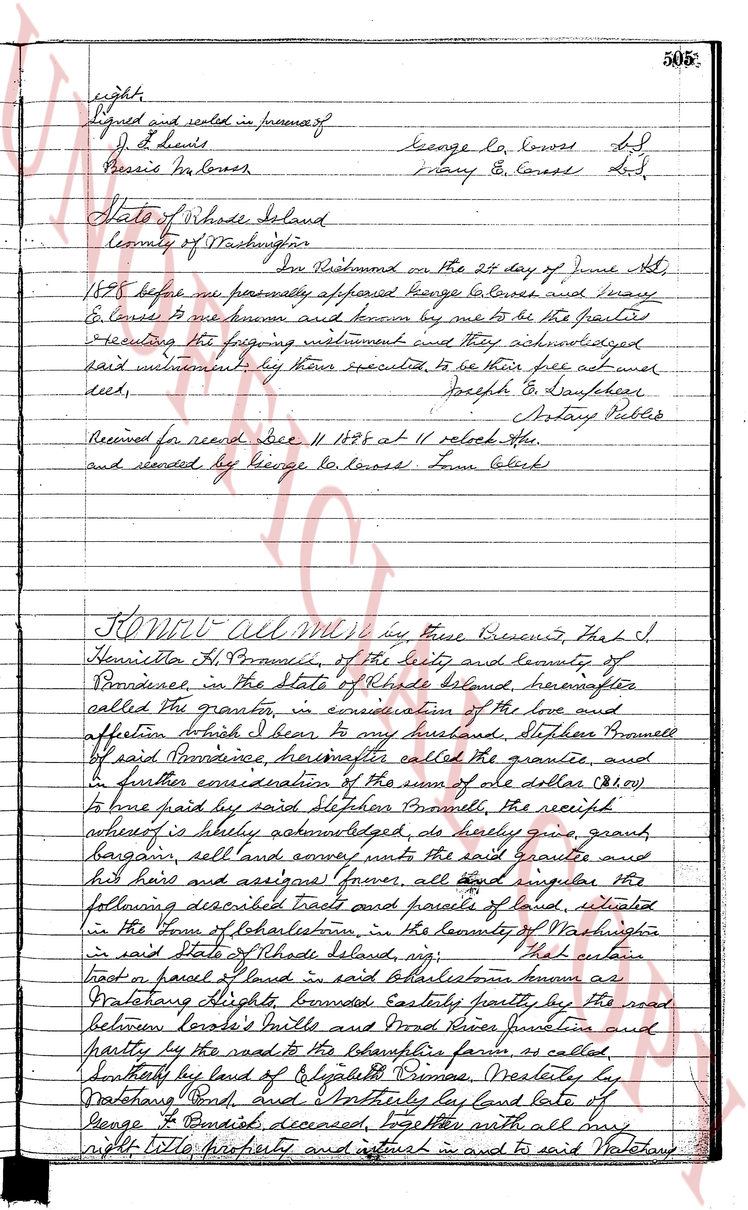
page 1
505*
rights
Signed and sealed in presence of
J. S. Lewis
Pressis Ha Lowess
George La Lowess L.S.
Mary E. Lowess L.S.
State of Rhode Island
County of Washington
In Providence on the 21 day of June A.D.
1884 before me personally appeared George G. Lowess and Mary
E. Lowess to me known and known by me to be the parties
executing the foregoing instrument and they acknowledged
said instrument, by their executed, to be their free act and
deed,
Joseph G. Danforth
Notary Public
Received for record Dec. 11 1884 at 11 oclock A.M.
and recorded by George G. Lowess Town Clerk
KNOW All Men by these Presents, That I
Henrietta H. Brunell, Branch, of the City and County of
Providence, in the State of Rhode Island, hereinafter
called the grantor, in consideration of the love and
affection to which I bear to my husband, Stephen Brunell
of said Providence hereinafter called the grantee, and
in further consideration of the sum of one dollar ($1.00)
to be paid by said Stephen Brunell, the receipt
whereof is hereby acknowledged, do hereby give, grant,
bargain, sell and convey unto the said grantee and
his heirs and assigns forever, all land singular the
following described tracts and parcels of land, situated
in the Town of Charlestown, in the County of Washington
in said State of Rhode Island, viz:
That certain
tract or parcel of land in said Charlestown known as
Waterstone Heights bounded Easterly partly by the road
between Lowess's Mills and Wood River junction and
partly by the road to the Chapman farm, as called
Southerly by land of Elizabeth Primes, Westerly by
Waterstone Pond, and Northerly by land late of
George F. Benedict, deceased, together with all my
rights Title property and interest in and to said Waterstone
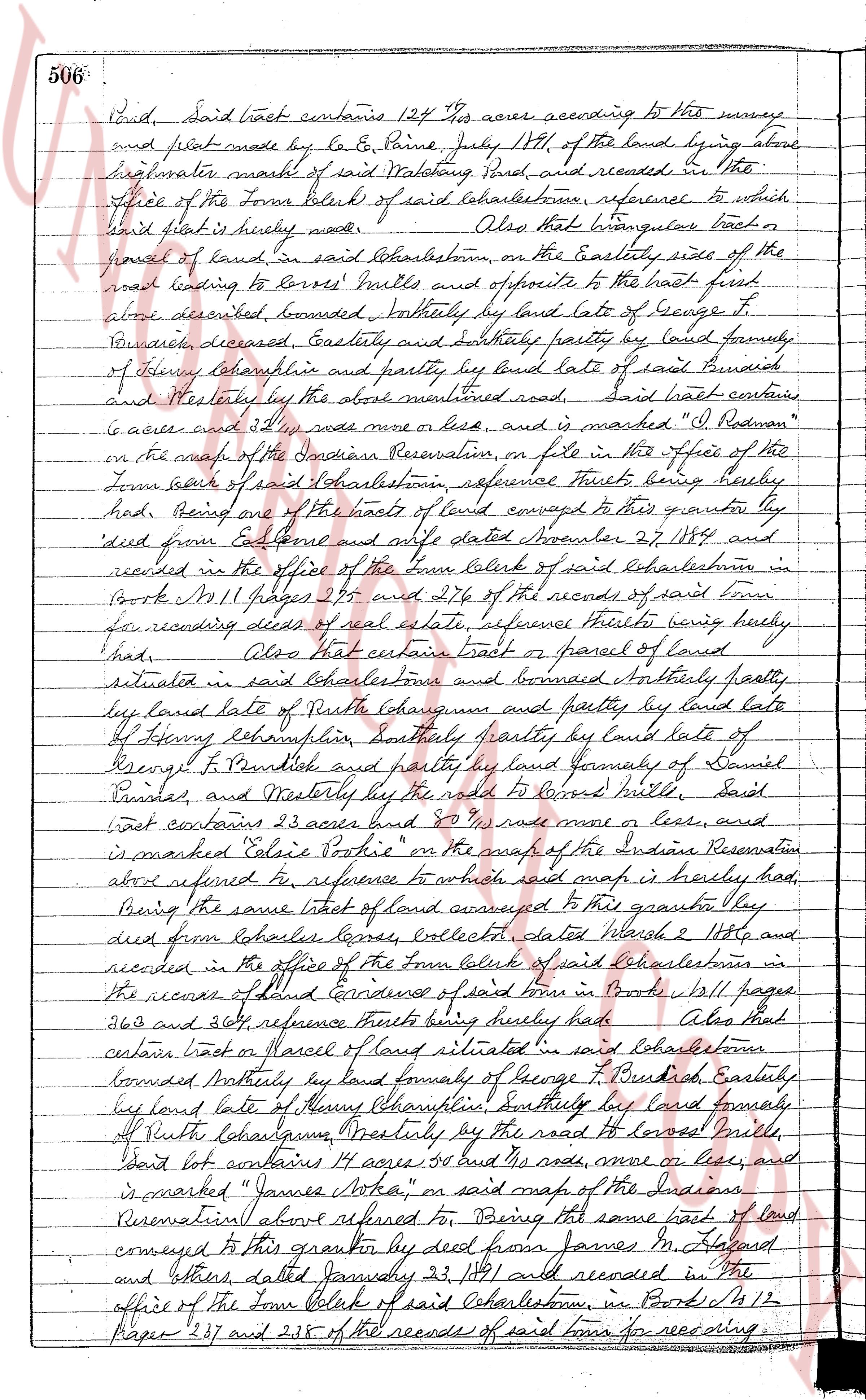
page 2
506. Land, Said tract contains 124 1/2 acres according to the survey
and plat made by C. E. Paine, July 17th, 17th of the land lying above
high water mark of said Watchung Pond, and recorded in the
Office of the Town Clerk of said Charlestown, reference to which
said plat is hereby made. Also that triangular tract or
parcel of land in said Charlestown, on the Easterly side of the
road leading to Dover's Mills and opposite to the tract first
above described, bounded Northerly by land late of George T.
Butterfield, deceased, Easterly and Southerly partly by land formerly
of Henry Champlain and partly by land late of said Butterfield
and Westerly by the above mentioned road, said tract contains
6 acres and 34 1/2 rods more or less, and is marked "I. Rodman"
on the map of the Indian Reservation, on file in the Office of the
Town Clerk of said Charlestown reference thereto being hereby
made, Being one of the tracts of land conveyed to this grantor by
deed from Eze. Colman and his wife dated November 27, 1784 and
recorded in the office of the Town Clerk of said Charlestown in
Books M. 11 Pages 275 and 276 of the records of said town for
recording deeds of real estate, reference thereto being hereby
made. Also that certain tract or parcel of land
situated in said Charlestown and bounded Northerly partly
by land late of Ruth Lohman and partly by land late
of Henry Champlain, Southerly partly by land late of
Henry F. Butterfield and partly by land formerly of Daniel
Prattas, and Westerly by the road to Dover's Mills, said
tract contains 23 acres and 80 rods more or less, and
is marked "Eliza Potter" on the map of the Indian
Reservation above referred to, reference to which said map is hereby made
Being the same tract of land conveyed to this grantor by
deed from Josiah Loney, Collector dated March 2 1792 and
recorded in the office of the Town Clerk of said Charlestown in
the records of land Evidence of said town in Books 11 Pages
363 and 364, reference thereto being hereby made. Also that
certain tract or parcel of land situated in said Charlestown
bounded Northerly by land formerly of George T. Butterfield, Easterly
by land late of Henry Champlain, Southerly by land formerly
of Ruth Lohman, Westerly by the road to Dover's Mills,
said tract contains 14 acres 80 rods more or less, and
is marked "James Potter" on said map of the Indian
Reservation above referred to, Being the same tract of land
conveyed to this grantor by deed from James M. Potter
and others, dated January 23, 1811 and recorded in the
office of the Town Clerk of said Charlestown in Book M 12
Pages 237 and 238 of the records of said town for recording
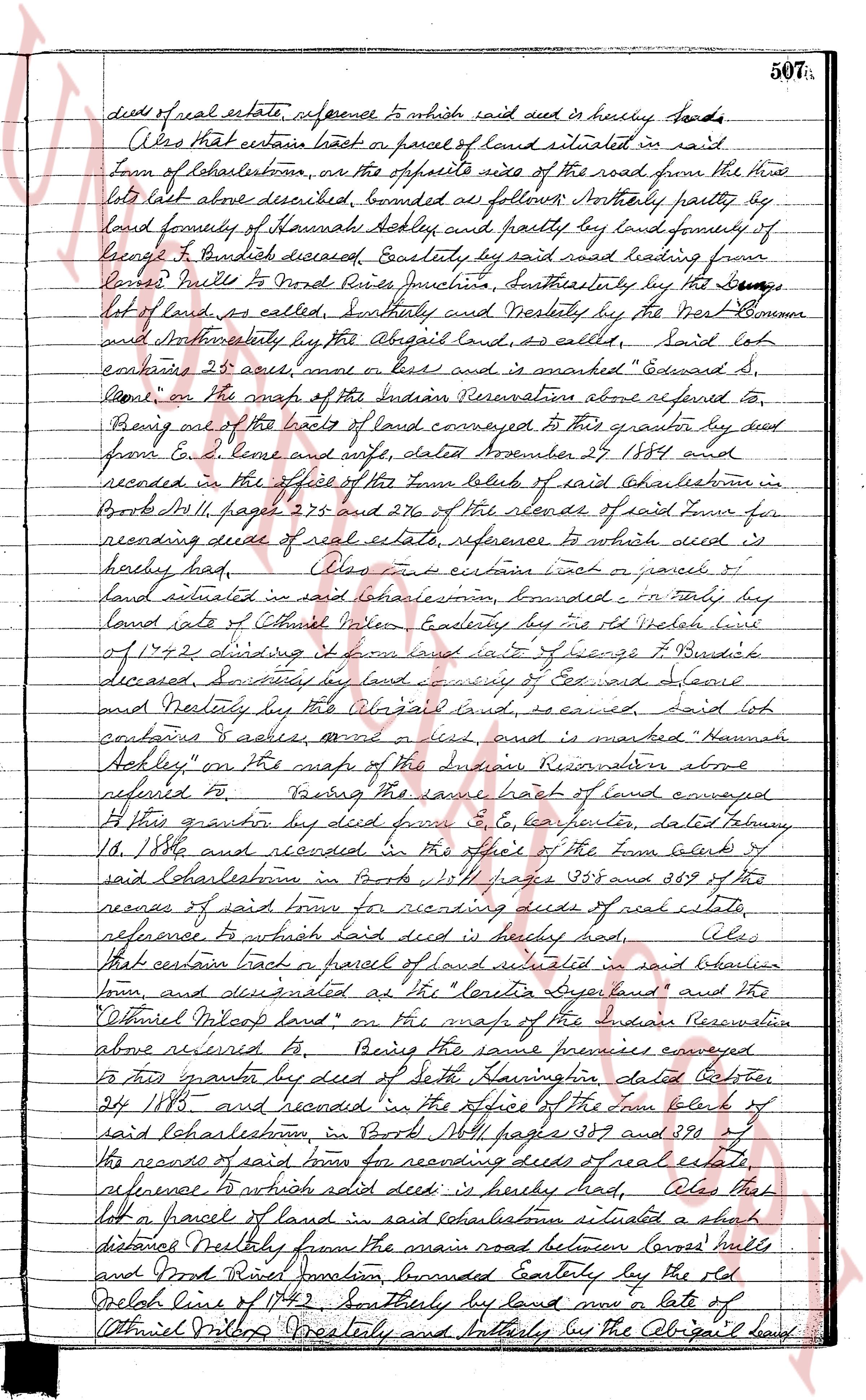
page 3
deed of real estate, reference to which said deed is hereby had.
Also that certain tract or parcel of land situated in said
town of Charlestown, on the opposite side of the road from the three
lots last above described, bounded as follows: Northerly partly by
land formerly of Hannah Ashley and partly by land formerly of
George P. Burdick deceased Easterly by said road leading from
Canes Neck to Wood River Junction, Northerly by the [illegible]
lot of land, as called, Southerly and Westerly by the West Common
and Northwesterly by the Abigail land, as called, Said lot
contains 25 acres more or less and is marked "Edward S.
Paine" on the map of the Indian Reservation above referred to,
Being one of the tracts of land conveyed to this grantor by deed
from E. S. Paine and wife, dated December 27, 1874 and
recorded in the office of the town clerk of said Charlestown in
Book M, 11, page 275 and 276 of the records of said town for
recording deeds of real estate, reference to which said deed is
hereby had. Also that certain tract or parcel of
land situated in said Charlestown, bounded: On Easterly by
land late of Ethel Wilson Easterly by the old Peckham line
of 1742 dividing it from land late of George P. Burdick
deceased, Southerly by land now of Cox and Alvord
and Westerly by the Abigail land and is marked "Hannah
Ashley" on the map of the Indian Reservation above
referred to, Being the same tract of land conveyed
to this grantor by deed from E. S. Paine, dated February
18, 1880 and recorded in the office of the town clerk of
said Charlestown in Book M, 11, pages 285 and 286 of the
records of said town for recording deeds of real estate,
reference to which said deed is hereby had. Also
that certain tract or parcel of land situated in said Indian
town, and designated as the "Penelope land" and the
"Ethel Milcop land" on the map of the Indian Reservation
above referred to, Being the same premises conveyed
to this grantor by deed of Seth Lawton, dated October
24 1883 and recorded in the office of the town clerk of
said Charlestown in Book M, 11, pages 389 and 390 of
the records of said town for recording deeds of real estate,
reference to which said deed is hereby had. Also that
lot or parcel of land in said Charlestown situated a short
distance Northly from the main road between Canes Neck
and Wood River Junction, bounded Easterly by the old
Peckham line of 1742 Southerly by land now late of
Ethel Milcop Westerly and Northerly by the Abigail land
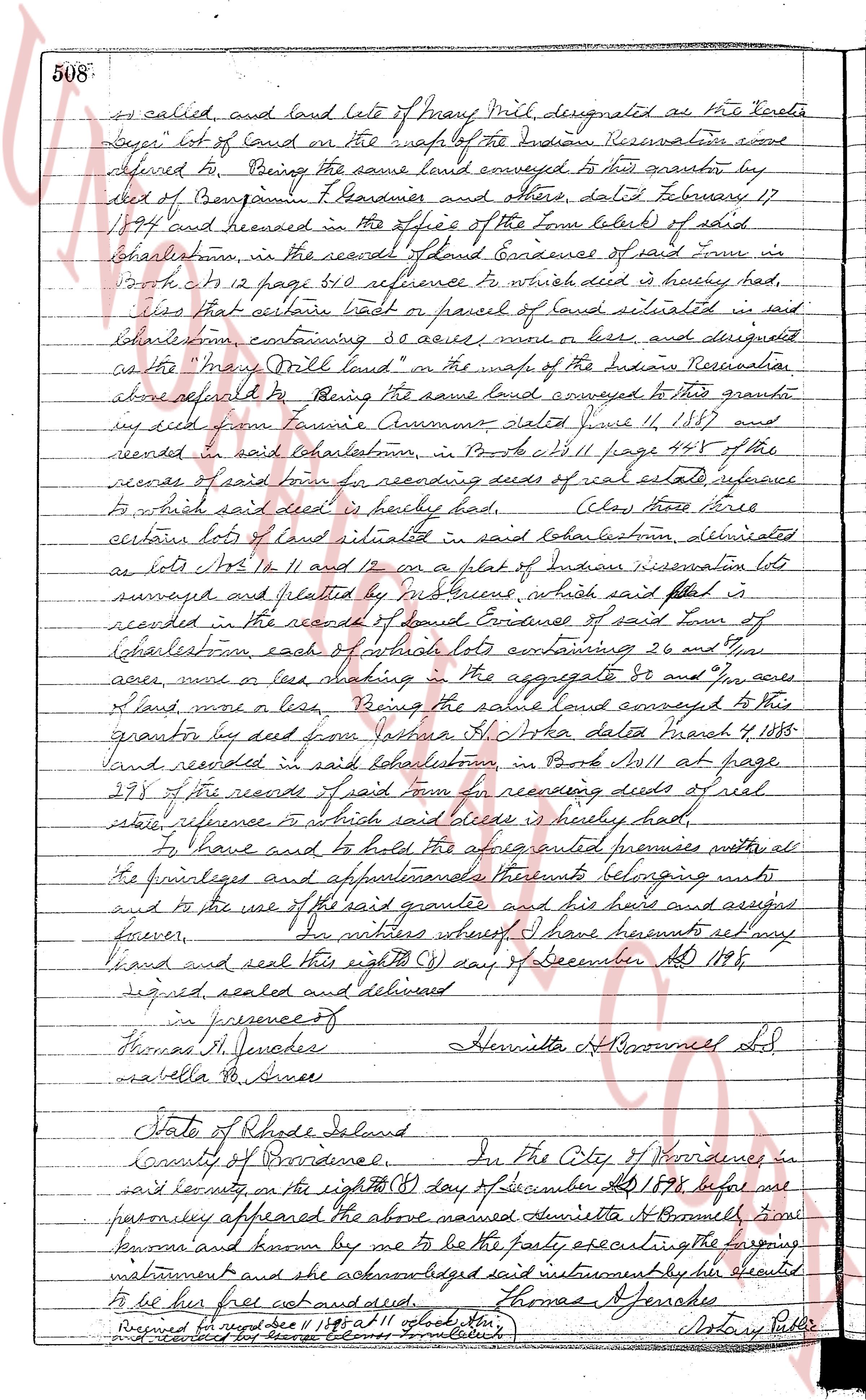
page 4
508.
as called and land lote of Many Mill designated as the First
Buyer lot of land on the map of the Indian Reservation and
referred to Being the same land conveyed to this grantor by
deed of Benjamin T. Gardner and others dated February 17
1894 and recorded in the office of the Town Clerk of said
Charlestown in the records of Land Evidence of said town in
Book 42 page 61 reference to which deed is hereby had,
also that certain lot or parcel of land situated in said
Charlestown containing 80 acres more or less and designated
as the "Many Mill land" on the map of the Indian Reservation
afore referred to Being the same land conveyed to this grantor
by deed from Fannie Assummo dated June 11, 1887 and
recorded in said Charlestown in Book 41 page 498 of the
records of said town for recording deeds of real estate reference
to which said deed is hereby had, also those three
certain lots of land situated in said Charlestown designated
as lots No 10, 11 and 12 on a plat of Indian reservation lots
surveyed and platted by influence which said plat is
recorded in the records of Land Evidence of said town of
Charlestown each of actually lots containing 26 and 2/10
acres more or less making in the aggregate 80 and 6/10
acres more or less Being the same land conveyed to this
grantor by deed from Johanna A. Doka dated March 4, 1885
and recorded in said Charlestown in Book 41 page
278 of the records of said town for recording deeds of real
estate reference to which said deed is hereby had
To have and to hold the above described premises with all
the fixtures and appurtenances thereunto belonging unto
and to the use of the said grantee and his heirs and assigns
forever In witness whereof I have hereunto set my
hand and seal this eighth (8) day of December AD 1898
signed sealed and delivered
in presence of
Thomas J. Fernandes
Isabella R. Anne
Henrietta A Brownell L.D.
State of Rhode Island
County of Providence In the City of Providence in
said county on the eighth (8) day of December AD 1898 before me
personally appeared the above named Henrietta A Brownell from
whom and known by me to be the party executing the foregoing
instrument and she acknowledged said instrument by her sealed
to be her free act and deed.
Thomas J. Fernandes
Received and recorded Dec 11 1897 at 11 o'clock’ Notary Public
and recorded for record fee two dollars’ [illegible] [illegible]
The page as recorded