The instrument's own words
page 1 · read by Gemma vision
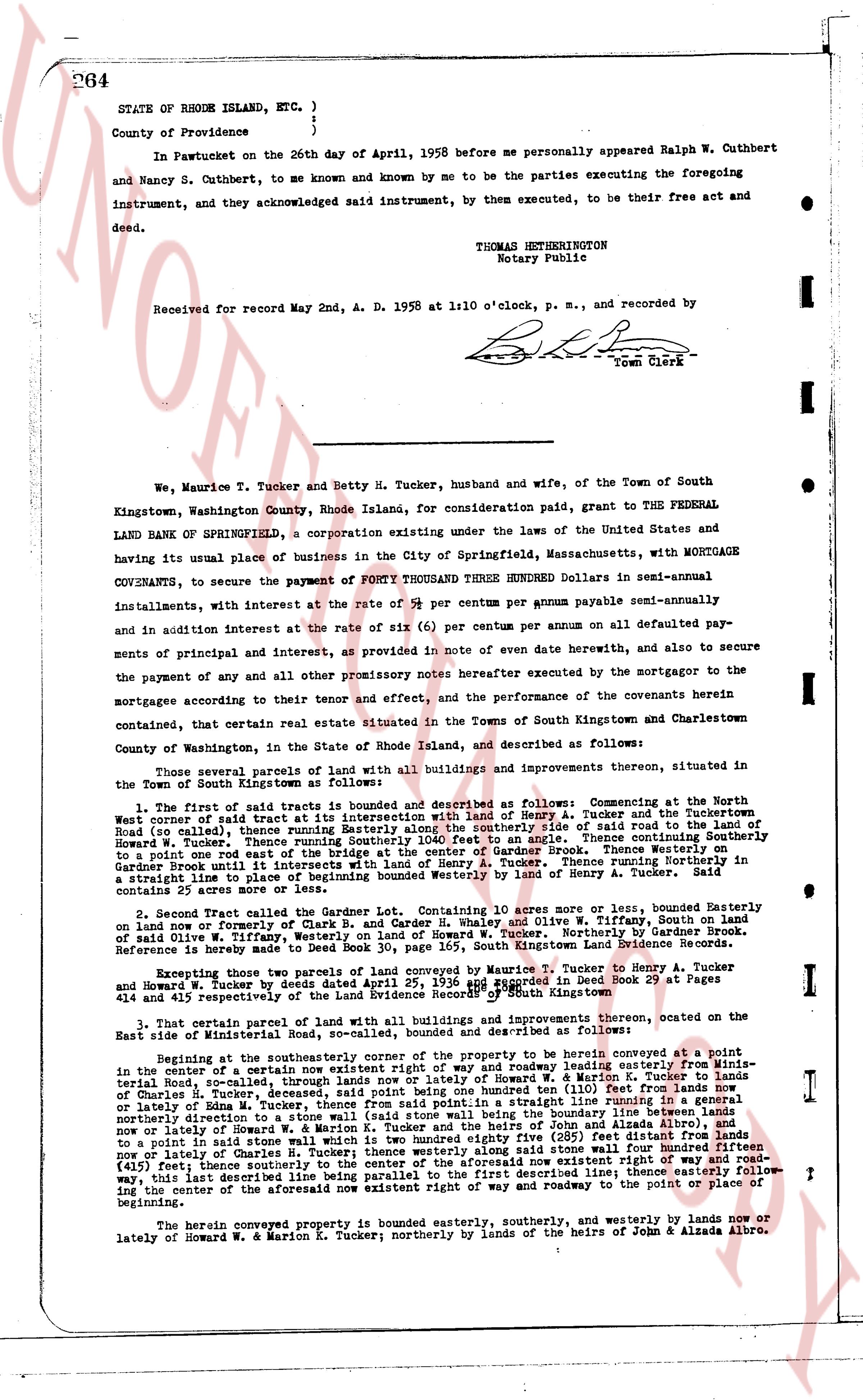
264
STATE OF RHODE ISLAND, ETC.)
)
County of Providence )
In Pawtucket on the 26th day of April, 1958 before me personally appeared Ralph W. Cuthbert and Nancy S. Cuthbert, to me known and known by me to be the parties executing the foregoing instrument, and they acknowledged said instrument, by them executed, to be their free act and deed.
THOMAS HETHERINGTON
Notary Public
Received for record May 2nd, A. D. 1958 at 1:10 o'clock, p. m., and recorded by
[Signature]
Town Clerk
We, Maurice T. Tucker and Betty H. Tucker, husband and wife, of the Town of South Kingstown, Washington County, Rhode Island, for consideration paid, grant to THE FEDERAL LAND BANK OF SPRINGFIELD, a corporation existing under the laws of the United States and having its usual place of business in the City of Springfield, Massachusetts, with MORTGAGE COVENANTS, to secure the payment of FORTY THOUSAND THREE HUNDRED Dollars in semi-annual installments, with interest at the rate of 5 per centum payable semi-annually and in addition interest at the rate of six (6 per centum per annum on all defaulted payments of principal and interest, as provided in note of even date hereinafter written, and also to secure the payment of any and all other promissory notes hereafter executed by the mortgagor to the mortgagee according to their tenor and effect, and the performance of the covenants herein contained, that certain real estate situated in the Towns of South Kingstown and Charlestown County of Washington, in the State of Rhode Island, and described as follows:
Those several parcels of land with all buildings and improvements thereon, situated in the Town of South Kingstown as follows:
1. The first of said tracts is bounded and described as follows: Commencing at the North West corner of said tract at the intersection with the southerly line of Henry A. Tucker and the Tuckerton Road (so called), thence running Easterly along the southerly line of said road to an angle, Thence continuing Southerly to a point one rod east the bridge at the center of the Garden Brook. Thence Westerly on Garden Brook until it intersects the southerly line of Henry A. Tucker. Thence running Northerly in a straight line to place of beginning bounded Westerly by land of Henry A. Tucker. Said contains 25 acres more or less.
2. Second Tract called the Garden Lot. Containing 10 acres more or less, bounded Easterly on land of [?] or formerly of Clark B. and Garden H. Whaley and Olive W. Whaley, bounded South on olive S. Oliff W. Tiffany, northwesternly on land of [?] Northwesterly by Garden Brook. Reference made save as recorded Deed Book 30, page 165, South Kingstown Land Evidence Books.
Excepting those two parcels of land conveyed by Maurice T. Tucker to Henry A. Tucker and Howard W. Tucker by deed dated April 25, 1936 and recorded in Deed Book 29 at Pages 414 and 415 respectively of the Land Evidence Records of South Kingstown.
3. That certain parcel with all land of the buildings and improvements thereon, coated on the East side of Ministerial Road, so called, bounded and described as follows:
Beginning at the southeasterly corner of the property to be herein conveyed at a point in the center of a certain road, then running Easterly along said road extending from Ministerial Road, southwesterly, through lands now or lately of Howard W. & Marion K. Tucker to lands of Charles H. Tucker, deceased, said point being at the intersection of the southerly line of Charles H. Tucker, deceased, and the center of said road; and a point in a straight line running in a general northerly direction to a stone wall (said stone wall being the boundary line between the lands of Ezra Rome, † deceased, and the lands of [?] of John & Alzada Albro), and thence northerly to a point in said stone wall which is two hundred eighty five (285) feet all line of lands now or lately of Howard W. & Marion K. Tucker, thence running East in said stone wall four hundred fifteen (415) feet; thence southerly to the center of the aforesaid now existent right of way and roadway, and thence running Westerly along the center of said right of way and roadway to the point of following the center of the aforesaid now existent right of way and roadway to the point of place of beginning.
The herein conveyed property is bounded easterly, southerly, and westerly by lands now or lately of Howard W. & Marion K. Tucker; northerly by lands of the heirs of John & Alzada Albro.
page 2 · read by Gemma vision
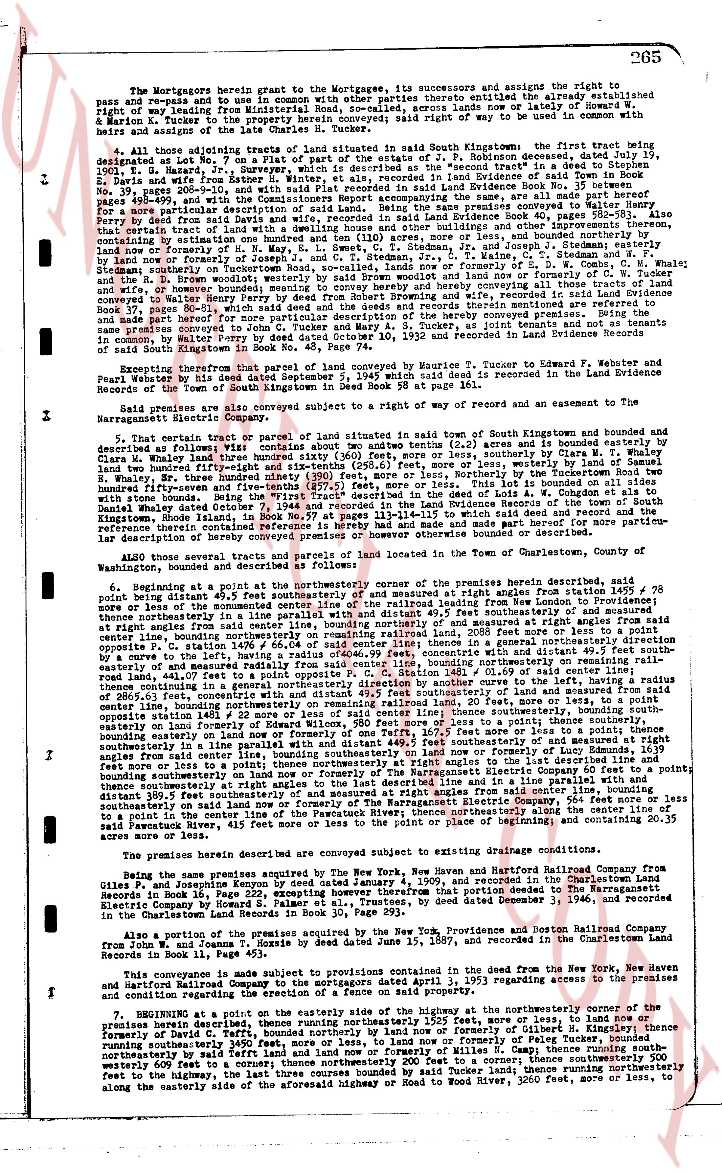
265
The Mortgagors herein grant to the Mortgagee, its successors and assigns the right to pass and ride and to use in common with other users thereto entitled the already established right of way leading from Winterfield Road, so-called, across lands now or lately owned by Howard W. & Marion K. Tucker to the property herein conveyed; said right of way to be used in common with heirs to the above named.
4. All those adjoining tracts of land situated in said South Kingstown: the first tract being designated as Lot No. 7 on a plat of the estate of the P. R. Robinson deceased, dating 11/15/1936, and marked "A" on said plat, conveyed to Maurice T. Tucker and Betty H. Tucker from Stephen E. Davis & wife from Esther H. Winter, at once, recorded in Land Evidence of said town in Book 36, page 209-210, with said wife and from Esther H. Winter, at once, recorded in Land Evidence Book 36, page 210-211; the second tract being the remainder of said Lot No. 7, being approximately the same acreage, all land made part of the above described, recorded in Land Evidence Book 40, pages 582-583. Also that certain tract of land with a dwelling house and other buildings and other improvements situated in Charlestown, Rhode Island, in the neighborhood of the road leading from the center of town northerly by the land now or formerly of E. N. May, L. E. Swett, C. T. Stedman, and J. P. Stedman; easterly marked by the land now or formerly of D. W. Combs, C. M. Whale, and others; southerly on Tuckerton Road, so-called, lands now or formerly of D. W. Combs, C. M. Whale; and westerly by the land now or formerly of Maurice T. Tucker and Betty H. Tucker, husband and wife, other westward boundary; said mortgagor to convey hereby and reserve hereby all those tracts of land conveyed to them by a deed from the heirs of the estate of the P. R. Robinson deceased, recorded in Land Evidence Book 37, pages 80-81, which said deed and the deeds and records therein mentioned are referred to and made part hereof; said tract of land being conveyed to Maurice T. Tucker and Betty H. Tucker, husband and wife, by a deed from the heirs of the estate of the P. R. Robinson deceased, recorded in Land Evidence Book 37, page 80, conveyed to John C. Tucker and Mary A. B. Tucker, as joint tenants and not as tenants in common, by walter Porry by deed dated October 10, 1942 and recorded in Land Evidence of said town in Book 38, page 311.
Excepting however that parcel of land conveyed by Maurice T. Tucker to Edward F. Webster and Pearl Webster by deeds dated September 5, 1945 which said deed is recorded in the Land Evidence Records of the Town of Charlestown in Book 38 at page 313.
Said premises are also conveyed subject to an easement of road and easement to the Narragansett Electric Company.
5. That certain tract or parcel of land situated in said town of Kingstown and bounded easterly and dexterly as follows: the tract contains about two and two tenths acres (2.2) and is bounded easterly by Clara M. Whale land hundred thirty six (336) feet, more or less, southerly by Clara M. W. Whale land two hundred ninety five (295) feet, more or less, westerly by the Tuckerton Road one hundred ninety three (193) feet, more or less, northerly by the Tuckerton Road one hundred fifty-five (155) feet and (47) feet, more or less, and then by the land of the Narragansett Electric Company one hundred fifty-five (155) feet, more or less, as described in the deed of Lois A. W. Coddington as et al to Winfield and Bonnie Coddington by deed dated June 1, 1944 and recorded in Land Evidence Book 34, page 111-114-20 and said deed which and made part hereof for more particular description of said other buildings or improvements on said property.
Also those several tracts and parcels of land located in the Town of Charlestown, County of Washington, bounded and described as follows:
Beginning at point at the northwesterly corner of the premises herein described; said point being distant 4.1 feet west of the center line of the road measured at right angles from station 1495 +/- 78 points more or less of the southernmost center line of the railroad leading from New London to Providence; thence northerly on said center line, bounding northerly on said railroad, 110 feet, more or less, and then 110 feet, more or less, from said center line, bounding northerly of and measured at right angles from said center line, bounding northerly on the southernmost center line of said center line; thence in a generally northeasterly direction intersecting the C. O. Station siding at right angles from said center line, bounding northerly on said siding, by a curve to the left, having a radius of 2046.99 feet, an arc of 116.01 feet, bounding northerly on remaining rail road land, 441.07 feet to a point opposite F. C. Company Station 142 +/- 0.1 feet of the southernmost center line of the railroad leading from New London to Providence; thence in a generally northeasterly direction to the left, having a radius of 2865.63 feet, concentric with and distant 49.5 feet southeasterly of the land managed and used by the New York, New Haven and Hartford Railroad Company, an arc of 111.11 feet, to a point opposite station 148 +/- 22 more or less of said center line; thence southeasterly, bounding southeasterly on the railroad leading from New London to Providence, 110 feet, more or less, to a point opposite station 148 +/- 22 more or less of said center line; thence southeasterly, bounding easterly on land now or formerly own of Tefft, 165.7 feet more or less to a point; thence southeasterly, bounding easterly on land now or formerly of Lucy E. Edmunds, 163.9 feet more or less to a point; thence southeasterly, bounding easterly on land now or formerly of Lucy E. Edmunds, 163.9 feet more or less to a point; thence southeasterly, bounding easterly on land now or formerly of Lucy E. Edmunds, 163.9 feet more or less to a point; thence southeasterly, bounding southerly on land now or formerly of Lucy E. Edmunds, 163.9 feet more or less to a point; thence southeasterly, bounding southeasterly on land now or formerly of the Narragansett Electric Company 60 feet to a point; thence southeasterly at right angles to the center line of the road, 110 feet, more or less, to a point; thence southeasterly, bounding southeasterly on said road, measured at right angles from said center line, bounding southeasterly on said road, 110 feet, more or less, to a point; thence southeasterly, bounding northerly along the center line or less to said Pawcatuck River, 415 feet more or less to the point of its center, and bounding of containing: 23.05 acres more or less.
The premises herein described are conveyed subject to existing drainage conditions.
Said premises are being assumed the properties acquired by the New York, New Haven and Hartford Railroad Company from Giles P. Osborne and Jameson key by deed dated January 4, 1909, and recorded in the Charlestown Land Evidence Records Book 13, page 111; and acquired from the estate of Daniel G. Moore by deed dated December 8, 1909, recorded in Charlestown Land Records in Book 13, page 294; and acquired from the estate of Howard P. Palmer by S. E. trust, alternatives, et al, by deed dated December 3, 1946, and recorded in the Charlestown Land Records in Book 30, Page 293.
Also a portion of the premises are acquired by the New York, Providence and Boston Railroad Company from the estate of Sarah Palmer by deed dated December 15, 1857, and recorded in the Charlestown Land Records in Book 11, Page 453.
This conveyance is made subject to provisions contained in the deed from the New York, New Haven and Hartford Railroad Company to the mortgagors dated April 3, 1953 regarding access to the premises and condition regarding the erection of a fence on said property.
7. BEGINNING at a point on the easterly side of the highway at the northeasterly corner of the premises, more or less, to land now or formerly of David C. Tefft, bounded northerly by land now or formerly of Gilbert H. Kingsley; thence easterly, bounding northerly by said land now or formerly of Gilbert H. Kingsley; thence running southeasterly by said Tefft land and land now or formerly of Milles H. Camp; thence running southeasterly by said Tefft land and land now or formerly of Maurice T. Tucker; thence running southeasterly 600 feet to a corner; thence northwesterly, bounding northerly by land now or formerly of David C. Tefft, 600 feet to a corner; thence running northwesterly by said Tucker land; thence running northwesterly 3260 feet to a corner; thence running northwesterly by said River Road, 3260 feet, more or less, to and along the easterly side of the aforesaid highway or Road to Home.
page 3 · read by Gemma vision
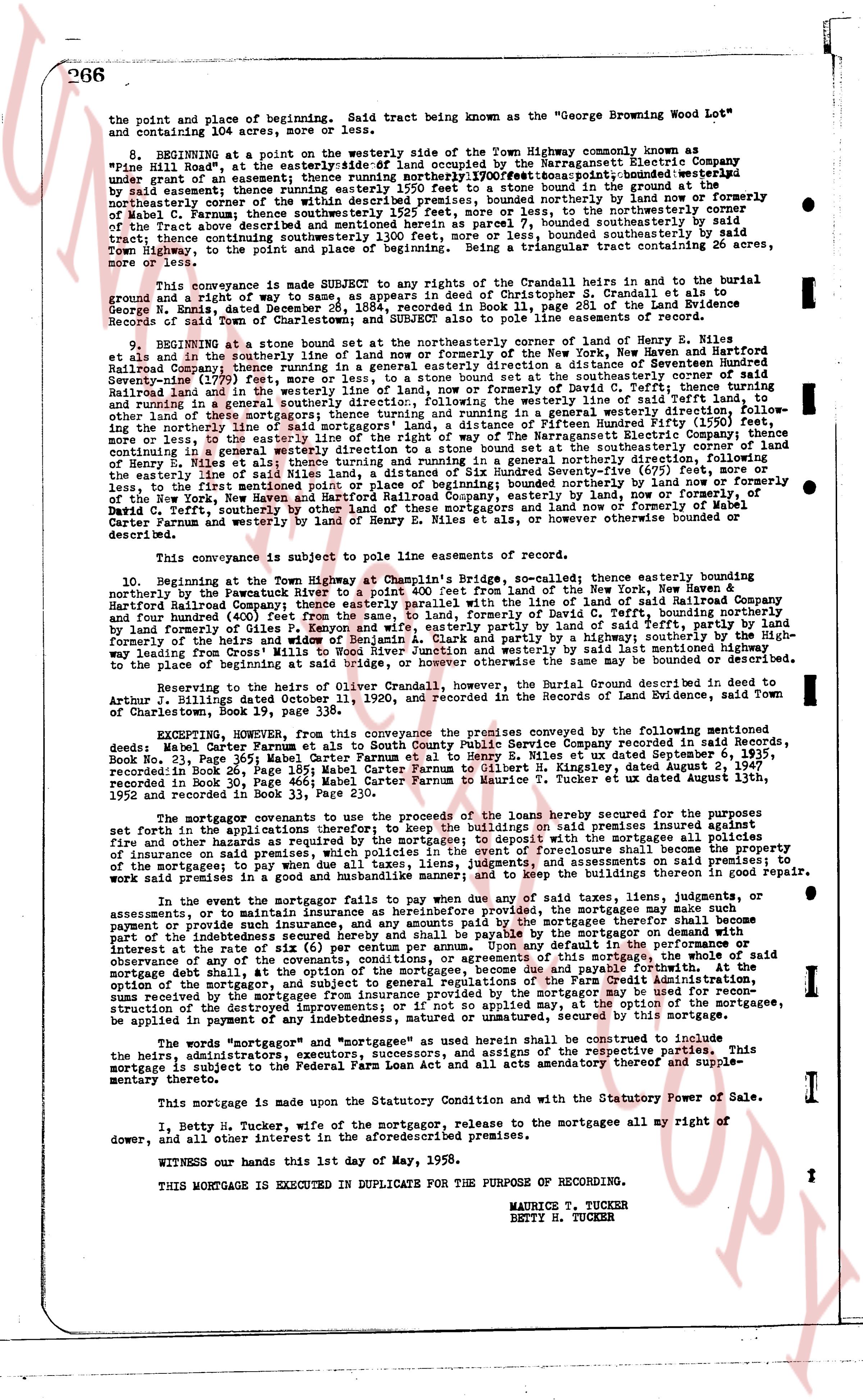
the point and place of beginning. Said tract being known as the "George Browning Wood Lot"
and containing 104 acres, more or less.
----
8. BEGINNING at a point on the easterly side of the Town Highway commonly known as
"Pine Hill Road", at the easterlyside of the land occupied by the Narragansett Electric Company
and north of the right of way of the New York, New Haven and Hartford Railway, bounded westerly
by said easement; thence running easterly 1550 feet, more or less to a stone bound in the ground at
the southeasterly corner of the land of Maurice T. Tucker, bounded easterly by land of formerly
of Mabel F. Turner; thence southeasterly 1525 feet, more or less, to the northeasterly corner wer
of the Tract above described and southeasterly corner of the land of Maurice T. Tucker, bounded
southeasterly by land of Maurice T. Tucker; thence westerly 1300 feet, more or less, bounded southeasterly
by said Town Highway, to the point and place of beginning. Being a triangular tract comprising 26 acres,
more or less.
This conveyance is subject to MADE SUBJECT to any rights of the Crandall heirs in and to a burial
ground and a right of way as same appears in deed of Christopher J. Crandall et al to George
George, dated December 1, 1853 and recorded in book 234 page 283 of the land evidence
Records of said Town of CHARLESTOWN and subject to pole line easements of record.
BEGINNING at a stone bound set at the northeasterly corner of land of Henry E. Niles
at the easterly side of the right of way of the New York, New Haven and Hartford Railway, New Haven
Railroad and Railway, thence running in a general easterly direction a distance of Seventeen Hundred
Seventeen (1717) feet, more or less, to a stone bound in the ground at the northeasterly corner of said
Railroad land and in the westerly line of land of, now or formerly of David C. Tefft, thence turning
and running in a general southerly direction a distance of Three Hundred Twenty (320) feet, more or
less, to a stone bound in the ground; thence turning and running in a general westerly direction, follow-
ing the northerly line of said mortgagors' land, a distance of One Thousand Hundred Twenty (1120)
feet, more or less, to a stone bound in the ground at the northeasterly corner of the Narragansett Electric
Company and continuing in a general westerly direction to a stone bound set at the southeasterly corner
of land of Henry E. Niles, then running in a general northerly direction, following the easterly line
of the easterly line of said Niles land, a distance of Six Hundred Twenty-five (625) feet, more or
less, to the point of beginning. Being a tract of land bounded on the north by land of now or formerly
of the New York, New Haven and Hartford Railroad Company, easterly land of, now or formerly, of
Seth S. and Sarah A. Tefft, southerly by land of now or formerly of the Narragansett Electric Company,
Carter Farnum and westerly by land of Henry E. Niles et al., otherwise or however bounded otherwise
or described.
This conveyance is subject to pole line easements of record.
10. beginning at the Town Highway at Champlain's Bridge, south-east; thence easterly bounding
northerly by the Pawcatuck River to a point 400 feet (from land of the New York, New Haven
Railroad and Railway) thence running in a general southerly direction to the land of Narragansett Electric
Company and further (400) feet to the southeasterly corner of the land of, now or formerly, of David Tefft,
bounded easterly by land of formerly of Giles P. Kenyon and wife, easterly partly by land of said
formerly of David Tefft, thence running in a general westerly direction, southerly by the High-
way leading from Cross Hill's Mill to Wood River Junction and westerly by said last mentioned highway
to the place of beginning. Being a tract of land comprising 34 acres, more or less.
Referring to the deeds of Oliver Crandall, however, the Burial Ground described in deed to
Arthur J. Billings dated October 11, 1920, and recorded in the Records of Land Evidence, said Town
of Charlestown, Book 201 Page 134.
EXCEPTING, HOWEVER, from this conveyance the premises conveyed by the following mentioned
deeds: Mabel Carter Farnum et als to South County Public Service Company recorded in said Records,
Book No. 221, Page 384; Mabel Carter Farnum et als to South County Public Service Company recorded
in said Records Book No. 264 Page 185; Mabel Carter Farnum to Oliver H. Kingsley, dated August 2, 1947
recorded in Book No. 304, Page 460; Mabel Carter Farnum to Maurice T. Tucker et ux dated August 13th,
1952 and recorded in Book No. 333 Page 111.
The mortgagor covenants to use the proceeds of the loans hereby secured for the purposes
set forth in the applications therefore; to keep the buildings on said premises insured against fire
and other hazards as may be required by the mortgagee, and to maintain in force all policies
of insurance on said premises, which policies in the event of foreclosure shall become the property of
the mortgagee and in priority to any other person or persons; and to keep the premises and to
work said premises in a good and husbandlike manner; and to keep the buildings thereon in good repair.
In the event the mortgagor fails to pay when due any of said taxes, liens, judgments, or
assessments, or to maintain said insurance, the mortgagee may pay the same and the amount of such
payment or provide such insurance, and any amounts paid by the mortgagor therefore shall become
a sum due immediately to the mortgagee and shall be added to the mortgage money without
interest (except in the case of 6% per centum) per annum. Upon any default in the performance or
observance of any of the covenants, conditions, or agreements herein, the entire sum of the mortgage
money shall at the option of the mortgagee, become due and payable forthwith. At the
option of the mortgagee, and subject to general regulations of the Federal Land Bank, any sum so
recovered by the mortgagee in the event of a default of the mortgagor may be used for re-
construction of the destroyed improvements or if not so applied may, at the option of the mortgagee,
be applied in payment of any sum due and unpaid secured by the mortgage.
The words "mortgagor" and "mortgagee" as used herein shall be construed to include
the heirs, administrators, executors, successors, and assigns of the respective parties. This
mortgage is Subject to the Federal Land Bank Loan act and all acts amendatory thereof and supple-
mentary thereto.
This mortgage is made upon the Statutory Condition and with the Statutory Power of Sale.
I, Betty H. Tucker, wife of the mortgagor, release to the mortgagor, all my right of
dower, and all other interest in the aforementioned premises.
WITNESS our hands this 1st day of May, 1958.
THIS MORTGAGE IS EXECUTED IN DUPLICATE FOR THE PURPOSE OF RECORDING.
MAURICE T. TUCKER
BETTY H. TUCKER
page 4 · read by Gemma vision
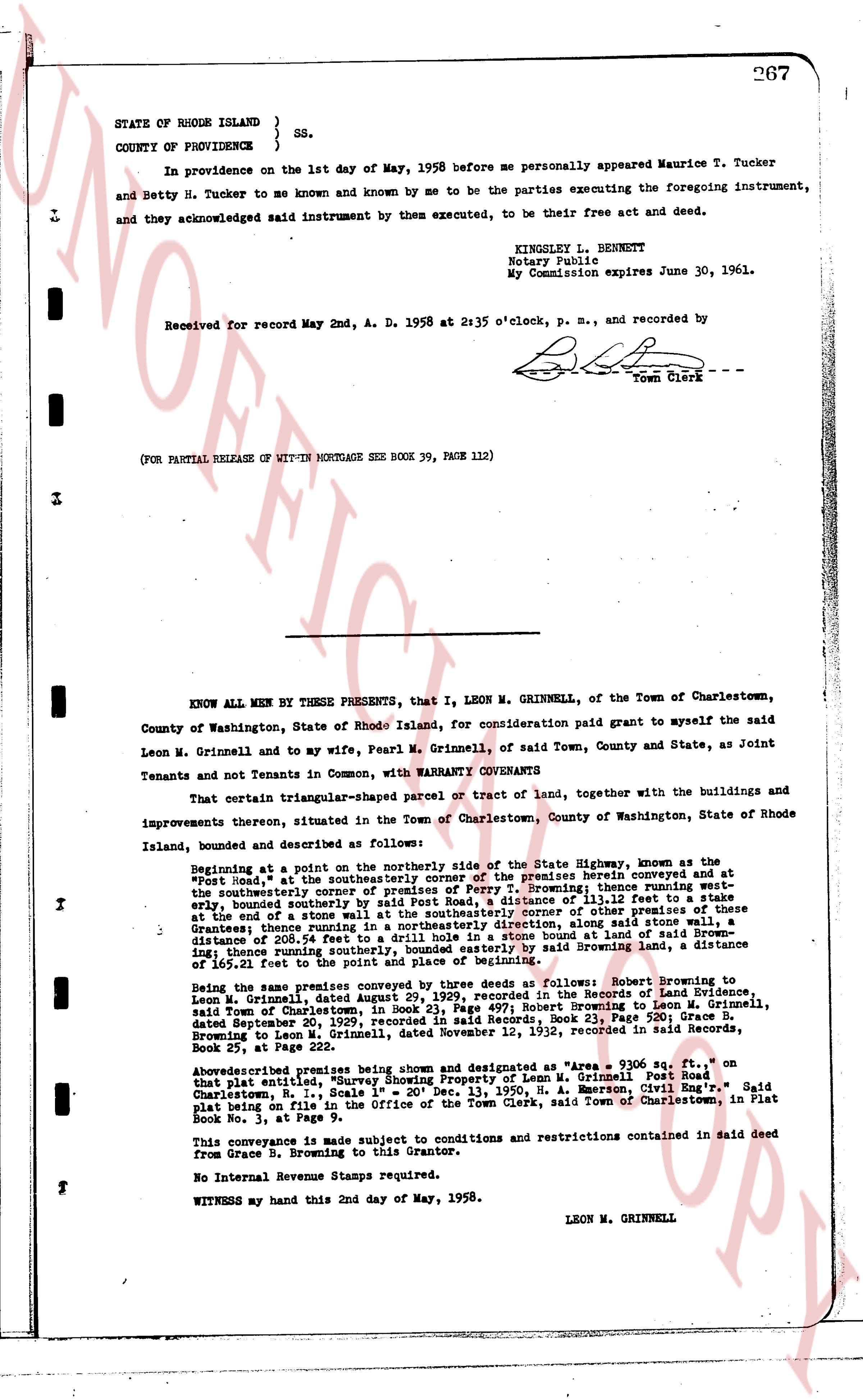
267
STATE OF RHODE ISLAND }
} SS.
COUNTY OF PROVIDENCE {
In presence of on the 1st day of May, 1958 before me personally appeared Maurice T. Tucker and Betty H. Tucker to me known and known by me to be the parties executing the foregoing instrument, and they acknowledged said instrument by them executed, to be their free act and deed.
KINGSLEY L. BENNETT
Notary Public
My Commission expires June 30, 1961.
Received for record May 2nd, A. D. 1958 at 2:35 o'clock, p. m., and recorded by
[Signature]
Town Clerk
(FOR PARTIAL RELEASE OF MORTGAGE SEE BOOK 39, PAGE 112)
----
KNOW ALL MEN BY THESE PRESENTS that I, LEON M. GRINNELL, of the Town of Charlestown, County of Washington, State of Rhode Island, for consideration paid grant to myself the said Leon M. Grinnell and to my wife, Pearl M. Grinnell, of said Town, County and State, as Joint Tenants and not Tenants in Common, with WARRANTY COVENANTS
That certain triangular-shaped parcel or tract of land, together with the buildings and improvements thereon, situated in the Town of Charlestown, County of Washington, State of Rhode Island, bounded and described as follows:
Beginning at a point on the northerly side of the State Highway, known as the "Post Road," at the southeasterly corner of the premises hereof conveyed and at the southeasterly corner of the land of Robert Browning; thence running west-at the southeasterly boundary by said Post Road, a distance of 11.12 ft to a stake at the end of the boundary by said Post Road, a distance of 11.12 ft to a stake at the end of the boundary by said Post Road, a distance of 11.12 ft to a stake at the end of the boundary by said Post Road, a distance of 11.12 ft to a stake at the end of the boundary by said Post Road, a distance of 11.12 ft to a stake at the end of the boundary by said Post Road, a distance of 11.12 ft to a stake at the end of the boundary by said Post Road, a distance of 11.12 ft to a stake at the end of the boundary by said Post Road, a distance of 11.12 ft to a stake at the end of the boundary by said Post Road, a distance of 11.12 ft to a stake at the end of the boundary by said Post Road, a distance of 11.12 ft to a stake at the end of the boundary by said Post Road, a distance of 11.12 ft to a stake at the end of the boundary by said Post Road, a distance of 11.12 ft to a stake at the end of the boundary by said Post Road, a distance of 11.12 ft to a stake at the end of the boundary by said Post Road, a distance of 11.12 ft to a stake at the end of the boundary by said Post Road, a distance of 11.12 ft to a stake at the end of the boundary by said Post Road, a distance of 11.12 ft to a stake at the end of the boundary by said Post Road, a distance of 11.12 ft to a stake at the end of the boundary by said Post Road, a distance of 11.12 ft to a stake at the end of the boundary by said Post Road, a distance of 11.12 ft to a stake at the end of the boundary by said Post Road, a distance of 11.12 ft to a stake at the end of the boundary by said Post Road, a distance of 11.12 ft to a stake at the end of the boundary by said Post Road, a distance of 11.12 ft to a stake at the end of the boundary by said Post Road, a distance of 11.12 ft to a stake at the end of the boundary by said Post Road, a distance of 11.12 ft to a stake at the end of the boundary by said Post Road, a distance of 11.12 ft to a stake at the end of the boundary by said Post Road, a distance of 11.12 ft to a stake at the end of the boundary by said Post Road, a distance of 11.12 ft to a stake at the end of the boundary by said Post Road, a distance of 11.12 ft to a stake at the end of the boundary by said Post Road, a distance of 11.12 ft to a stake at the end of the boundary by said Post Road, a distance of 11.12 ft to a stake at the end of the boundary by said Post Road, a distance of 11.12 ft to a stake at the end of the boundary by said Post Road, a distance of 11.12 ft to a stake at the end of the boundary by said Post Road, a distance of 11.12 ft to a stake at the end of the boundary by said Post Road, a distance of 11.12 ft to a stake at the end of the boundary by said Post Road, a distance of 11.12 ft to a stake at the end of the boundary by said Post Road, a distance of 11.12 ft to a stake at the end of the boundary by said Post Road, a distance of 11.12 ft to a stake at the end of the boundary by said Post Road, a distance of 11.12 ft to a stake at the end of the boundary by said Post Road, a distance of 11.12 ft to a stake at the end of the boundary by said Post Road, a distance of 11.12 ft to a stake at the end of the boundary by said Post Road, a distance of 11.12 ft to a stake at the end of the boundary by said Post Road, a distance of 11.12 ft to a stake at the end of the boundary by said Post Road, a distance of 11.12 ft to a stake at the end of the boundary by said Post Road, a distance of 11.12 ft to a stake at the end of the boundary by said Post Road, a distance of 11.12 ft to a stake at the end of the boundary by said Post Road, a distance of 11.12 ft to a stake at the end of the boundary by said Post Road, a distance of 11.12 ft to a stake at the end of the boundary by said Post Road, a distance of 11.12 ft to a stake at the end of the boundary by said Post Road, a distance of 11.12 ft to a stake at the end of the boundary by said Post Road, a distance of 11.12 ft to a stake at the end of the boundary by said Post Road, a distance of 11.12 ft to a stake at the end of the boundary by said Post Road, a distance of 11.12 ft to a stake at the end of the boundary by said Post Road, a distance of 11.12 ft to a stake at the end of the boundary by said Post Road, a distance of 11.12 ft to a stake at the end of the boundary by said Post Road, a distance of 11.12 ft to a stake at the end of the boundary by said Post Road, a distance of 11.12 ft to a stake at the end of the boundary by said Post Road, a distance of 11.12 ft to a stake at the end of the boundary by said Post Road, a distance of 11.12 ft to a stake at the end of the boundary by said Post Road, a distance of 11.12 ft to a stake at the end of the boundary by said Post Road, a distance of 11.12 ft to a stake at the end of the boundary by said Post Road, a distance of 11.12 ft to a stake at the end of the boundary by said Post Road, a distance of 11.12 ft to a stake at the end of the boundary by said Post Road, a distance of 11.12 ft to a stake at the end of the boundary by said Post Road, a distance of 11.12 ft to a stake at the end of the boundary by said Post Road, a distance of 11.12 ft to a stake at the end of the boundary by said Post Road, a distance of 11.12 ft to a stake at the end of the boundary by said Post Road, a distance of 11.12 ft to a stake at the end of the boundary by said Post Road, a distance of 11.12 ft to a stake at the end of the boundary by said Post Road, a distance of 11.12 ft to a stake at the end of the boundary by said Post Road, a distance of 11.12 ft to a stake at the end of the boundary by said Post Road, a distance of 11.12 ft to a stake at the end of the boundary by said Post Road, a distance of 11.12 ft to a stake at the end of the boundary by said Post Road, a distance of 11.12 ft to a stake at the end of the boundary by said Post Road, a distance of 11.12 ft to a stake at the end of the boundary by said Post Road, a distance of 11.12 ft to a stake at the end of the boundary by said Post Road, a distance of 11.12 ft to a stake at the end of the boundary by said Post Road, a distance of 11.12 ft to a stake at the end of the boundary by said Post Road, a distance of 11.12 ft to a stake at the end of the boundary by said Post Road, a distance of 11.12 ft to a stake at the end of the boundary by said Post Road, a distance of 11.12 ft to a stake at the end of the boundary by said Post Road, a distance of 11.12 ft to a stake at the end of the boundary by said Post Road, a distance of 11.12 ft to a stake at the end of the boundary by said Post Road, a distance of 11.12 ft to a stake at the end of the boundary by said Post Road, a distance of 11.12 ft to a stake at the end of the boundary by said Post Road, a distance of 11.12 ft to a stake at the end of the boundary by said Post Road, a distance of 11.12 ft to a stake at the end of the boundary by said Post Road, a distance of 11.12 ft to a stake at the end of the boundary by said Post Road, a distance of 11.12 ft to a stake at the end of the boundary by said Post Road, a distance of 11.12 ft to a stake at the end of the boundary by said Post Road, a distance of 11.12 ft to a stake at the end of the boundary by said Post Road, a distance of 11.12 ft to a stake at the end of the boundary by said Post Road, a distance of 11.12 ft to a stake at the end of the boundary by said Post Road, a distance of 11.12 ft to a stake at the end of the boundary by said Post Road, a distance of 11.12 ft to a stake at the end of the boundary by said Post Road, a distance of 11.12 ft to a stake at the end of the boundary by said Post Road, a distance of 11.12 ft to a stake at the end of the boundary by said Post Road, a distance of 11.12 ft to a stake at the end of the boundary by said Post Road, a distance of 11.12 ft to a stake at the end of the boundary by said Post Road, a distance of 11.12 ft to a stake at the end of the boundary by said Post Road, a distance of 11.12 ft to a stake at the end of the boundary by said Post Road, a distance of 11.12 ft to a stake at the end of the boundary by said Post Road, a distance of 11.12 ft to a stake at the end of the boundary by said Post Road, a distance of 11.12 ft to a stake at the end of the boundary by said Post Road, a distance of 11.12 ft to a stake at the end of the boundary by said Post Road, a distance of 11.12 ft to a stake at the end of the boundary by said Post Road, a distance of 11.12 ft to a stake at the end of the boundary by said Post Road, a distance of 11.12 ft to a stake at the end of the boundary by said Post Road, a distance of 11.12 ft to a stake at the end of the boundary by said Post Road, a distance of 11.12 ft to a stake at the end of the boundary by said Post Road, a distance of 11.12 ft to a stake at the
The page as recorded