The instrument's own words
page 1 · read by Gemma vision
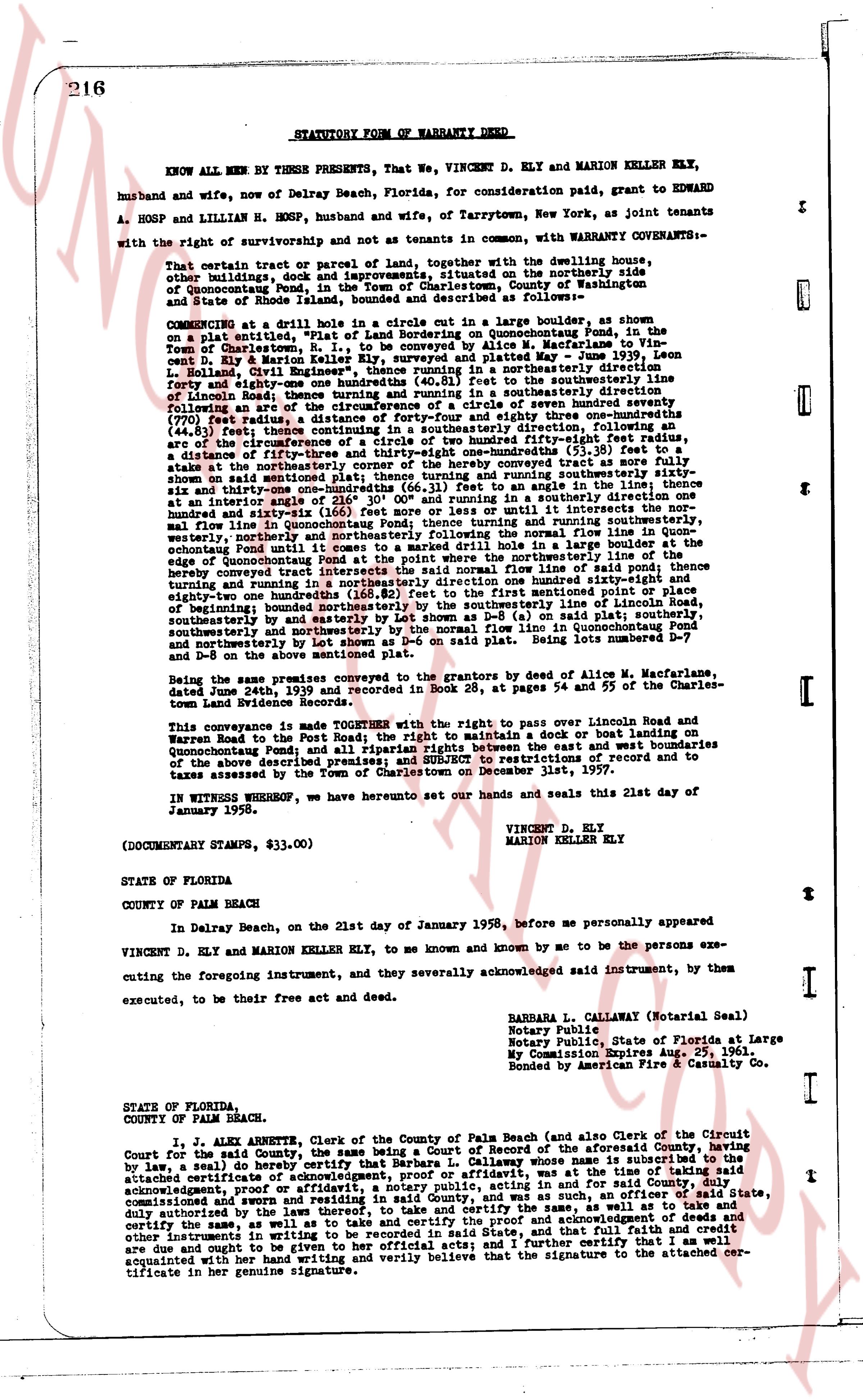
216 STATUTORY FORM OF WARRANTY DEED
KNOW ALL MEN BY THESE PRESENTS, That We, VINCENT D. ELY and MARION KELLER ELY, husband and wife, now of Delray Beach, Florida, for consideration paid, grant to EDWARD A. HOSP and LILLIAN H. HOSP, husband and wife, now of Tarrytown, New York, as joint tenants with the right of survivorship and not as tenants in common, with WARRANTY COVENANTS:—
That certain tract or parcel of land, together with the dwelling house, other buildings, dock and improvements situated on the northerly side of Quonochontaug Pond, in the Town of Charlestown, County of Washington, State of Rhode Island, bounded and described as following: as follows:
commencing at drill hole in a stone fence, marked in a large boulder, as shown on a plat exhibit "A", attached hereto and incorporated in this deed, on the shoreline of Quonochontaug Pond, in the Town of Charlestown, R.I., to be conveyed by Allen W. MacFarland to Vincent D. Ely and Marion Keller Ely, as recorded in the Land Evidence Records May 1936 Book 15on L. Kelland, Court Street, Charlestown; thence running northerly in a northeasterly direction forty-eight and one eighty-ninths hundredths one (40.81) feet to the shoreline of Quonochontaug Pond; thence running along the shoreline in a southeasterly direction following an arc of the circumference of a circle of seven hundred seventy seven (777) feet radius to a stone fence, marked in a large boulder eighty three hundredths (83.00) feet (44.31) feet there; continuing in a southeasterly direction, following an arc of the circumference of a circle of seven hundred seventy seven (777) feet radius to a stone fence, marked in a large boulder fifty-five and one hundredths (55.01) feet, a distance of fifty-three and thirty-eight one hundredths (53.38) feet to a stone fence, marked in a large boulder; thence turning and running southeasterly as shown on said mentioned plat; thence turning and running southeasterly sixty-six and thirty-one hundredths (66.31) feet, as shown on the angle line of the plat, at an interior angle of 21° 30' 00" and running in a southeasterly direction one hundred and sixty-three and one hundredths (163.01) feet to the normal flow line of Quonochontaug Pond; thence turning and running southeasterly, westerly northerly to a stone fence, marked in a large boulder fifty-five and one hundredths (55.01) feet until it does meet a marked drill hole in a large boulder at the edge of Quonochontaug Pond to the point of beginning; said normal flow line of the shoreline hereby conveyed traces the northwesterly shore of said normal flow line of said pond; thence turning and running in a northeasterly direction one hundred ninety-one and one hundredths (191.01) feet to the shoreline of the pond at the first mentioned point or place of beginning; bounded northwesterly by the southeasterly line of income Road, southeasterly by the shoreline of Quonochontaug Pond (or said normal flow line), southwesterly and northeasterly by the normal flow line in Quonochontaug Pond and northeasterly by the shoreline of said Pond. Being lots numbered D-1 and D-8 on the above mentioned plat.
Being the same premises conveyed by the grantors by deed of Allen W. MacFarland, dated June 24th, 1936 and recorded in Book 35, at pages 54 and 55 of the Charlestown Land Evidence Records.
This conveyance is made TOGETHER with the right of way pass over Income Road and Warren Roads to the Pond; the right to build a dock or boat landing on Quonochontaug Pond and all riparian rights between the east and west boundaries of the above described premises; and SUBJECT to restrictions of record and to taxes assessed by the Town of Charlestown on December 1st, 1957.
IN WITNESS WHEREOF, we hereunto set our hands and seals this 21st day of January 1958.
VINCENT D. ELY
MARION KELLER ELY
(DOCUMENTARY STAMPS, $33.00)
STATE OF FLORIDA
COUNTY OF PALM BEACH
In Delray Beach, on the 21st day of January 1958, before me personally appeared VINCENT D. ELY and MARION KELLER ELY, to me known and known by me to be the persons executing the foregoing instrument, and they severally acknowledged said instrument, by them executed, to be their free act and deed.
BARBARA L. CALLAWAY (Notarial Seal)
Notary Public
Notary Public, State of Florida at Large
My Commission Expires Aug. 29, 1961.
Bonded by American Fire & Casualty Co.
STATE OF FLORIDA
COUNTY OF PALM BEACH.
I, J. ALAN ALBERTE, Clerk of the County of Palm Beach (and also Clerk of the Circuit Court for the said County, the same being a Due record of the aforesaid County, having been by law, a seal) do hereby certify that Barbara L. Callaway, whose name is affixed to the attached certificate of acknowledgment and whose affidavit, was at the time of taking said acknowledgment, proof or affidavit, a notary public, acting in and for said County, duly commissioned and sworn, and residing in such a county, an officer of said State, duly authorized by the laws thereof, to take and certify the same, as well as to take and certify the same, as well as to take and certify the same, acknowledgments, proofs and other instruments in writing to be recorded in said State, and that full faith and credit are due and ought to be given to her official acts; and I further certify that I am acquainted with her handwriting and verily believe that the signature to the attached certificate in her genuine signature.
page 2 · read by Gemma vision
217
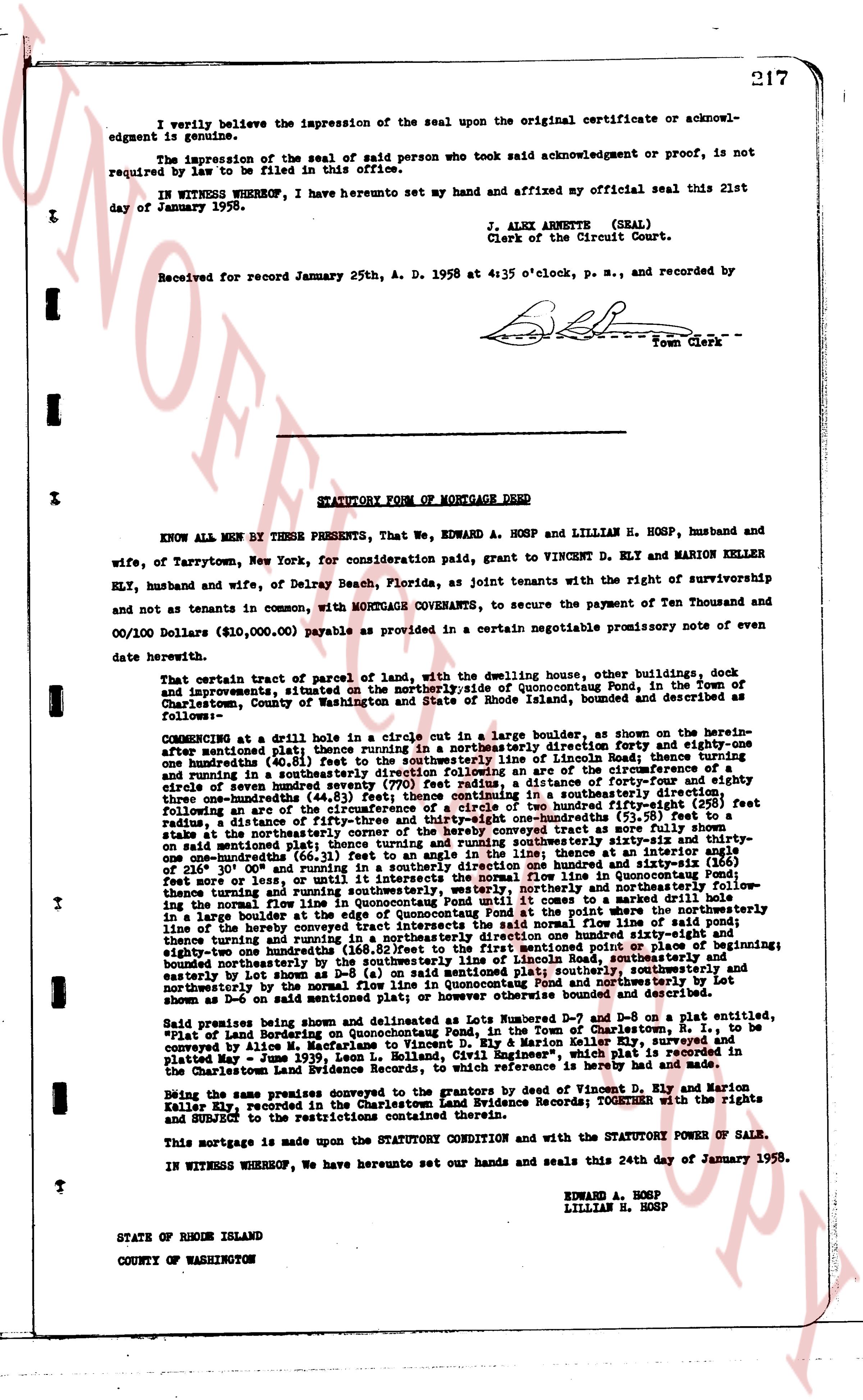
I verily believe the impression of the seal upon the original certificate or acknowledgment is genuine.
No impression of the seal of said person who took said acknowledgment or proof, is not required by law to be filed in this office.
IN WITNESS WHEREOF, I have hereunto set my hand and affixed my official seal this 21st day of January 1958.
J. ALEX ARNETTE (SEAL)
Clerk of the Circuit Court.
Received for record January 25th, A. D. 1958 at 4:35 o'clock, p. m., and recorded by
[Signature]
Town Clerk
----
STATUTORY FORM OF MORTGAGE DEED
KNOW ALL MEN BY THESE PRESENTS, That We, EDWARD A. HOSP and LILLIAN H. HOSP, husband and wife, of Tarrytown, New York, for consideration paid, grant to VINCENT D. ELY and MARION KELLER ELY, husband and wife, of Delray Beach, Florida, as joint tenants with the right of survivorship and not as tenants in common, with MORTGAGE COVENANTS, to secure the payment of Ten Thousand and 00/100 Dollars ($10,000.00) payable as described in a certain negotiable promissory note of even date herewith.
That certain tract of parcel of land, with the dwelling house, other buildings, dock and improvements, situated on the northerlyside of Quonoccutong Ponds, in the Town of Charlestown, County of Washington and State of Rhode Island, bounded and described as follows:
COMMENCING at a drill hole in a borehole cut in a large boulder, as shown on the herein attached map; thence running in a northeasterly direction forty and eight-one hundredths (40.81) feet; thence running in a northeasterly direction along the Lincoln Road boundary line one hundredths (100.00) feet; thence running in a southeasterly direction along an arc of the circumference of a circle of seven hundred seventy (770) feet radius, a distance of forty-four and eighty-one hundredths (44.81) feet; thence running in a southeasterly direction one hundred and twenty-five feet following an arc of the circumference of a circle of two hundred fifty-five fifty-eight (255.58) feet radius, a distance of one hundred and twenty-five feet; thence running in a southeasterly direction to a stake at the northeasterly corner of the hereby conveyed tract as more fully shown on said attached map, a distance of one hundred and twenty-five feet; thence running in a southeasterly direction one-hundreds (66.31) feet or until it intersects the normal flow line in Quonoccutong Pond; thence running along said normal flow line in a southeasterly direction one hundred and twenty-five feet more or less, or until it intersects the normal flow line in Quonoccutong Pond; thence running and turning along said normal flow line in a southeasterly direction one hundred and twenty-five feet more or less, or until it intersects the normal flow line in Quonoccutong Pond; thence turning and running in a southeasterly direction one hundred and twenty-five feet more or less, along the normal flow line in Quonoccutong Pond until it comes to a marked drill hole in a large boulder at the edge of the pond; thence running in a southwesterly direction one hundred and twenty-five feet more or less, until it intersects the normal flow line of said pond; thence turning and running in a northeasterly direction one hundred and twenty-five feet more or less, thence turning and running in a northeasterly direction one hundred and twenty-five feet more or less, until it reaches the point of commencement or point of beginning; southeasterly one hundred ninety-one hundredths (191.00) feet; bounded southeasterly and southeasterly by one hundred ninety-one hundredths (191.00) feet; bounded southeasterly, southeasterly and northeasterly by the normal flow line in Quonoccutong Pond and northeasterly by Lot No. 8 as set out on said map and as more fully described in the attached map.
Said premises being and denoted as Lots Numbered D-7 and D-8 on a plat entitled, "Plot of Land Bordering on Quonoccutong Pond, in the Town of Charlestown, State of Rhode Island" surveyed by Elias S. S. S. S. S. S. S. S. S. S. S. S. S. S. S. S. S. S. S. S. S. S. S. S. S. S. S. S. S. S. S. S. S. S. S. S. S. S. S. S. S. S. S. S. S. S. S. S. S. S. S. S. S. S. S. S. S. S. S. S. S. S. S. S. S. S. S. S. S. S. S. S. S. S. S. S. S. S. S. S. S. S. S. S. S. S. S. S. S. S. S. S. S. S. S. S. S. S. S. S. S. S. S. S. S. S. S. S. S. S. S. S. S. S. S. S. S. S. S. S. S. S. S. S. S. S. S. S. S. S. S. S. S. S. S. S. S. S. S. S. S. S. S. S. S. S. S. S. S. S. S. S. S. S. S. S. S. S. S. S. S. S. S. S. S. S. S. S. S. S. S. S. S. S. S. S. S. S. S. S. S. S. S. S. S. S. S. S. S. S. S. S. S. S. S. S. S. S. S. S. S. S. S. S. S. S. S. S. S. S. S. S. S. S. S. S. S. S. S. S. S. S. S. S. S. S. S. S. S. S. S. S. S. S. S. S. S. S. S. S. S. S. S. S. S. S. S. S. S. S. S. S. S. S. S. S. S. S. S. S. S. S. S. S. S. S. S. S. S. S. S. S. S. S. S. S. S. S. S. S. S. S. S. S. S. S. S. S. S. S. S. S. S. S. S. S. S. S. S. S. S. S. S. S. S. S. S. S. S. S. S. S. S. S. S. S. S. S. S. S. S. S. S. S. S. S. S. S. S. S. S. S. S. S. S. S. S. S. S. S. S. S. S. S. S. S. S. S. S. S. S. S. S. S. S. S. S. S. S. S. S. S. S. S. S. S. S. S. S. S. S. S. S. S. S. S. S. S. S. S. S. S. S. S. S. S. S. S. S. S. S. S. S. S. S. S. S. S. S. S. S. S. S. S. S. S. S. S. S. S. S. S. S. S. S. S. S. S. S. S. S. S. S. S. S. S. S. S. S. S. S. S. S. S. S. S. S. S. S. S. S. S. S. S. S. S. S. S. S. S. S. S. S. S. S. S. S. S. S. S. S. S. S. S. S. S. S. S. S. S. S. S. S. S. S. S. S. S. S. S. S. S. S. S. S. S. S. S. S. S. S. S. S. S. S. S. S. S. S. S. S. S. S. S. S. S. S. S. S. S. S. S. S. S. S. S. S. S. S. S. S. S. S. S. S. S. S. S. S. S. S. S. S. S. S. S. S. S. S. S. S. S. S. S. S. S. S. S. S. S. S. S. S. S. S. S. S. S. S. S. S. S. S. S. S. S. S. S. S. S. S. S. S. S. S. S. S. S. S. S. S. S. S. S. S. S. S. S. S. S. S. S. S. S. S. S. S. S. S. S. S. S. S. S. S. S. S. S. S. S. S. S. S. S. S. S. S. S. S. S. S. S. S. S. S. S. S. S. S. S. S. S. S. S. S. S. S. S. S. S. S. S. S. S. S. S. S. S. S. S. S. S. S. S. S. S. S. S. S. S. S. S. S. S. S. S. S. S. S. S.
The page as recorded