The instrument's own words
page 1 · read by Gemma vision
125
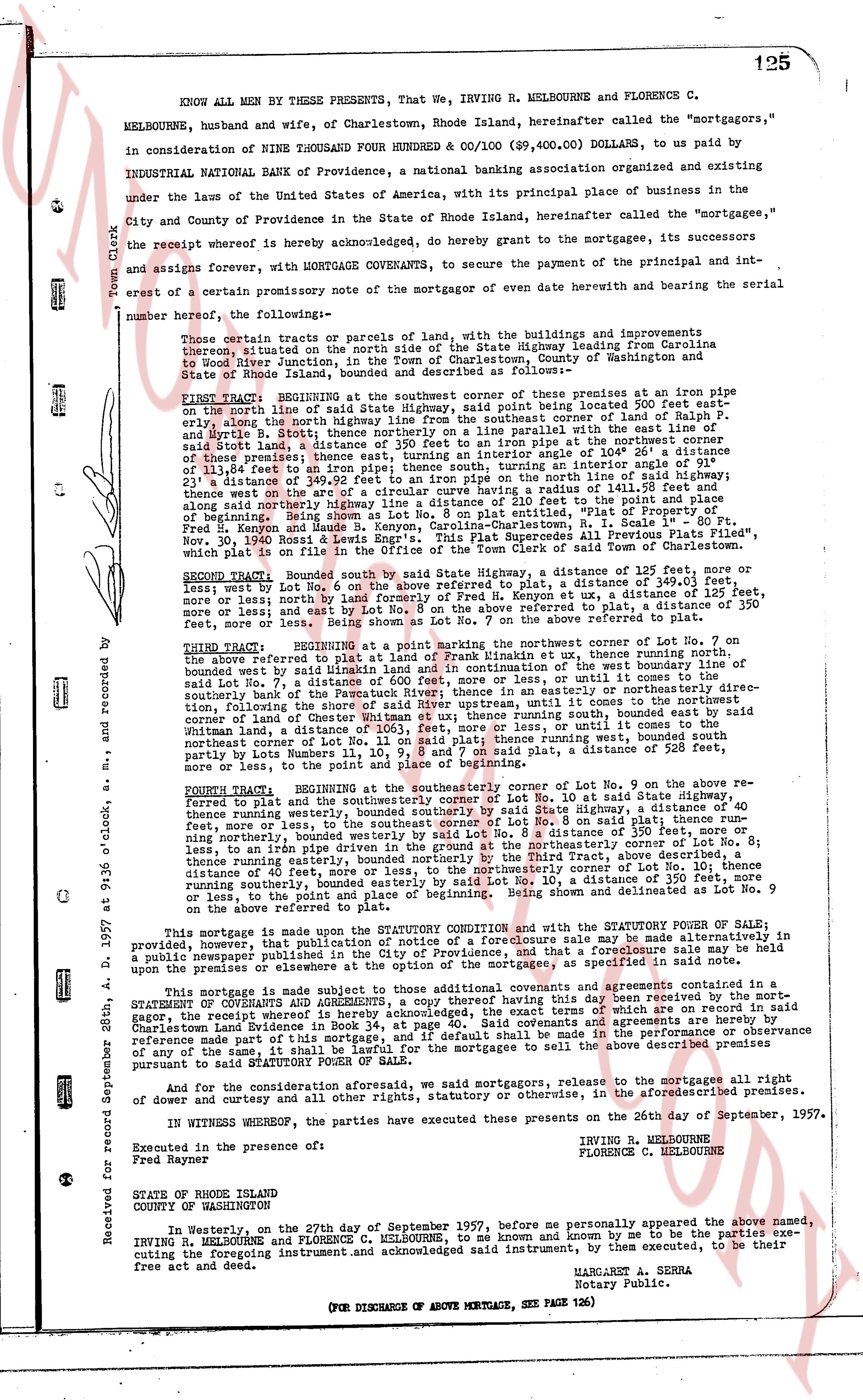
KNOW ALL MEN BY THESE PRESENTS, that We, IRVING R. MELBOURNE and FLORENCE C.
MELBOURNE, husband and wife, of Charlestown, Rhode Island, hereinafter called the "mortgagors,"
in consideration of NINE THOUSAND FOUR HUNDRED POUNDS & CO/100 ($9,400.00) DOLLARS, to us paid by
INDUSTRIAL NATIONAL BANK OF PROVIDENCE, a national banking association organized and existing
under the law of the United States of America, with its principal place of business and existing
in the City and County of Providence in the State of Rhode Island, hereinafter called the "mortgagee,"
the receipt whereof is hereby acknowledged, do hereby grant to the mortgagee, its successors
and assigns forever, with MORTGAGE COVENANTS, to secure the payment of the principal and in-
terest of a certain promissory note of the mortgagor or event due herewith and bearing the serial
number hereof, the followings-
These certain tracts or parcels of land with, the buildings and improvements
thereon, situated on the north side of the State Highway leading from Carolina
to Wood River Junction, in the Town of Charlestown, County of Washington and
State of Rhode Island, bounded as described as follows-
FIRST TRACT: BEGINNING at the southwest corner of these premises at an iron pipe on
the northern line of said State Highway, said point being located 500 feet eastly,
else north west from the southeast corner of Lot No. 8 on plat 10, as shown by
P. and Myrrh B. Stott; thence northerly on a line parallel eastly with the east line of
said Lot No. 8, a distance of 140 feet, to the northwest corner of the first of
these premises; thence east, entering an interior angle of 104 1/2 degrees 46' a
distance of 125 feet, to the northeast corner of these premises; thence southerly, an interior angle of 115 1/2
degrees 23' a distance of 349.92 feet to an iron pipe on the north line of said highway; with
straight line connecting the two points, describing an arc of radius of 111 feet, to the point of
of beginning. Then along said highway line a distance of 210 feet to the point and place
of beginning. Then said Lot as shown on Plat No. 10, entitled "Plat of 10,
Free and Associates' Land, Charlestown, R.I. Scale 1" = 20' Ft. Proven
Nov. 30, 1946 Ross & Lewis Eng's Office. This Plat Supersedes all Plats previously filed,
which plat is recorded in the Charlestown land-evidence book 31, page 230, in the office of said Town of Charlestown.
SECOND TRACT: Bounded south by said State Highway, a distance of 125 feet, more or
less; by west Lot No. 6 on the above referred to plat, a distance of 349.92 feet, more or
less; by north Lot No. 7 on the above referred to plat, a distance of 125 feet,
more or less; and by east Lot No. 8 on the above referred to plat, a distance of 350 feet,
more or less, to the point and place of beginning.
THIRD TRACT: BEGINNING at a point marking the northwest corner of Lot No. 7 on
the above referred to plat at Land of Frank minimax et ux, thence running southwesterly, a
distance of 125 feet, more or less, to the point marking the west corner of the west line of
said Lot No. 7, thence running westerly a distance of 600 feet, more or less, until it comes to the
southerly bank of the Pawcatuck River, thence running easterly, along said river, until it comes to the
northwest corner of Land of Whitman et ux, thence running south, until it comes to the
corner of land of Chester Whitman et ux, thence running easterly, until it comes to the
northwest corner of Lot No. 11 on said plat; thence running west, bounded southly
by partly the State Highway, a distance of 600 feet, more or less, until it comes to the
northeast corner of Lot No. 11 on said plat; thence running west, bounded southly
by partly the State Highway, a distance of 125 feet, more or less, until it comes to the
point, more or less, to the point and place of beginning. Being shown and delimited as Lot No. 7
FOURTH TRACT: BEGINNING at the southeasterly corner of Lot No. 9 on the above re-
ferred plat, a distance of 125 feet, more or less, to Lot No. 10 at said State Highway, thence
running westerly, bounded southerly by said State Highway, a distance of 40
feet, more or less; then running northerly, bounded westerly by said Lot No. 8, a distance of 350 feet, more or
less; then running northerly, bounded westerly by said Lot No. 8, a distance of 81
feet, more or less, to an iron pipe driveway, bounded northerly by the Third Tract, above described,
thence running easterly, bounded northerly by the Third Tract, above described, a
distance of 40 feet, more or less, to the northeasterly corner of the first of these premises,
thence running southerly, bounded easterly by Lot No. 10, a distance of 350 feet, more
or less, to the point and place of beginning. Being shown and delimited as Lot No. 9
This mortgage is made upon the STATE CONVEYANCING SYSTEM and with the STATUTORY POWER OF SALE;
provided, however, that publication of notice of a foreclosure sale may be made alternatively in
a public newspaper, or by mailing a notice of such sale to the Conveyancing System and to the mortgagor,
paid up the premises or elsewhere at the option of the mortgagee, as specified in said note.
This mortgage is made subject to those additional covenants and agreements contained in a
STATEMENT OF CONVEYANCING SYSTEM, recorded in the Charlestown land-evidence book 36, page 121,
said Receipt whereof is hereby acknowledged, the exact terms of which are on record in said
Charlestown Land Evidence book 36, page 121, a part of this mortgage, and incorporated herein
by this reference, provided, however, that if default shall be made in the performance or observance
of any of the same, it shall be lawful for the mortgagee to sell the above described premises
pursuant to said statement.
And for the consideration and aforesaids, we said mortgagors, release to the mortgagee all right
of dower and curtesy and all other rights, statutory or otherwise, in the aforementioned premises.
IN WITNESS WHEREOF, the parties have executed this present on the 26th day of September, 1957.
Executed in the presence of
Fred Rayner
IRVING R. MELBOURNE
FLORENCE C. MELBOURNE
STATE OF RHODE ISLAND
COUNTY OF WASHINGTON
In Westerly, on the 27th day of September 1957, before me personally appeared the above named,
IRVING R. MELBOURNE and FLORENCE C. MELBOURNE, to me known and by me to be the parties exe-
cuting the foregoing instrument.And acknowledged said instrument, by them executed, to be their
free acting and deed.
MARGARET A. SERRA
Notary Public.
(FOR DISCHARGE OF ABOVE MORTGAGE, SEE PAGE 136)
The page as recorded