The instrument's own words
page 1 · read by Gemma vision
122
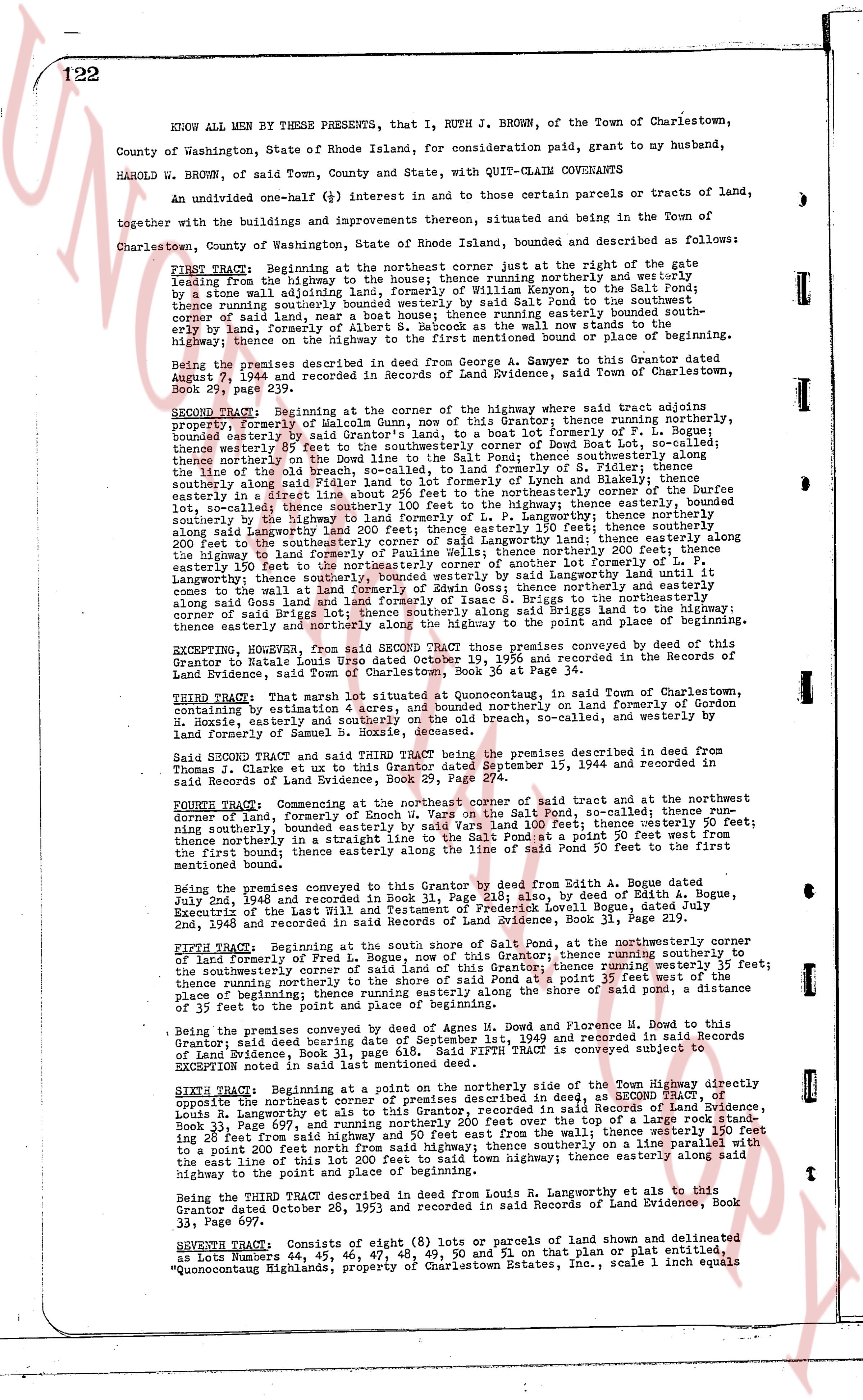
KNOW ALL MEN BY THESE PRESENTS, that I, RUTH J. BROWN, of the Town of Charlestown,
County of Washington, State of Rhode Island, for consideration paid, grant to my husband,
HAROLD W. BROWN, of said Town, County and State, with QUIT-CLAIM CONVEYANCE
An undivided one-half (½) interest in and to those certain parcels or tracts of land,
together with the buildings and improvements thereon enterprised, situated and being in the Town of
Charlestown, County of Washington, State of Rhode Island, bounded and described as follows:
FIRST TRACT: Beginning at the northeast corner just at the right of the gate
leading from the highway to the house; thence running northerly and westerly
by a stone wall leading to the house; thence easterly by said house to the southeast corner of said house; thence southerly by said wall to the South property
corner of said land, near a neat house boat; thence running easterly bound by south-
erly side of land, formerly of Mrs. Sarah S. Brown, to said wall now stands to the
highway; thence on the highway to the first mentioned point or boundary place Beginning.
Being the premises described in the deed from George A. Sawyer to this Grantor dated
August 19, 1906 and recorded in said Records of Land Evidence, said Town of Charlestown, Book
29, page 239.
SECOND TRACT: Beginning at the corner of the highway where said tract adjoins
property formerly of Salome Gulls, now of this Grantor; thence running northerly,
bounded easterly by said Grantor's land, to a boat mark first lot of F. P. Lugey; thence
westerly about 55 feet; thence northerly by the boundary of Owen Bot Land to the first
lot of F. P. Lugey; thence northerly on the Bound Line to the salt Fen; thence southerly along
the boundary of Owen Bot Land to the southeast corner of F. Lugey; thence easterly
along the line of old Breach, so-called; thence northerly by the boundary of formerly of Lynch and Blakely; thence
southerly along said Breach to the boundary of formerly of Lynch and Blakely; thence
easterly in a direct line about 20% feet from the northeasterly corner to the southeast corner
of said Breach, so-called; thence southerly to the highway; thence easterly, bounded
southerly by the highway to the land formerly of F. P. Lugey; thence northerly along
said highway to the northeast corner of said highway; thence northerly 200 feet; thence easterly along
200 feet to the southeasterly corner of said langworthy land; thence easterly along the
said highway to the northeast corner of said langworthy land; thence northerly along
easterly 150 feet to the northeasterly corner of another lot easterly to F. P. Lugey;
thereafter thence northerly along the boundary of said langworthy land to the northeast corner of said
lot until it comes to the wall land of formerly Edwin Joss; thence gorthly and easterly
along said wall to the northeast corner of said land; thence easterly along the boundary of
corner of said Briggs lot; thence southerly along said Briggs to the highway and place
thence easterly and northerly along the highway to the point and place first above Beginning.
EXCEPTING, HOWEVER, from said SECOND TRACT, those premises conveyed by deed in this
Grantor to Helen LaGrange dated September 19, 1956 and recorded in the Records of Land
Evidence, said Town of Charlestown, Book 36, page 134.
THIRD Tract: That certain lot situated at Conquetoneaug, in said Town of Charlestown,
bounded by estimation, northerly and easterly by the boundary on land of formerly Gordon
N. Hoxie, easterly and southerly on the old Breach, so-called, and westerly by land
formerly of Samuel G. Ames.
Said SECOND Tract and said THIRD Tract being the premises described in the deed from
Thomas J. Clarke et ux to this Grantor dated September 15, 1944 and recorded in
said Records of Land Evidence, Book 25, page 111.
FOURTH Tract: Commencing at the northeast corner of said tract and at the northwest
doorway of formerly of Enoch W. Vars on the Salt Fen, so-called; thence run easterly
about 100 feet; thence northerly by the boundary of Enoch W. Vars on the Salt Fen, 200 feet;
running southerly, bounded easterly by said Vars on the Salt Fen, to a point 20 feet west from
the first bound; thence easterly along the line of said Fen pointed to the first bound; thence
easterly about 100 feet.
Being the premises conveyed to this Grantor by deed from Edith A. Bogue dated
July 2nd, 1942 and recorded in Book 31, page 231, also by deed of Edith A. Bogue,
Executrix of the last will and testament of said Owen Bot, Book 19, page 119, and recorded in
2nd, 1948 and recorded in said Records of Land Evidence, Book 31, Page 239.
FIFTH TRACT: Beginning at the south shore of Salt Fen, at the northeasterly corner
of land formerly of F. P. Lugey; thence running northerly 35 feet; thence running easterly to
the southeasterly corner of said land of this Grantor; thence running westerly 35 feet;
thence running northerly to the shore of said Salt Fen at a point 35 feet easterly from the
place of beginning; thence running southerly to the shore of said Fen, a distance
of 35 feet to the point and place of beginning.
Being the premises conveyed by deed of Agnes M. Howe and Florence M. Howe to this
Grantor, said deed dated December 23, 1943, recorded in 1st, 1949 and recorded in said
of Land Evidence, Book 31, page 618. Said FIFTH TRACT is conveyed subject to
exceptions noted in said deed.
SIXTH TRACT: Beginning at a point on the northerly side of the Town highway directly
opposite the northeast corner of the premises described in SECOND TRACT, as recorded in
Land Evidence, Book 36, page 134, and recorded in said Records of Land Evidence,
Book 33, Page 697, and running northerly 200 feet over the top of a large rock stone
wall, bounded easterly by land formerly of R. Langworthy; thence southerly along said wall
to a point 200 feet south from said highway; thence southerly on a line parallel with
the east line of this 200 feet lot from said highway; thence easterly along said
highway to the point and place of beginning.
Being the THIRD TRACT described in deed from Louis R. Langworthy et al to this
Grantor dated October 28, 1953 and recorded in said Records of Land Evidence, Book
33, Page 697.
SEVENTH TRACT: Consists of eight (8) lots or parcels of land shown and delineated
as Lots Numbers 44, 45, 46, 47, 48, 49, 50 and 51 on that plan or plat entitled,
"Conoquoneaug Highlands, property of Charlestown Estates, Inc., scale 1 inch equals
page 2 · read by Gemma vision
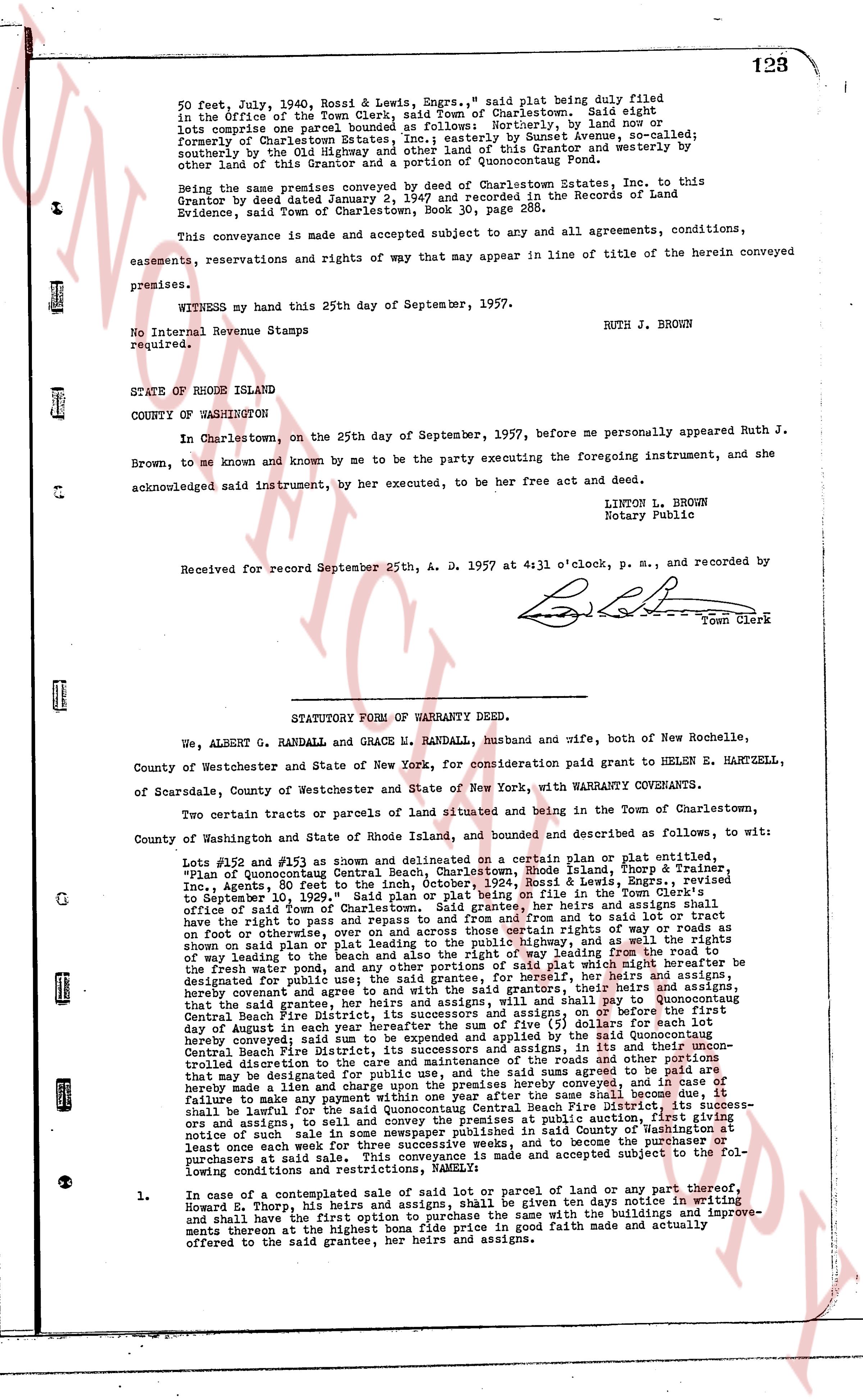
50 feet, July 1936, Bess & Lewis, Engrs.," said plat being duly filed
in the office of the Town Clerk, said Town of Charlestown. Said eight
lots comprise one parcel bounded as follows: Northerly, by land now or
formerly of Charlestown Estates, Inc.; easterly by Sunset Avenue, so-called;
southerly by the Old Highway leading from the land of this Grantor and westerly by
other land of this Grantor and a portion of Quonocontaug Pond.
Being the same premises conveyed by deed of Charlestown Estates, Inc. to this
Grantor by deed dated January 13, 1957 and recorded in the Records of Land
Evidence, said Town of Charlestown, Book 30, page 288.
This conveyance is made and accepted subject to any and all agreements, conditions,
easements, reservations and rights of way that may appear in line of title of the herein conveyed
premises.
WITNESS my hand this 25th day of September, 1957.
RUTH J. BROWN
No Internal Revenue Stamps
required.
STATE of RHODE ISLAND
COUNTY of WASHINGTON
In Charlestown, on the 25th day of September, 1957, before me personally appeared Ruth J.
Brown, to me known and known by me to be the party executing the foregoing instrument, and she
acknowledged said instrument, by her executed, to be her free act and deed.
LINTON L. BROWN
Notary Public
Received for record September 25th, A. D. 1957 at 4:31 o'clock, p. m., and recorded by
[signature]
Town Clerk
----
STATUTORY FORM OF WARRANTY DEED.
We, ALBERT G. RANDALL and GRACE M. RANDALL, husband and wife, both of New Rochelle,
County of Westchester and State of New York, for consideration paid grant to HELEN E. HARTZELL,
of Scarsdale, County of Westchester and State of New York, with WARRANTY COVENANTS.
Two certain tracts or parcels of land situated and being in the Town of Charlestown,
County of Washington and State of Rhode Island, and bounded and described as follows, to wit:
Lots #152 and #153 as shown and delineated on a certain plan or plat entitled,
"Plan of Quonocontaug Central Beach, Charlestown, Rhode Island," filed with the
Inc., Agent, 80 feet east of the center of Sunset Avenue, by Bess & Lewis, Engrs., revised
to September 19, 1929." Said plan or plat or being on file in the Town Clerk's office
of said Town, the said lots are bounded as follows: northerly, by land of their heirs and assigns and
the right have the right to pass and repass to and from and from to said lot or tract
feet on the easterly side of Sunset Avenue, the said right of way being as shown on the
shown on said plan or plat leading to the public highway, and as the well rights may hereafter be
of way leading to the public highway, and as the well rights may hereafter be
the fresh water pond, and any other portions of said plat which might hereafter be
designated for public use, and the said grant does not include the right of way leading to
hereby convey and agree to and with the said grants, their heirs and assigns,
called the Fire District, its successors and assigns, or on the before the first
day of August in each year hereafter the sum of $1.00 (One Dollar) shall be applied by the said Quonocontaug
Central Beach Fire District, its successors and assigns, in its use and possession
conveyed limited duration to the said Fire District, and the roads and other portions
that may be designated for public use, and the said sums agreed to be paid are
hereby secured by a lien upon the said premises hereby conveyed and the failure of
failure to make any payment within one year after the same said became due, it
hereby convey and agree to and with the said grants, their heirs and assigns, that they
ors and assigns, to sell and convey the premises at public auction, first giving
notice of sale by posting a notice thereon and in the Town Office of Charlestown, and by publishing
at least once each week for three successive weeks; and to become the purchaser or
purchasers at said sale unless the said premises are made and accepted subject to the fol-
lowing conditions and restrictions, NAMELY:
1. In case of a contemplated sale of said lot or parcel of land or part thereof,
Howard E. Thorp, his heirs and assigns, shall be given ten days notice in writing
and shall have first right to purchase said lot or parcel together with the buildings and improvements
thereon at the highest bona fide price in good faith made and actually
offered to the said grantee, her heirs and assigns.
The page as recorded