The instrument's own words
page 1 · read by Gemma vision
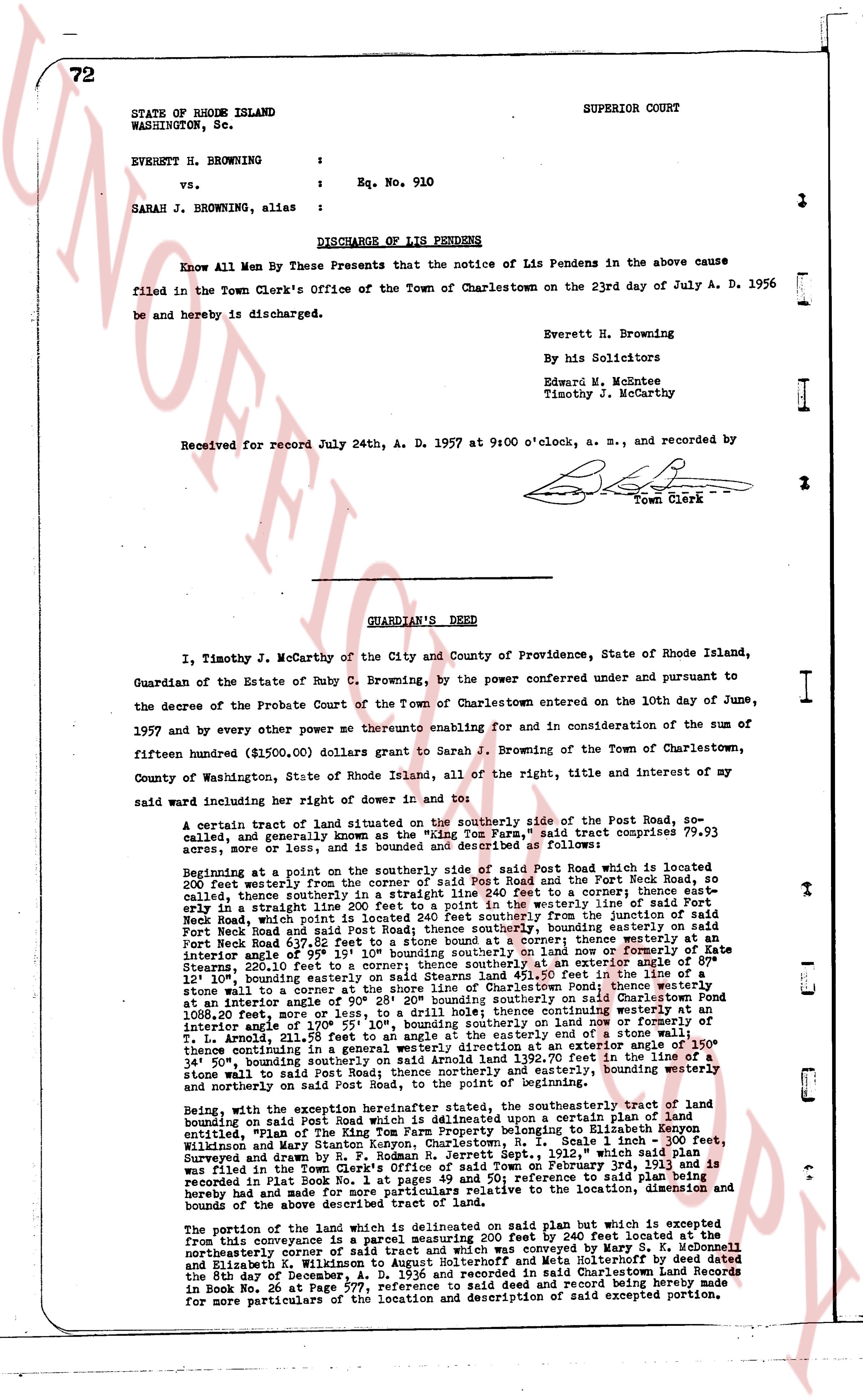
72
STATE OF RHODE ISLAND
WASHINGTON, Sc.
SUPERIOR COURT
EVERETT H. BROWNING
vs.
SARAH J. BROWNING, alias
:
: Eq. No. 910
:
DISCHARGE OF LIS PENDENS
Know All Men By These Presents that the notice of Lis Pendens in the above cause filed in the Town Clerk's Office of the Town of Charlestown on the 23rd day of July A. D. 1956 be and hereby is discharged.
Everett H. Browning
By his Solicitors
Edward W. McKenzie
Timothy J. McCarthy
Received for record July 24th, A. D. 1957 at 9:00 o'clock, a. m., and recorded by
[signature]
Town Clerk
----
GUARDIAN'S DEED
I, Timothy J. McCarthy of the City and County of Providence, State of Rhode Island, Guardian of the Estate of Ruby C. Browning, by the power conferred under and pursuant to the decree of the Probate Court of the Town of Charlestown entered on the 10th day of June, 1957 and by every other power me thereunto enabling for and in consideration of the sum of fifteen hundred ($1500.00) dollars grant to Sarah J. Browning of the Town of Charlestown, County of Washington, State of Rhode Island, all of the right, title and interest of my said ward including her right of dower in and to:
A certain tract of land situated on the southerly side of the Post Road, so called, and generally, and even known as the "Wing Tom Farm," said tract comprises 79.93 acres, more or less, and is bounded and described as follows:
Beginning at a point on the southerly side of said Post Road which is located 200 feet easterly from the junction of said Post Road and the Fort Neck Road, so called, thence southerly, thence southerly in a straight line 240 feet to a corner; thence westerly at an angle 87 1/2 degrees line 100 feet to a corner; thence westerly line of said Fort Neck Road, which point is located 240 feet southerly from the junction of said Fort Neck Road and said Post Road, thence southerly bounding easterly line of said Fort Neck Road 637.82 feet to a stone bound at a corner; thence westerly at an angle 108 degrees line 400 feet to a corner; thence southerly line of said farm 526.85 feet, 220.10 feet to a corner; thence southerly at an angle of 89 degrees 12' 10" bounding easterly line of said farm 100 feet to a corner; thence southerly to a stone wall to a corner at the shore line of Charlestown Pond; thence westerly at an angle 108 degrees line 400 feet to a corner; thence southerly bounding westerly line 1088.20 feet, more or less, to a drain; to a drill hole; thence continuing westerly at an angle 108 degrees line 400 feet to a corner; thence westerly at an angle 108 degrees line 211.58 feet to an angle at the easterly end of a stone wall 100 feet continuing in a general westerly direction to a corner at an angle 108 degrees 30' thence continuing in a general westerly direction 1392.70 feet to a line on the 340 1/2 degree bounding northerly line of said farm; thence easterly bounding northerly line to a stone wall to said Post Road thence northerly and easterly, bounding westerly and northerly line of said farm to the point of beginning.
Being, with the exception herein hereinafter stated, the southeasterly tract of land bounding on said Post Road which is delineated upon a certain plan of land mentioning "Wing Tom Farm" and submitted to Binghamton New York by Charleston Wilkinson and Mary Stanton Kenyon Charlestown, R.I. Scale 1 inch = 300 feet, Surveyed and drawn by them in the month of June, 1913 which plan and survey was filed in the Town Clerk's Office of said Town on February 3rd 1913 and is recorded in First Book Rd. 1 at page 147. All such reference to said plan is hereby read and made a part of this conveyance referring to the location, dimension and bounds of the above described tract of land.
The portion of the land which is delineation on said plan but which is excepted from this conveyance is a portion bounding 200 feet by 240 feet located at the northeasterly corner of said tract and which was conveyed by Mary Stanton Kenyon and Elizabeth S. Wilkinson to Charles H. Browning and Meta Holtheroff by deed dated the 8th day of December, A. D. 1936 and recorded in said Charlestown Land Records in Book Rd. 36 at Page 771. All such reference and record made herein is made for more particulars of the location and description of said excepted portion.
page 2 · read by Gemma vision
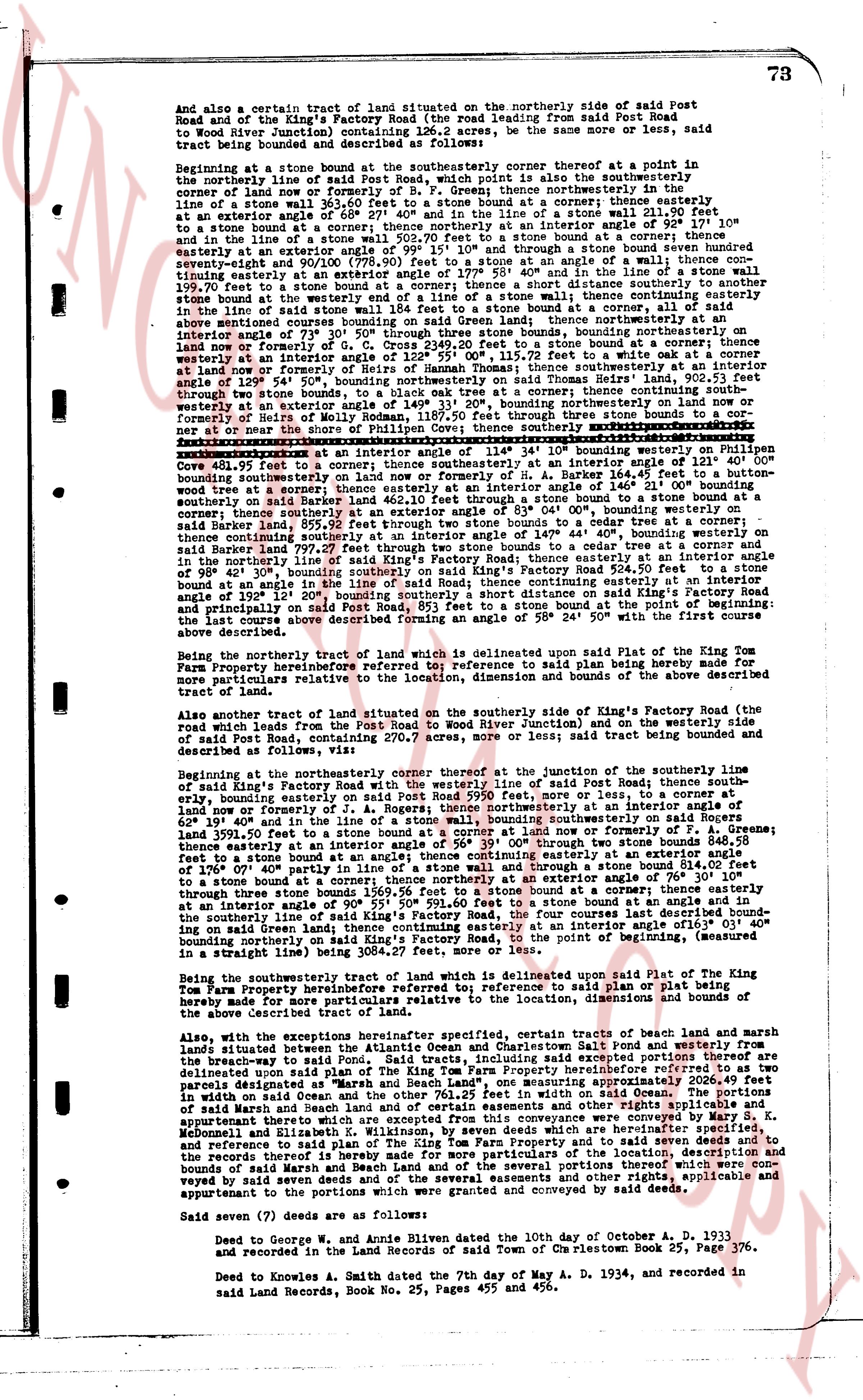
73
And also a certain tract of land situated on the northerly side of said Post Road and east of the King's Factory Road (the road leading from said Post Road to Wood River Junction) containing 126.2 acres, be the same more or less; said tract being bounded and described as follows:
Beginning at a stone at a stone bound at the southerly corner before at a point in the northerly line of said Post Road; thence running northerly along the easterly boundary of corn land of now or formerly of B. F. Greeny thence northwesterly in the line of a stone wall 36.58 feet to an interior angle of 69° 27' and then in the line of a stone wall 211.90 feet to a stone bound at a corner; thence northwesterly at an interior angle of 78° 10' and 10" to a stone bound at a corner; thence northerly at an interior angle of 68° 10' and 10" in the line of a stone wall 111.10 feet to a stone bound at a corner; thence easterly at an interior angle of 99° 15' 10" and through a stone bound seven hundred seventy-seven feet to a stone bound at a corner; interior angle of 81° 10' and 10" continuing easterly at an interior angle of 177° 53' 40" and in the line of a stone wall 199.70 feet to a stone bound at a corner; thence southerly at an interior angle of 81° 10" to a stone bound at a corner; thence southerly in the line of a stone wall 111.10 feet to a stone bound; thence continuing easterly along the above mentioned survey boundaries crossing on said Greeny land said stone bound and in the line of a stone wall; thence continuing easterly in the line of said stone wall 111.10 feet to a stone bound and a corner; thence continuing easterly on land now or formerly of G. C. Cross 2349.20 feet to a stone bound at a corner; thence southeasterly at an interior angle of 101° 10" and then in a line of a stone wall 111.10 feet to a stone bound on land now or formerly of Heirs of Hannah Thomas; thence southeasterly at an interior angle of 129° 50' 30", bounding northerly on land now or formerly of B. F. Greeny, 270 feet to a stone bound at a corner; thence continuing southeasterly at an interior angle of 149° 31' 20", bounding northerly on land now or formerly of B. F. Greeny, 111.10 feet to a stone bound at a corner; thence southeasterly in the line of a stone wall 111.10 feet to a stone bound at a corner or near the shore of Philippines Cove; thence southeasterly moving in the line of a stone wall 111.10 feet to a stone bound at a corner; thence southeasterly at an interior angle of 114° 36' 10" bounding northerly on Philippines Cove, 68.10 feet to a stone bound at a corner; thence southeasterly at an interior angle of 80° 10" bounding southeasterly on land now or formerly of H. A. Barker 164.45 feet to a button-wood tree at a corner; thence southeasterly in the line of a stone wall 111.10 feet to a stone bound on said Barker land 463.10 feet to a stone bound to a stone bound at a corner; thence southeasterly at an interior angle of 140° 10" and then in the line of said Barker land 859.77 feet, 95.22 feet through two stone bounds to a red oak tree at a corner; thence continuing southeasterly at an interior angle of 140° 10" and then 140.80 feet to a stone bound on said Barker land 799.27 feet, 0.27 feet through two stone bounds to a cedar tree at a corner and a stone bound at a corner; thence southeasterly at an interior angle of 140° 10" bounding southerly in the northerly line of said King's Factory Road, thence southerly 520.94 feet to a stone bound at an angle in the line of said road; thence continuing easterly at a interior angle of 152° 10' 20" bounding southerly on said King's Factory Road, 111.10 feet on said Factory Road and principally on said Post Road, 853 feet to a stone bound at the point of beginning; the last course being measured in a straight line between the two stone bounds.
Being the northerly, third tract of land which is delineated upon said Plat of the King Tom Farm Property before referred to; reference to said plan being hereby made for more particulars relative to the location, dimension and bounds of the above described tract of land.
Also another tract of land situated on the southerly side of King's Factory Road (the road which leads from the Post Road to Wood River Junction) and on the westerly side of said Post Road, containing 27.07 acres, more or less; said tract being bounded and described as follows:
Beginning at the cornerly corner thereof at the junction of the southerly line of said King's Factory Road with the westerly line of said Post Road; thence south easterly, bounding easterly on said Post Road, 111.10 feet, more or less; thence southeasterly on land now or formerly of J. A. Rogers; thence northwesterly at an interior angle of 68° 10' and 10" and in the line of a stone wall 111.10 feet to a stone bound at a corner; thence northwesterly on land now or formerly of P. A. Greene; thence northwesterly at an interior angle of 81° 10" and then in the line of a stone wall 3591.50 feet to a stone bound at a corner; thence continuing northwesterly at an interior angle of 76° 30' 10" and then in the line of a stone wall 111.10 feet to a stone bound at an angle; thence continuing northwesterly at a corner; thence northerly at an interior angle of 76° 30' 10" through three stone bounds to a stone bound at a corner; thence northerly at an interior angle of 76° 30' 10" and then 595° 50' 53.60 feet to a stone bound at an angle and in the southerly line of said King's Factory Road, the four course bounding the northwesterly line of said tract being measured in a straight line; thence at an interior angle 061° 03' 09" southeasterly bounding northerly on said King's Factory Road, to the point of beginning, (measured in a straight line between the two stone bounds).
Being the southeasterly fourth tract of land which is delineated upon said Plat of the King Tom Farm Property before referred to; reference to said plan or plat being hereby made for more particulars relative to the location, dimension and bounds of the above described tract of land.
Also, with the exception of the heretofore specified, certain tracts of beach land and marsh lands situated between the Atlantic Ocean and Charlestown Salt Pond and westerly from the breakwater on said pond in said tracts, including said excepted portions therefore as delineated upon said Plan of the King Tom Farm Property before referred to, containing approximately 206.46 feet in width on said Ocean and the other 761.25 feet in width on said Ocean. The portions of said beach and pond lands and marsh lands and other lands and water rights and apartment thereto which are excepted from this conveyance were conveyed by Mary S. K. McMonagle from Elizabeth McMonagle to the heirs of Hannah Thomas by a deed of date and reference to said plan of The King Tom Farm Property and to said seven deeds and to the easterly boundary of the beach and pond lands and marsh lands and other lands and bounds of said Marsh and Beach lands of the several portions thereof which were conveyed by said seven deeds and of the several easements and other rights thereto applicable and appurtenant to the portions which were granted and conveyed by said deeds.
Said seven (7) deeds are as follows:
Deed to George W. and Annie Bliven dated the 10th day of October A. D. 1933 and recorded in the Land Records of said Town of Charlestown Book 25, Page 376.
Deed to Knowles A. Smith dated the 7th day of May A. D. 1934, and recorded in said Land Records, Book No. 25, Pages 455 and 456.
page 3 · read by Gemma vision
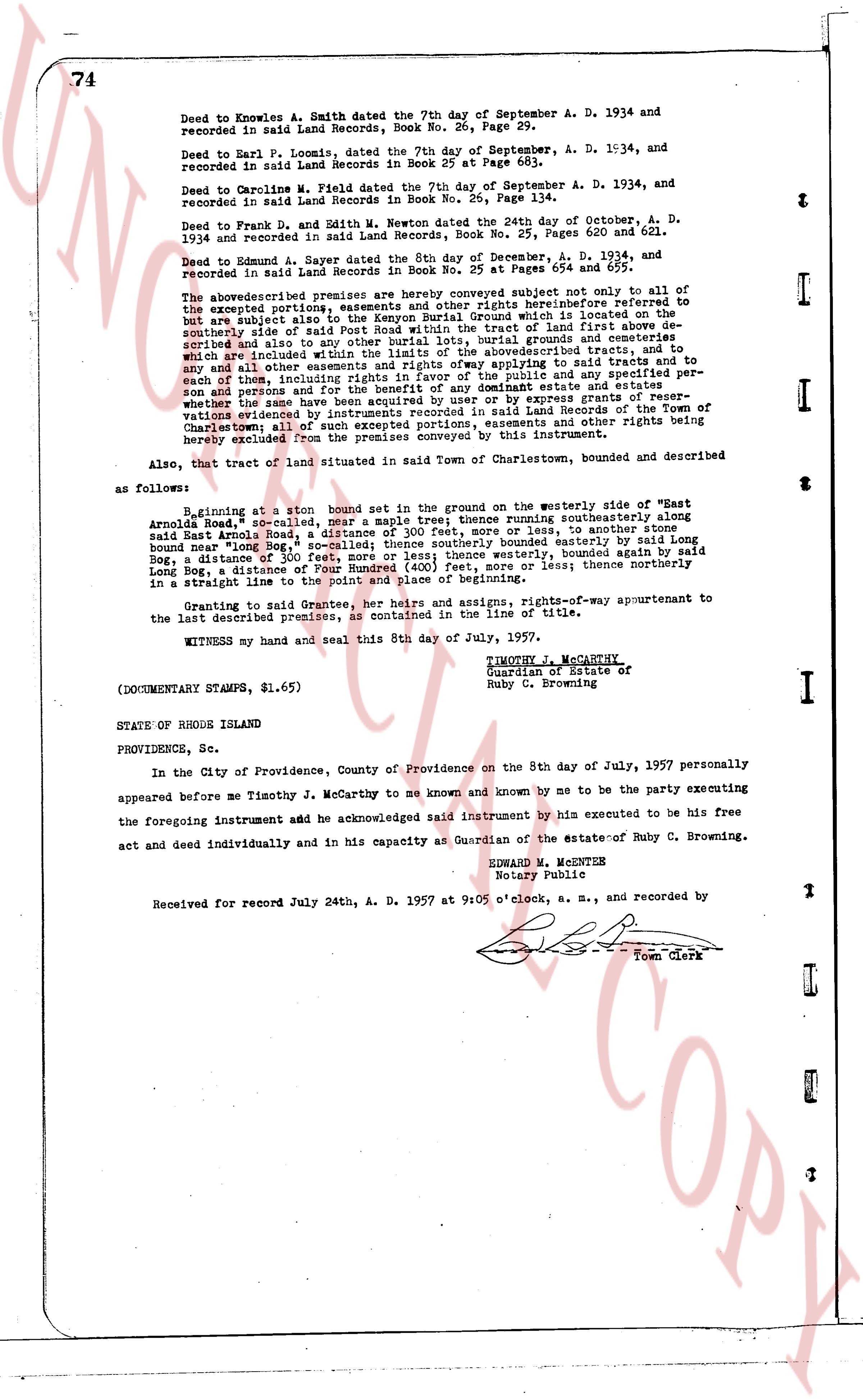
74
Deed to Knowles A. Smith dated the 7th day of September A. D. 1934 and recorded in said Land Records, Book No. 26, Page 29.
Deed to Earl P. Loomis, dated the 7th day of September, A. D. 1934, and recorded in said Land Records in Book 25 at Page 683.
Deed to Caroline M. Field dated the 7th day of September A. D. 1934, and recorded in said Land Records, Book No. 25, Page 134.
Deed to Frank D. and Edith M. Newton dated the 24th day of October, A. D. 1934 and recorded in said Land Records, Book No. 25, Pages 620 and 621.
Deed to Edmund A. Sayler dated the 5th day of December, A. D. 1934, and recorded in said Land Records in Book No. 25 at Pages 654 and 657.
The above described premises are hereby conveyed subject not only to all of the excepted portions, reservations and rights hereinafter referred to but are subject also to the Kenyon Burial Ground which is situated on the southeasterly side of said land, being a tract of land of first about described and also to any other burial lots, burial grounds and cemeteries which are included within the boundaries of the above described tracts, and to any and all other easements and rights of way appertaining to said tracts and to each of said lands, including the right of way for the utilities and especially person sons and persons for the benefit of the dominant estate and easements where the same have been created and reserved by express grants of rights of way mentions various recorded by instruments recorded in said Land Records of the Town of Charlestown all of such excepted portions, easements and other rights being expressly excluded from the premises conveyed by this instrument.
Also, that tract of land situated in said Town of Charlestown, bounded and described as follows:
Beginning at a stone bound set in the ground on the westerly side, east of "West Arnold Road," southwesterly near maple trees thence southeasterly along said Arnold Road, a distance of 300 feet more or less, to another stone bound near "Old Iron Bog," a distance of 300 feet more or less, thence southerly bounded east by said Long Bog, a distance of "long Bog," so called; thence southerly bounded east by said Long Bog, a distance of Three Hundred (300) feet, more or less; thence northerly said Long Bog, a distance of Four Hundred (400) feet, more or less; thence northerly in a straight line to the point and place of beginning.
Granting to said Grantee, her heirs and assigns, rights-of-way appurtenant to the last described premises, as contained in the warranty of title.
WITNESS my hand and seal this 8th day of July, 1957.
TIMOTHY J. MCCARTHY
Guardian of Estate of
Ruby C. Browning
(DOCUMENTARY STAMPS, $1.65)
STATE OF RHODE ISLAND
PROVIDENCE, Sc.
In the City of Providence, County of Providence on the 8th day of July, 1957 personally appeared before me Timothy J. McCarthy to me known and known by me to be the party executing the foregoing instrument add he acknowledged said instrument by him executed to be his free act and deed individually and in his capacity as Guardian of the estate of Ruby C. Browning.
EDWARD M. MCENTES
Notary Public
Received for record July 24th, A. D. 1957 at 9:05 o'clock, a. m., and recorded by [?] Town Clerk
The page as recorded