The instrument's own words
page 1 · read by Gemma vision
29
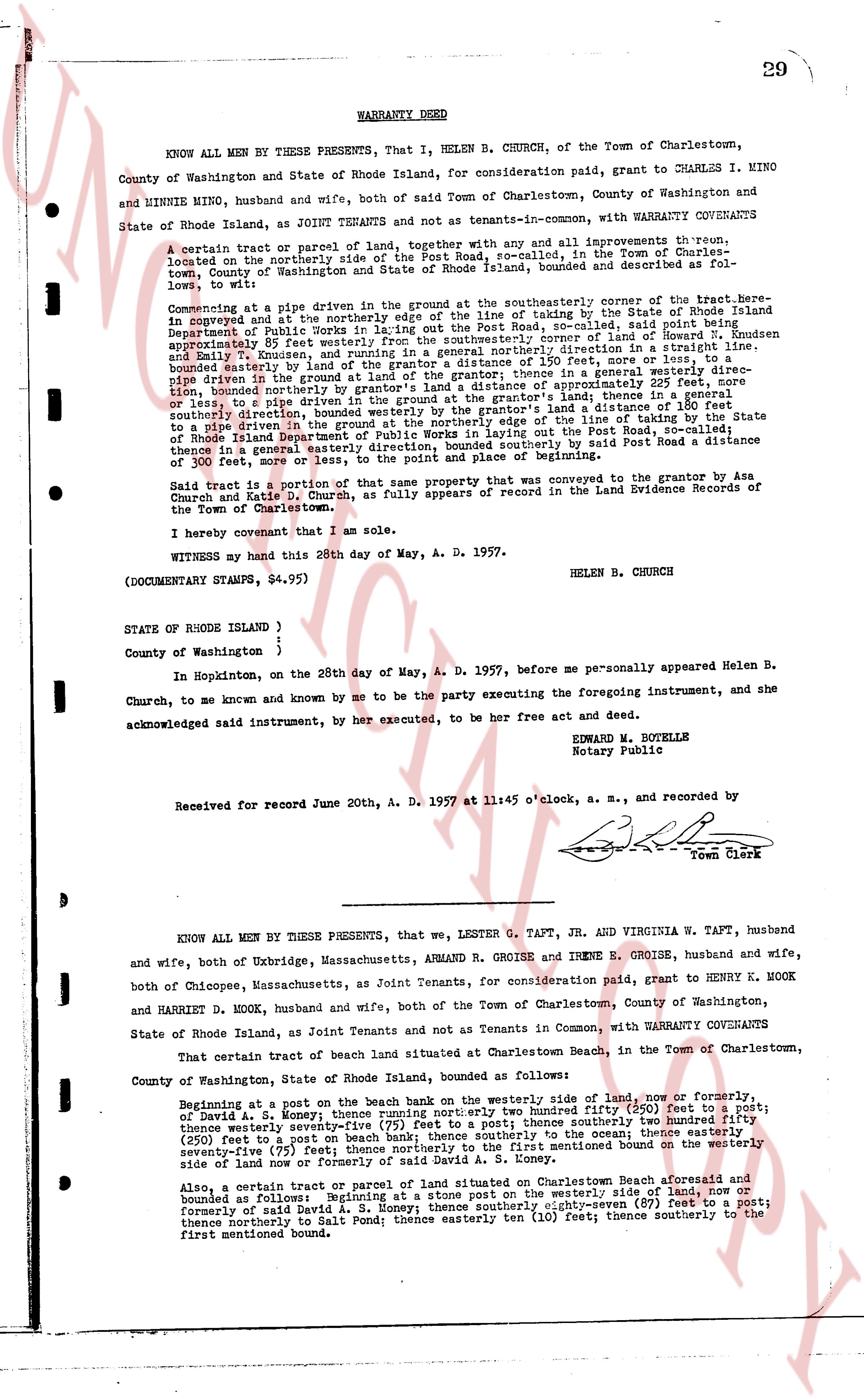
WARRANTY DEED
KNOW ALL MEN BY THESE PRESENTS, That I, HELEN B. CHURCH, of the Town of Charlestown, County of Washington and State of Rhode Island, for consideration paid, grant to CHARLES I. MINO and MINNIE MINO, husband and wife, both of said Town of Charlestown, County of Washington and State of Rhode Island, as JOINT TENANTS and not as tenants-in-common, with WARRANTY COVENANTS
A certain tract or parcel of land, together with any and all improvements thereon, located on the northerly side of the Post Road, so-called, in the Town of Charlestown, County of Washington and State of Rhode Island, bounded and described as follows:
Beginning at a pipe driven in the ground at the southeasterly corner of the target-here, bounded on the southeast by the northerly edge of the line of fence, as established by the State of Rhode Island Department of Public Works in the laying out of the Post Road, so-called, said point being approximately 85 feet westerly from the southeasterly corner of said fence; thence running in a straight line, said boundary extending northwesterly along the line of fence, bounded on the north by the land of [?] bounded easterly by the grantor's land of a distance 150 feet, or more or less, or to pipe driven in the ground; thence running from said pipe in a generally northerly direction, bounded northerly by grantor's land of a distance approximately 220 feet, more or less, to pipe driven in the ground; thence running from said pipe in a generally westerly direction, bounded southerly by the grantor's land of a distance 180 feet to pipe driven in the ground; thence running from said pipe in a generally southeasterly direction, bounded on the south by the line of fence, as established by the State of Rhode Island Department of Public Works in laying out the Post Road, so-called; thence in a general easterly direction, along the line of fence, returning to said Post Road a distance of 100 feet more or less, to the point of beginning and place of beginning.
Said tract is a portion of that some property that was conveyed to the grantor by Asa Church and Katie D. Church, as fully appears of record in the Land Evidence Records of the Town of Charlestown.
I hereby covenant that I am the sole.
WITNESS my hand this 28th day of May, A. D. 1957.
HELEN B. CHURCH
(DOCUMENTARY STAMPS, $4.95)
STATE OF RHODE ISLAND }
County of Washington }
In Hopkinton, on the 28th day of May, A. D. 1957, before me personally appeared Helen B. Church, to me known and by me to be the party executing the foregoing instrument, and she acknowledged said instrument, by her execution, to be her free act and deed.
EDWARD W. ROYETTE
Notary Public
Received for record June 20th, A. D. 1957 at 11:45 o'clock, a. m., and recorded by [signature]
Town Clerk
----
KNOW ALL MEN BY THESE PRESENTS, that we, LESTER G. TAFT, JR. AND VIRGINIA W. TAFT, husband and wife, both of Uxbridge, Massachusetts, ARMAND R. GROISE and IRENE E. GROISE, husband and wife, both of Chicopee, Massachusetts, as Joint Tenants, for consideration paid, grant to HENRY K. MOOK and HARRIET D. MOOK, husband and wife, both of the Town of Charlestown, County of Washington, State of Rhode Island, as Joint Tenants and not as Tenants in Common, with WARRANTY COVENANTS
That certain tract of beach land situated at Charlestown Beach, in the Town of Charlestown, County of Washington, State of Rhode Island, bounded as follows:
Beginning at a post on the beach bank on the westerly line of said land, now or formerly of David A. S. Komey; thence running southerly eighty-five (85) feet to a post; thence westerly twenty-five (25) feet to a post; thence southerly two hundred fifty (250) feet to a post; thence westerly twenty-five (25) feet to a post on beach bank; thence southerly two hundred fifty (250) feet to a post; thence easterly twenty-five (25) feet to a post; thence northerly on the first mentioned bound on the westerly seventy-five (75) feet to the point of beginning or formerly of said David A. S. Komey.
Also, a certain tract or parcel of land situated on Charlestown Beach aforesaid and bounded as follows: Beginning at a post on the westerly side of land, now or formerly of said David A. S. Komey; thence southerly eighty-seven (87) feet to a post; thence northerly to Salt Pond; thence easterly ten (10) feet; thence southerly to the first mentioned bound.
page 2 · read by Gemma vision
80
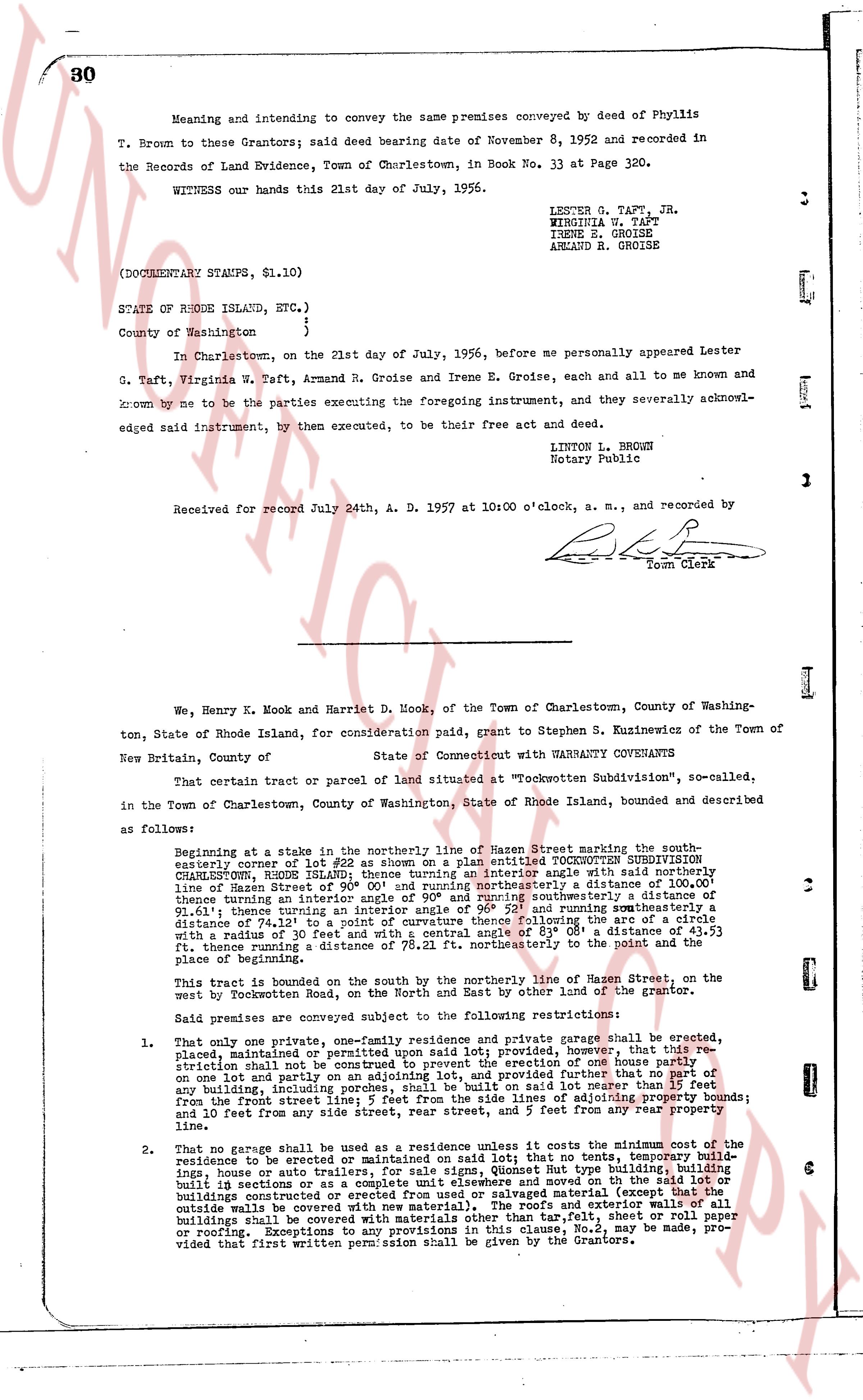
Meaning and intending to convey the same premises conveyed by deed of Phyllis T. Brown to these Grantors; said deed bearing date of November 8, 1952 and recorded in the Records of Land Evidence, Town of Charlestown, in Book No. 33 at Page 320.
WITNESS our hands this 21st day of July, 1956.
LESTER G. TAFT, JR.
VIRGINIA W. TAFT
IRENE E. GROISE
ARMAND R. GROISE
(DOCUMENTARY STAMPS, $1.10)
STATE OF RHODE ISLAND, ETC.)
County of Washington )
In Charlestown, on the 21st day of July, 1956, before me personally appeared Lester G. Taft, Virginia W. Taft, Armand R. Groise and Irene E. Groise, each and all to me known and acknowledged by me to be the parties executing the foregoing instrument, and they severally acknowledged said instrument, by then executed, to be their free act and deed.
LINTON L. BROWN
Notary Public
Received for record July 24th, A. D. 1957 at 10:00 o'clock, a. m., and recorded by
[Signature]
Town Clerk
----
We, Henry K. Mook and Harriet D. Mook, of the Town of Charlestown, County of Washington, State of Rhode Island, for consideration paid, grant to Stephen S. Kuzinewicz of the Town of New Britain, County of State of Connecticut with WARRANTY COVENANTS
That certain parcel or tract of land situated at "Tockwitten Subdivision", so-called, in the Town of Charlestown, County of Washington, State of Rhode Island, bounded and described as follows:
Beginning at a stake in the northerly line of Mason Street marking the southeasterly corner of lot #22 as shown on a Platted TOCKWITTEN SUBDIVISION CHARLESTOWN, RHODE ISLAND; thence turning an interior angle west with said northerly line of Mason Street of 90 degrees and running thence northerly a distance of 100.00 thence turning an interior angle of 90 degrees and running southeasterly a distance of 81.11 thence turning an interior angle of 90 degrees and running southeasterly a distance of 74.13 thence turning to a point of curvature thence following the arc of a circle with a radius of 30 feet to a point of tangency said arc being 89 deg. 0' 53" 1.53 ft. thence running a distance of 78.21 ft. northeasterly to the point and the place of beginning.
This tract is bounded on the south by the northerly line of Mason Street, on the west by Rocklanden Road, on the North and East by other land of the grantor.
Said premises are conveyed subject to the following restrictions:
1. That only one private, one-family residence and private garage shall be erected, placed, maintained or permitted upon said lot; provided, however, that this restriction shall not be deemed to prevent the erection of one barn or shed on one lot and partly on an adjoining lot and further, provided that no part of any building, including porches, steps, etc. shall be located in any manner what so ever lot from the front street line : 5 feet from the side lines : 5 feet from the side lines of adjoining property bounds; and 10 feet from any side street, rear street, and 5 feet from any rear property line.
2. That no garage shall be used as a residence or store; that no tent, temporary building, residence to be erected or maintained on said lot; that no signs, Quonset Hut type buildings, building built in sections or as a complete unit elsewhere and moved on to the lot, or any buildings constructed of corrugated iron, tin, concrete block and material (except that the outside walls be covered with new material), the roofs and exterior walls of all buildings shall be covered with fire proof material, such as slate, tile, sheet metal or roofing. Exceptions to any provisions in this clause, No.2, may be made; Provided that first written permission shall be given by the Grantors.
The page as recorded