The instrument's own words
page 1 · read by Gemma vision
18
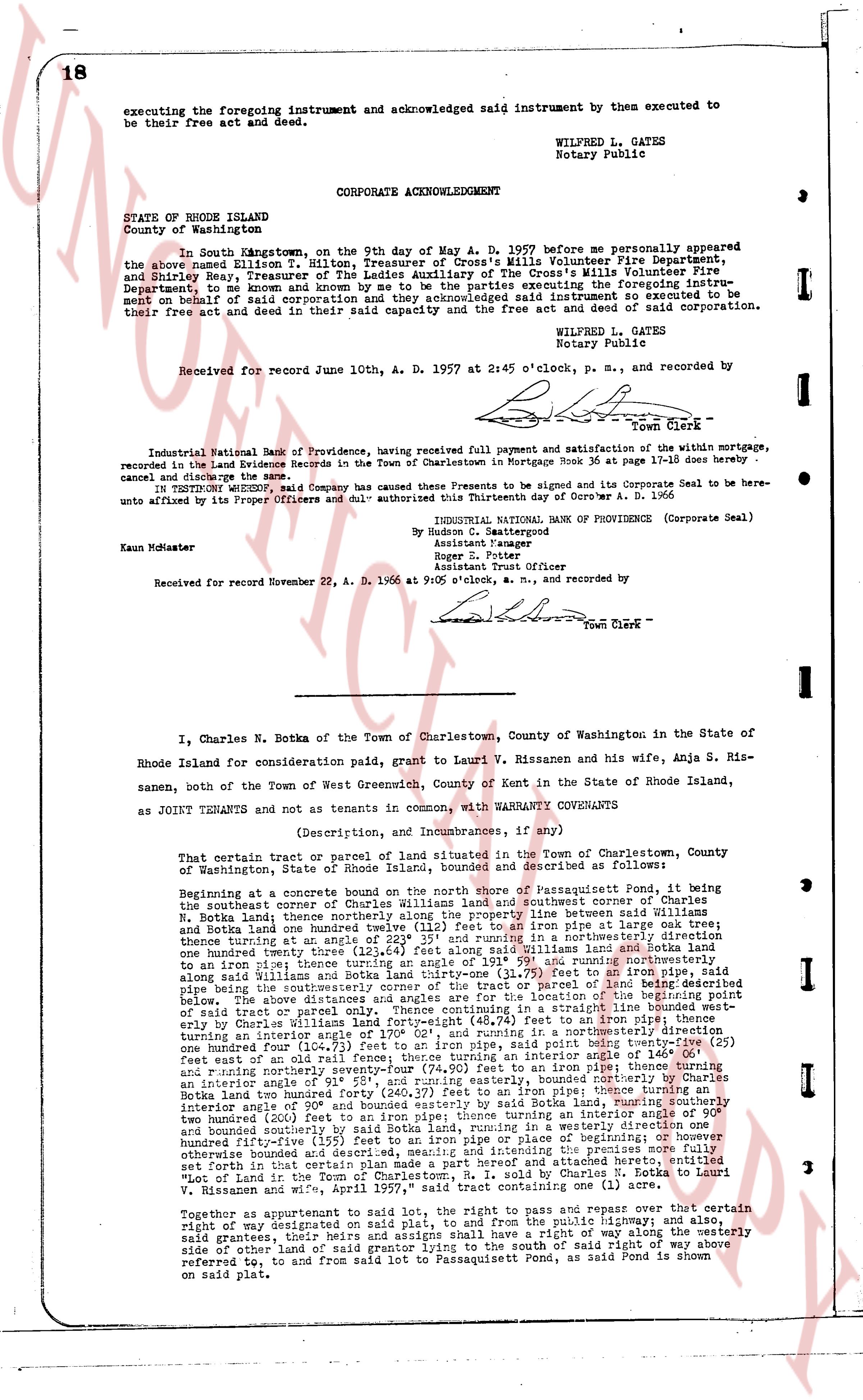
executing the foregoing instrument and acknowledged said instrument by them executed to be their free act and deed.
WILFRED L. GATES
Notary Public
CORPORATE ACKNOWLEDGMENT
STATE OF RHODE ISLAND
County of Washington
In South Kingstown, on the 9th day of May A. D. 1957 before me personally appeared the above named Hilton T. Milton, Treasurer of Crosses Mills Volunteer Fire Department, and Shirley Bay, Treasurer of The Ladies Auxiliary of the Crosses Mills Volunteer Fire Department, to me known and known to me to be the persons executing the foregoing instrument on behalf of said corporation and they acknowledged said instrument so executed to be their free act and deed in their said capacity and the free act and deed of said corporation.
WILFRED L. GATES
Notary Public
Received for record June 10th, A. D. 1957 at 2:45 o'clock, p. m., and recorded by
[Signature]
Town Clerk
----
Industrial National Bank of Providence, having received full payment and satisfaction of the within mortgage, recorded in the Land Evidence Records in the Town of Charlestown in Mortgage Book 36 at page 17-18 does hereby cancel and discharge the same.
IN WITNESS WHEREOF, said Company has caused the Presents to be signed and its Corporate Seal to be hereunto affixed by its Proper Officers and duly authorized this Thirtieth day of October A. D. 1956
(Corporate Seal)
INDUSTRIAL NATIONAL BANK OF PROVIDENCE
By [Signature]
Assistant Manager
By [Signature]
Assistant Trust Officer
Kaun McMaster
Received for record November 22, A. D. 1956 at 9:05 o'clock, a. m., and recorded by
[Signature]
Town Clerk
----
I, Charles N. Botka of the Town of Charlestown, County of Washington in the State of Rhode Island for Consideration paid, grant to Lauri V. Rissanen and his wife, Anja S. Rissanen, both of the Town of West Greenwich, County of Kent in the State of Rhode Island, as JOINT TENANTS and not as tenants in common, with WARRANTY COVENANTS
(Description, and Incumbrances, if any)
That certain tract or parcel of land situated in the town of Charlestown, County of Washington, state of Rhode Island, bounded and described as follows:
Beginning at a concrete boundary marker at the northwesterly corner of Passaquisset Pond, it being the southeasterly corner of Charles Williams land and southeasterly corner of Charles N. Botka land; thence northerly along the property line between Williams and Botka and Botka land one hundred ninety-four (194) feet to an iron pipe at large oak tree; thence turning at an angle of 22.5° 233 and running northerly in a straight line along Botka land one hundred ninety-four (194) feet to an iron pipe; thence turning at an angle of 191° 59' and running northwesterly along said Williams land one hundred twenty-three (123) feet to an iron pipe; thence turning at an iron pipe 321 turning the southeasterly corner of the tract or parcel of land being described below, then a line along the shore of Passaquisset Pond to the northwesterly corner of said tract or parcel only. Thence continuing in a straight line bounded west-northwesterly one hundred four (104) feet to an iron pipe; thence turning at an angle of turning an interior angle of 170° 02' and running in a northwesterly direction one hundred four (104) feet to an iron pipe; thence turning at an interior angle of 140° 15' and running east wall of an old rail fence; thence turning an interior angle of 146° 0' and running northerly one hundred forty-seven (147) feet to an iron pipe that forms an interior angle of 180° 0' and running northerly 58' 1", and ending southeasterly bounded by Charles Botka land two hundred forty (240.27) feet to an iron pipe; thence turning at an interior angle of 200° 00' and running southeasterly by said Botka land, running southeasterly one hundred twenty (200) feet to an iron pipe; thence turning an interior angle of 130° 00' and running southeasterly one hundred twenty (200) feet to an iron pipe; thence turning an interior angle of 130° 00' and running southeasterly in a westerly direction one hundred fifty-five (155) feet to an iron pipe or pipe of beginning or however otherwise bounded and described, the whole of said tract being the property set forth in that certain plan made a part and referenced attached hereto, entitled "Mentioned one hundred (1) acre in the Town of Charlestown by Council" dated 1957 between V. Rissanen and wife, "page 197," said tract containing one acre (1) to an angle.
Together as appurtenant to said lot, the right to pass and repass over that certain right of way designated as "Private Right of Way" on the plat map, 함께 and also, said grantees, four heirs and assigns shall have a right of way along the westerly side of other land of said grantor lying to the south of said right of way above referred to, and from said lot to Passaquisset Pond, as said Pond is shown referring to, and from said lot to Passaquisset Pond, as said Pond is shown on said plat.
page 2 · read by Gemma vision
19
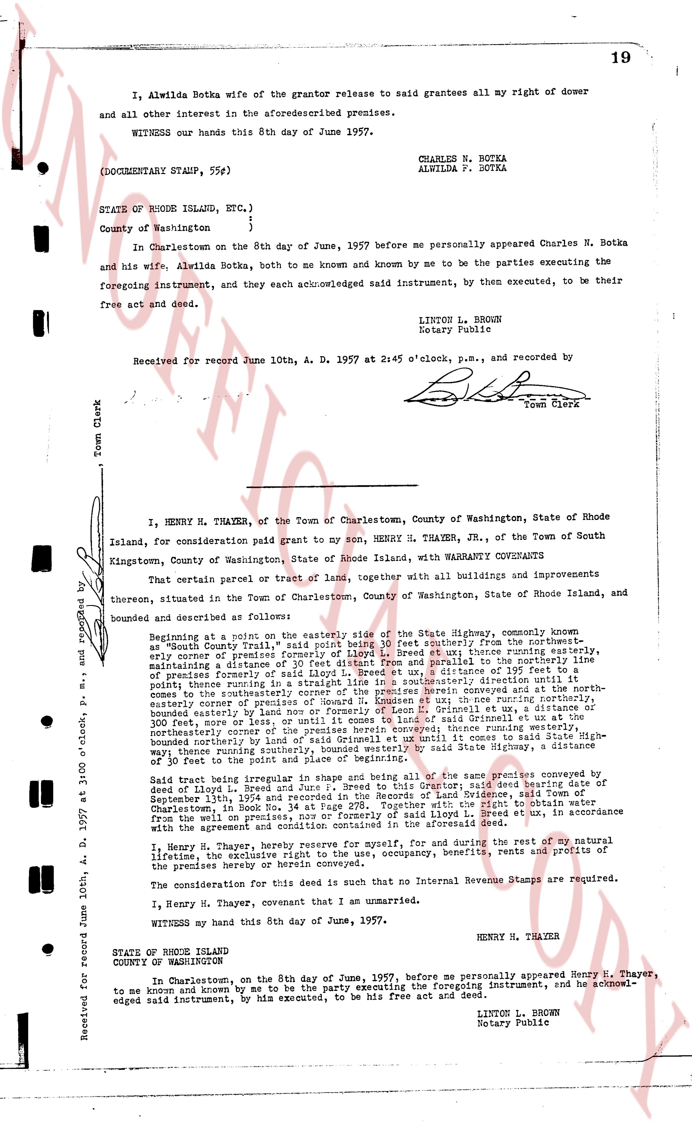
I, Alwilda Botka wife of the grantor release to said grantees all my right of dower and all other interest in the aforesaid premises.
WITNESS our hands this 8th day of June 1957.
CHARLES N. BOTKA
ALWILDA F. BOTKA
(DOCUMENTARY STAMP, 55¢)
STATE OF RHODE ISLAND, ETC.)
County of Washington }
) ss.
In Charlestown on the 8th day of June, 1957 before me personally appeared Charles N. Botka and his wife, Alwilda Botka, both to me known and by me known to be the parties executing the foregoing instrument, and they each acknowledged said instrument, by them executed, to be their free act and deed.
LINTON L. BROWN
Notary Public
Received for record June 10th, A. D. 1957 at 2:45 o'clock, p.m., and recorded by
[Signature]
Town Clerk
----
Received for record June 10th, A. D. 1957 at 3:00 o'clock, p.m. and recorded by
I, HENRY H. THAYER, of the Town of Charlestown, County of Washington, State of Rhode Island, for consideration paid grant to my son, HENRY H. THAYER, JR., of the Town of South Kingstown, County of Washington, State of Rhode Island, with WARRANTY COVENANTS
That certain parcel or tract of land, together with all buildings and improvements thereon, situated in the Town of Charlestown, County of Washington, State of Rhode Island, and bounded and described as follows:
Beginning at a point on or about the easterly side of the State Highway, commonly known as "South County Trail" said point being 100 feet southerly; from the northeast-easterly corner of Lloyd L. Breed et ux; thence running easterly, only some distance to the easterly line of the premises conveyed to said Breed et ux, in the maintaining a distance of 30 feet distant from the easterly line of said premises to the northeast corner of the premises conveyed to said Breed et ux, a distance of 195 feet to a point; thence running in a straight line in a southeasterly direction to the northeast corner of the premises conveyed to said Breed et ux, a distance of 100 feet to a point; thence running northerly, along the easterly line of the premises conveyed to said Breed et ux, to the northeast-easterly corner of premises of Howard H. Rissanen et ux; thence running northerly, bounded easterly by land of said Rissanen et ux, a distance of 100 feet to a point; thence running northerly, bounded easterly by land of said Rissanen et ux, a distance of 300 feet, or more, or less, or until it comes to land of said Grinnell et ux at the northeast corner of the premises conveyed to said Grinnell et ux, a distance of 300 feet, bounded northerly by land of said Grinnell et ux and until it comes to said State Highway; thence running southerly, along said State Highway, a distance of 300 feet, bounded westerly by land of said Grinnell et ux and until it comes to said State Highway; thence running southerly, along said State Highway, a distance of 100 feet to the point of beginning.
Said tract being regular in shape and being a part of the same tract of land conveyed to said Lloyd L. Breed and Jose f. L. Breed, by a certain indenture, said deed bearing date of September 1st, 1932 and recorded in the Records of Land Evidence, said Town of Charlestown, in Book No. 34 at Page 278. Together with the right to obtain water from the well located on the premises conveyed to Lloyd L. Breed et ux, in accordance with the agreement and condition contained in the aforesaid deed.
I, Henry H. Thayer, reserve for myself, for during and for the rest of my natural lifetime, the exclusive right of possession, occupancy, benefits, rents and profits of the premises hereby herein conveyed.
The consideration for this deed is such that no Internal Revenue Stamps are required.
I, Henry H. Thayer, covenant that I am unmarried.
WITNESS my hand this 8th day of June, 1957.
HENRY H. THAYER
STATE OF RHODE ISLAND
COUNTY OF WASHINGTON
In Charlestown, on the 8th day of June, 1957, before me personally appeared Henry H. Thayer, to me known and known by me to be the party executing the foregoing instrument, and he acknowledged said instrument, by him executed, to be his free act and deed.
LINTON L. BROWN
Notary Public
The page as recorded