The instrument's own words
page 1 · read by Gemma vision
626
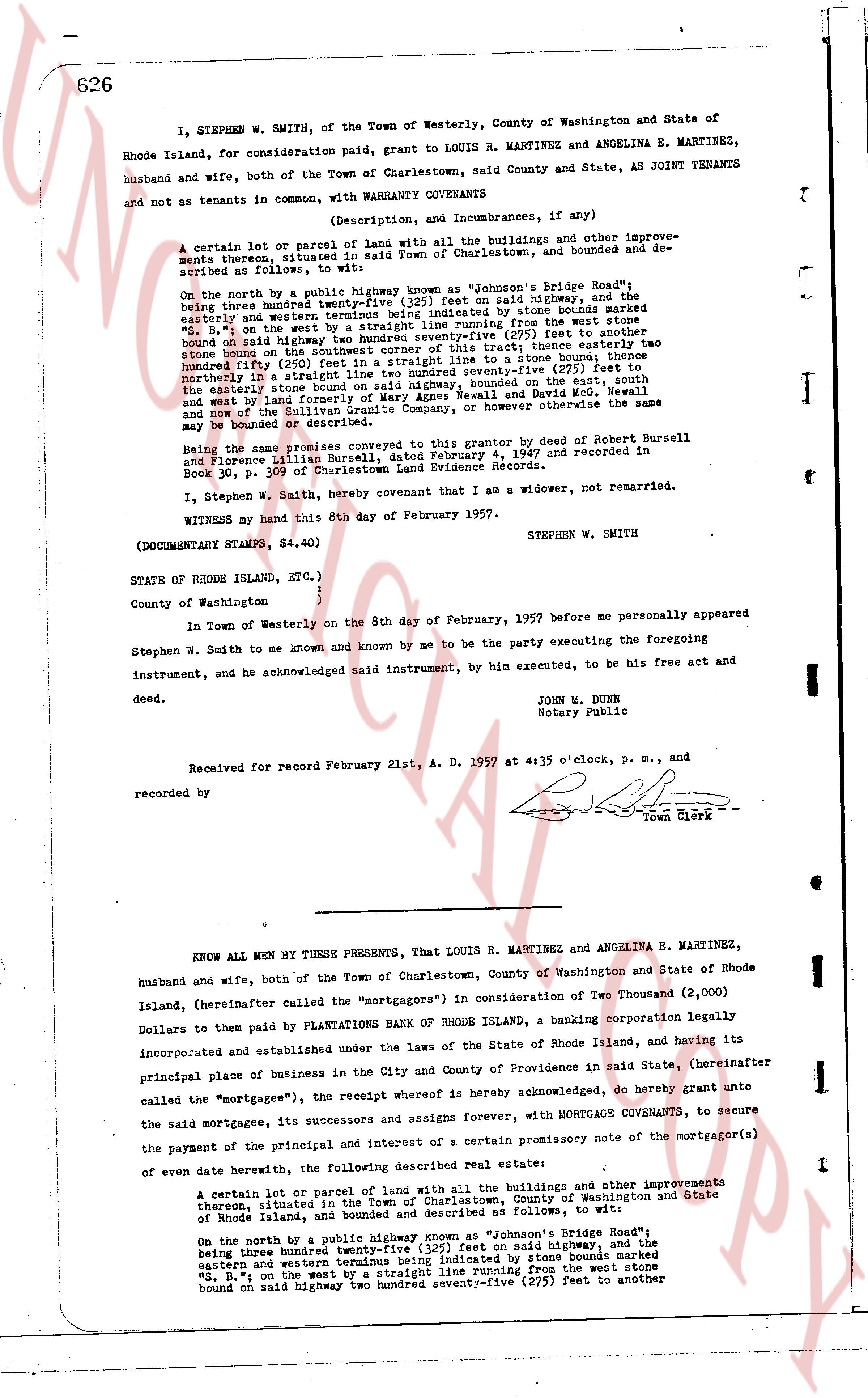
I, STEPHEN W. SMITH, of the Town of Westerly, County of Washington and State of Rhode Island, for consideration paid, grant to LOUIS R. MARTINEZ and ANGELINA E. MARTINEZ, husband and wife, both of the Town of Charlestown, said County and State, AS JOINT TENANTS and not as tenants in common, with WARRANTY CONVEYANCE
(Description, and Incumbrances, if any)
A certain lot or parcel of land with all the buildings and other improvements developments thereon, situated in said Town of Charlestown, and bounded and described as follows, to wit:
On the north by a public highway known as "Johnson's Bridge Road" the being three hundred twenty-five (325) feet on said highway, and the easterly and western terminals thereof determined by stone bounds marked "S. B." and "E. B." on the west by a straight line running from the west stone bound on said highway two hundred seventy-five (275) feet to another stone bound on the straight line, thence easterly two hundred seventy-five (275) feet in a straight line to a stone bound terminal northly in a straight line two hundred seventy-five (275) feet to the easterly stone bound on said highway bounded, on the east, south and west, now and by land formerly of the Sullivan Granite Company, or however otherwise the same may be bounded or described.
Being the same premises conveyed to this grantor by deed of Robert Bursell and Florence Lillian Bursell, dated February 4, 1947 and recorded in Book 30, p. 309 of Charlestown Land Evidence Records.
I, Stephen W. Smith, hereby covenant that I am a widower, not remarried.
WITNESS my hand this 8th day of February 1957.
STEPHEN W. SMITH
(DOCUMENTARY STAMPS, $4.40)
STATE OF RHODE ISLAND, ETC.)
County of Washington {
In Town of Westerly on the 8th day of February, 1957 before me personally appeared Stephen W. Smith to me known and known by me to be the party executing the foregoing instrument, and he acknowledged said instrument, by his executed, to be his free act and deed.
JOHN W. DUNN
Notary Public
Received for record February 21st, A. D. 1957 at 4:35 o'clock, P. M., and recorded by [?]
Town Clerk
----
KNOW ALL MEN BY THESE PRESENTS, That LOUIS R. MARTINEZ and ANGELINA E. MARTINEZ, husband and wife, both of the Town of Charlestown, County of Washington and State of Rhode Island, (hereinafter called the "mortgagors") in consideration of Two Thousand (2,000) Dollars to them paid by PLANTATIONS BANK OF RHODE ISLAND, a banking corporation legally incorporated and established under the laws of the State of Rhode Island, and having its principal place of business in the City and County of Providence in said State, (hereinafter called the "mortgagee"), the receipt whereof is hereby acknowledged, do hereby grant unto the said mortgagees, its successors and assigns forever, with MORTGAGE COVENANTS, to secure the payment of the principal and interest of a certain promissory note of the mortgagor(s) of even date herewith, the following described real estate:
A certain lot or parcel of land with all the buildings and other improvements thereon situated in the Town of Charlestown, County of Washington and State of Rhode Island, and bounded and described as follows, to wit:
On the north by a public highway known as "Johnson's Bridge Road" the being three hundred twenty-five (325) feet on said highway, and the eastern and western terminals thereof determined by stone bounds marked "S. B." and "E. B." on the west by a straight line running from the west stone bound on said highway two hundred seventy-five (275) feet to another
page 2 · read by Gemma vision
627
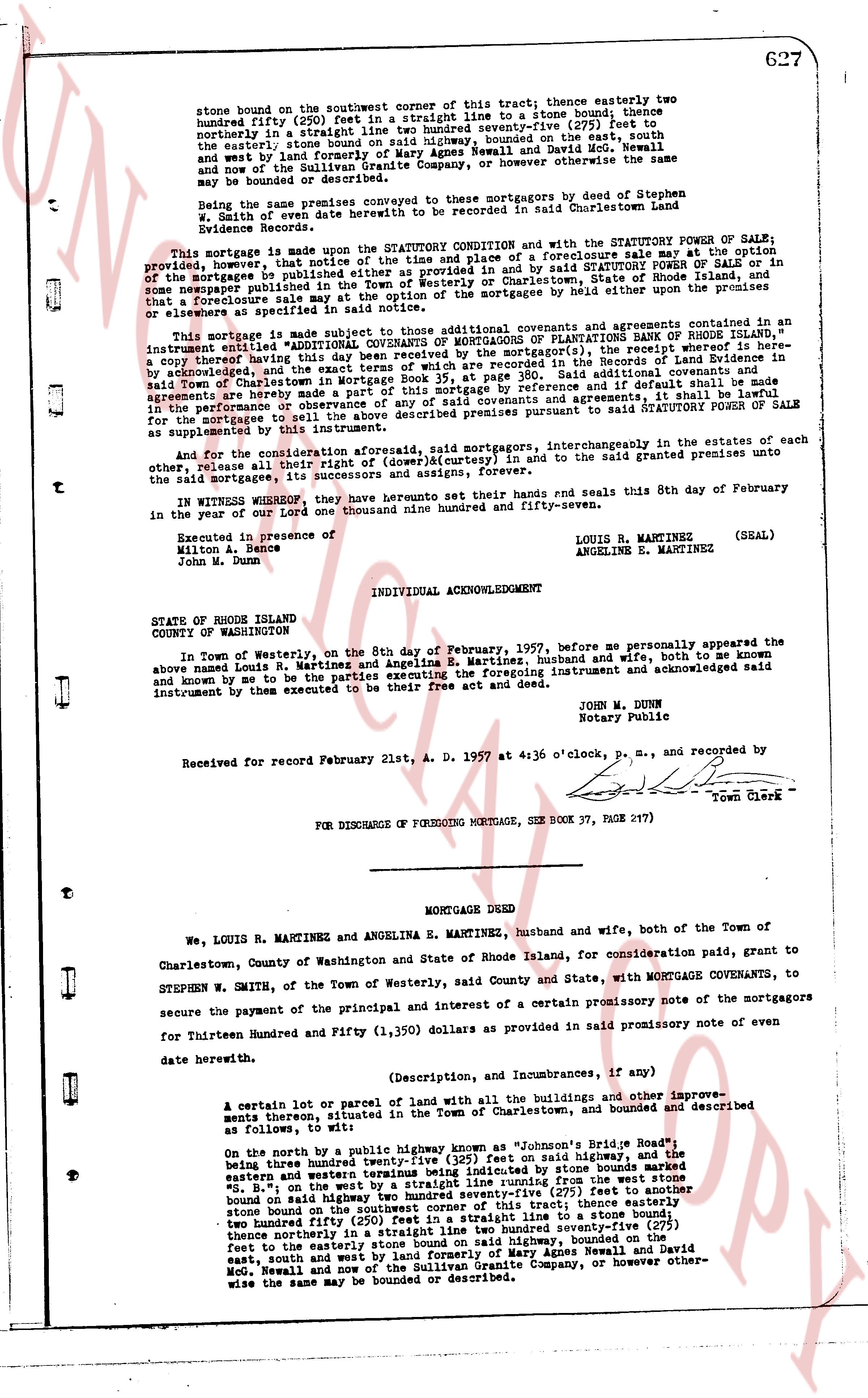
stone bound on the southwest corner of this tract thence easterly two hundred fifty (250) feet in a straight line to a stone bound; thence northerly in a straight line one hundred twenty-seven (127) feet to the easterly stone bound on said highway, bounded on the east, south and west land formerly of Mary Agnes Newall and David McG. Newall and now of the Sullivan Granite Company, or however otherwise the same may be bounded or described.
Being the same premises conveyed to mortgagors by deed of Stephen B. White dated 6th June 1956 hereinto to be recorded in said Charlestown Land Evidence Records.
This mortgage is made upon the STATUTORY CONDITION and with the STATUTORY POWER OF SALE provided, however, that notice of the time and place of a foreclosure sale may at the option provided, be given, however, that notice of the time and place of a foreclosure sale may at the option provided, be given by the mortgagee by publishing a notice of said STATUTORY POWER OF SALE or in some newspaper published in the Town of Charlestown, or State of Rhode Island, and notice that a foreclosure sale may at the option of the mortgagee be held either upon the premises or elsewhere as specified in said notice.
This mortgage is also made subject to those additional covenants and agreements contained in an instrument entitled "ADDITIONAL COVENANTS OF MORTGAGEES OF PLANTATIONS BANK OF RHODE ISLAND," an expert copy thereof having been delivered to the mortgagors, the receipt whereof is here acknowledged, and the exact terms of which are recorded in the Records of Land Evidence in said Town of Charlestown in mortgage of this mortgage by reference and if default shall be made in any of the covenants or agreements of this mortgage by reference and if default shall be made in the performance or observance of any of said covenants and agreements the mortgagee may at its option foreclose the premises hereby mortgaged pursuant to said STATUTORY POWER OF SALE as supplemented by this instrument.
And for and consideration aforesaid, said mortgagors, interchangeably in the estates of each other and their heirs and assigns (convoyed/curtesy) in and to the said grant premises unite to the said mortgagee, its successors and assigns, to convey.
IN WITNESS WHEREOF, they have hereunto set their hands and seals this 8th day of February in the year of our Lord one thousand nine hundred and fifty-seven.
Executed in presence of
411on A. Prince
John M. Dunn
LOUIS R. MARTINEZ (SEAL)
ANGELINE E. MARTINEZ
INDIVIDUAL ACKNOWLEDGEMENT
STATE OF RHODE ISLAND
COUNTY OF WASHINGTON
In Town of Westerly, on the 8th day of February, 1957, before me personally appeared the above named Louis R. Martinez and Angelina E. Martinez, husband and wife, both to me known both to me known by me to be the parties executing the foregoing instrument and acknowledged said instrument by them executed to be their free act and deed.
JOHN M. DUNN
Notary Public
Received for record February 21st, A. D. 1957 at 4:36 o'clock, P. M., and recorded by
[signature] Town Clerk
FOR DISCHARGE OF FOREGOING MORTGAGE, SEE BOOK 37, PAGE 217
----
MORTGAGE DEED
We, LOUIS R. MARTINEZ and ANGELINA E. MARTINEZ, husband and wife, both of the Town of Charlestown, County of Washington and State of Rhode Island, for consideration paid, grant to STEPHEN W. SMITH, of the Town of Westerly, said County and State, with MORTGAGE COVENANTS, to secure the payment of the principal and interest of a certain promissory note of the mortgagors for Thirteen Hundred and Fifty (1,350) dollars as provided in said promissory note of even date herewith.
(Description, and Incumbrances, if any)
A certain lot or parcel of land with all the buildings and other improvements thereon situated in the Town of Charlestown, and bounded and described as follows, to wit:
On the north by a public highway known as "Johnson's Rhode Island Road," being three hundred twenty one and 13/100 feet on said highway, and the easterly and western lines being indicated by stone bounds marked "S. B." on the west by a straight line running from the west stone bound on said highway to a stone bound one hundred twenty-seven (127) feet to another stone bound on the southwest corner of this tract; thence easterly two hundred fifty (250) feet in a straight line to a stone bound; thence northerly in a straight line two hundred twenty-seven (227) feet to the easterly stone bound on said highway, bounded on the east, south and west land formerly of Mary Agnes Newall and David McG. Newall and now of the Sullivan Granite Company, or however otherwise wise the same may be bounded or described.
The page as recorded