The instrument's own words
page 1 · read by Gemma vision
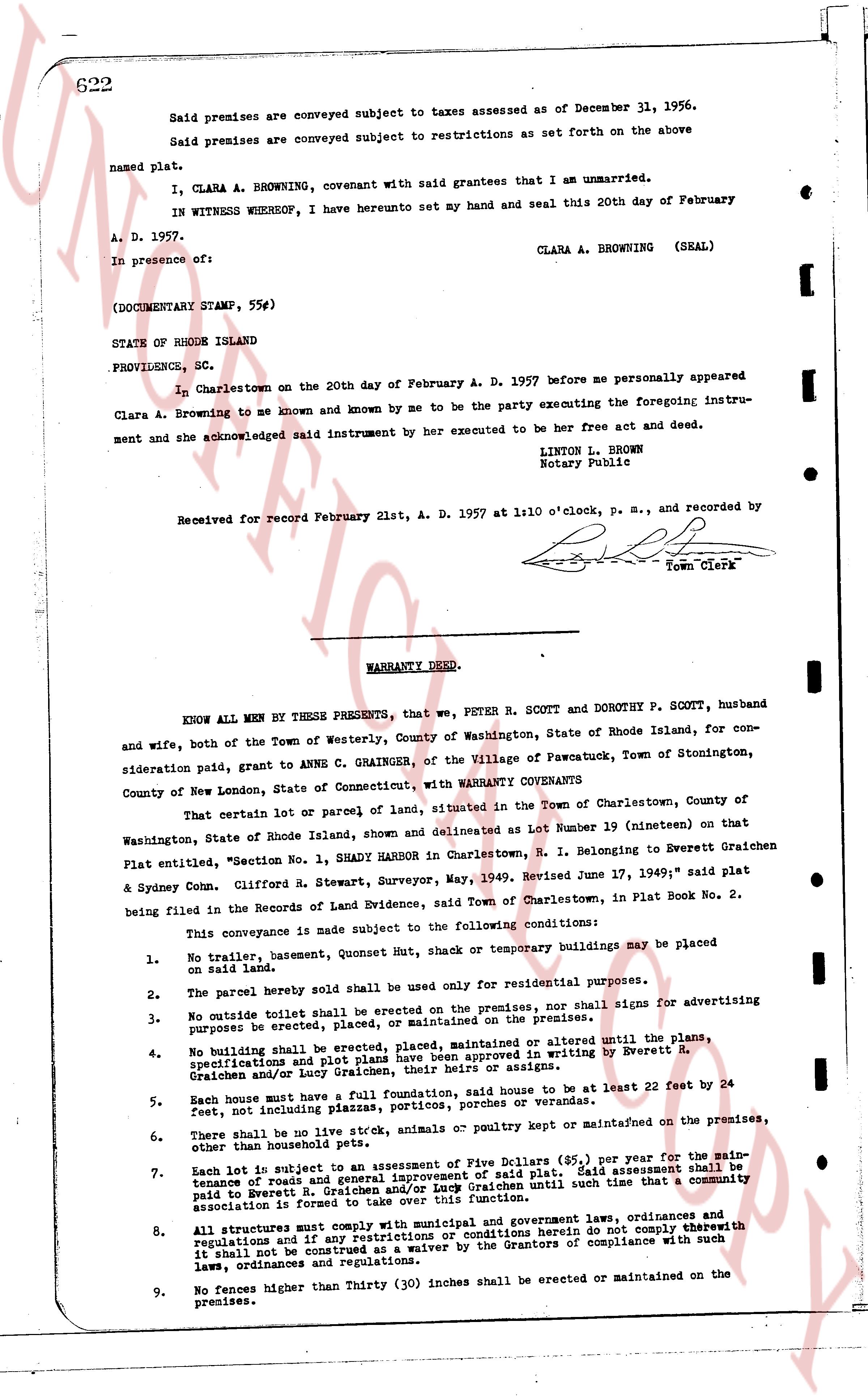
622
Said premises are conveyed subject to taxes assessed as of December 31, 1956.
Said premises are conveyed subject to restrictions as set forth on the above
named plat.
I, CLARA A. BROWNING, covenant with said grantees that I am unmarried.
IN WITNESS WHEREOF, I have hereunto set my hand and seal this 20th day of February
A. D. 1957.
CLARA A. BROWNING (SEAL)
In presence of:
[?]
[?]
(DOCUMENTARY STAMP, 55¢)
STATE OF RHODE ISLAND
PROVIDENCE, SC.
In Charlestown on the 20th day of February A. D. 1957 before me personally appeared
Clara A. Browning to me known and known by me to be the party executing the foregoing instrument and acknowledged said instrument by her executed to be her free act and deed.
LINTON L. BROWN
Notary Public
Received for record February 21st, A. D. 1957 at 1:10 o'clock, p. m., and recorded by
[Signature]
Town Clerk
----
WARRANTY DEED.
KNOW ALL MEN BY THESE PRESENTS, that we, PETER R. SCOTT and DOROTHY P. SCOTT, husband and wife, both of the Town of Westerly, County of Washington, State of Rhode Island, for consideration paid, grant to ANNE C. GRAINGER, of the Village of Pawcatuck, Town of Stonington, County of New London, State of Connecticut, with WARRANTY COVENANTS
That certain lot or parcel of land, situated in the Town of Charlestown, County of Washington, State of Rhode Island, shown and delineated as Lot Number 19 (nineteen) on that Plat entitled, "Section one, 1, SHADY HARBOR in Charlestown, R. I. Belonging to Everett Graichen & Sydney Conn. Clifford R. Stewart, Surveyor, May, 1949. Revised June 17, 1949;" said plat being filed in the Records of Land Evidence, said Town of Charlestown, in Plat Book No. 2.
This conveyance is made subject to the following conditions:
1. No trailer, basemen, Quonset Hut, shack or temporary buildings may be placed on said land.
2. The parcel hereby sold shall be used only for residential purposes.
3. No outside toilet shall be erected on the premises, nor shall signs for advertising purposes be erected, placed, or maintained on the premises.
4. No building shall be erected or platten, placed maintained or altered until the plans, specifications and platting have been approved in writing by Everett R. Graichen and/or Lucy Graichen, their heirs or assigns.
5. Each house must have a soll foundation, said house to be at least twenty ft by 22 ft, feet, not including porches, patios, porches, or terraces.
6. There shall be no live stock, animals or poultry kept or maintained on the premises, other than household pets.
7. Each lot is subject to an assessment of Five Dollars ($5.) per year for the maintenance of roads and general improvement of said plat. Said assessment shall be paid to Everett R. and/or Lucy Graichen until such time that a community association is formed to take over this function.
8. All structures must comply with municipal and government laws, ordinances and regulations and if any of the buildings or restrictions herein do not comply therewith it shall not be construed as a waiver by the Grantors of compliance with such laws, ordinances and regulations.
9. No fences higher than Thirty (30) inches shall be erected or maintained on the premises.
page 2 · read by Gemma vision
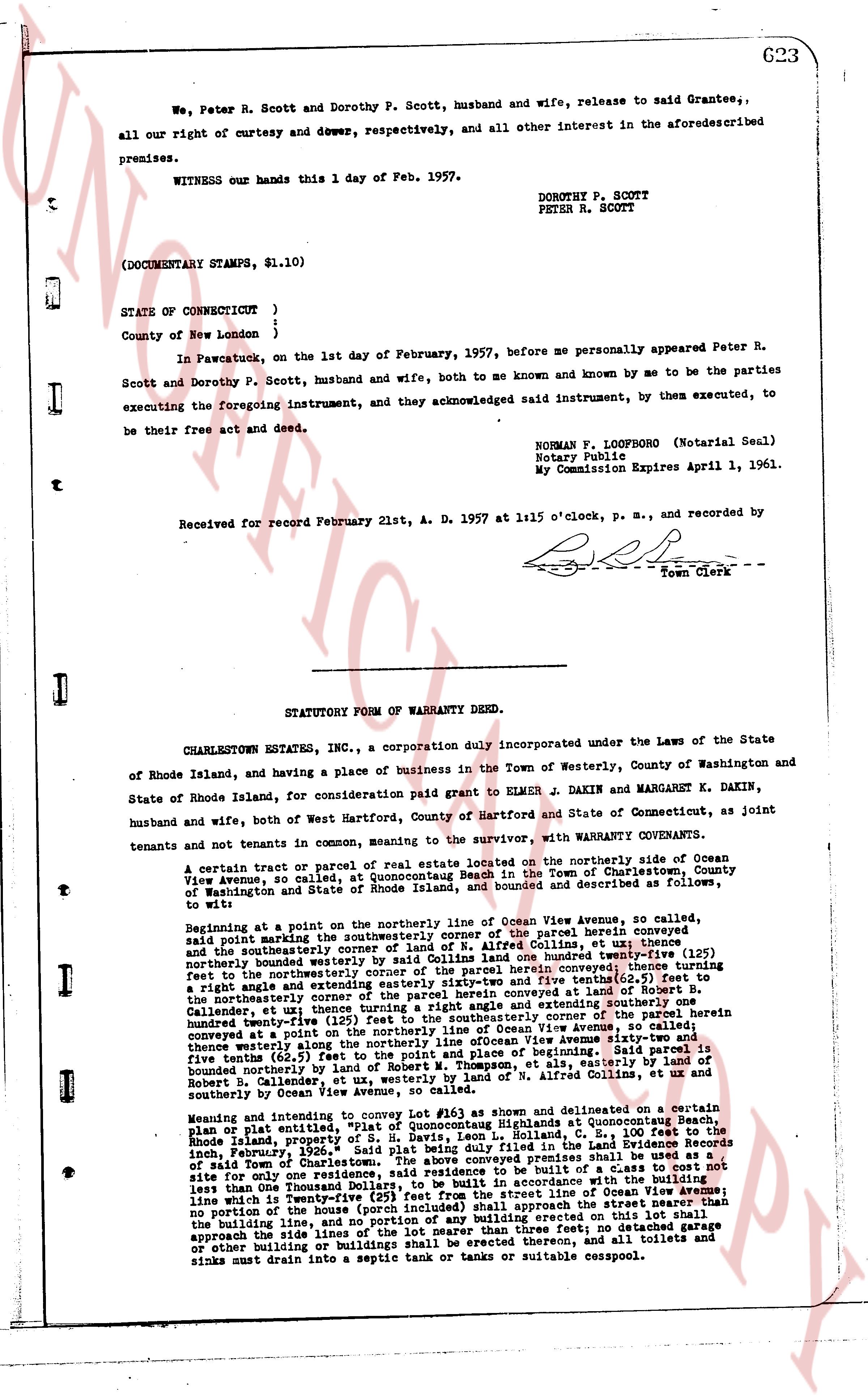
623
We, Peter R. Scott and Dorothy P. Scott, husband and wife, release to said Grantees, all our right of curtesy and dower, respectively, and all other interest in the aforesaid premises.
WITNESS our hands this 1 day of Feb. 1957.
DOROTHY P. SCOTT
PETER R. SCOTT
(DOCUMENTARY STAMPS, $1.10)
STATE OF CONNECTICUT }
}
County of New London }
In Pawcatuck, on the 1st day of February, 1957, before me personally appeared Peter R. Scott and Dorothy P. Scott, husband and wife, both to me known and by me to be the parties executing the foregoing instrument, and they acknowledged said instrument, by them executed, to be their free act and deed.
NORMAN F. LOOFBORO (Notarial Seal)
Notary Public
My Commission Expires April 1, 1961.
Received for record February 21st, A. D. 1957 at 1:15 o'clock, p. m., and recorded by [signature]
Town Clerk
----
STATUTORY FORM OF WARRANTY DEED.
CHARLESTOWN ESTATES, INC., a corporation duly incorporated under the Laws of the State of Rhode Island, and having a place of business in the Town of Westerly, County of Washington and State of Rhode Island, for consideration paid grant to ELMER J. DAKIN and MARGARET K. DAKIN, husband and wife, both of West Hartford, County of Hartford and State of Connecticut, as joint tenants and not tenants in common, meaning to the survivor, with WARRANTY COVENANTS.
To wit:
A certain tract or parcel of real estate located on the northerly side of Ocean View Avenue, so called, at Quonocutaug Beach, Town of Charlestown, County of Washington and State of Rhode Island, and bounded and described as follows, to wit:
Beginning at a point on the northerly line of Ocean View Avenue, so called, said point being the southeasterly corner of the parcel herein conveyed and the northeasterly corner of a parcel owned by Allred Collins, et ux; thence one (1) foot northerly bounded westerly by said Collins land one hundred twenty-one (121) feet northerly bounded westerly by said Collins land one hundred twenty-one (121) feet northerly bounded westerly by said Collins land one hundred twenty-one (121) feet northerly bounded westerly by said Collins land one hundred twenty-one (121) feet northerly bounded westerly by said Collins land one hundred twenty-one (121) feet northerly bounded westerly by said Collins land one hundred twenty-one (121) feet northerly bounded westerly by said Collins land one hundred twenty-one (121) feet northerly bounded westerly by said Collins land one hundred twenty-one (121) feet northerly bounded westerly by said Collins land one hundred twenty-one (121) feet northerly bounded westerly by said Collins land one hundred twenty-one (121) feet northerly bounded westerly by said Collins land one hundred twenty-one (121) feet northerly bounded westerly by said Collins land one hundred twenty-one (121) feet northerly bounded westerly by said Collins land one hundred twenty-one (121) feet northerly bounded westerly by said Collins land one hundred twenty-one (121) feet northerly bounded westerly by said Collins land one hundred twenty-one (121) feet northerly bounded westerly by said Collins land one hundred twenty-one (121) feet northerly bounded westerly by said Collins land one hundred twenty-one (121) feet northerly bounded westerly by said Collins land one hundred twenty-one (121) feet northerly bounded westerly by said Collins land one hundred twenty-one (121) feet northerly bounded westerly by said Collins land one hundred twenty-one (121) feet northerly bounded westerly by said Collins land one hundred twenty-one (121) feet northerly bounded westerly by said Collins land one hundred twenty-one (121) feet northerly bounded westerly by said Collins land one hundred twenty-one (121) feet northerly bounded westerly by said Collins land one hundred twenty-one (121) feet northerly bounded westerly by said Collins land one hundred twenty-one (121) feet northerly bounded westerly by said Collins land one hundred twenty-one (121) feet northerly bounded westerly by said Collins land one hundred twenty-one (121) feet northerly bounded westerly by said Collins land one hundred twenty-one (121) feet northerly bounded westerly by said Collins land one hundred twenty-one (121) feet northerly bounded westerly by said Collins land one hundred twenty-one (121) feet northerly bounded westerly by said Collins land one hundred twenty-one (121) feet northerly bounded westerly by said Collins land one hundred twenty-one (121) feet northerly bounded westerly by said Collins land one hundred twenty-one (121) feet northerly bounded westerly by said Collins land one hundred twenty-one (121) feet northerly bounded westerly by said Collins land one hundred twenty-one (121) feet northerly bounded westerly by said Collins land one hundred twenty-one (121) feet northerly bounded westerly by said Collins land one hundred twenty-one (121) feet northerly bounded westerly by said Collins land one hundred twenty-one (121) feet northerly bounded westerly by said Collins land one hundred twenty-one (121) feet northerly bounded westerly by said Collins land one hundred twenty-one (121) feet northerly bounded westerly by said Collins land one hundred twenty-one (121) feet northerly bounded westerly by said Collins land one hundred twenty-one (121) feet northerly bounded westerly by said Collins land one hundred twenty-one (121) feet northerly bounded westerly by said Collins land one hundred twenty-one (121) feet northerly bounded westerly by said Collins land one hundred twenty-one (121) feet northerly bounded westerly by said Collins land one hundred twenty-one (121) feet northerly bounded westerly by said Collins land one hundred twenty-one (121) feet northerly bounded westerly by said Collins land one hundred twenty-one (121) feet northerly bounded westerly by said Collins land one hundred twenty-one (121) feet northerly bounded westerly by said Collins land one hundred twenty-one (121) feet northerly bounded westerly by said Collins land one hundred twenty-one (121) feet northerly bounded westerly by said Collins land one hundred twenty-one (121) feet northerly bounded westerly by said Collins land one hundred twenty-one (121) feet northerly bounded westerly by said Collins land one hundred twenty-one (121) feet northerly bounded westerly by said Collins land one hundred twenty-one (121) feet northerly bounded westerly by said Collins land one hundred twenty-one (121) feet northerly bounded westerly by said Collins land one hundred twenty-one (121) feet northerly bounded westerly by said Collins land one hundred twenty-one (121) feet northerly bounded westerly by said Collins land one hundred twenty-one (121) feet northerly bounded westerly by said Collins land one hundred twenty-one (121) feet northerly bounded westerly by said Collins land one hundred twenty-one (121) feet northerly bounded westerly by said Collins land one hundred twenty-one (121) feet northerly bounded westerly by said Collins land one hundred twenty-one (121) feet northerly bounded westerly by said Collins land one hundred twenty-one (121) feet northerly bounded westerly by said Collins land one hundred twenty-one (121) feet northerly bounded westerly by said Collins land one hundred twenty-one (121) feet northerly bounded westerly by said Collins land one hundred twenty-one (121) feet northerly bounded westerly by said Collins land one hundred twenty-one (121) feet northerly bounded westerly by said Collins land one hundred twenty-one (121) feet northerly bounded westerly by said Collins land one hundred twenty-one (121) feet northerly bounded westerly by said Collins land one hundred twenty-one (121) feet northerly bounded westerly by said Collins land one hundred twenty-one (121) feet northerly bounded westerly by said Collins land one hundred twenty-one (121) feet northerly bounded westerly by said Collins land one hundred twenty-one (121) feet northerly bounded westerly by said Collins land one hundred twenty-one (121) feet northerly bounded westerly by said Collins land one hundred twenty-one (121) feet northerly bounded westerly by said Collins land one hundred twenty-one (121) feet northerly bounded westerly by said Collins land one hundred twenty-one (121) feet northerly bounded westerly by said Collins land one hundred twenty-one (121) feet northerly bounded westerly by said Collins land one hundred twenty-one (121) feet northerly bounded westerly by said Collins land one hundred twenty-one (121) feet northerly bounded westerly by said Collins land one hundred twenty-one (121) feet northerly bounded westerly by said Collins land one hundred twenty-one (121) feet northerly bounded westerly by said Collins land one hundred twenty-one (121) feet northerly bounded westerly by said Collins land one hundred twenty-one (121) feet northerly bounded westerly by said Collins land one hundred twenty-one (121) feet northerly bounded westerly by said Collins land one hundred twenty-one (121) feet northerly bounded westerly by said Collins land one hundred twenty-one (121) feet northerly bounded westerly by said Collins land one hundred twenty-one (121) feet northerly bounded westerly by said Collins land one hundred twenty-one (121) feet northerly bounded westerly by said Collins land one hundred twenty-one (121) feet northerly bounded westerly by said Collins land one hundred twenty-one (121) feet northerly bounded westerly by said Collins land one hundred twenty-one (121) feet northerly bounded westerly by said Collins land one hundred twenty-one (121) feet northerly bounded westerly by said Collins land one hundred twenty-one (121) feet northerly bounded westerly by said Collins land one hundred twenty-one (121) feet northerly bounded westerly by said Collins land one hundred twenty-one (121) feet northerly bounded westerly by said Collins land one hundred twenty-one (121) feet northerly bounded westerly by said Collins land one hundred twenty-one (121) feet northerly bounded westerly by said Collins land one hundred twenty-one (121) feet northerly bounded westerly by said Collins land one hundred twenty-one (121) feet northerly bounded westerly by said Collins land one hundred twenty-one (121) feet northerly bounded westerly by said Collins land one hundred twenty-one (121) feet northerly bounded westerly by said Collins land one hundred twenty-one (121) feet northerly bounded westerly by said Collins land one hundred twenty-one (121) feet northerly bounded westerly by said Collins land one hundred twenty-one (121) feet northerly bounded westerly by said Collins land one hundred twenty-one (121) feet northerly bounded westerly by said Collins land one hundred twenty-one (121) feet northerly bounded westerly by said Collins land one hundred twenty-one (121) feet northerly bounded westerly by said Collins land one hundred twenty-one (121) feet northerly bounded westerly by said Collins land one hundred twenty-one (121) feet northerly bounded westerly by said Collins land one hundred twenty-one (121) feet northerly bounded westerly by said Collins land one hundred twenty-one (121) feet northerly bounded westerly by said Collins land one hundred twenty-one (121) feet northerly bounded westerly by said Collins land one hundred twenty-one (121) feet northerly bounded westerly by said Collins land one hundred twenty-one (121) feet northerly bounded westerly by said Collins land one hundred twenty-one (121) feet northerly bounded westerly by said Collins land one hundred twenty-one (121) feet northerly bounded westerly by said Collins land one hundred twenty-one (121) feet northerly bounded westerly by said Collins land one hundred twenty-one (121) feet northerly bounded westerly by said Collins land one hundred twenty-one (121) feet northerly bounded westerly by said Collins land one hundred twenty-one (121) feet northerly bounded westerly by said Collins land one hundred twenty-one (121) feet northerly bounded westerly by said Collins land one hundred twenty-one (121) feet northerly bounded westerly by said Collins land one hundred twenty-one (121) feet northerly bounded westerly by said Collins land one hundred twenty-one (121) feet northerly bounded westerly by said Collins land one hundred twenty-one (121) feet northerly bounded westerly by said Collins land one hundred twenty-one (121) feet northerly bounded westerly by said Collins land one hundred twenty-one (121) feet northerly bounded westerly by said Collins land one hundred twenty-one (121) feet northerly bounded westerly by said Collins land one hundred twenty-one (121) feet northerly bounded westerly by said Collins land one hundred twenty-one (121) feet northerly bounded westerly by
The page as recorded