The instrument's own words
page 1 · read by Gemma vision
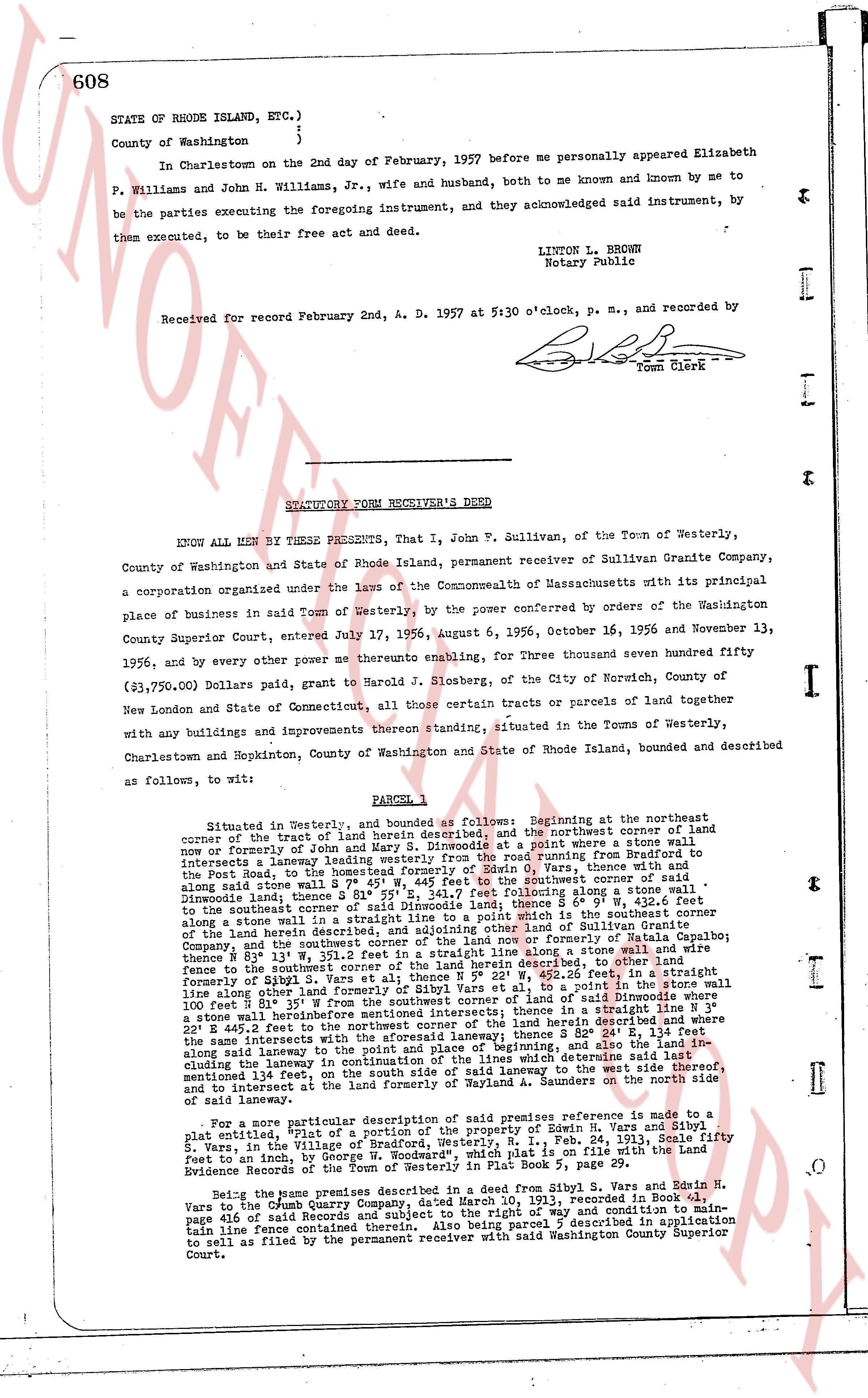
608
STATE OF RHODE ISLAND, ETC.)
)
County of Washington )
In Charlestown on the 2nd day of February, 1957 before me personally appeared Elizabeth
P. Williams and John H. Williams, Jr., wife and husband, both to me known and known by me to
be the parties executing the foregoing instrument, and they acknowledged said instrument, by
them executed, to be their free act and deed.
LINTON L. BROWN
Notary Public
Received for record February 2nd, A. D. 1957 at 5:30 o'clock, p. m., and recorded by
[Signature]
Town Clerk
----
STATUTORY FORM RECEIVER'S DEED
KNOW ALL MEN BY THESE PRESENTS, that I, John F. Sullivan, of the Town of Westerly,
County of Washington and State of Rhode Island, permanent receiver of Sullivan Granite Company,
a corporation organized under the laws of the Commonwealth of Massachusetts with its principal
place of business in said Town of Westerly, by the power conferred by orders of the Washington
County Superior Court, entered July 17, 1956, August 6, 1956, October 16, 1956 and November 13,
1956, and by every other power me heretofore enabling, for Three thousand seven hundred fifty
($3,750.00) Dollars paid, grant to Harold J. Slosberg, of the City of Norwich, County of
New London and State of Connecticut, certain tracts or parcels of land together
with any buildings and improvements thereon standing, situated in the Towns of Westerly,
Charlestown and Hopkinton, County of Washington and State of Rhode Island, bounded and described
as follows, to wit:
PARCEL 1
Situated in Westerly, and bounded as follows: Beginning at the northeast corner
of the tract of land herein described, and the northeast corner of land now
or formerly of [?] and [?] and running by a stone wall to a point borne s 14° 30' w
intersecting a boundary leading westerly from the road running from Bradford to
the Post Road, to the Homestead formerly of S. S. [?], 11.12 chains then s 14° 30' w
along said stone wall to a point borne s 14° 30' w at the southeast corner of said
Diwondee tract; thence s 11° 55' w 241.7 feet following stone wall to a point; thence S 4° 26' w 432.6
feet along the south line of the Diwondee tract; thence S 4° 26' w 111.1 feet along
a stone wall in a straight line to a point which is the southeast corner of
the south line of the Diwondee tract or land of Sullivan Granite Company,
and the southeast corner of the land now or formerly of Natalia Farnham;
thence N 81° 35' e 231.1 feet along a stone wall along a straight line from the south-
fence to the southeast corner of the land herein described, to other land formerly
of [?] and [?] thence N 81° 35' e 111.1 feet along a stone wall to a point in the stone wall
100 feet along shore line of land formerly of [?] Vars et al., to a point in the stone wall
100 feet along shore line N 81° 35' w from the southeastmost intersection; thence in a straight line N 3°
w 345.5 feet along boundary line of land of [?] which line is parallel to the stone wall
E 28° 44.5' west to the northeast corner of the subject tract, which line is parallel to the
same line mentioned with the first call of this description; thence S 82° 24' E 134.1 feet
along said laneway to the point of origin and beginning, and in the land of [?] along
the stone wall [?] and [?] along said laneway to the point of beginning, and in the land of [?] along
mentioned 134 feet, on the south side of said laneway to the west side thereof,
33 feet in diameter at the least width of said laneway, S 82° 24' E 134.1 feet along the
edge of said laneway.
For a more particular description of said premises reference is made to a
plat, [?] portion of a section of the property of Edwin H. Vars and Sibil
Vars, in the Village of Bradford, Westerly, N. H., Feb. 24, 1913, Scale fifty
feet to an Inch, by George [?]. A copy of said plat is on file with the Registry
of Evidence Records of the Town of Westerly in Plat Book 5, page 20.
Being the same premises described in a deed from Sibil Y. Vars and Edwin H.
Vars to the Dumb Quarry Company, dated March 10, 1913, recorded in Book 41,
page 618 of said Records, reserving a right of way and condition to main-
tain line fences contained therein. Also being parcel 5 described in application
to sell as filed by the permanent receiver with said Washington County Superior
Court.
page 2 · read by Gemma vision
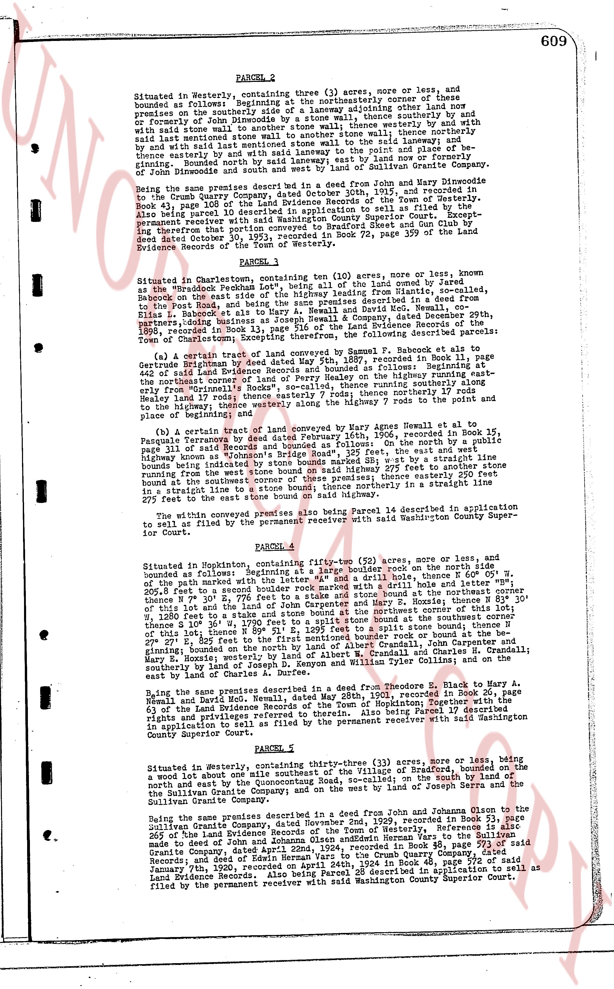
609
PAGE 2
Situated in Westerly, containing three (3) acres, more or less, and bounded as follows: Beginning at the southeasterly corner of these premises; thence southeasterly by a laneway adjoining other land now or formerly owned by Gertrude Brightman to a stone wall; thence southerly by and with said stone wall to another stone wall; thence westerly by and with said stone wall to another stone wall; thence northerly by and with said last mentioned stone wall to the said laneway; and thence northerly by and with said laneway stone wall to the point of place and beginning. Bounded north by said laneway; east by land or formerly owning John Dinwiddie and south by a stone wall and of Sullivan Granite Co.
Being the same premises described in a Deed from John and Mary Dinwiddie to the Crumb Quarry Company, dated October 30th, 1911, and recorded in Book 269, page 100 of the land evidence records of the Town of Westerly. Also being parcel 10 described in application to sell as filed by the permanent receiver with said Washington County Superior Court. Excepting however that portion conveyed to Bradford 석et and Crumb by Lin Gulf see Deed dated October 30, 1952, recorded in Book 72, page 309 of the land Evidence Records of the Town of Westerly.
PARCEL 3
Situated in Charlestown, containing ten (10) acres, more or less, known as the "Braddock Peach Orchard" Lot 102, being all of the land owned by Jared Babock on the east side of Highway 16, his Highway leading from Niantic, so called, to the Post Road, and being the same premises described in a Deed from Jared Babock, his heirs and assigns and David McC. Newell, co-partners, doing business as Joseph Newell & Company, dated December 29th, 1898, recorded in Book 186, page 108 of the Land Evidence Records of the Town of Charlestown; Excepting therefrom, the following described parcels:
(a) A certain tract of land conveyed by Samuel F. Babock et al to George Birtchum by Indenture dated November 18, 1903, recorded in Book 186 page 442 of said Land Evidence Records and bounded as follows: Beginning at the northeast corner of land of Parcel 10 on the Highway running southeast from the highway from Brightman's corner, thence running southerly 17 rods to the highway; then westerly 17 rods; thence northerly 17 rods to the point of place and beginning; and
(b) A certain tract of land conveyed by Mary Agnes Howell et al to Patience Farnham by Deed dated February 16th, 1906, recorded in Book 195, page 311 of said records and bounded as follows: on the east, the way and west boundary being a threaded stone wall running 227 feet to the street line running from the way to the southeast corner of these premises; thence easterly 200 feet in a straight line from the way to the southeast corner of these premises; thence northerly in a straight line 200 feet to the east street bound on said highway.
The within conveyed premises also being Parcel 14 described in application to sell as filed by the permanent receiver with said Washington County Superior Court.
PARCEL 4
Situated in Hopkinton, containing fifty-two (52) acres, more or less, and bounded as follows: Beginning at a stone wall with a drill hole on the north side of the way marked with an "X" and a drill hole, thence N 60° W, by the way 205.8 feet to a second border marked with a drill hole and "X" stone wall N 30° E, 770 feet to a stone wall with a drill hole at the northeast corner of this lot and the land of John Carpenter and Mary E. Hosie; thence N 83° 30' W, 120 feet to a second stone wall; thence N 15° W, 100 feet to a stone wall; thence N 120 feet to a second stone wall; thence S 19° 30' W, 170 feet to a split stone bound at the southeast corner of this lot; thence N 89° 51' E, 127 feet to a contoured border rock or bound at the SE corner 227 feet to the east street bound on a contoured border rock or bound at the SE corner, beginning on the bound north by the land of Crandall, John H. Crandall and Mary E. Hosie; westerly by the land of Albert W. Crandall and Charles H. Crandall; southerly by the land of Depon K. Zepyon and William Tyler Collins; and on the east by the land of Charles Crandall.
Being the same premises described in a Deed from Theodore E. Black to Mary A. Newell and David McC. Newell, dated May 28th, 1901, recorded in Book 20, page 63 of the Land Evidence Records of the Town of Hopkinton; Therefore including all rights and privileges referred to therein. Also being Parcel 17 described in application to sell as filed by the permanent receiver with said Washington County Superior Court.
PARCEL 5
Situated in Westerly, containing one-three (33) acres, more or less, being a wood lot above and to the southwest of the Village of Bradford, bounded on the north and east by the Quonochontaug Road, so called; on the south by the land of the Sullivan Granite Company and on the west by the land of John Sepra and the Sullivan Granite Company.
Being the same premises described in a Deed from John and Johnson Olson to the Sullivan Granite Company, dated November 2nd, 1929, recorded in Book 312, page 265 of the land evidence records of the Town of Westerly. This parcel is also made part of Deed of John Olsen and Edwin Herman Yars to the Sullivan Granite Company, dated April 1st, 1933, recorded in Book 333, page 113 said Records; and of Deed of Edwin Herman Yars to the Crumb Quarry Company, dated January 7th, 1920, recorded on April 24th, 1920. Also being Parcel 28 described in application to sell as filed by the permanent receiver with said Washington County Superior Court.
page 3 · read by Gemma vision
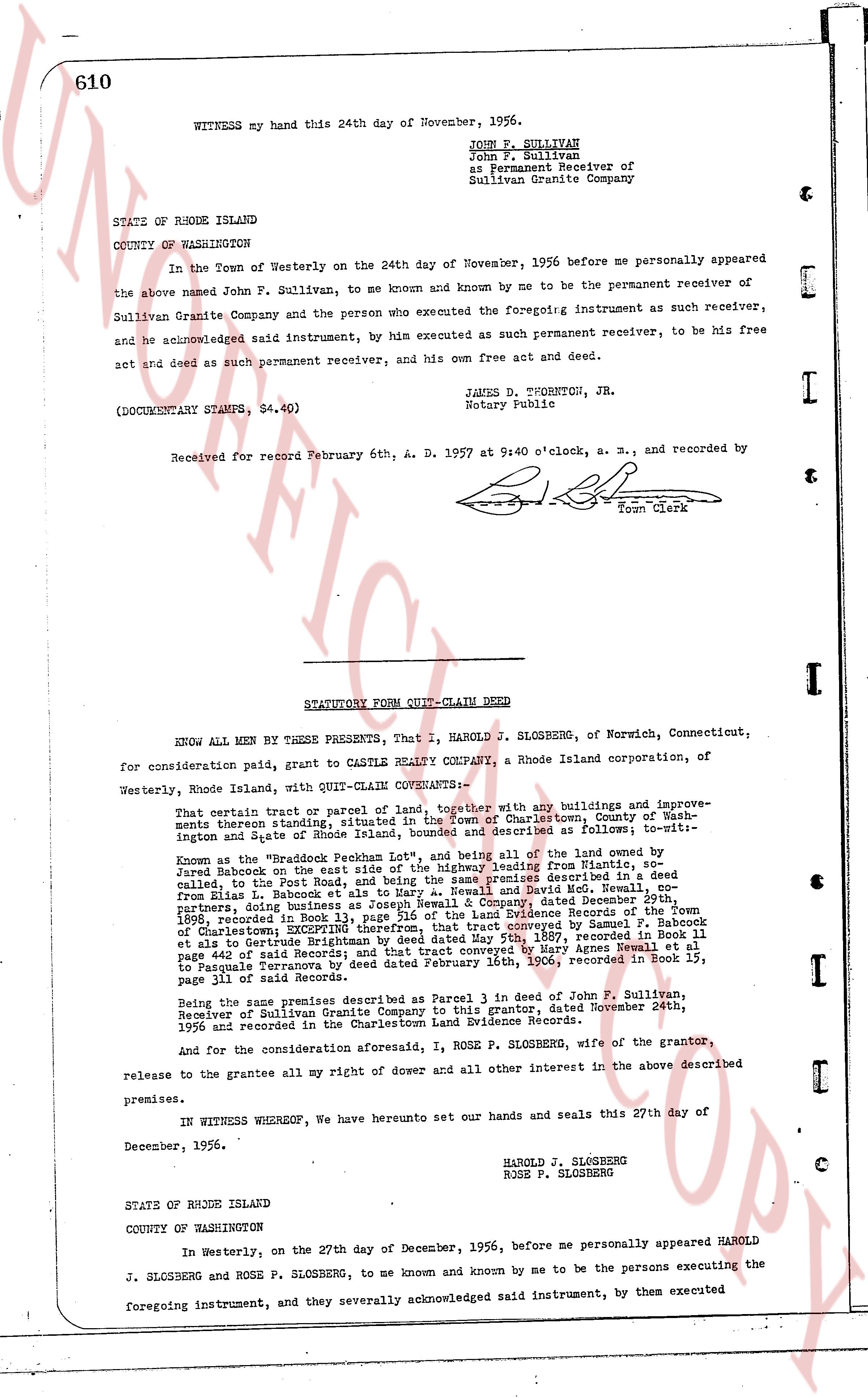
WITNESS my hand this 24th day of November, 1956.
JOHN F. SULLIVAN
John F. Sullivan
as Permanent Receiver of
Sullivan Granite Company
STATE OF RHODE ISLAND
COUNTY OF WASHINGTON
In the Town of Westerly on the 24th day of November, 1956 before me personally appeared the above named John F. Sullivan, to me known and known by me to be the permanent receiver of Sullivan Granite Company and the person who executed the foregoing instrument as such receiver, and he acknowledged said instrument, by him executed as such permanent receiver, to be his free act and deed as such permanent receiver, and his own free act and deed.
JAMES D. THORPTON, JR.
Notary Public
(DOCUMENTARY STAMPS, $4.40)
Received for record February 6th, A. D. 1957 at 9:40 o'clock, and recorded by [Signature]
Town Clerk
----
STATUTORY FORM QUIT-CLAIM DEED
KNOW ALL MEN BY THESE PRESENTS, That I, HAROLD J. SLOSBERG, of Norwich, Connecticut, for consideration paid, grant to CASTLE REALTY COMPANY, a Rhode Island corporation, of Westerly, Rhode Island, with QUIT-CLAIM COVENANTS:
That certain Part - Parcel of Land [?] together with any buildings and improvements thereon situated, situated in the Town of Charlestown, County of Washington and State of Rhode Island, bounded and described as follows; to-wit-
Known as the "Braddock Peach Lot", and being all of the land owned by Jared Babcock on the east side of the road leading from Ninigret to the Post Road, called in the Post Road and being the same premises described in a deed from Elias L. Babcocks et als to Amy A. Rawley and Ida M. Rawley dated November 24th, 1892, recording in Book 13 page 516 of the Land Evidence Records of the Town of Charlestown, 1892, incorporated into the premises conveyed by Samuel F. Babcock et als to Gurlette Brightman by deed dated May 5th, 1897, recorded in Book 11 page 401 of said Records and subsequently conveyed to Mary Agnes Thorp dated June 21 to Pasquale Terranova by deed dated February 16th, 1906, recorded in Book 15, page 311 of said Records.
Being the same premises described as Parcel 3 in deed to John F. Sullivan, Receiver of Sullivan Granite Company to this grantor, dated November 24th, 1956 and recorded in the Charlestown Land Evidence Records.
And for the consideration aforesaid, I, ROSE P. SLOSBERG, wife of the grantor, release to the grantee all my right of dower and all other interest in the above described premises.
IN WITNESS WHEREOF, We have hereunto set our hands and seals this 27th day of December, 1956.
HAROLD J. SLOSBERG
ROSE P. SLOSBERG
STATE OF RHODE ISLAND
COUNTY OF WASHINGTON
In Westerly, on the 27th day of December, 1956, before me personally appeared HAROLD J. SLOSBERG and ROSE P. SLOSBERG, to me known and known by me to be the persons executing the foregoing instrument, and they severally acknowledged said instrument, by them executed
The page as recorded