The instrument's own words
page 1 · read by Gemma vision
607
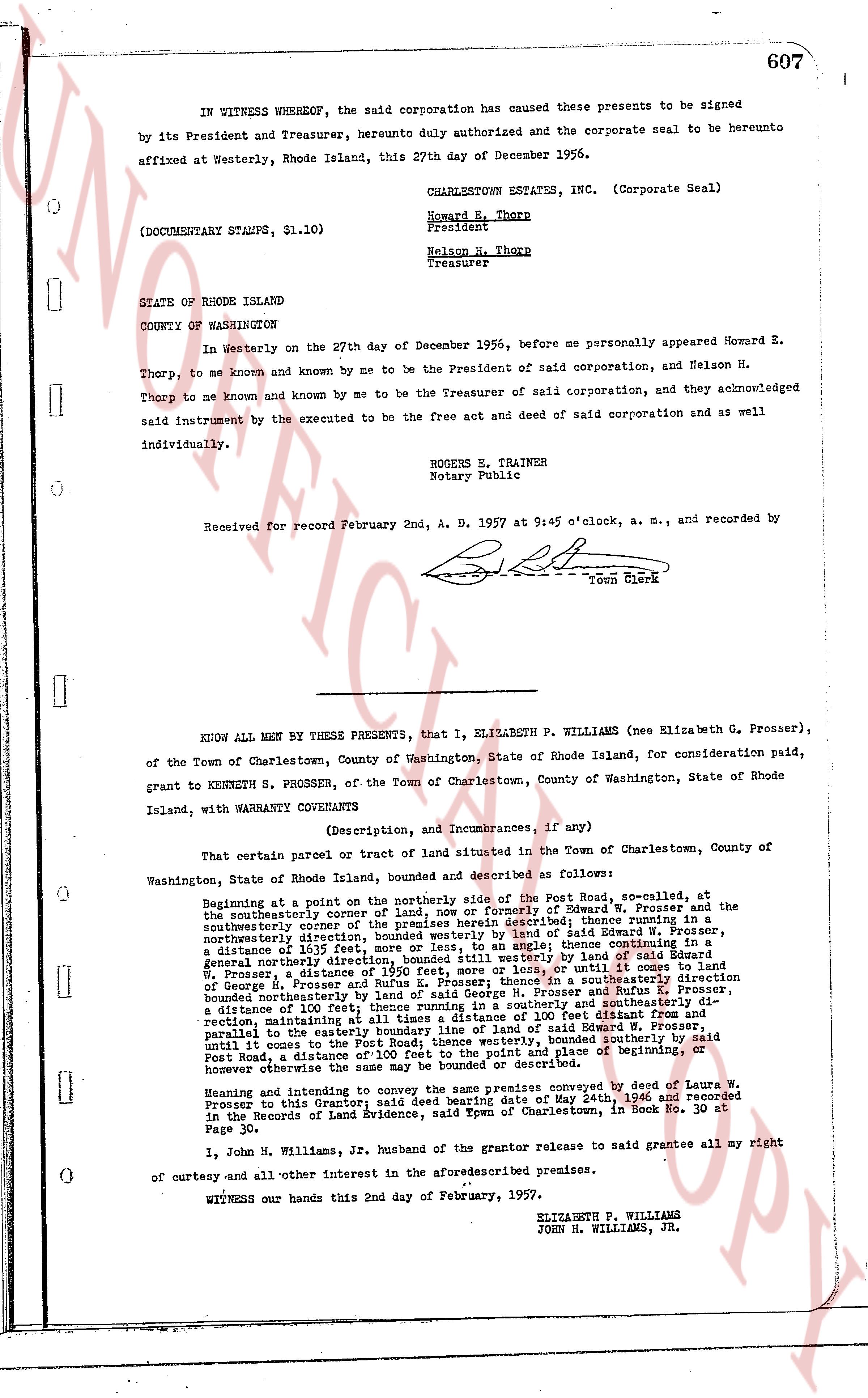
IN WITNESS WHEREOF, the said corporation has caused these presents to be signed by its President and Treasurer, hereunto duly authorized and the corporate seal to be hereunto affixed at Westerly, Rhode Island, this 27th day of December 1956.
CHARLESTOWN ESTATES, INC. (Corporate Seal)
Howard E. Thorp
President
Nelson H. Thorp
Treasurer
(DOCUMENTARY STAMPS, $1.10)
STATE OF RHODE ISLAND
COUNTY OF WASHINGTON
In Westerly on the 27th day of December 1956, before me personally appeared Howard E. Thorp, to me known and known by me to be the President of said corporation, and Nelson H. Thorp to me known and known by me to be the Treasurer of said corporation, and they acknowledged said instrument by the executed to be the free act and deed of said corporation and as well individually.
ROGERS E. THAINE
Notary Public
Received for record February 2nd, A. D. 1957 at 9:45 o'clock, a. m., and recorded by
[Signature]
Town Clerk
----
KNOW ALL MEN by THESE PRESENTS, that I, ELIZABETH P. WILLIAMS (nee Elizabeth O. Prosser), of the Town of Charlestown, County of Washington, State of Rhode Island, for consideration paid, grant to KENNETH S. PROSSER, of the Town of Charlestown, County of Washington, State of Rhode Island, with WARRANTY CONVEYANCE
(Description, and Incumbrances, if any)
That certain parcel or tract of land situated in the Town of Charlestown, County of Washington, State of Rhode Island, bounded and described as follows:
Beginning at a point on the northerly side of the Post Road, so-called, at the southeasterly corner of a certain piece of land of Edward W. Prosser and in the southeasterly corner of the premises herein described; thence running in a southeasterly direction, bounded westerly by a piece of said Edward W. Prosser, in a distance of 105 feet to an angle; thence continuing in a southeasterly, general northerly direction, bounded still westerly by land of Edward W. Prosser, a distance of 125 feet to an angle, or until it comes to land of Howard H. Prosser, a distance of 125 feet to an angle, or until it comes to land of George H. Prosser and Ruth E. Prosser; thence in a southeasterly direction bounded westerly by land of George H. Prosser and Ruth E. Prosser, a distance of 100 feet; thence running in a southerly and southeasterly direction, bounded westerly by land of Howard H. Prosser, a distance of 100 feet distant, parallel to the easterly boundary line of land of said Edward W. Prosser, until it comes to the northerly side of the Post Road, bounded southerly by said Post Road, and a distance of 100 feet to the point and place of beginning, or however otherwise the same may be bounded or described.
Meaning and intending to convey all the right title and interest now conveyed by deed of Laura W. Prosser to this Grantor; and deed bearing date of May 24th, 1946 and recorded in the Records of Land Evidence, said Town of Charlestown, in Book No. 30 at Page 30.
I, John H. Williams, Jr. husband of the grantor release to said grantee all my right of courtesy and all other interest in the aforesaid described premises.
WITNESS our hands this 2nd day of February, 1957.
ELIZABETH P. WILLIAMS
JOHN H. WILLIAMS, JR.
page 2 · read by Gemma vision
608
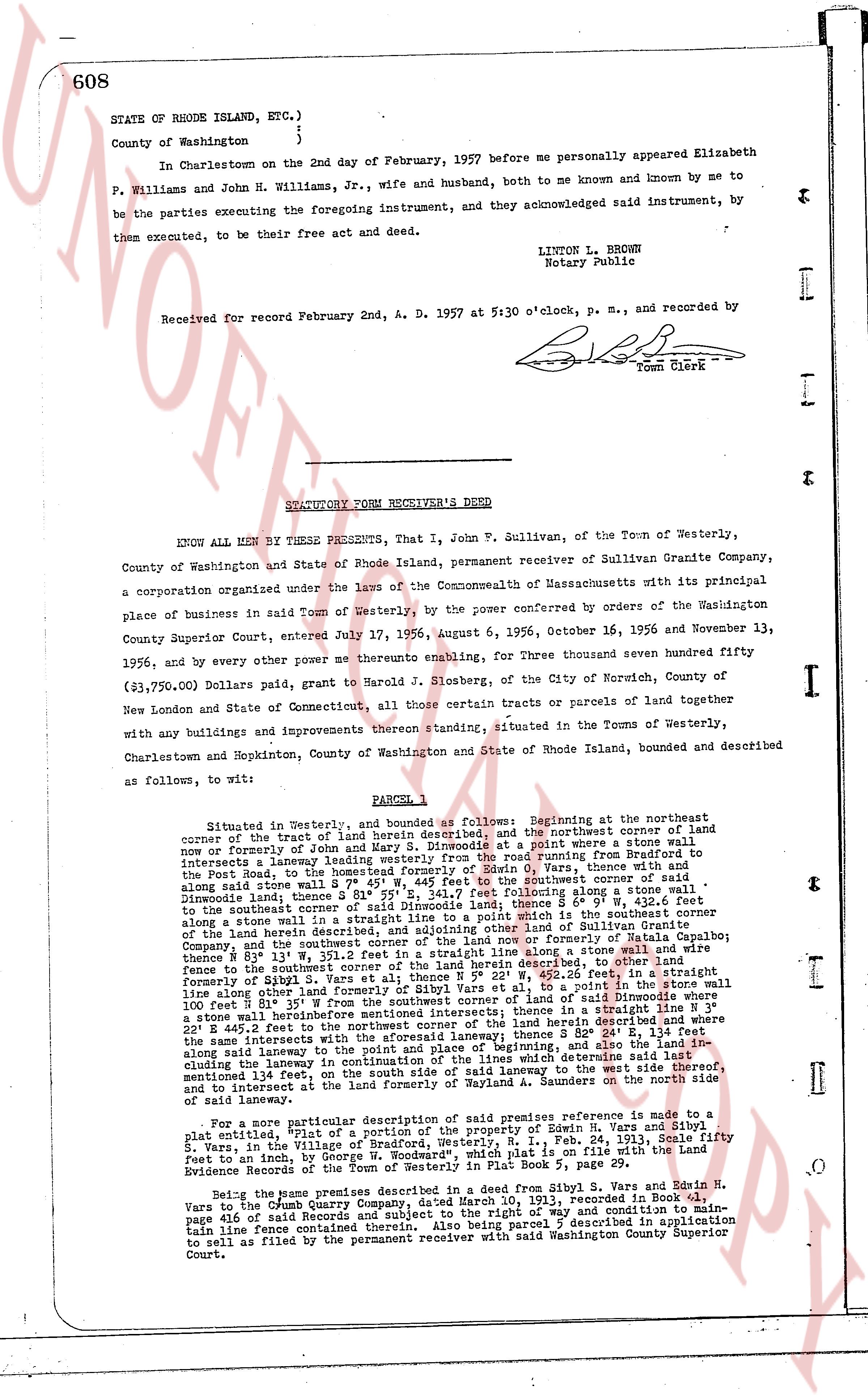
STATE OF RHODE ISLAND, ETC.)
)
County of Washington )
In Charlestown on the 2nd day of February, 1957 before me personally appeared Elizabeth Prosser, Elizabeth P. Williams, and John H. Williams, Jr., wife and husband, both to me known and known by me to be the parties executing the foregoing instrument, and they acknowledged said instrument, by them executed, to be their free act and deed.
LINTON L. BROWN
Notary Public
Received for record February 2nd, A. D. 1957 at 5:30 o'clock, p. m., and recorded by
[Signature]
Town Clerk
----
STATUTORY FORM RECEIVER'S DEED
KNOW ALL MEN BY THESE PRESENTS, that I, John F. Sullivan, of the Town of Westerly, County of Washington and State of Rhode Island, permanent receiver of Sullivan Granite Company, a corporation organized under the laws of the Commonwealth of Massachusetts with its principal place of business in said Town of Westerly, by the power conferred by orders of the Washington County Superior Court, entered July 17, 1956, August 6, 1956, October 16, 1956 and November 13, 1956, and by every other power me heretofore enabling, for Three thousand seven hundred fifty ($3,750.00) Dollars paid, grant to Harold J. Siosberg, of the City of Norwich, County of New London and State of Connecticut, certain tracts or parcels of land together with any buildings and improvements thereon standing, situated in the Towns of Westerly, Charlestown and Hopkinton, County of Washington and State of Rhode Island, bounded and described as follows, to wit:
PARCEL 1
Situated in Westerly, and bounded as follows: Beginning at the northeast corner of the tract of land herein described, and the northeast corner of land now or formerly of [?] and [?], a stone wall, at a point borne s 14 1/2 deg E 115 feet from the Post Road, to the Homestead formerly of S. S. [?], thence south 14 1/2 deg E 115 feet along said stone wall to a stone wall, thence south 82 deg W 351.4 feet to the southwest corner of said diwonde wall; thence S 14 1/2 deg W 295.1 feet, S 34 1/2 deg E 400.3 feet, S 14 1/2 deg E 432.6 feet along the south line of land of Sullivan Granite Company, thence S 82 deg W 351.4 feet in a straight line to a point which is the southwest corner of the south line of land of Sullivan Granite Company, thence S 14 1/2 deg W 295.1 feet, thence W 31 deg S 110 feet along a stone wall now or formerly of Natalia Fabiano, Company, and the southwest corner of the land herein now or formerly of Natalia Fabiano, Company; thence W 31 deg S 110 feet along a stone wall, thence S 14 1/2 deg E 432.6 feet, thence S 82 deg W 351.4 feet along a stone wall to a point which is the southeast corner of the land herein now or formerly of Natalia Fabiano, to other land formerly of S. S. [?], thence S 14 1/2 deg E 115 feet along there land formerly of Sibils Vars et al., to a point in the stone wall 100 feet along shore S 18 deg W 35 feet from the southwestmost intersection; thence in a straight line N 31 deg W 110 feet along shore with boundary of land of Sibils Vars et al., thence S 14 1/2 deg W 225 feet, E 245.5 feet to the northeast corner of the land which is a point which is the same distance and direction from the northeast corner of the land herein described, thence S 82 deg E 284 feet, 134 feet along said laneway to the point of origin and beginning, and in a straight line N 14 1/2 deg E 115 feet along said laneway to the point of beginning, and in a straight line N 14 1/2 deg E 115 feet along said laneway to the point of beginning, and in a straight line N 14 1/2 deg E 115 feet along said laneway to the point of beginning, and in a straight line N 14 1/2 deg E 115 feet along said laneway to the point of beginning, and in a straight line N 14 1/2 deg E 115 feet along said laneway to the point of beginning, and in a straight line N 14 1/2 deg E 115 feet along said laneway to the point of beginning, and in a straight line N 14 1/2 deg E 115 feet along said laneway to the point of beginning, and in a straight line N 14 1/2 deg E 115 feet along said laneway to the point of beginning, and in a straight line N 14 1/2 deg E 115 feet along said laneway to the point of beginning, and in a straight line N 14 1/2 deg E 115 feet along said laneway to the point of beginning, and in a straight line N 14 1/2 deg E 115 feet along said laneway to the point of beginning, and in a straight line N 14 1/2 deg E 115 feet along said laneway to the point of beginning, and in a straight line N 14 1/2 deg E 115 feet along said laneway to the point of beginning, and in a straight line N 14 1/2 deg E 115 feet along said laneway to the point of beginning, and in a straight line N 14 1/2 deg E 115 feet along said laneway to the point of beginning, and in a straight line N 14 1/2 deg E 115 feet along said laneway to the point of beginning, and in a straight line N 14 1/2 deg E 115 feet along said laneway to the point of beginning, and in a straight line N 14 1/2 deg E 115 feet along said laneway to the point of beginning, and in a straight line N 14 1/2 deg E 115 feet along said laneway to the point of beginning, and in a straight line N 14 1/2 deg E 115 feet along said laneway to the point of beginning, and in a straight line N 14 1/2 deg E 115 feet along said laneway to the point of beginning, and in a straight line N 14 1/2 deg E 115 feet along said laneway to the point of beginning, and in a straight line N 14 1/2 deg E 115 feet along said laneway to the point of beginning, and in a straight line N 14 1/2 deg E 115 feet along said laneway to the point of beginning, and in a straight line N 14 1/2 deg E 115 feet along said laneway to the point of beginning, and in a straight line N 14 1/2 deg E 115 feet along said laneway to the point of beginning, and in a straight line N 14 1/2 deg E 115 feet along said laneway to the point of beginning, and in a straight line N 14 1/2 deg E 115 feet along said laneway to the point of beginning, and in a straight line N 14 1/2 deg E 115 feet along said laneway to the point of beginning, and in a straight line N 14 1/2 deg E 115 feet along said laneway to the point of beginning, and in a straight line N 14 1/2 deg E 115 feet along said laneway to the point of beginning, and in a straight line N 14 1/2 deg E 115 feet along said laneway to the point of beginning, and in a straight line N 14 1/2 deg E 115 feet along said laneway to the point of beginning, and in a straight line N 14 1/2 deg E 115 feet along said laneway to the point of beginning, and in a straight line N 14 1/2 deg E 115 feet along said laneway to the point of beginning, and in a straight line N 14 1/2 deg E 115 feet along said laneway to the point of beginning, and in a straight line N 14 1/2 deg E 115 feet along said laneway to the point of beginning, and in a straight line N 14 1/2 deg E 115 feet along said laneway to the point of beginning, and in a straight line N 14 1/2 deg E 115 feet along said laneway to the point of beginning, and in a straight line N 14 1/2 deg E 115 feet along said laneway to the point of beginning, and in a straight line N 14 1/2 deg E 115 feet along said laneway to the point of beginning, and in a straight line N 14 1/2 deg E 115 feet along said laneway to the point of beginning, and in a straight line N 14 1/2 deg E 115 feet along said laneway to the point of beginning, and in a straight line N 14 1/2 deg E 115 feet along said laneway to the point of beginning, and in a straight line N 14 1/2 deg E 115 feet along said laneway to the point of beginning, and in a straight line N 14 1/2 deg E 115 feet along said laneway to the point of beginning, and in a straight line N 14 1/2 deg E 115 feet along said laneway to the point of beginning, and in a straight line N 14 1/2 deg E 115 feet along said laneway to the point of beginning, and in a straight line N 14 1/2 deg E 115 feet along said laneway to the point of beginning, and in a straight line N 14 1/2 deg E 115 feet along said laneway to the point of beginning, and in a straight line N 14 1/2 deg E 115 feet along said laneway to the point of beginning, and in a straight line N 14 1/2 deg E 115 feet along said laneway to the point of beginning, and in a straight line N 14 1/2 deg E 115 feet along said laneway to the point of beginning, and in a straight line N 14 1/2 deg E 115 feet along said laneway to the point of beginning, and in a straight line N 14 1/2 deg E 115 feet along said laneway to the point of beginning, and in a straight line N 14 1/2 deg E 115 feet along said laneway to the point of beginning, and in a straight line N 14 1/2 deg E 115 feet along said laneway to the point of beginning, and in a straight line N 14 1/2 deg E 115 feet along said laneway to the point of beginning, and in a straight line N 14 1/2 deg E 115 feet along said laneway to the point of beginning, and in a straight line N 14 1/2 deg E 115 feet along said laneway to the point of beginning, and in a straight line N 14 1/2 deg E 115 feet along said laneway to the point of beginning, and in a straight line N 14 1/2 deg E 115 feet along said laneway to the point of beginning, and in a straight line N 14 1/2 deg E 115 feet along said laneway to the point of beginning, and in a straight line N 14 1/2 deg E 115 feet along said laneway to the point of beginning, and in a straight line N 14 1/2 deg E 115 feet along said laneway to the point of beginning, and in a straight line N 14 1/2 deg E 115 feet along said laneway to the point of beginning, and in a straight line N 14 1/2 deg E 115 feet along said laneway to the point of beginning, and in a straight line N 14 1/2 deg E 115 feet along said laneway to the point of beginning, and in a straight line N 14 1/2 deg E
The page as recorded