The instrument's own words
page 1 · read by Gemma vision
593
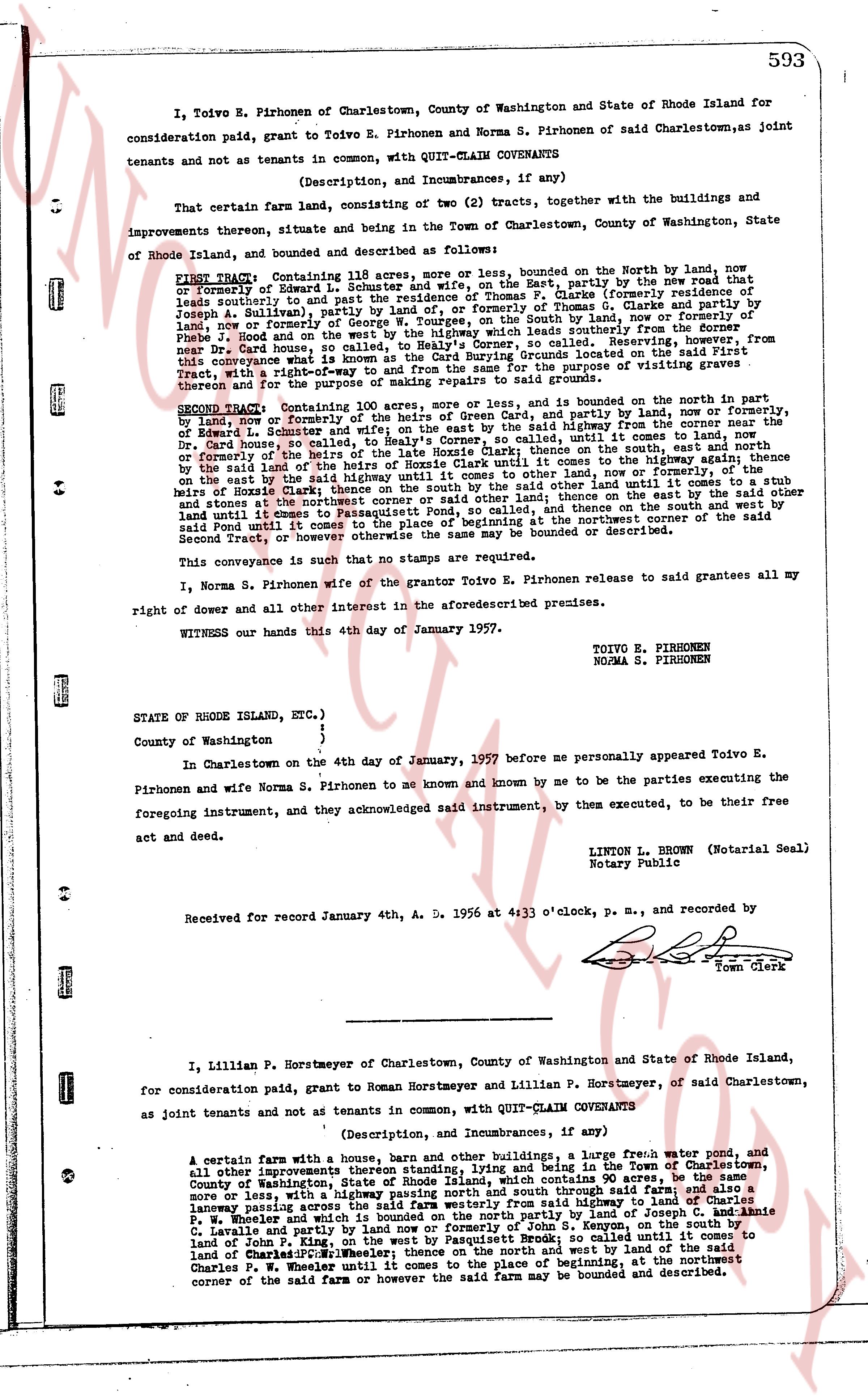
I, Toivo E. Pirhonen of Charlestown, County of Washington and State of Rhode Island for
consideration paid, grant to Toivo E. Pirhonen and Norma S. Pirhonen of said Charlestown, as joint
tenants and not as tenants in common, with QUIT-CLAIM COVENANTS
(Description, and Incumbrances, if any)
That certain farm land, consisting of two (2) tracts, together with the buildings and with the
improvements thereon, situate and being in the Town of Charlestown, County of Washington, State
of Rhode Island, and bounded and described as follows:
FIRST Tract: Containing 118 acres, more or less, bounded on the North by land, now
or formerly of Edward E. Moore and heirs, on the East, by partly by the new road that
leads southerly to and partly by the residence of Thomas S. Clarke, and partly by land of
Joseph A. Allison, and partly by the residence of Thomas S. Clarke and partly by land of
land, now or formerly of George W. Tourges, on the South by land, now or formerly of
phrase J. Hood and on the West, by a road leading southerly from the [?] road from
New York State, Charlestown, sc, called to Nelly's Corner, saving, reserving, from however, from
this conveyance what is known as the "Cut Corner", consisting of 2 acres located on the southeast
thereof and for the purpose of making repairs to said ground.
SECOND Tract: Containing 100 acres, more or less, and bounded on the north in part
by land, now or formerly of Th. S. Clarke and heirs, and partly by land, now or formerly,
of Edward L. Schuster and wife; and on the east by the said highway; thence to the south,
by the Dr. Gurl farm, south easterly along the said highway until it comes to land, now
or formerly of the heirs of the late Hosie Clarke; thence to the south, east north by the
said highway, thence to the south, east north by the said highway, thence to the high way, thence
on the east by the said highway until it comes to land, now or formerly, of
stoney and heirs of Hosie Clarke; thence to the south, east north until it comes to a stub
and stone at the northwest corner or said other land; thence on the east by the said other
land until it comes to Passaconawut Road; thence to the north, east north by the said
Passaconawut Road until it comes to place of beginning at the northeast corner of the said
Second Tract, or however otherwise the same may be bounded or described.
This conveyance is such that no stamps are required.
I, Norma S. Pirhonen wife of the grantor Toivo E. Pirhonen release to said grantees all my
right of dower and all other interest in the aforesaid described premises.
WITNESS our hands this 4th day of January 1957.
TOIVO E. PIRHONEN
NORMA S. PIRHONEN
STATE of RHODE ISLAND, ETC. }
}
County of Washington }
In Charlestown on the 4th day of January, 1957 before me personally appeared Toivo E.
Pirhonen and wife Norma S. Pirhonen as known and known by me to be the parties executing the
foregoing instrument, and they acknowledged said instrument, by them executed, to be their
free
act and deed.
LINTON L. BROWN (Notarial Seal)
Notary Public
Received for record January 4th, A. D. 1956 at 4:33 o'clock, p. m., and recorded by
Town Clerk
----
I, Lillian P. Horstmeyer of Charlestown, County of Washington and State of Rhode Island,
for consideration paid, grant to Roman Horstmeyer and Lillian P. Horstmeyer, of said Charlestown,
as joint tenants and not as tenants in common, with QUIT-CLAIM COVENANTS
(Description, and Incumbrances, if any)
A certain farm with a house, barn and other buildings, a large fresh water pond, and
all other improvements thereon standing, lying and being in the Town of Charlestown,
County of Washington, State of Rhode Island, bounded on the North by 90 acres more
or less, with a highway running north and south through said farm; and also a
laneway passing across the said farm westerly from said highway to land of Joseph C. and Annie
L. Weaver and wife and partly by land now or formerly of John S. Kenyon, on the south by the
land of John S. Kenyon and partly by a road called the sawmill road leading to the
land of Charles P. Wheeler; thence on the north and west by land of the said
Charles P. Wheeler until it comes to the place of beginning at the northeast
corner of the said farm or however the said farm may be bounded and described.
page 2 · read by Gemma vision
594
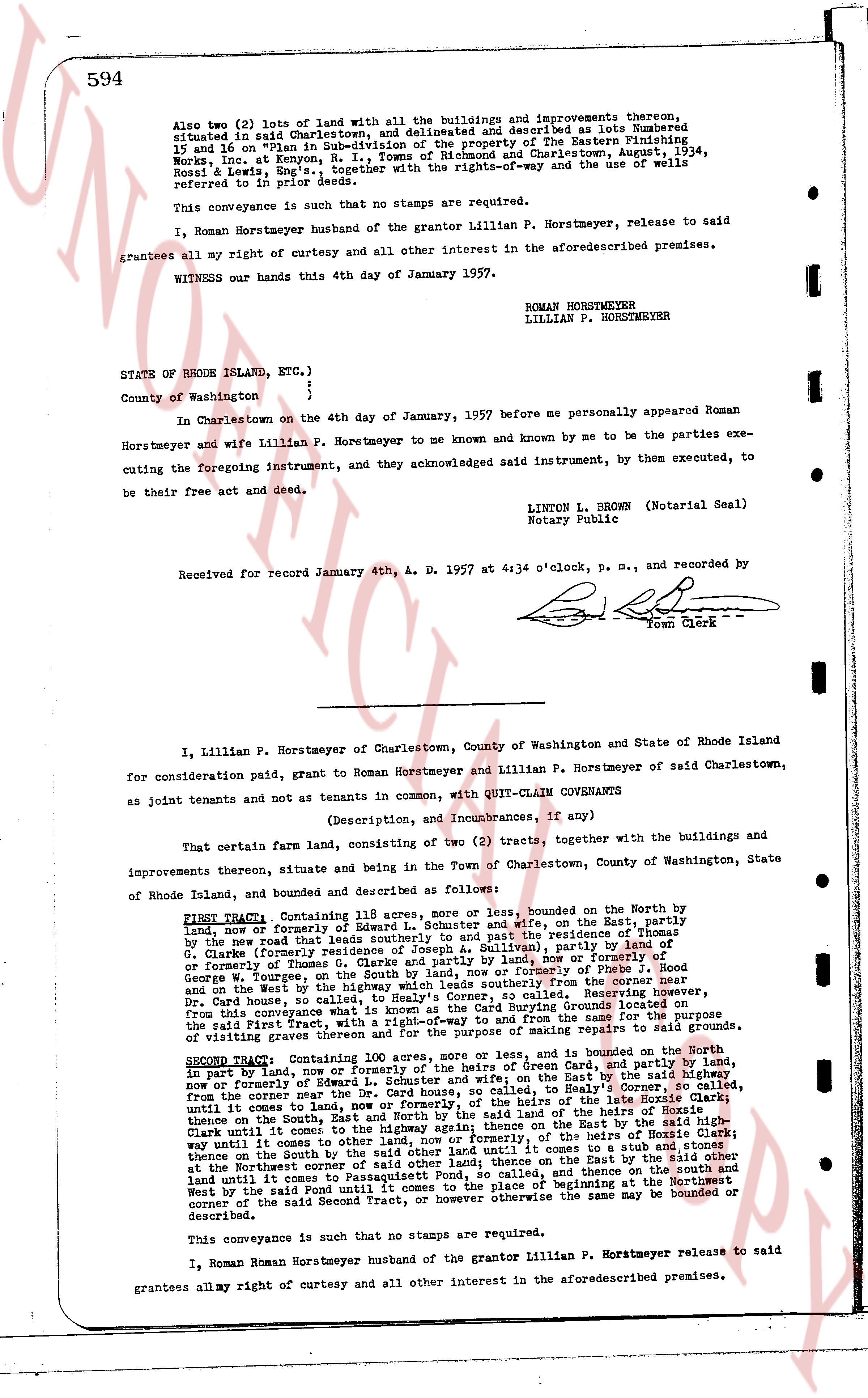
Also two (2) lots of land with all the buildings and improvements thereon, situated in said Charlestown, and delineated and described as lots Numbered 15 and 16 on "Plan in Sub-division of the property of the Eastern Publishing Works, Inc. at Kenyon, R. I., Towns of Richmond and Charlestown August 1934, Ross & Lewis, Eng's", together with the rights-of-way and the use of wells referred to in prior deeds.
This conveyance is such that no stamps are required.
I, Roman Horstmeyer husband of the grantor Lillian P. Horstmeyer, release to said grantees all my right of curtesy and all other interest in the aforementioned premises.
WITNESS our hands this 4th day of January 1957.
ROMAN HORSTMEYER
LILLIAN P. HORSTMEYER
STATE OF RHODE ISLAND, ETC.)
)
County of Washington )
In Charlestown on the 4th day of January, 1957 before me personally appeared Roman Horstmeyer and wife Lillian P. Horstmeyer to me known and known by me to be the parties executing the foregoing instrument, and acknowledged said instrument, by them executed, to be their free act and deed.
LINTON L. BROWN (Notarial Seal)
Notary Public
Received for record January 4th, A. D. 1957 at 4:34 o'clock, p. m., and recorded by
[Signature]
Town Clerk
----
I, Lillian P. Horstmeyer of Charlestown, County of Washington and State of Rhode Island for consideration paid, grant to Roman Horstmeyer and Lillian P. Horstmeyer of said Charlestown, as joint tenants and not as tenants in common, with QUIT-CLAIM COVENANTS
(Description, and Incumbrances, if any)
That certain farm land, consisting of two (2) tracts, together with the buildings and improvements thereon, situate and being in the Town of Charlestown, County of Washington, State of Rhode Island, land and bounded and described as follows:
FIRST TRACT: Containing 121 acres, more or less, bounded on the North by the land, now or formerly of Edward L. Schuster and wife, on the East, partly by the new road that leads southerly to and past the entrance of the entrance of G. Clarke formerly of this town, and partly by the [?] driveway, partly by land of G. Clarke formerly of this town, and partly by the road, now or formerly of Thomas G. Clarke partly and land now or formerly of S. Wood & George W. Burgess, on the North, partly by the road, now or formerly of the heirs of H. Wood and on the West by the highway which leads southerly from the corner near the Dr. Card house, to the corner of the land of G. Colley, beginning at the corner near the Dr. Card house, and running thence southerly along said highway to the corner of the land of the said First Tract, and running thence southerly along the said highway to the corner of the said First Tract, and running thence southerly along the said highway to the corner of the said First Tract, and running thence southerly along the said highway to the corner of the said First Tract, and running thence southerly along the said highway to the corner of the said First Tract, and running thence southerly along the said highway to the corner of the said First Tract, and running thence southerly along the said highway to the corner of the said First Tract, and running thence southerly along the said highway to the corner of the said First Tract, and running thence southerly along the said highway to the corner of the said First Tract, and running thence southerly along the said highway to the corner of the said First Tract, and running thence southerly along the said highway to the corner of the said First Tract, and running thence southerly along the said highway to the corner of the said First Tract, and running thence southerly along the said highway to the corner of the said First Tract, and running thence southerly along the said highway to the corner of the said First Tract, and running thence southerly along the said highway to the corner of the said First Tract, and running thence southerly along the said highway to the corner of the said First Tract, and running thence southerly along the said highway to the corner of the said First Tract, and running thence southerly along the said highway to the corner of the said First Tract, and running thence southerly along the said highway to the corner of the said First Tract, and running thence southerly along the said highway to the corner of the said First Tract, and running thence southerly along the said highway to the corner of the said First Tract, and running thence southerly along the said highway to the corner of the said First Tract, and running thence southerly along the said highway to the corner of the said First Tract, and running thence southerly along the said highway to the corner of the said First Tract, and running thence southerly along the said highway to the corner of the said First Tract, and running thence southerly along the said highway to the corner of the said First Tract, and running thence southerly along the said highway to the corner of the said First Tract, and running thence southerly along the said highway to the corner of the said First Tract, and running thence southerly along the said highway to the corner of the said First Tract, and running thence southerly along the said highway to the corner of the said First Tract, and running thence southerly along the said highway to the corner of the said First Tract, and running thence southerly along the said highway to the corner of the said First Tract, and running thence southerly along the said highway to the corner of the said First Tract, and running thence southerly along the said highway to the corner of the said First Tract, and running thence southerly along the said highway to the corner of the said First Tract, and running thence southerly along the said highway to the corner of the said First Tract, and running thence southerly along the said highway to the corner of the said First Tract, and running thence southerly along the said highway to the corner of the said First Tract, and running thence southerly along the said highway to the corner of the said First Tract, and running thence southerly along the said highway to the corner of the said First Tract, and running thence southerly along the said highway to the corner of the said First Tract, and running thence southerly along the said highway to the corner of the said First Tract, and running thence southerly along the said highway to the corner of the said First Tract, and running thence southerly along the said highway to the corner of the said First Tract, and running thence southerly along the said highway to the corner of the said First Tract, and running thence southerly along the said highway to the corner of the said First Tract, and running thence southerly along the said highway to the corner of the said First Tract, and running thence southerly along the said highway to the corner of the said First Tract, and running thence southerly along the said highway to the corner of the said First Tract, and running thence southerly along the said highway to the corner of the said First Tract, and running thence southerly along the said highway to the corner of the said First Tract, and running thence southerly along the said highway to the corner of the said First Tract, and running thence southerly along the said highway to the corner of the said First Tract, and running thence southerly along the said highway to the corner of the said First Tract, and running thence southerly along the said highway to the corner of the said First Tract, and running thence southerly along the said highway to the corner of the said First Tract, and running thence southerly along the said highway to the corner of the said First Tract, and running thence southerly along the said highway to the corner of the said First Tract, and running thence southerly along the said highway to the corner of the said First Tract, and running thence southerly along the said highway to the corner of the said First Tract, and running thence southerly along the said highway to the corner of the said First Tract, and running thence southerly along the said highway to the corner of the said First Tract, and running thence southerly along the said highway to the corner of the said First Tract, and running thence southerly along the said highway to the corner of the said First Tract, and running thence southerly along the said highway to the corner of the said First Tract, and running thence southerly along the said highway to the corner of the said First Tract, and running thence southerly along the said highway to the corner of the said First Tract, and running thence southerly along the said highway to the corner of the said First Tract, and running thence southerly along the said highway to the corner of the said First Tract, and running thence southerly along the said highway to the corner of the said First Tract, and running thence southerly along the said highway to the corner of the said First Tract, and running thence southerly along the said highway to the corner of the said First Tract, and running thence southerly along the said highway to the corner of the said First Tract, and running thence southerly along the said highway to the corner of the said First Tract, and running thence southerly along the said highway to the corner of the said First Tract, and running thence southerly along the said highway to the corner of the said First Tract, and running thence southerly along the said highway to the corner of the said First Tract, and running thence southerly along the said highway to the corner of the said First Tract, and running thence southerly along the said highway to the corner of the said First Tract, and running thence southerly along the said highway to the corner of the said First Tract, and running thence southerly along the said highway to the corner of the said First Tract, and running thence southerly along the said highway to the corner of the said First Tract, and running thence southerly along the said highway to the corner of the said First Tract, and running thence southerly along the said highway to the corner of the said First Tract, and running thence southerly along the said highway to the corner of the said First Tract, and running thence southerly along the said highway to the corner of the said First Tract, and running thence southerly along the said highway to the corner of the said First Tract, and running thence southerly along the said highway to the corner of the said First Tract, and running thence southerly along the said highway to the corner of the said First Tract, and running thence southerly along the said highway to the corner of the said First Tract, and running thence southerly along the said highway to the corner of the said First Tract, and running thence southerly along the said highway to the corner of the said First Tract, and running thence southerly along the said highway to the corner of the said First Tract, and running thence southerly along the said highway to the corner of the said First Tract, and running thence southerly along the said highway to the corner of the said First Tract, and running thence southerly along the said highway to the corner of the said First Tract, and running thence southerly along the said highway to the corner of the said First Tract, and running thence southerly along the said highway to the corner of the said First Tract, and running thence southerly along the said highway to the corner of the said First Tract, and running thence southerly along the said highway to the corner of the said First Tract, and running thence southerly along the said highway to the corner of the said First Tract, and running thence southerly along the said highway to the corner of the said First Tract, and running thence southerly along the said highway to the corner of the said First Tract, and running thence southerly along the said highway to the corner of the said First Tract, and running thence southerly along the said highway to the corner of the said First Tract, and running thence southerly along the said highway to the corner of the said First Tract, and running thence southerly along the said highway to the corner of the said First Tract, and running thence southerly along the said highway to the corner of the said First Tract, and running thence southerly along the said highway to the corner of the said First Tract, and running thence southerly along the said highway to the corner of the said First Tract, and running thence southerly along the said highway to the corner of the said First Tract, and running thence southerly along the said highway to the corner of the said First Tract, and running thence southerly along the said highway to the corner of the said First Tract, and running thence southerly along the said highway to the corner of the said First Tract, and running thence southerly along the said highway to the corner of the said First Tract, and running thence southerly along the said highway to the corner of the said First Tract, and running thence southerly along the said highway to the corner of the said First Tract, and running thence southerly along the said highway to the corner of the said First Tract, and running thence southerly along the said highway to the corner of the said First Tract, and running thence southerly along the said highway to the corner of the said First Tract, and running thence southerly along the said highway to the corner of the said First Tract, and running thence southerly along the said highway to the corner of the said First Tract, and running thence southerly along the said highway to the corner of the said First Tract, and running thence southerly along the said highway to the corner of the said First Tract, and running thence southerly along the said highway to the corner of the said First Tract, and running thence southerly along the said highway to the corner of the said First Tract, and running thence southerly along the said highway to the corner of the said First Tract, and running thence southerly along the said highway to the corner of the said First Tract, and running thence southerly along the said highway to the corner of the said First Tract, and running thence southerly along the said highway to the corner of the said First Tract, and running thence southerly along the said highway to the corner of the said First Tract, and running thence southerly along the said highway to the
The page as recorded