The instrument's own words
page 1 · read by Gemma vision
569
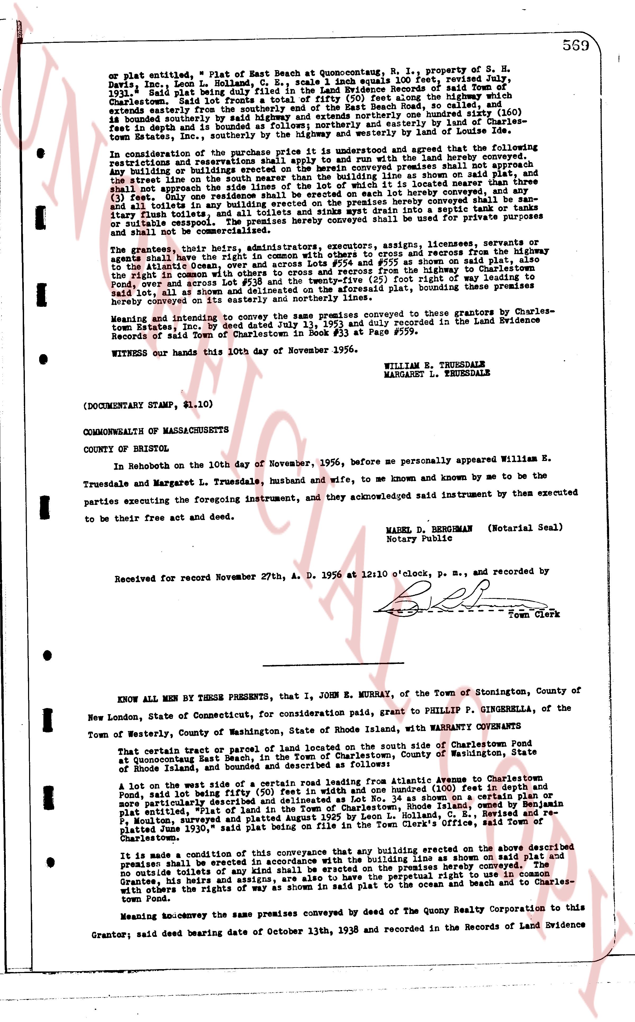
on plat entitled, " Plat of East Beach at Quonsetpoint, R. I., property of S. H.
Davis, Inc." Leon L. Holland, C. E., scale 1 inch equals 100 feet, revised July,
1931. said Plat being duly filed in the Land Evidence Books of said Town of
Charlestown. Said lot fronts easterly on the highway 135 feet along the highway, which
extends southerly from the easterly extremity of the East Beach Road, so called, and is
bounded southerly by said highway and extends southerly one hundred (100) feet in
depth and is bounded southerly by the highway and easterly by land of Charles-
town Estates, Inc., southerly by the highway and westerly by land of Lot number (160).
In consideration of the purchase price the is understood and agreed that the following
restrictions run with the land and shall be binding on the land hereby conveyed:
any building or buildings erected on the herein conveyed premises shall not appertain
the street line as defined in the plat and shall be set back 25 feet from the plat, and shall
not approach the side lines of the lot with the intent of it located no nearer than three
(3) feet. Any and all toilets and any building erected on the premises hereby conveyed shall be san-
itary flush toilets, and all toilets and septic tanks installed in lots a septic system shall be
or stable coated, and the premises hereby conveyed shall be used for private purposes
only and shall not be commercialized.
The grantors, their heirs, administrators, executors, assigns, licensees, servants or
agents shall have the right of way in common with others to and from recesses from the highway
to the Atlantic Ocean, over and across the way as shown in said plat as an alley 25 feet wide on the
plat, in common with others, across the highway and recess from the highway to Charlestown
Pond, over and across Lot #38 and the twenty-five (25) feet of right of way leading to
said lot, all such rights of way being as shown in said plat, bounding these premises
hereby conveyed on its easterly and northerly lines.
Meaning and intending to convey the same premises conveyed to grantors by Charles-
town Estates, Inc. by deed dated July 1, 1951 and recorded in the Land Evidence
Records of said Town of Charlestown in Book #33 at Page #559.
WITNESS our hands this 10th day of November 1956.
WILLIAM E. TRUESDALE
MARGARET L. TRUESDALE
(DOCUMENTARY STAMP, $1.10)
COMMONWEALTH OF MASSACHUSETTS
COUNTY OF BRISTOL
In Rehoboth on the 10th day of November, 1956, before me personally appeared William E.
Truesdale and Margaret L. Truesdale, husband and wife, to me known and known by me to be the
parties executing the foregoing instrument, and they acknowledged said instrument by them the executed
to be their free act and deed.
MABEL D. BERGEMAN (Notarial Seal)
Notary Public
Received for record November 27th, A. D. 1956 at 12:10 o'clock, p. m., and recorded by
[?]
Town Clerk
----
KNOW ALL MEN BY THESE PRESENTS, that I, JOHN E. MURRAY, of the Town of Stonington, County of
I New London, State of Connecticut, for consideration paid, grant to PHILLIP P. GINGERELLA, of the
Town of Westerly, County of Washington, State of Rhode Island, with WARRANTY COVENANTS
That certain tract or parcel of land located on the south side of Charlestown Pond
at Quonsetpoint East Beach, in the Town of Charlestown, County of Washington, State
of Rhode Island, and bounded and described as follows:
A lot on the west side of a certain road leading east from Atlantic Avenue to Charlestown
Pond, and said lot being fifty (50) feet wide and one hundred (100) feet in depth and
more particularly described and delineated as Lot No. 34 on the plat of the beach at Rhode Island, owned by Benjamin
F. Moulton, surveyed and platted August 1925 by Leon L. Holland, C. E., Revised and re-
platted June 1930," said plat being on file in the Town Clerk's Office, Revised and re-
Charlestown.
It is made a condition of this conveyance that any building erected on the above described
premises shall be erected in accordance with the building lines as shown on said plat and
no premise shall be erected on the premises hereby conveyed
outside of the building line shall be erected on the premises hereby conveyed. The
Grantee, his heirs and assigns, are also to have the perpetual right in common
with others the rights of way as shown in said plat to the ocean and beach and to Charles-
town Pond.
Meaning and intending to convey the same premises conveyed by the deed of the Quarry Corporation relates to this
Grantor; said deed bearing date of October 13th, 1938 and recorded in the Records of Land Evidence
page 2 · read by Gemma vision
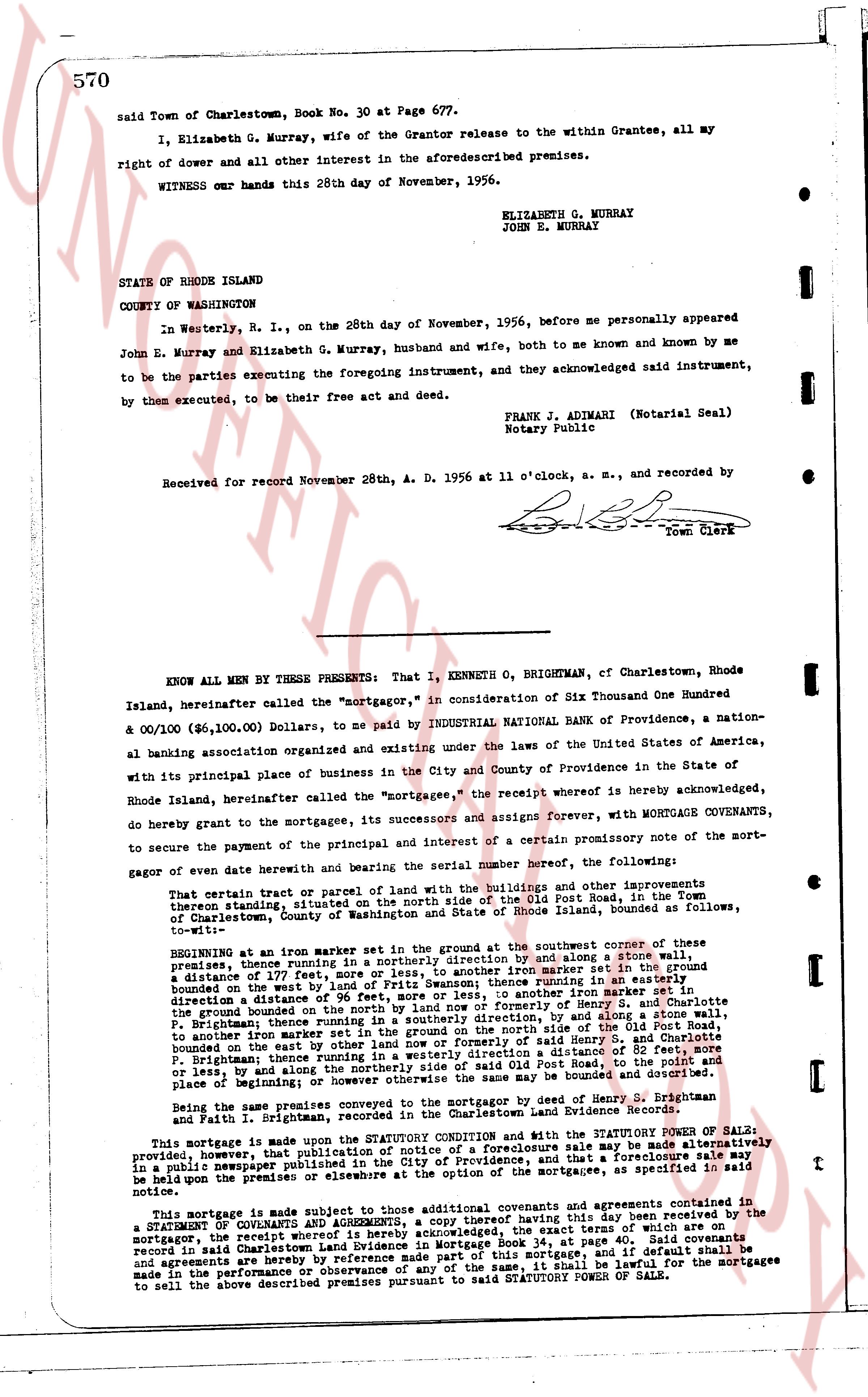
said Town of Charlestown, Book No. 30 at Page 677.
I, Elizabeth G. Murray, wife of the Grantor release to the within Grantee, all my right of dower and all other interest in the aforesaid described premises.
WITNESS our hands this 28th day of November, 1956.
ELIZABETH G. MURRAY
JOHN E. MURRAY
STATE OF RHODE ISLAND
COUNTY OF WASHINGTON
In Westerly, R. I., on the 28th day of November, 1956, before me personally appeared John E. Murray and Elizabeth G. Murray, husband and wife, both to me known and known by me to be the parties executing the foregoing instrument, and they acknowledged said instrument, by them executed, to be their free act and deed.
FRANK J. ADIMARI (Notarial Seal)
Notary Public
Received for record November 28th, A. D. 1956 at 11 o'clock, a. m., and recorded by [signature]
Town Clerk
----
KNOW ALL MEN BY THESE PRESENTS: That I, KENNETH O. BRIGHTMAN, of Charlestown, Rhode Island, hereinafter called the "mortgagor," in consideration of Six Thousand One Hundred & 00/100 ($6,100.00) Dollars, to me paid by INDUSTRIAL NATIONAL BANK of Providence, a national banking association organized and existing under the laws of the United States of America, with its principal place of business in the City and County of Providence in the State of Rhode Island, hereinafter called the "mortgagee," the receipt whereof is hereby acknowledged, do hereby grant to the mortgagee, its successors and assigns forever, with MORTGAGE COVENANTS, to secure the payment of the principal and interest of a certain promissory note of the sort-gagor of even date herewith and bearing the serial number [?] hereof, the following:
That certain tract or parcel of land with the buildings and other improvements thereon standing, situated on the north side of the Old Post Road, in the Town of Charlestown, County of Washington and State of Rhode Island, bounded as follows, namely:
BEGINNING at an iron marker set in the ground at the southwest corner of these premises; thence running in a northerly direction and by a line offset 5 feet, from a distance of 177 feet to another iron marker set in the ground set in the ground bounded on the west by a line of Fritz Swenson; thence running in an easterly direction a distance of 115 feet to another iron marker set in the ground; thence running in a southerly direction a distance of 177 feet to another iron marker set in the ground bounded on the north by former property of Henry S. and Charlotte B. Pitman; thence running in a westerly direction by a line offset 5 feet, and by a line to another iron marker set in the ground on the north side of the Old Post Road, bounded on the east by other land of the mortgagee, and by said road and others, to the beginning; thence running in a westerly direction a distance of 82 feet, more or less, and by other land of the mortgagee, and by said road and others, to the beginning; and along the northerly side of said road to the point of beginning; the boundaries of the premises so far the same may be bounded and described.
Being the same premises conveyed to the mortgagor by the deed of Henry S. Brightman and Faith I. Brightman, recorded in the Charlestown Land Evidence Record [?].
This mortgage is made upon the STATUTORY CONDITION and with the STATUTORY POWER OF SALE; provided, however, that public notice of any sale made hereunder may be made alternatively in a public newspaper published in the City of Providence, and that a foreclosure sale may be held upon the premises or elsewhere at the discretion of the mortgagee or its successors in interest.
This MORTGAGE is made subject to the contractual covenants and agreements set forth in a STATEMENT OF COVENANTS AND AGREEMENTS, a copy thereof having been this day received by the mortgagor, the receipt whereof is hereby acknowledged, the exact terms of which are recorded in said Charlestown Land Evidence in Mortgage Book 34, at page 00. The covenants and agreements are incorporated by reference into this mortgage, and if default shall be made in the performance or observance of any of the same, it shall be lawful for the mortgagee to sell the above described premises pursuant to said STATUTORY POWER OF SALE.
The page as recorded