The instrument's own words
page 1 · read by Gemma vision
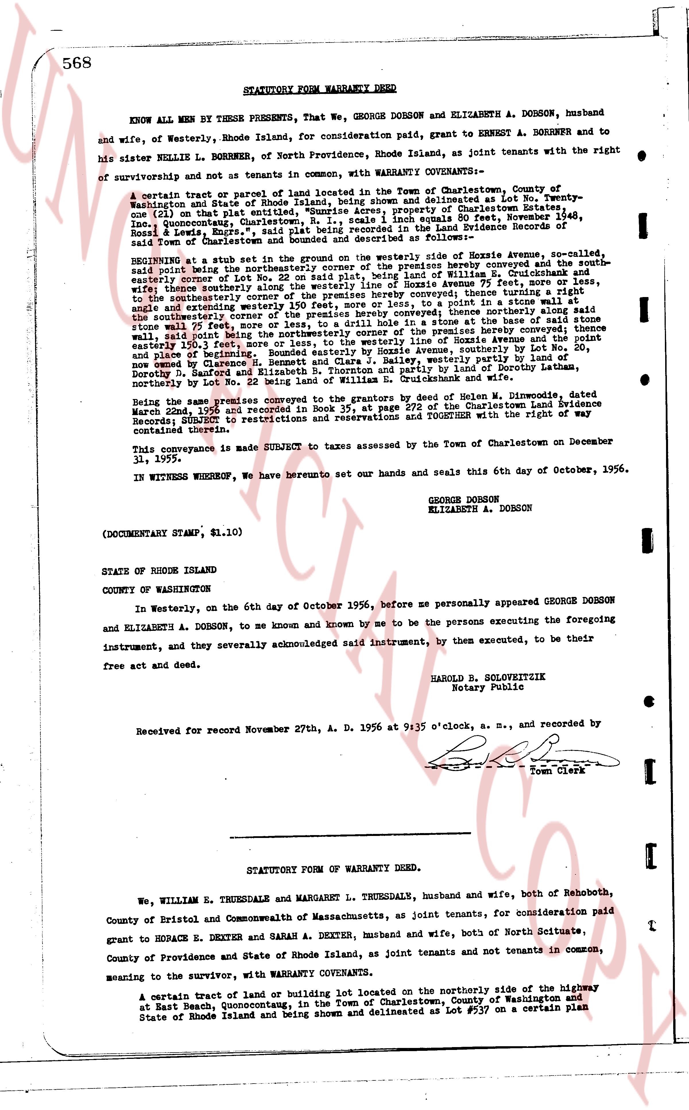
568 STATUTORY FORM WARRANTY DEED
KNOW ALL MEN BY THESE PRESENTS, That We, GEORGE DORSON and ELIZABETH A. DORSON, husband and wife, of Westerly, Rhode Island, for consideration paid, grant to ERNEST A. BORRNER and to his sister NELLIE L. BORRNER, of North Providence, Rhode Island, as joint tenants with the right of survivorship and not as tenants in common, with WARRANTY COVENANTS:—
A certain tract of parcel or parcel of land located in the Town of Charlestown, County of Washington and State of Rhode Island, being shown and delineated as Lot # 10 on a certain plan (see page 60) in that part called Quonochontaug, being the property of Charlestown Estates, Inc., Quonochontaug, Charlestown, R. I., scale 1 inch equals 80 feet, November 20, 1948, recorded in the land Evidence books of the Town of Charlestown as follows: Book 25, page 503, Ross & Lewis, Engrs., and described as follows:—
BEGINNING at a stub set in the ground on the westerly side of Seaside Avenue, sr-called, the said stub being the northeasterly corner of a lot being land of William E. Cruickshank and wife; thence southerly along the northeasterly side of Seaside Avenue 77 feet, more or less, to the southeasterly corner of a lot being land of William E. Cruickshank and wife; thence southerly along the westerly line of the said lot 250 feet, more or less, to the southeasterly corner of a lot being land of the above conveyed; thence turning a right angle and extending westerly 250 feet, more or less, to a point in a line running parallel to the southeasterly line of the above conveyed lot; thence northerly along said line to the northeasterly corner of a lot being land of the above conveyed; thence northerly along said line to the northeasterly corner of a lot being land of the above conveyed; thence northerly along said stone wall 75 feet, more or less, to a drill hole in a stone at the base of said stone wall, which mark is the northeasterly corner of the above conveyed lot; thence easterly 150.3 feet, more or less, to the westerly line of Roxbury Avenue and the point of beginning.
Being the same premises conveyed to the grantors by deed of Helen H. Dimond, dated March 22nd 1950 and recorded book 35, at page 272 of the Charlestown land Evidence Records, SUBJECT to restrictions and reservations and TOGETHER with the right of way contained therein.
This conveyance is made SUBJECT to taxes assessed by the Town of Charlestown on December 31, 1955.
IN WITNESS WHEREOF, We hereunto set our hands and seals this 6th day of October, 1956.
GEORGE DORSON
ELIZABETH A. DORSON
(DOCUMENTARY STAMP, $1.10)
STATE OF RHODE ISLAND
COUNTY OF WASHINGTON
In Westerly, on the 6th day of October 1956, before me personally appeared GEORGE DORSON and ELIZABETH A. DORSON, to me and known by me to be the persons executing the foregoing instrument, and they severally acknowledged said instrument, by them executed, to be their free act and deed.
HAROLD B. SOLOBEWITZ
Notary Public
Received for record November 27th, A. D. 1956 at 9:35 o'clock, a. m., and recorded by [Signature]
Town Clerk
----
STATUTORY FORM OF WARRANTY DEED.
We, WILLIAM E. TRUESDALE and MARGARET L. TRUESDALE, husband and wife, both of Rehoboth, County of Bristol and Commonwealth of Massachusetts, as joint tenants, for consideration paid grant to HORACE E. DEXTER and SARAH A. DEXTER, husband and wife, both of North Scituate, County of Providence and State of Rhode Island, as joint tenants and not tenants in common, meaning to the survivor, with WARRANTY COVENANTS.
A certain tract of land or being lot 1 located on the northerly side of the highway at East Beach, Quonochontaug, in the Town of Charlestown, County of Washington and State of Rhode Island and being shown and delineated as Lot # 537 on a certain plan
page 2 · read by Gemma vision
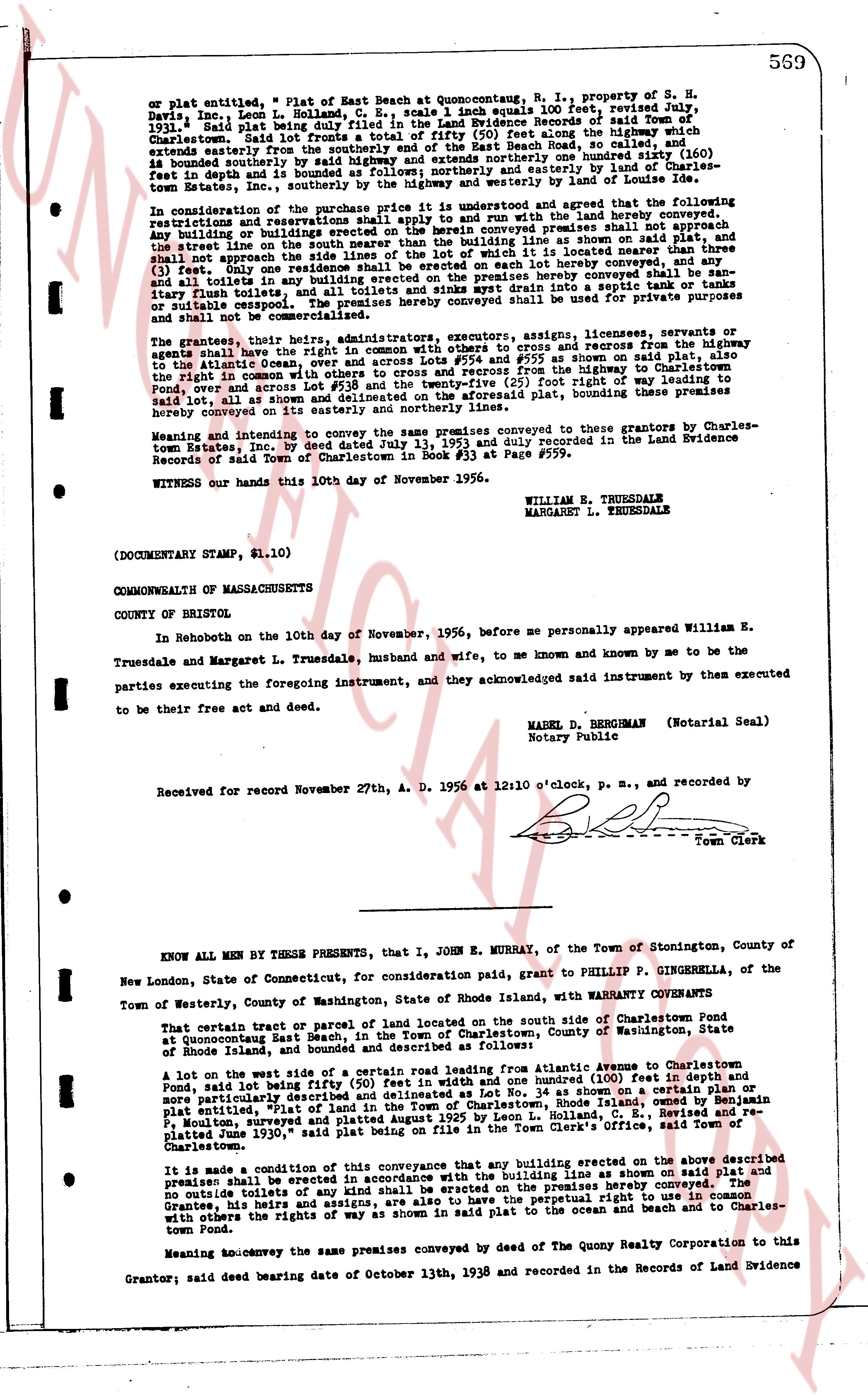
569
on plat entitled, " Plat of East Beach at Quonsetpoint, R. I., property of S. H.
Davis, Inc." Leon L. Holland, C. E., scale 1 inch equals 100 feet, revised July,
1931," said Plat being duly filed in the Land Evidence Books of said Town of
Charlestown. Said lot extends from the easterly boundary of the highway 187 feet along the highway,
extending easterly from the intersection of said highway and the East Boundary of the Beach Road, so
long as the depth and is 100 feet in depth and is 100 feet wide, and is bounded easterly and
(100) bounded southerly by said highway and extends southerly one hundred feet (100) and is bounded
(100) easterly by the land of Charles-
town Estates, Inc., southerly by the highway and westerly by the land of Lot number 34.
In consideration of the purchase price the grantor and grantee agreed that the following
restrictions forever shall run with the land and be binding on the land hereby conveyed:
any building or buildings erected on the herein conveyed premises shall not approach
the street line to within twenty-five (25) feet, and shall be set back from the plat, and the
shall not approach the side lines of the lot with it located no nearer than three
(3) feet. Any and all toilets and any building on the premises hereby conveyed shall be san-
or stable’s’’’’’’’’’’’’’’’’’’’’’’’’’’’’’’’’’’’’’’’’’’’’’’’’’’’’’’’’’’’’’’’’’’’’’’’’’’’’’’’’’’’’’’’’’’’’’’’’’’’’’’’’’’’’’’’’’’’’’’’’’’’’’’’’’’’’’’’’’’’’’’’’’’’’’’’’’’’’’’’’’’’’’’’’’’’’’’’’’’’’’’’’’’’’’’’’’’’’’’’’’’’’’’’’’’’’’’’’’’’’’’’’’’’’’’’’’’’’’’’’’’’’’’’’’’’’’’’’’’’’’’’’’’’’’’’’’’’’’’’’’’’’’’’’’’’’’’’’’’’’’’’’’’’’’’’’’’’’’’’’’’’’’’’’’’’’’’’’’’’’’’’’’’’’’’’’’’’’’’’’’’’’’’’’’’’’’’’’’’’’’’’’’’’’’’’’’’’’’’’’’’’’’’’’’’’’’’’’’’’’’’’’’’’’’’’’’’’’’’’’’’’’’’’’’’’’’’’’’’’’’’’’’’’’’’’’’’’’’’’’’’’’’’’’’’’’’’’’’’’’’’’’’’’’’’’’’’’’’’’’’’’’’’’’’’’’’’’’’’’’’’’’’’’’’’’’’’’’’’’’’’’’’’’’’’’’’’’’’’’’’’’’’’’’’’’’’’’’’’’’’’’’’’’’’’’’’’’’’’’’’’’’’’’’’’’’’’’’’’’’’’’’’’’’’’’’’’’’’’’’’’’’’’’’’’’’’’’’’’’’’’’’’’’’’’’’’’’’’’’’’’’’’’’’’’’’’’’’’’’’’’’’’’’’’’’’’’’’’’’’’’’’’’’’’’’’’’’’’’’’’’’’’’’’’’’’’’’’’’’’’’’’’’’’’’’’’’’’’’’’’’’’’’’’’’’’’’’’’’’’’’’’’’’’’’’’’’’’’’’’’’’’’’’’’’’’’’’’’’’’’’’’’’’’’’’’’’’’’’’’’’’’’’’’’’’’’’’’’’’’’’’’’’’’’’’’’’’’’’’’’’’’’’’’’’’’’’’’’’’’’’’’’’’’’’’’’’’’’’’’’’’’’’’’’’’’’’’’’’’’’’’’’’’’’’’’’’’’’’’’’’’’’’’’’’’’’’’’’’’’’’’’’’’’’’’’’’’’’’’’’’’’’’’’’’’’’’’’’’’’’’’’’’’’’’’’’’’’’’’’’’’’’’’’’’’’’’’’’’’’’’’’’’’’’’’’’’’’’’’’’’’’’’’’’’’’’’’’’’’’’’’’’’’’’’’’’’’’’’’’’’’’’’’’’’’’’’’’’’’’’’’’’’’’’’’’’’’’’’’’’’’’’’’’’’’’’’’’’’’’’’’’’’’’’’’’’’’’’’’’’’’’’’’’’’’’’’’’’’’’’’’’’’’’’’’’’’’’’’’’’’’’’’’’’’’’’’’’’’’’’’’’’’’’’’’’’’’’’’’’’’’’’’’’’’’’’’’’’’’’’’’’’’’’’’’’’’’’’’’’’’’’’’’’’’’’’’’’’’’’’’’’’’’’’’’’’’’’’’’’’’’’’’’’’’’’’’’’’’’’’’’’’’’’’’’’’’’’’’’’’’’’’’’’’’’’’’’’’’’’’’’’’’’’’’’’’’’’’’’’’’’’’’’’’’’’’’’’’’’’’’’’’’’’’’’’’’’’’’’’’’’’’’’’’’’’’’’’’’’’’’’’’’’’’’’’’’’’’’’’’’’’’’’’’’’’’’’’’’’’’’’’’’’’’’’’’’’’’’’’’’’’’’’’’’’’’’’’’’’’’’’’’’’’’’’’’’’’’’’’’’’’’’’’’’’’’’’’’’’’’’’’’’’’’’’’’’’’’’’’’’’’’’’’’’’’’’’’’’’’’’’’’’’’’’’’’’’’’’’’’’’’’’’’’’’’’’’’’’’’’’’’’’’’’’’’’’’’’’’’’’’’’’’’’’’’’’’’’’’’’’’’’’’’’’’’’’’’’’’’’’’’’’’’’’’’’’’’’’’’’’’’’’’’’’’’’’’’’’’’’’’’’’’’’’’’’’’’’’’’’’’’’’’’’’’’’’’’’’’’’’’’’’’’’’’’’’’’’’’’’’’’’’’’’’’’’’’’’’’’’’’’’’’’’’’’’’’’’’’’’’’’’’’’’’’’’’’’’’’’’’’’’’’’’’’’’’’’’’’’’’’’’’’’’’’’’’’’’’’’’’’’’’’’’’’’’’’’’’’’’’’’’’’’’’’’’’’’’’’’’’’’’’’’’’’’’’’’’’’’’’’’’’’’’’’’’’’’’’’’’’’’’’’’’’’’’’’’’’’’’’’’’’’’’’’’’’’’’’’’’’’’’’’’’’’’’’’’’’’’’’’’’’’’’’’’’’’’’’’’’’’’’’’’’’’’’’’’’’’’’’’’’’’’’’’’’’’’’’’’’’’’’’’’’’’’’’’’’’’’’’’’’’’’’’’’’’’’’’’’’’’’’’’’’’’’’’’’’’’’’’’’’’’’’’’’’’’’’’’’’’’’’’’’’’’’’’’’’’’’’’’’’’’’’’’’’’’’’’’’’’’’’’’’’’’’’’’’’’’’’’’’’’’’’’’’’’’’’’’’’’’’’’’’’’’’’’’’’’’’’’’’’’’’’’’’’’’’’’’’’’’’’’’’’’’’’’’’’’’’’’’’’’’’’’’’’’’’’’’’’’’’’’’’’’’’’’’’’’’’’’’’’’’’’’’’’’’’’’’’’’’’’’’’’’’’’’’’’’’’’’’’’’’’’’’’’’’’’’’’’’’’’’’’’’’’’’’’’’’’’’’’’’’’’’’’’’’’’’’’’’’’’’’’’’’’’’’’’’’’’’’’’’’’’’’’’’’’’’’’’’’’’’’’’’’’’’’’’’’’’’’’’’’’’’’’’’’’’’’’’’’’’’’’’’’’’’’’’’’’’’’’’’’’’’
The page as recorded