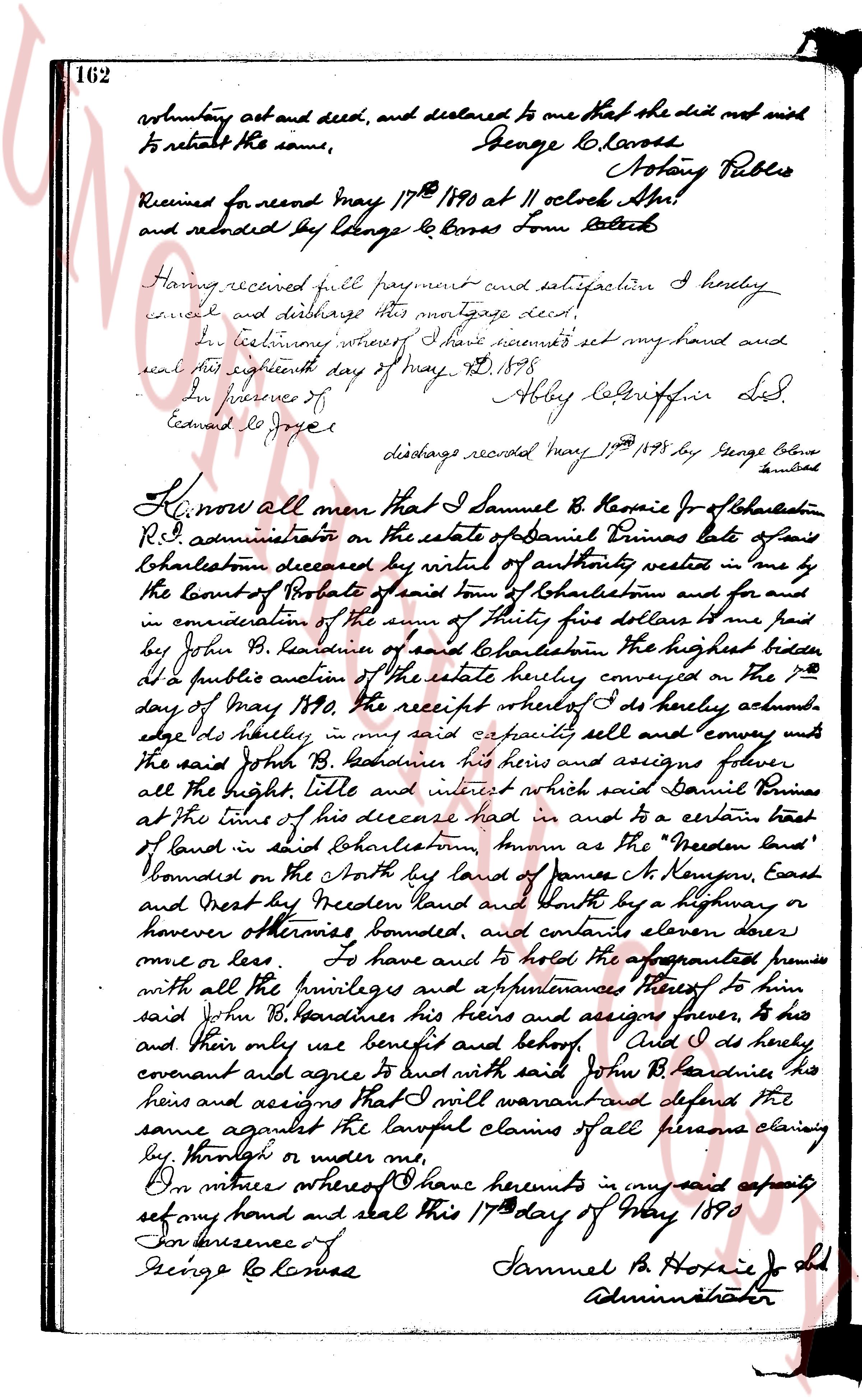
The instrument's own words
page 1
162
voluntary act and deed, and declared to me that she did not wish
to retract the same,
George L. Barnes
Notary Public
Received for record May 17th 1890 at 11 oclock A.M.
and recorded by George L. Barnes Town Clerk
Having received full payment and satisfaction I hereby
cancel and discharge this mortgage deed.
In testimony whereof I have executed my hand and
seal this eighteenth day of May AD 1878
In presence of
Edward Joyce
Abby Lebrunne[illegible] Ldr
discharge recorded May 1st 1878 by George Barnes
Clerk
Know all men that I Samuel B. Hoxie Jr of Charleston
R.I. administrator on the estate of Daniel Brines late of same
Charleston deceased by virtue of authority vested in me by
the Court of Probate of said town of Charleston and for me
in consideration of the sum of thirty five dollars one paid
by John B. Beaudines of said Charleston the highest bidder
at a public auction of the estate hereby convey to the 7th
day of May 1890 the receipt whereof I do hereby acknowledge in his hereby in my said capacity sell and convey unto
the said John B. Beaudines his heirs and assigns forever
all the right title and interest which said Daniel Brines
at the time of his decease had in and to a certain tract
of land in said Charleston known as the "Freedom land"
Bounded on the North by land of James N. Kenyon, East
and West by the Freedom Land and North by a highway or
however otherwise bounded, and contains eleven acres
more or less To have and to hold the aforementioned premises
with all the privileges and appurtenances thereof to his
said John B. Beaudines his heirs and assigns forever, to his
and their only use benefit and behalf And I do hereby
covenant and agree to land with said John B. Beaudines his
heirs and assigns that I will warrant and defend the
same against the lawful claims of all persons claiming
by through or under me.
In witness whereof I have hereunto in my said capacity
set my hand and seal this 17th day of May 1890
In presence of
George L. Barnes
Samuel B. Hoxie Jr Ad
Administrator
page 2
546
STATE OF RHODE ISLAND
COUNTY OF WASHINGTON
In Charlestown, this 17th day of November, A. D. 1956, personally appeared said William
D. Cross, Collector as aforesaid, to me known and known by me to be the party executing the
foregoing instrument, and acknowledged the above instrument by his signed and sealed to be his
free act and deed in said his said capacity.
Before me
JAMES O. WATTS
Notary Public
AFFIDAVIT
I, William D. Cross, Collector as above said for the Town of Charlestown, on oath depose
and say that the facts stated in the aforesaid deed are true.
WILLIAM D. CROSS
Collector of Taxes for the Town of
Charlestown.
Subscribed and sworn to this 17th day of November
A. D. 1956.
Before me
JAMES O. WATTS
Notary Public
TOWN OF CHARLESTOWN
Tax Collector's
Sale
Legal Advertising to
Tax Collector's
Sale
The subscribers, Collector of Taxes for the Town of Charlestown, County of Washington, State of Rhode Island, hereby give notice that they will sell at public auction, to the highest bidder, for cash, the following described real estate and tangible personal property, situated in the Town of Charlestown, County of Washington, State of Rhode Island, which has been seized for nonpayment of taxes, and will be sold on the 1st day of December, A. D. 1956, at 10 o'clock r.m., at the lock block room, south installations on all the real estate and tangible personal property, and the rettable intangible personal property in the Town of Charlestown, County of Washington, State of Rhode Island, as follows:
Lot No. 1, containing 1/2 acre, bounded on the North by Lot No. 2, on the East by the road, on the South by Lot No. 3, and on the West by the road.
Lot No. 2, containing 1/2 acre, bounded on the North by Lot No. 4, on the East by the road, on the South by Lot No. 1, and on the West by the road.
Lot No. 3, containing 1/2 acre, bounded on the North by Lot No. 1, on the East by the road, on the South by Lot No. 5, and on the West by the road.
Lot No. 4, containing 1/2 acre, bounded on the North by Lot No. 6, on the East by the road, on the South by Lot No. 2, and on the West by the road.
Lot No. 5, containing 1/2 acre, bounded on the North by Lot No. 3, on the East by the road, on the South by Lot No. 7, and on the West by the road.
Lot No. 6, containing 1/2 acre, bounded on the North by Lot No. 8, on the East by the road, on the South by Lot No. 4, and on the West by the road.
Lot No. 7, containing 1/2 acre, bounded on the North by Lot No. 5, on the East by the road, on the South by Lot No. 9, and on the West by the road.
Lot No. 8, containing 1/2 acre, bounded on the North by Lot No. 10, on the East by the road, on the South by Lot No. 6, and on the West by the road.
Lot No. 9, containing 1/2 acre, bounded on the North by Lot No. 7, on the East by the road, on the South by Lot No. 11, and on the West by the road.
Lot No. 10, containing 1/2 acre, bounded on the North by Lot No. 12, on the East by the road, on the South by Lot No. 8, and on the West by the road.
Lot No. 11, containing 1/2 acre, bounded on the North by Lot No. 9, on the East by the road, on the South by Lot No. 13, and on the West by the road.
Lot No. 12, containing 1/2 acre, bounded on the North by Lot No. 14, on the East by the road, on the South by Lot No. 10, and on the West by the road.
Lot No. 13, containing 1/2 acre, bounded on the North by Lot No. 11, on the East by the road, on the South by Lot No. 15, and on the West by the road.
Lot No. 14, containing 1/2 acre, bounded on the North by Lot No. 16, on the East by the road, on the South by Lot No. 12, and on the West by the road.
Lot No. 15, containing 1/2 acre, bounded on the North by Lot No. 13, on the East by the road, on the South by Lot No. 17, and on the West by the road.
Lot No. 16, containing 1/2 acre, bounded on the North by Lot No. 18, on the East by the road, on the South by Lot No. 14, and on the West by the road.
Lot No. 17, containing 1/2 acre, bounded on the North by Lot No. 15, on the East by the road, on the South by Lot No. 19, and on the West by the road.
Lot No. 18, containing 1/2 acre, bounded on the North by Lot No. 20, on the East by the road, on the South by Lot No. 16, and on the West by the road.
Lot No. 19, containing 1/2 acre, bounded on the North by Lot No. 17, on the East by the road, on the South by Lot No. 21, and on the West by the road.
Lot No. 20, containing 1/2 acre, bounded on the North by Lot No. 22, on the East by the road, on the South by Lot No. 18, and on the West by the road.
Lot No. 21, containing 1/2 acre, bounded on the North by Lot No. 19, on the East by the road, on the South by Lot No. 23, and on the West by the road.
Lot No. 22, containing 1/2 acre, bounded on the North by Lot No. 24, on the East by the road, on the South by Lot No. 20, and on the West by the road.
Lot No. 23, containing 1/2 acre, bounded on the North by Lot No. 21, on the East by the road, on the South by Lot No. 25, and on the West by the road.
Lot No. 24, containing 1/2 acre, bounded on the North by Lot No. 26, on the East by the road, on the South by Lot No. 22, and on the West by the road.
Lot No. 25, containing 1/2 acre, bounded on the North by Lot No. 23, on the East by the road, on the South by Lot No. 27, and on the West by the road.
Lot No. 26, containing 1/2 acre, bounded on the North by Lot No. 28, on the East by the road, on the South by Lot No. 24, and on the West by the road.
Lot No. 27, containing 1/2 acre, bounded on the North by Lot No. 25, on the East by the road, on the South by Lot No. 29, and on the West by the road.
Lot No. 28, containing 1/2 acre, bounded on the North by Lot No. 30, on the East by the road, on the South by Lot No. 26, and on the West by the road.
Lot No. 29, containing 1/2 acre, bounded on the North by Lot No. 27, on the East by the road, on the South by Lot No. 31, and on the West by the road.
Lot No. 30, containing 1/2 acre, bounded on the North by Lot No. 32, on the East by the road, on the South by Lot No. 28, and on the West by the road.
Lot No. 31, containing 1/2 acre, bounded on the North by Lot No. 29, on the East by the road, on the South by Lot No. 33, and on the West by the road.
Lot No. 32, containing 1/2 acre, bounded on the North by Lot No. 34, on the East by the road, on the South by Lot No. 30, and on the West by the road.
Lot No. 33, containing 1/2 acre, bounded on the North by Lot No. 31, on the East by the road, on the South by Lot No. 35, and on the West by the road.
Lot No. 34, containing 1/2 acre, bounded on the North by Lot No. 36, on the East by the road, on the South by Lot No. 32, and on the West by the road.
Lot No. 35, containing 1/2 acre, bounded on the North by Lot No. 33, on the East by the road, on the South by Lot No. 37, and on the West by the road.
Lot No. 36, containing 1/2 acre, bounded on the North by Lot No. 38, on the East by the road, on the South by Lot No. 34, and on the West by the road.
Lot No. 37, containing 1/2 acre, bounded on the North by Lot No. 35, on the East by the road, on the South by Lot No. 39, and on the West by the road.
Lot No. 38, containing 1/2 acre, bounded on the North by Lot No. 40, on the East by the road, on the South by Lot No. 36, and on the West by the road.
Lot No. 39, containing 1/2 acre, bounded on the North by Lot No. 37, on the East by the road, on the South by Lot No. 41, and on the West by the road.
Lot No. 40, containing 1/2 acre, bounded on the North by Lot No. 42, on the East by the road, on the South by Lot No. 38, and on the West by the road.
Lot No. 41, containing 1/2 acre, bounded on the North by Lot No. 39, on the East by the road, on the South by Lot No. 43, and on the West by the road.
Lot No. 42, containing 1/2 acre, bounded on the North by Lot No. 44, on the East by the road, on the South by Lot No. 40, and on the West by the road.
Lot No. 43, containing 1/2 acre, bounded on the North by Lot No. 41, on the East by the road, on the South by Lot No. 45, and on the West by the road.
Lot No. 44, containing 1/2 acre, bounded on the North by Lot No. 46, on the East by the road, on the South by Lot No. 42, and on the West by the road.
Lot No. 45, containing 1/2 acre, bounded on the North by Lot No. 43, on the East by the road, on the South by Lot No. 47, and on the West by the road.
Lot No. 46, containing 1/2 acre, bounded on the North by Lot No. 48, on the East by the road, on the South by Lot No. 44, and on the West by the road.
Lot No. 47, containing 1/2 acre, bounded on the North by Lot No. 45, on the East by the road, on the South by Lot No. 49, and on the West by the road.
Lot No. 48, containing 1/2 acre, bounded on the North by Lot No. 50, on the East by the road, on the South by Lot No. 46, and on the West by the road.
Lot No. 49, containing 1/2 acre, bounded on the North by Lot No. 47, on the East by the road, on the South by Lot No. 51, and on the West by the road.
Lot No. 50, containing 1/2 acre, bounded on the North by Lot No. 52, on the East by the road, on the South by Lot No. 48, and on the West by the road.
Lot No. 51, containing 1/2 acre, bounded on the North by Lot No. 49, on the East by the road, on the South by Lot No. 53, and on the West by the road.
Lot No. 52, containing 1/2 acre, bounded on the North by Lot No. 54, on the East by the road, on the South by Lot No. 50, and on the West by the road.
Lot No. 53, containing 1/2 acre, bounded on the North by Lot No. 51, on the East by the road, on the South by Lot No. 55, and on the West by the road.
Lot No. 54, containing 1/2 acre, bounded on the North by Lot No. 56, on the East by the road,
The page as recorded