The instrument's own words
page 1 · read by Gemma vision
525
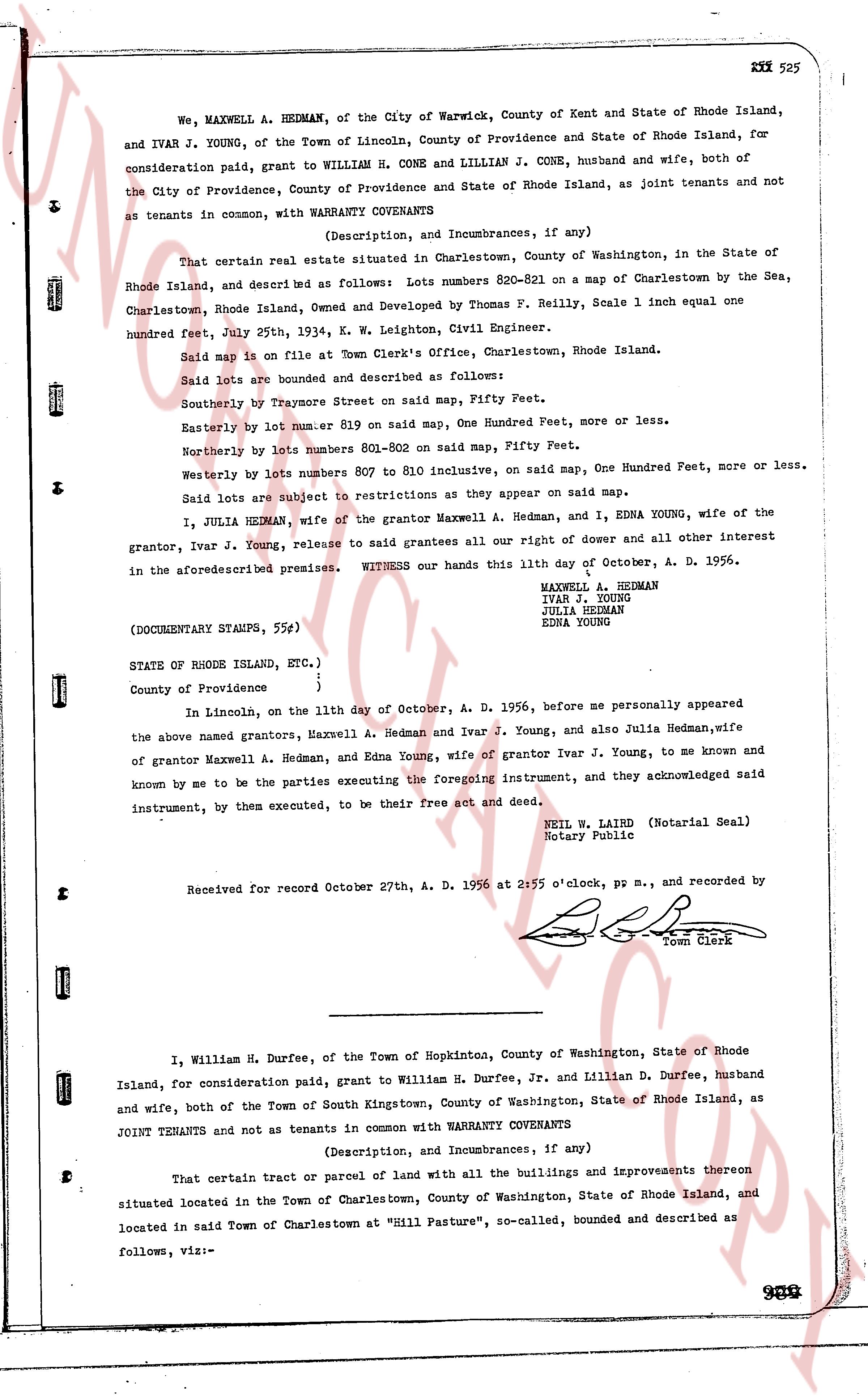
We, MAXWELL A. HEDMAN, of the City of Warwick, County of Kent and State of Rhode Island, and IVAR J. YOUNG, of the Town of Lincoln, County of Providence and State of Rhode Island, for consideration paid, grant to WILLIAM H. CONE and LILLIAN J. CONE, husband and wife, both of the City of Providence, County of Providence and State of Rhode Island, as joint tenants and not as tenants in common, with WARRANTY COVENANTS
(Description, and Incumbrances, if any)
That certain real estate situated in Charlestown, County of Washington, in the State of Rhode Island, and described as follows: Lots numbers 820-821 on a map of Charlestown by the Sea, Charlestown, Rhode Island, Owned and Developed by Thomas F. Reilly, Scale 1 inch equal one hundred feet, July 25th, 1934, K. W. Leighton, Civil Engineer.
Said map is on file at Town Clerk's Office, Charlestown, Rhode Island.
Said lots are bounded and described as follows:
Southerly by Traysore Street on said map, Fifty Feet.
Easterly by lot number 819 on said map, One Hundred Feet, more or less.
Northerly by lots numbers 801-802 on said map, Fifty Feet.
Westerly by lots numbers 807 to 810 inclusive, on said map, One Hundred Feet, more or less.
Said lots are subject to restrictions as they appear on said map.
I, JULIA HEDMAN, wife of the grantor Maxwell A. Hedman, and I, EDNA YOUNG, wife of the grantor, Ivar J. Young, release to said grantees all our right of dower and all other interest in the aforementioned premises. WITNESS our hands this 11th day of October, A. D. 1956.
MAXWELL A. HEDMAN
IVAR J. YOUNG
JULIA HEDMAN
EDNA YOUNG
(DOCUMENTARY STAMPS, 55¢)
STATE OF RHODE ISLAND, ETC.)
)
County of Providence )
In Lincoln, on the 11th day of October, A. D. 1956, before me personally appeared the above named grantors, Maxwell A. Hedman and Ivar J. Young, and also Julia Hedman,wife of grantor Maxwell A. Hedman, and Edna Young, wife of grantor Ivar J. Young, to me known and known by me to be the parties executing the foregoing instrument, and they acknowledged said instrument, by them executed, to be their free act and deed.
NEIL W. LAIRD (Notarial Seal)
Notary Public
Received for record October 27th, A. D. 1956 at 2:55 o'clock, pp m., and recorded by [?]
Town Clerk
----
I, William H. Durfee, of the Town of Hopkinton, County of Washington, State of Rhode Island, for consideration paid, grant to William H. Durfee, Jr. and Lillian D. Durfee, husband and wife, both of the Town of South Kingstown, County of Washington, State of Rhode Island, as JOINT TENANTS and not as tenants in common with WARRANTY COVENANTS
(Description, and Incumbrances, if any)
That certain tract or parcel of land with all the buildings and improvements thereon situated located in the Town of Charlestown, County of Washington, State of Rhode Island, and located in said Town of Charlestown at "Hill Pasture", so-called, bounded and described as follows, viz:-
page 2 · read by Gemma vision
526
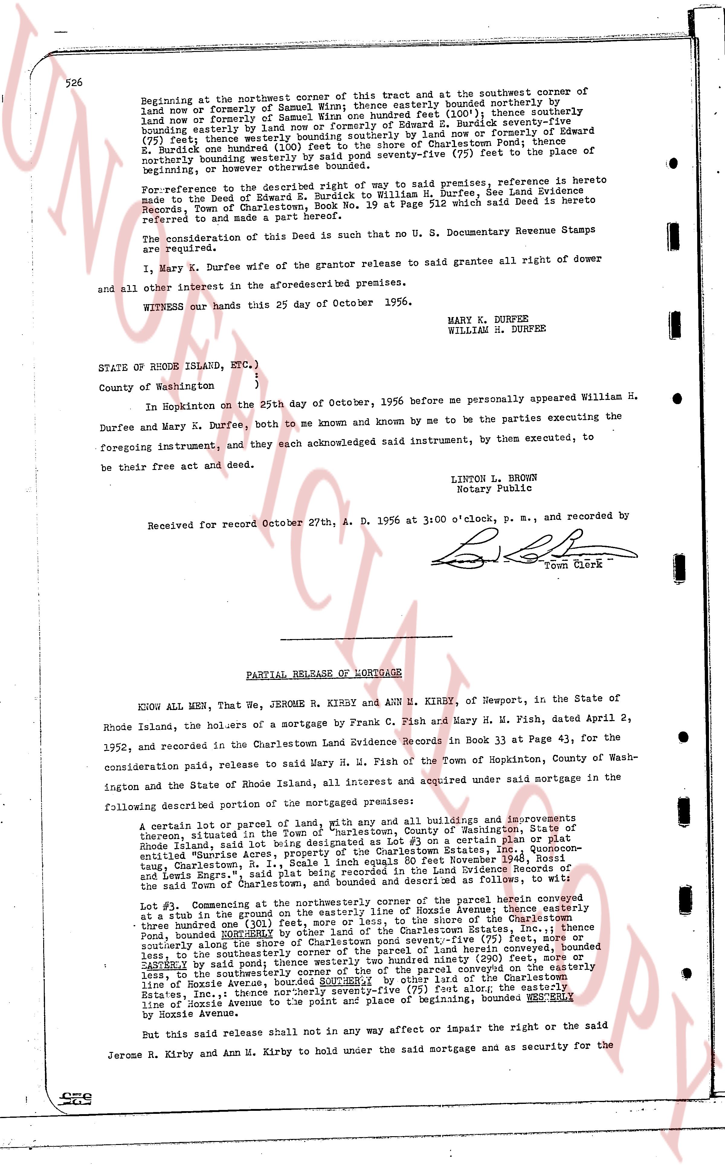
Beginning at the northwest corner of this tract and at the southwest corner of land now or formerly of Samuel Wirn; thence easterly bounded northerly by land now or formerly of Samuel Wirn; thence southerly bounded northerly by land now or formerly of Samuel Wirn; thence southerly bounded easterly by land now or formerly of Edward E. Burdick seventy-five (75) feet; thence westerly bounded southerly by land now or formerly of Edward E. Burdick and bounded westerly by the road to Charlestown Pond, thence northerly bounded westerly by said pond seventy-five (75) feet to the place of beginning, now otherwise known as Lot #3.
For reference to the General Deed giving right of way to said premises, reference is here made to the Deed of Edward E. Burdick to William H. Durfee, See Land Evidence Records, Town of Charlestown, Book No. 19 at Page 512 which said Deed is hereto referred to and made a part hereof.
The consideration of this Deed is such that no U. S. Documentary Revenue Stamps are required.
I, Mary K. Durfee wife of the grantor release to said grantee all right of dower and all other interest in the aforesaid described premises.
WITNESS our hands this 25 day of October 1956.
MARY K. DURFEE
WILLIAM H. DURFEE
STATE OF RHODE ISLAND, ETC.)
)
)
County of Washington )
In Hopkinton on the 25th day of October, 1956 before me personally appeared William H. Durfee and Mary K. Durfee, both to me known and known by me to be the parties executing the foregoing instrument, and they each acknowledged said instrument, by them executed, to be their free act and deed.
LINTON L. BROWN
Notary Public
Received for record October 27th, A. D. 1956 at 3:00 o'clock, p. m., and recorded by [signature] Town Clerk
----
PARTIAL RELEASE OF MORTGAGE
KNOW ALL MEN, That We, JEROME H. KIRBY and ANN M. KIRBY, of Newport, in the State of Rhode Island, the holders of a mortgage by Frank C. Fish and Mary H. M. Fish, dated April 2, 1952, and recorded in the Charlestown Land Evidence Records in Book 33 at Page 43, for the consideration paid, release to said Mary H. M. Fish of the Town of Hopkinton, County of Washington in the State of Rhode Island, all interest and acquired under said mortgage in the following described portion of the mortgaged premises:
A certain lot or parcel of lands, with any and all buildings and improvements thereon, situated in the Town of Hopkinton, County of Washington, State of Rhode Island, said lot being designated as Lot #3 on a certain plat of the so-called "Sunrise Acre" located between East and West Main Streets, in the Town of Hopkinton, said plat being Scale 1 inch equals 80 feet Executed November 1942, Rhode Island, Charlestown R. I., said plat being recorded among the Land Evidence Records of the said Town of Charlestown and bounded and described as follows, to wit:
Lot #3: Commencing at the northwesterly corner of the parcel herein conveyed at a stub in the ground on the easterly line of Hoxie Avenue, thence southerly along the shore of the Charlestown Pond, bounded southerly by other land of the Charlestown Estates, Inc.; thence southerly along the easterly line of Hoxie Avenue seventy-five (75) feet, or more or less, to the southeasterly corner of the parcel of land herein conveyed, bounded southeasterly by said pond one hundred and ninety (190) feet, more or less, to the southwesterly corner of the parcel of land conveyed on the easterly line of Hoxie Avenue, thence northerly seventy-five (75) feet along the easterly line of the Charlestown Estates, Inc.; thence northerly seventy-five (75) feet along; the easterly line of Hoxie Avenue to the point and place of beginning, bounded WESTERLY line of Hoxie Avenue.
But this said release shall not in any way affect or impair the right or the said Jerome H. Kirby and Ann M. Kirby to hold under the said mortgage and as security for the
529
The page as recorded