The instrument's own words
page 1 · read by Gemma vision
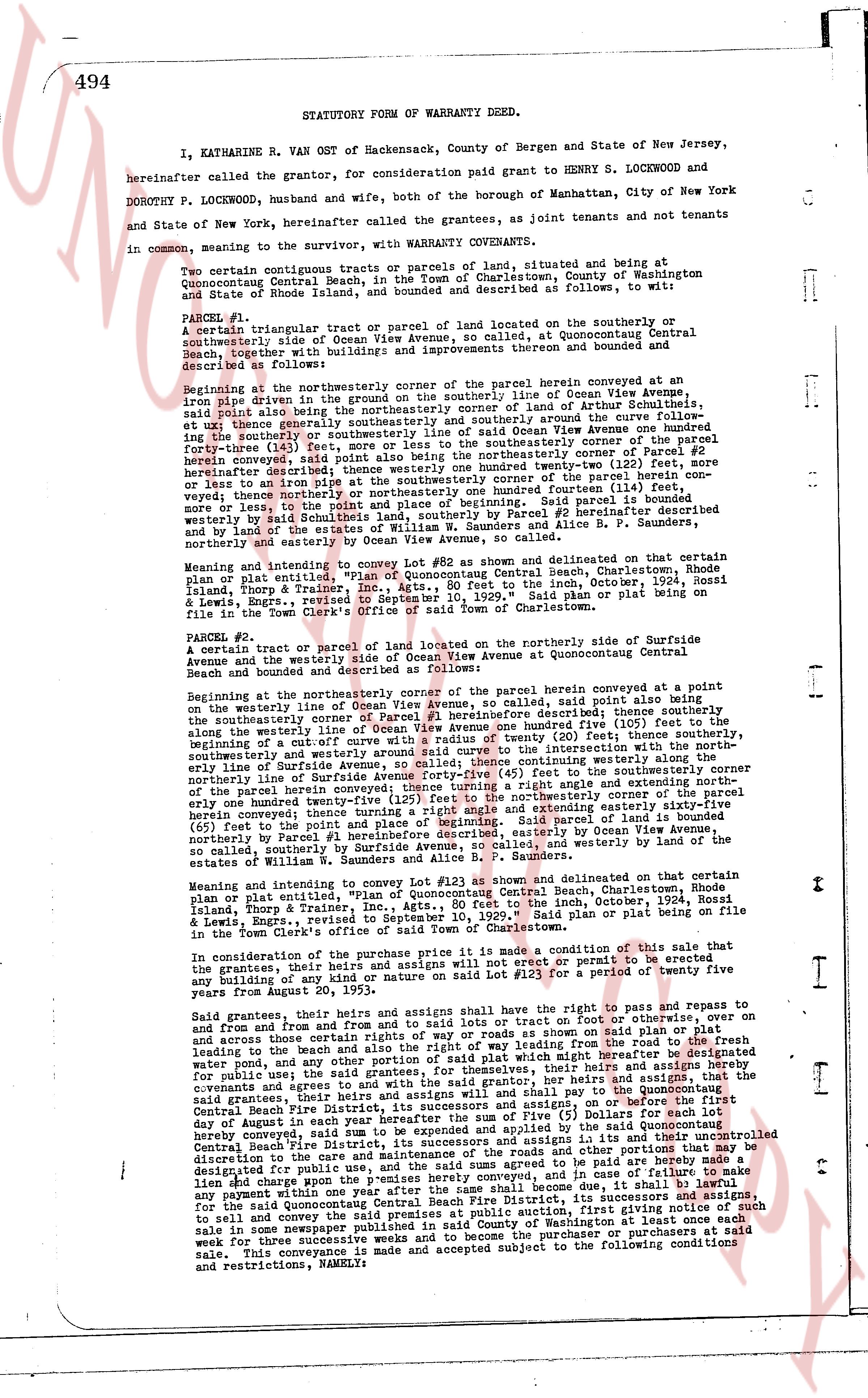
494 STATUTORY FORM OF WARRANTY DEED.
I, KATHARINE R. VAN OST of Hackensack, County of Bergen and State of New Jersey, hereinafter called the grantor, for consideration paid grant to HENRY S. LOCKWOOD and DOROTHY P. LOCKWOOD, husband and wife, both of the borough of Manhattan, City of New York and State of New York, hereinafter called the grantees, as joint tenants and not tenants in common, meaning to the survivor, with WARRANTY COVENANTS.
Two certain contiguous tracts or parcels of land, situated and being at Quonocutong Central Beach, in the Town of Charlestown, County of Washington and State of Rhode Island, and bounded and described as follows, to wit:
PARCEL #1:
A triangular tract or parcel of land located on the southerly or southeasterly side of Ocean View Avenue, so called, at Quonocutong Central Beach, together with the rights, privileges, appurtenances thereunto hered and bounded and described as follows:
Beginning at the northeasterly corner of the parcel herein conveyed at an iron pipe driven in the ground on the southerly line of Ocean View Avenue, said point also being the northeasterly corner of the tract of land of Edward Alutelius, ex tut [?] the boundary of said tract of land being described as follows: running along the curve of the shoreline [?] the southerly or southeasterly line of Ocean View Avenue one hundred forty-three (143) feet to the point of beginning; thence southeasterly corner of Parcel #2 hereinafter conveyed, said point also being the northeasterly corner of Parcel #2 hereinafter described thence southeasterly to the northeasterly corner of the parcel herein conveyed thence westerly one hundred ninety-four (194) feet to the point of beginning; said parcel is bounded westerly by said Southeasterly line, southerly by Parcel #2 hereinafter described and by the estates of William R. S. Saunders and Olive P. Saunders, northeasterly and easterly by Ocean View Avenue, so called.
Meaning and intending to convey Lot #82 as shown and delineated on that certain plan or plat entitled "Plan of Quonocutong Central Beach, Charlestown, Rhode Island, Fanny & Thorp, Inc., Architects, etc., Sept. 10, October 20th, 1924, Rossi & Lewis, Engrs., Sept. 10, 1924" said plan or plat being on file in the Town Clerk's office of said Town of Charlestown.
PARCEL #2:
A certain tract or parcel of land located on the northeasterly side of Surfside Avenue and the westerly side of Ocean View Avenue at Quonocutong Central Beach and bounded and described as follows:
Beginning at the northeasterly corner of the parcel herein conveyed at a point on the westerly line of Ocean View Avenue, so called, said point also being the southeasterly corner of Parcel #1 hereinafter described thence running southerly the southeasterly corner of Parcel #1 hereinafter described thence running southerly along the westerly line of Ocean View Avenue one hundred five (105) feet to the point of beginning of a cut-off with a curve of a radius of twenty (20) feet; thence continuing with the northeasterly line of Ocean View Avenue to the point of intersection with the northeasterly line of Surfside Avenue, so called; thence continuing easterly to the northeasterly corner of the parcel herein conveyed; thence turning a right angle and extending northerly one hundred twenty-five (125) feet to the northeasterly corner of the tract of land herein conveyed thence turning a right angle and extending northeasterly sixty-five (65) feet to the point of beginning and parcel of land herein conveyed is bounded easterly by Ocean View Avenue; northerly by the estate of Frederick Moore, described easterly by Ocean View Avenue, so called, southerly by Surfside Avenue, so called, and westerly by the estates of William R. S. Saunders and Olive P. Saunders.
Meaning and intending to convey Lot #123 as shown and delineated on that certain plan or plat entitled "Plan of Quonocutong Central Beach, Charlestown, Rhode Island, Fanny & Thorp, Inc., Architects, etc., Sept. 10, October 20th, 1924, Rossi & Lewis, Engrs., revised to September 10, 1929." said plan or plat being on file in the Town Clerk's office of said Town of Charlestown.
In consideration of the purchase price it is a condition of this sale that the grantees, their heirs and assigns will not erect or permit to be erected or to be anything of a building of a nature so named that shall be $12.00 per square foot of living area from August 20, 1953.
Said grantees, their heirs and assigns shall have the right to pass and repass to and from and from and to the road or roads or ways or roads or ways or roads or tracts on show on said plan or otherwise, on and across those certain tracts of way or roads or ways or roads or ways or roads leading to the beach and also the right of way of access from the shoreline of the fresh water pond and any other water course or water right which may hereafter be designated for public use; said grantees, for themselves, their heirs and assigns, and that of their heirs and assigns, and shall pay taxes, assessments and other charges on and before the first day of August in each year the sum of Five ($ 5) Dollars for each lot barely conveyed, said sum to be paid to the Treasurer of the Quonocutong Central Beach Fire District, its successors and assigns in its and their uncontrolled discretion to use as they see fit for the maintenance and other purposes of said District designated for public use and the sum aforesaid to be paid are hereby made a lien and charge upon the premises herein conveyed and in case of failure to pay any subsequent year following after the same shall become due, it shall be lawful for the said Quonocutong Central Beach Fire District, its successors and assigns to recover any payment owing by bringing in a public auction, giving first notice of such sale in some newspaper published in said County of Washington or in the Town of Charlestown to sell and convey the premises to the highest purchaser or purchasers at said sale. This conveyance is made and made subject and accepted to the following conditions and restrictions, NAMELY:
page 2 · read by Gemma vision
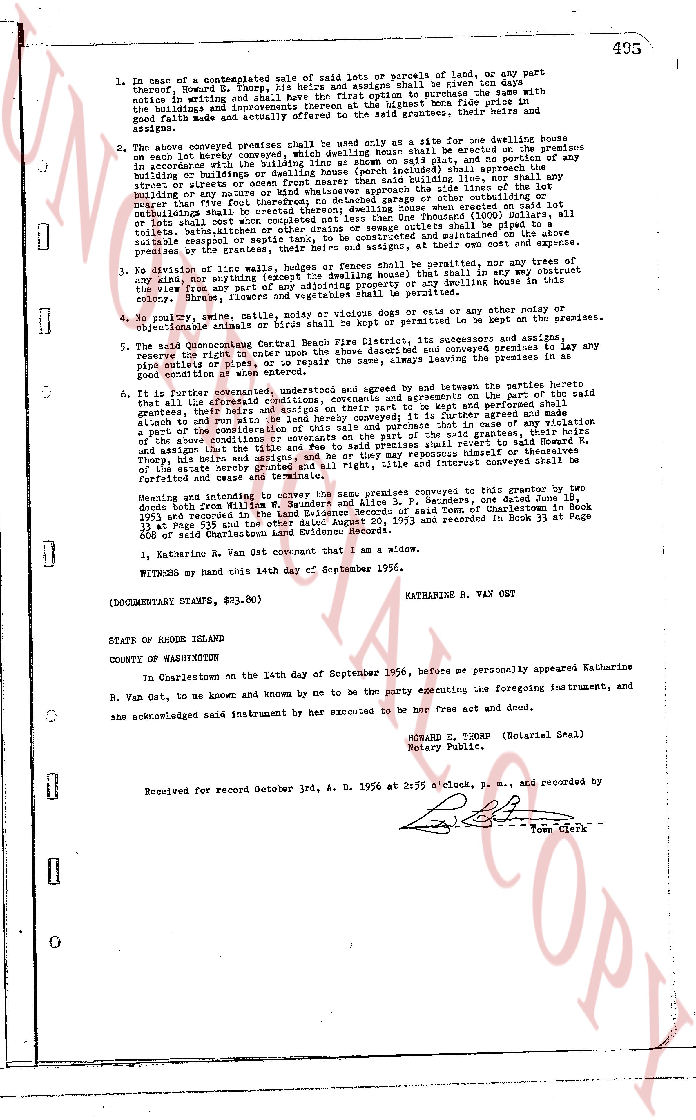
495
1. In case of a contemplated sale of said lots or a parcele of land, or any part thereof, Howard E. Thorp, his heirs and assigns shall be given ten days notice in writing and thereof shall have the first option to purchase the same with the buildings and improvements thereon at the then highest bona fide price in good faith and actually offered to said the grantees, their heirs and assigns.
2. The above conveyed premises shall be used only as a site for one dwelling house on each lot hereby conveyed, which dwelling house shall be erected on the premises in accordance with the restrictions contained in said Plat, and no portion of any buildings or dwellings or dwelling house (porch included) shall approach the streets or streets or ocean frontier nearer than said the side lines of the lot building lines, nor shall any building or dwellings or dwelling house be erected on said lots or parcels nearer than five feet therefrom or detached garage or other suitable outbuilding or outhouse shall be erected on said lots or parcels, and no lots or parcels shall be completed not less than One Thousand (1000) Dollars, all toilets, bathing tubs and kitchen sinks in said dwellings shall be provided with suitable cesspool or septic tank, to be constructed and maintained on the above premises by the grantees at their own expense and at their own cost.
3. No division of line via walls, hedges or fences shall be permitted, nor any trees of any sort (excepting the swept the dwelling house) that in any way obstruct the view from any part of any lot or parcel to the ocean, any dwelling house, cottage, shrubbery, flowers, and vegetables shall be permitted.
4. No poultry, swine, cattle, noisy or vicious dogs or cats or any other noisy or objectionable animals or birds shall be kept or permitted to be kept on the premises.
5. The said Quonochontaug Central Beach Fire District, its successors and assigns, reserve the right to enter on the premises and to install and convey premises lay to any pipe culverts or pipes or conduits, or to repair the same, always in leaving the premises in as good condition as when entered.
6. It is further covenanted, understood and agreed by and between the parties hereto that all the aforesaid conditions, covenants and agreements on the part of the said grantees, their heirs and assigns shall be and remain in full force and be kept and performed shall attach to and run with the land hereby conveyed; it is further agreed and made the part of the consideration of this conveyance that in case of any violation of the above conditions or of any covenants on the part of the said grantees, their heirs and assigns that the title and fee to said shall revert to said Howard E. Thorp or his heirs or assigns and that the title and fee to same may repossess himself or themselves of the estate hereby granted and all right, title and interest conveyed shall be forfeited and cease to exist.
Meaning and intending to convey the same premises conveyed to the same Grantor, two deeds both from William W. Saunders and Alice B. P. Saunders, one date June 18, 1953 and recorded in Charlestown Land Evidence Book 33 page 539 and the other dated August 20, 1953 and recorded in Book 33 at Page 608 of said Charlestown Land Evidence Record.
1. Katharine R. Van Ost covenant that I am a widow.
WITNESS my hand this 14th day of September 1956.
KATHARINE R. VAN OST
(DOCUMENTARY STAMPS, $23.80)
STATE OF RHODE ISLAND
COUNTY OF WASHINGTON
In Charlestown on the 14th day of September 1956, before me personally appeared Katharine R. Van Ost, to me known and by me to be the party executing the foregoing instrument, and she acknowledged said instrument by her executed to be her free act and deed.
HOWARD E. THORP (Notarial Seal)
Notary Public.
Received for record October 3rd, A. D. 1956 at 2:55 o'clock, P. M., and recorded by [Signature] Town Clerk
The page as recorded