The instrument's own words
page 1
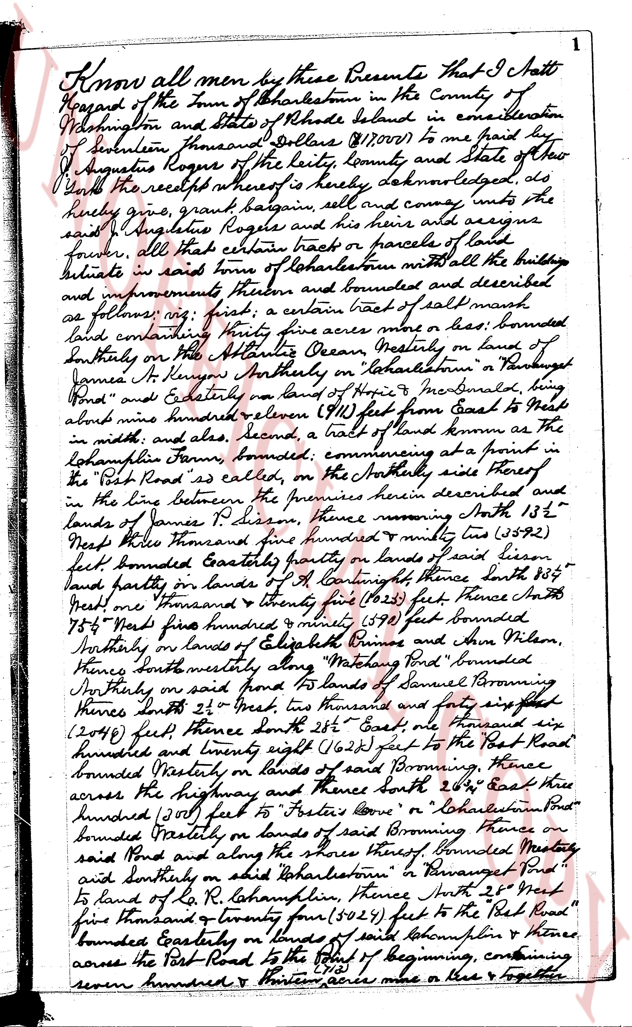
Know all men by these Presents That I Jatt
Hazard of the Town of Charlestown in the County of
Washington and State of Rhode Island in consideration
of seventeen thousand Dollars ($17,000) to me paid by
J Augustus Rogue of the city, county and state of New
York the receipt whereof is hereby acknowledged do
hereby give, grant bargain sell and convey unto the
said J Augustus Rogue and his heirs and assigns
forever, all that certain tract or parcels of land
situate in said town of Charlestown with all the buildings
and improvements thereon and bounded and described
as follows: viz: first; a certain tract of salt marsh
land containing ninety five acres more or less; bounded
Southerly on the Atlantic Ocean, Westerly on land of
James A Kenyon Ancestry on "Charlestown" a Passage
"Pond" and Easterly on land of Hope M McDonald, long
about nine hundred eleven (911) feet from East to West
in width, and also, second, a tract of land known as the
"Cohamphlin Farm", bounded; commencing at a point in
the "Post Road" as called, on the Northerly side thereof
in the line between the premises herein described and
lands of James P Dean, thence running North 13 1/2°
West three thousand five hundred ninety two (3592)
feet bounded Easterly partly on lands of said Dean
land partly on lands of A Cuttingh thence South 85 1/4°
West one thousand twenty five (1025) feet Thence South
75 1/4° West five hundred ninety one (591) feet bounded
Southerly on lands of Elizabeth Primes and John Wilson
thence South westerly along "Matunuck Pond" bounded
Northerly on said Pond to lands of Samuel Parrington
thence South 25° West two thousand and sixty six
(2066) feet thence South 25 1/2° East one thousand
six hundred twenty eight (1628) feet to the "Post Road"
bounded Westerly on lands of said Browning, thence
across the highway and thence South 26 1/2° East three
hundred (300) feet to "Foster's Cove" or "Cohamphlin Pond"
bounded Easterly on lands of said Browning thence on
said Pond and along the shores thereof bounded Westerly
and Southerly on said Charlestown or "Ravaget Pond"
to land of R. R. Cohamphlin, thence South 25° West
two thousand twenty four (2024) feet to the "Post Road"
bounded Easterly on lands of said Cohamphlin & thence
across the "Post Road" to the point of beginning, containing
seven hundred & fourteen acres more or less & together
page 2
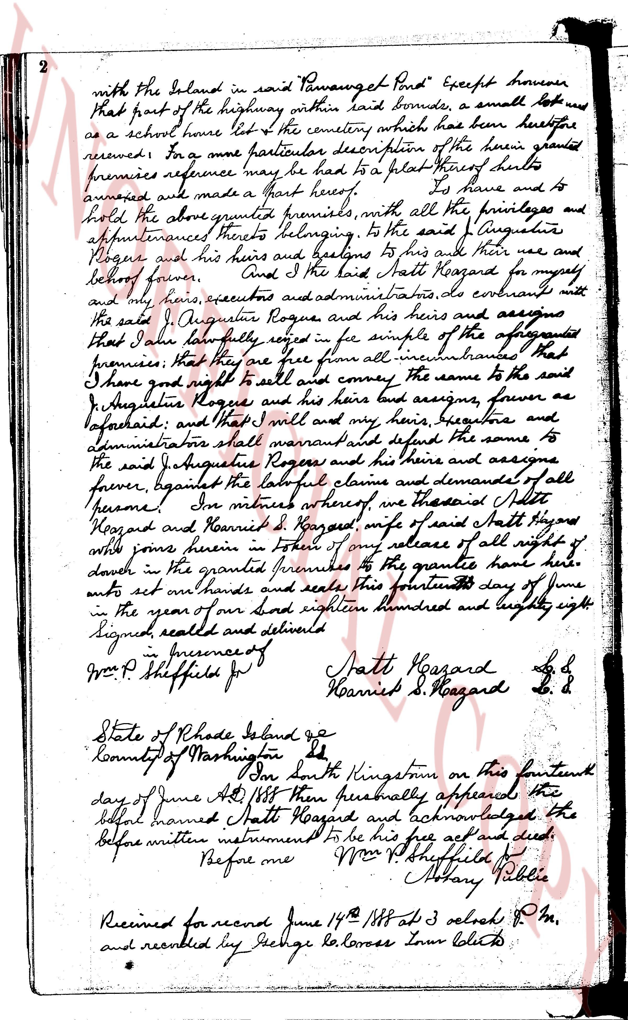
with the Island in said "Pawaughet Pond" Except however
that part of the highway within said bounds, a small lot used
as a school house lot & the cemetery which has been heretofore
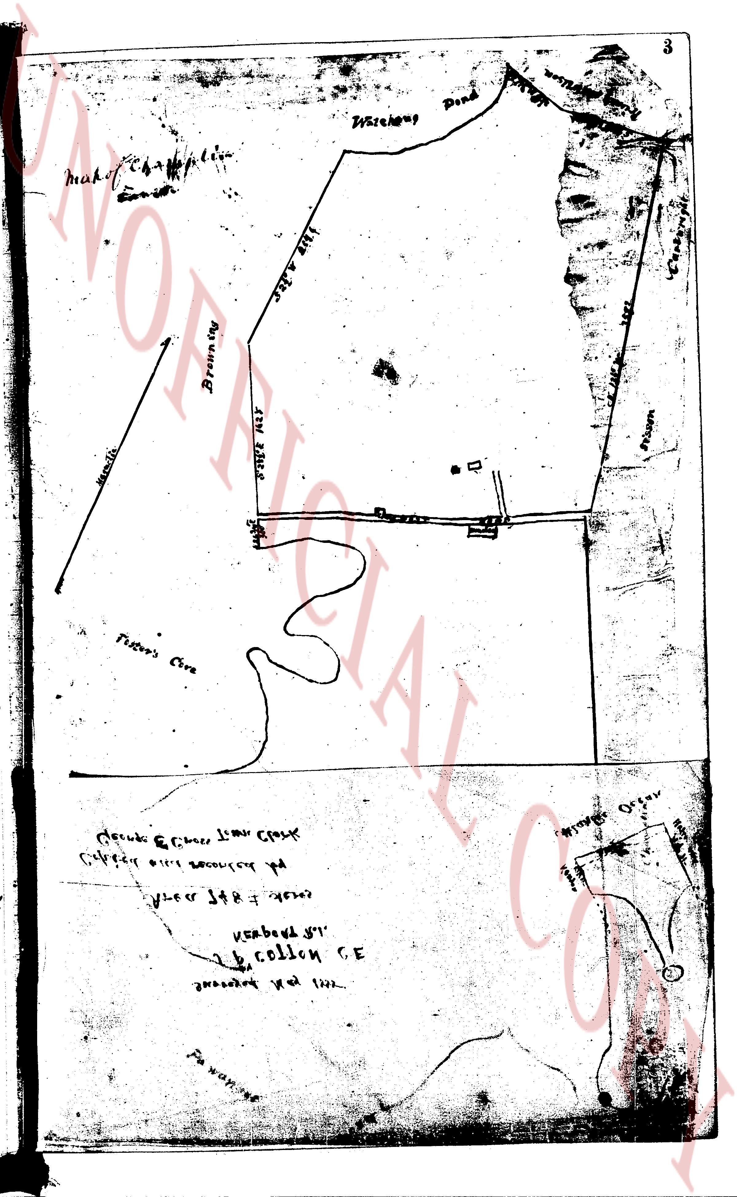
reserved. For a more particular description of the herein granted
premises reference may be had to a plat thereof which
annexed are made a Part hereof. To have and to
hold the above granted premises, with all the privileges and
appurtenances thereto belonging, to the said J. Augustus
Rogue and his heirs and bastard to his and their use and
behalf forever. And I the said Matt Hazard for myself,
and my heirs, executors and administrators, do covenant with
the said J. Augustus Rogue and his heirs and assigns
that I have lawfully seised in fee simple of the aforesaid
premises; that they are free from all incumbrances that
I have good right to sell and convey the same to the said
J. Augustus Rogue and his heirs and assigns, forever as
aforesaid and that I will and my heirs, devisees and
administrators shall warrant and defend the same to
the said J. Augustus Rogue and his heirs and assigns
forever, against the lawful claims and demands of all
persons. In witness whereof we the aforesaid Matt
Hazard and Harriet D. Hazard, wife of said Matt Hazard
whose joins herein in token of my release of all right of
dower in the granted premises to the grantee have here
unto set our hands and seals this fourteenth day of June
in the year of our Lord eighteen hundred and eighty eight.
Signed, sealed and delivered
in presence of
Wm P Sheffield Jr
Matt Hazard L.S.
Harriet D. Hazard L.S.
State of Rhode Island ge
County of Washington ss
On South Kingston on this fourteenth
day of June A.D. 1888 then personally appeared the
before named Matt Hazard and acknowledged the
before written instrument to be his free act and deed
Before me
Wm P Sheffield Jr
Notary Public
Received for record June 14th 1888 at 3 oclock P.M.
and recorded by J. George Balance Town Clerk
page 3
3
make of Chaplin
Wickhop Pond
Browns
S. 22 E 425'
S. 15 E 107'
S. 15 E 107'
S. 15 E 107'
S. 15 E 107'
S. 15 E 107'
S. 15 E 107'
S. 15 E 107'
S. 15 E 107'
S. 15 E 107'
S. 15 E 107'
S. 15 E 107'
S. 15 E 107'
S. 15 E 107'
S. 15 E 107'
S. 15 E 107'
S. 15 E 107'
S. 15 E 107'
S. 15 E 107'
S. 15 E 107'
S. 15 E 107'
S. 15 E 107'
S. 15 E 107'
S. 15 E 107'
S. 15 E 107'
S. 15 E 107'
S. 15 E 107'
S. 15 E 107'
S. 15 E 107'
S. 15 E 107'
S. 15 E 107'
S. 15 E 107'
S. 15 E 107'
S. 15 E 107'
S. 15 E 107'
S. 15 E 107'
S. 15 E 107'
S. 15 E 107'
S. 15 E 107'
S. 15 E 107'
S. 15 E 107'
S. 15 E 107'
S. 15 E 107'
S. 15 E 107'
S. 15 E 107'
S. 15 E 107'
S. 15 E 107'
S. 15 E 107'
S. 15 E 107'
S. 15 E 107'
S. 15 E 107'
S. 15 E 107'
S. 15 E 107'
S. 15 E 107'
S. 15 E 107'
S. 15 E 107'
S. 15 E 107'
S. 15 E 107'
S. 15 E 107'
S. 15 E 107'
S. 15 E 107'
S. 15 E 107'
S. 15 E 107'
S. 15 E 107'
S. 15 E 107'
S. 15 E 107'
S. 15 E 107'
S. 15 E 107'
S. 15 E 107'
S. 15 E 107'
S. 15 E 107'
S. 15 E 107'
S. 15 E 107'
S. 15 E 107'
S. 15 E 107'
S. 15 E 107'
S. 15 E 107'
S. 15 E 107'
S. 15 E 107'
S. 15 E 107'
S. 15 E 107'
S. 15 E 107'
S. 15 E 107'
S. 15 E 107'
S. 15 E 107'
S. 15 E 107'
S. 15 E 107'
S. 15 E 107'
S. 15 E 107'
S. 15 E 107'
S. 15 E 107'
S. 15 E 107'
S. 15 E 107'
S. 15 E 107'
S. 15 E 107'
S. 15 E 107'
S. 15 E 107'
S. 15 E 107'
S. 15 E 107'
S. 15 E 107'
S. 15 E 107'
S. 15 E 107'
S. 15 E 107'
S. 15 E 107'
S. 15 E 107'
S. 15 E 107'
S. 15 E 107'
S. 15 E 107'
S. 15 E 107'
S. 15 E 107'
S. 15 E 107'
S. 15 E 107'
S. 15 E 107'
S. 15 E 107'
S. 15 E 107'
S. 15 E 107'
S. 15 E 107'
S. 15 E 107'
S. 15 E 107'
S. 15 E 107'
S. 15 E 107'
S. 15 E 107'
S. 15 E 107'
S. 15 E 107'
S. 15 E 107'
S. 15 E 107'
S. 15 E 107'
S. 15 E 107'
S. 15 E 107'
S. 15 E 107'
S. 15 E 107'
S. 15 E 107'
S. 15 E 107'
S. 15 E 107'
S. 15 E 107'
S. 15 E 107'
S. 15 E 107'
S. 15 E 107'
S. 15 E 107'
S. 15 E 107'
S. 15 E 107'
S. 15 E 107'
S. 15 E 107'
S. 15 E 107'
S. 15 E 107'
S. 15 E 107'
S. 15 E 107'
S. 15 E 107'
S. 15 E 107'
S. 15 E 107'
S. 15 E 107'
S. 15 E 107'
S. 15 E 107'
S. 15 E 107'
S. 15 E 107'
S. 15 E 107'
S. 15 E 107'
S. 15 E 107'
S. 15 E 107'
S. 15 E 107'
S. 15 E 107'
S. 15 E 107'
S. 15 E 107'
S. 15 E 107'
S. 15 E 107'
S. 15 E 107'
S. 15 E 107'
S. 15 E 107'
S. 15 E 107'
S. 15 E 107'
S. 15 E 107'
S. 15 E 107'
S. 15 E 107'
S. 15 E 107'
S. 15 E 107'
S. 15 E 107'
S. 15 E 107'
S. 15 E 107'
S. 15 E 107'
S. 15 E 107'
S. 15 E 107'
S. 15 E 107'
S. 15 E 107'
S. 15 E 107'
S. 15 E 107'
S. 15 E 107'
S. 15 E 107'
S. 15 E 107'
S. 15 E 107'
S. 15 E 107'
S. 15 E 107'
S. 15 E 107'
S. 15 E 107'
S. 15 E 107'
S. 15 E 107'
S. 15 E 107'
S. 15 E 107'
S. 15 E 107'
S. 15 E 107'
S. 15 E 107'
S. 15 E 107'
S. 15 E 107'
S. 15 E 107'
S. 15 E 107'
S. 15 E 107'
S. 15 E 107'
S. 15 E 107'
S. 15 E 107'
S. 15 E 107'
S. 15 E 107'
S. 15 E 107'
S. 15 E 107'
S. 15 E 107'
S. 15 E 107'
S. 15 E 107'
S. 15 E 107'
S. 15 E 107'
S. 15 E 107'
S. 15 E 107'
S. 15 E 107'
S. 15 E 107'
S. 15 E 107'
S. 15 E 107'
S. 15 E 107'
S. 15 E 107'
S. 15 E 107'
S. 15 E 107'
S. 15 E 107'
S. 15 E 107'
S. 15 E 107'
S. 15 E 107'
S. 15 E 107'
S. 15 E 107'
S. 15 E 107'
S. 15 E 107'
S. 15 E 107'
S. 15 E 107'
S. 15 E 107'
S. 15 E 107'
S. 15 E 107'
S. 15 E 107'
S. 15 E 107'
S. 15 E 107'
S. 15 E 107'
S. 15 E 107'
S. 15 E 107'
S. 15 E 107'
S. 15 E 107'
S. 15 E 107'
S. 15 E 107'
S. 15 E 107'
S. 15 E 107'
S. 15 E 107'
S. 15 E 107'
S. 15 E 107'
S. 15 E 107'
S. 15 E 107'
S. 15 E 107'
S. 15 E 107'
S. 15 E 107'
S. 15 E 107'
S. 15 E 107'
S. 15 E 107'
S. 15 E 107'
S. 15 E 107'
S. 15 E
The page as recorded