The instrument's own words
page 1 · read by Gemma vision
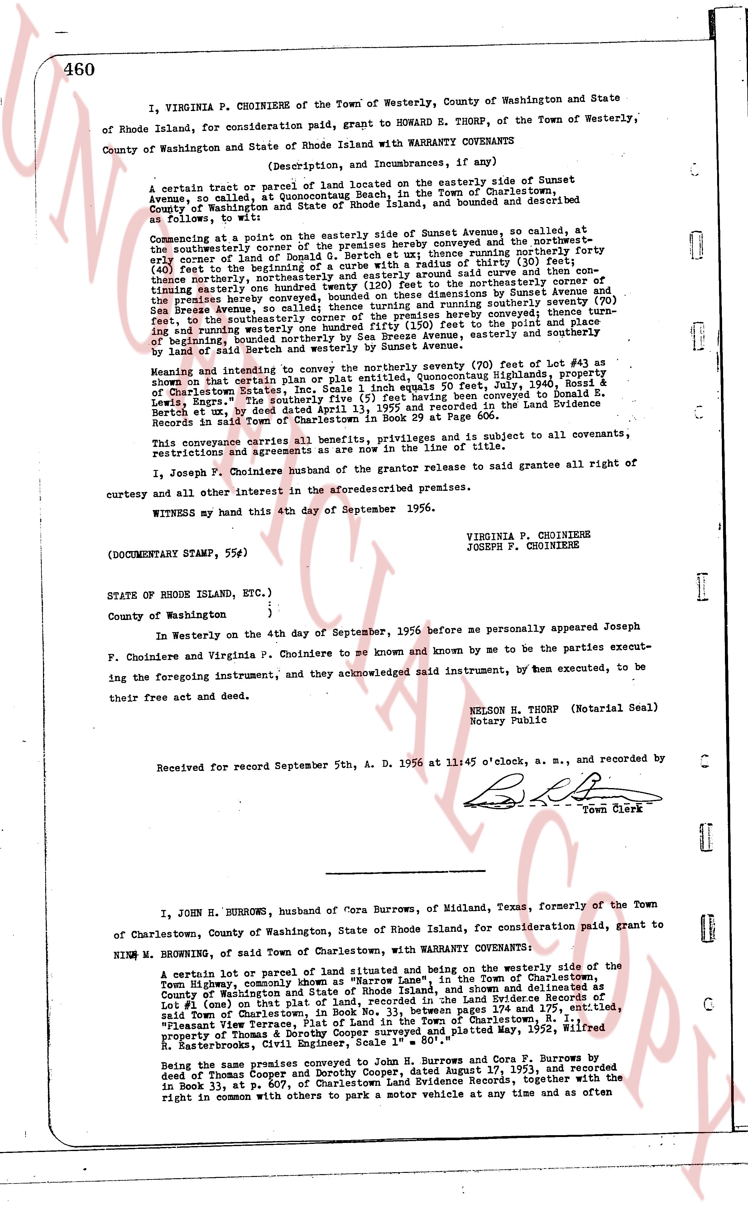
460
I, VIRGINIA P. CHOINIERE of the Town of Westerly, County of Washington and State of Rhode Island, for consideration paid, grant to HOWARD E. THORP, of the Town of Westerly, County of Washington and State of Rhode Island with WARRANTY COVENANTS
(Description, and Incumbrances, if any)
A certain tract or parcel of land located on the easterly side of Sunset Avenue, so called at Quonochontaug Beach, in the Town of Charlestown, County of Washington and State of Rhode Island, land and bounded and described as follows, to wit:
Commencing at a point on the easterly side of Sunset Avenue, so called, at the southeasterly corner of the premises hereby conveyed and the northwesternmost early corner of land of Donald G. Bertch et al., thence running northerly forty (40) feet to the beginning of a curve running easterly with a radius of thirty (30) feet, (40) feet to the beginning of a curve running easterly with a radius of thirty (30) feet, thence northerly, northeasterly and easterly around said curve and then continuing easterly one hundred forty (140) feet to the northeasterly corner of the premises hereby conveyed, bounded on these dimensions by Sunset Avenue and Sea Breeze Avenue, so called, thence running southerly, running southerly seventy (70) feet to the southeasterly corner of the premises hereby conveyed thence turn westward and running westerly one hundred forty (140) feet to the south and easterly end of beginning bounded southerly and easterly by Sea Breeze Avenue, easterly and southerly by land of Bertch southerly and westerly by Sunset Avenue.
Meaning and intending to convey the northerly seventy (70) feet of lot #43 as shown on that certain plat of land located at Quonochontaug Highlands, property of Charlestown Estates, Inc. Scale 1 inch equals 50 feet, Aug. 2, 1949, filed at Charlestown Estates, Inc. Scale 1 inch equals 50 feet, Aug. 2, 1949, filed at Charlestown Estates, Inc. Scale 1 inch equals 50 feet, Aug. 2, 1949, filed at Charlestown Estates, Inc. Scale 1 inch equals 50 feet, Aug. 2, 1949, filed at Charlestown Estates, Inc. Scale 1 inch equals 50 feet, Aug. 2, 1949, filed at Charlestown Estates, Inc. Scale 1 inch equals 50 feet, Aug. 2, 1949, filed at Charlestown Estates, Inc. Scale 1 inch equals 50 feet, Aug. 2, 1949, filed at Charlestown Estates, Inc. Scale 1 inch equals 50 feet, Aug. 2, 1949, filed at Charlestown Estates, Inc. Scale 1 inch equals 50 feet, Aug. 2, 1949, filed at Charlestown Estates, Inc. Scale 1 inch equals 50 feet, Aug. 2, 1949, filed at Charlestown Estates, Inc. Scale 1 inch equals 50 feet, Aug. 2, 1949, filed at Charlestown Estates, Inc. Scale 1 inch equals 50 feet, Aug. 2, 1949, filed at Charlestown Estates, Inc. Scale 1 inch equals 50 feet, Aug. 2, 1949, filed at Charlestown Estates, Inc. Scale 1 inch equals 50 feet, Aug. 2, 1949, filed at Charlestown Estates, Inc. Scale 1 inch equals 50 feet, Aug. 2, 1949, filed at Charlestown Estates, Inc. Scale 1 inch equals 50 feet, Aug. 2, 1949, filed at Charlestown Estates, Inc. Scale 1 inch equals 50 feet, Aug. 2, 1949, filed at Charlestown Estates, Inc. Scale 1 inch equals 50 feet, Aug. 2, 1949, filed at Charlestown Estates, Inc. Scale 1 inch equals 50 feet, Aug. 2, 1949, filed at Charlestown Estates, Inc. Scale 1 inch equals 50 feet, Aug. 2, 1949, filed at Charlestown Estates, Inc. Scale 1 inch equals 50 feet, Aug. 2, 1949, filed at Charlestown Estates, Inc. Scale 1 inch equals 50 feet, Aug. 2, 1949, filed at Charlestown Estates, Inc. Scale 1 inch equals 50 feet, Aug. 2, 1949, filed at Charlestown Estates, Inc. Scale 1 inch equals 50 feet, Aug. 2, 1949, filed at Charlestown Estates, Inc. Scale 1 inch equals 50 feet, Aug. 2, 1949, filed at Charlestown Estates, Inc. Scale 1 inch equals 50 feet, Aug. 2, 1949, filed at Charlestown Estates, Inc. Scale 1 inch equals 50 feet, Aug. 2, 1949, filed at Charlestown Estates, Inc. Scale 1 inch equals 50 feet, Aug. 2, 1949, filed at Charlestown Estates, Inc. Scale 1 inch equals 50 feet, Aug. 2, 1949, filed at Charlestown Estates, Inc. Scale 1 inch equals 50 feet, Aug. 2, 1949, filed at Charlestown Estates, Inc. Scale 1 inch equals 50 feet, Aug. 2, 1949, filed at Charlestown Estates, Inc. Scale 1 inch equals 50 feet, Aug. 2, 1949, filed at Charlestown Estates, Inc. Scale 1 inch equals 50 feet, Aug. 2, 1949, filed at Charlestown Estates, Inc. Scale 1 inch equals 50 feet, Aug. 2, 1949, filed at Charlestown Estates, Inc. Scale 1 inch equals 50 feet, Aug. 2, 1949, filed at Charlestown Estates, Inc. Scale 1 inch equals 50 feet, Aug. 2, 1949, filed at Charlestown Estates, Inc. Scale 1 inch equals 50 feet, Aug. 2, 1949, filed at Charlestown Estates, Inc. Scale 1 inch equals 50 feet, Aug. 2, 1949, filed at Charlestown Estates, Inc. Scale 1 inch equals 50 feet, Aug. 2, 1949, filed at Charlestown Estates, Inc. Scale 1 inch equals 50 feet, Aug. 2, 1949, filed at Charlestown Estates, Inc. Scale 1 inch equals 50 feet, Aug. 2, 1949, filed at Charlestown Estates, Inc. Scale 1 inch equals 50 feet, Aug. 2, 1949, filed at Charlestown Estates, Inc. Scale 1 inch equals 50 feet, Aug. 2, 1949, filed at Charlestown Estates, Inc. Scale 1 inch equals 50 feet, Aug. 2, 1949, filed at Charlestown Estates, Inc. Scale 1 inch equals 50 feet, Aug. 2, 1949, filed at Charlestown Estates, Inc. Scale 1 inch equals 50 feet, Aug. 2, 1949, filed at Charlestown Estates, Inc. Scale 1 inch equals 50 feet, Aug. 2, 1949, filed at Charlestown Estates, Inc. Scale 1 inch equals 50 feet, Aug. 2, 1949, filed at Charlestown Estates, Inc. Scale 1 inch equals 50 feet, Aug. 2, 1949, filed at Charlestown Estates, Inc. Scale 1 inch equals 50 feet, Aug. 2, 1949, filed at Charlestown Estates, Inc. Scale 1 inch equals 50 feet, Aug. 2, 1949, filed at Charlestown Estates, Inc. Scale 1 inch equals 50 feet, Aug. 2, 1949, filed at Charlestown Estates, Inc. Scale 1 inch equals 50 feet, Aug. 2, 1949, filed at Charlestown Estates, Inc. Scale 1 inch equals 50 feet, Aug. 2, 1949, filed at Charlestown Estates, Inc. Scale 1 inch equals 50 feet, Aug. 2, 1949, filed at Charlestown Estates, Inc. Scale 1 inch equals 50 feet, Aug. 2, 1949, filed at Charlestown Estates, Inc. Scale 1 inch equals 50 feet, Aug. 2, 1949, filed at Charlestown Estates, Inc. Scale 1 inch equals 50 feet, Aug. 2, 1949, filed at Charlestown Estates, Inc. Scale 1 inch equals 50 feet, Aug. 2, 1949, filed at Charlestown Estates, Inc. Scale 1 inch equals 50 feet, Aug. 2, 1949, filed at Charlestown Estates, Inc. Scale 1 inch equals 50 feet, Aug. 2, 1949, filed at Charlestown Estates, Inc. Scale 1 inch equals 50 feet, Aug. 2, 1949, filed at Charlestown Estates, Inc. Scale 1 inch equals 50 feet, Aug. 2, 1949, filed at Charlestown Estates, Inc. Scale 1 inch equals 50 feet, Aug. 2, 1949, filed at Charlestown Estates, Inc. Scale 1 inch equals 50 feet, Aug. 2, 1949, filed at Charlestown Estates, Inc. Scale 1 inch equals 50 feet, Aug. 2, 1949, filed at Charlestown Estates, Inc. Scale 1 inch equals 50 feet, Aug. 2, 1949, filed at Charlestown Estates, Inc. Scale 1 inch equals 50 feet, Aug. 2, 1949, filed at Charlestown Estates, Inc. Scale 1 inch equals 50 feet, Aug. 2, 1949, filed at Charlestown Estates, Inc. Scale 1 inch equals 50 feet, Aug. 2, 1949, filed at Charlestown Estates, Inc. Scale 1 inch equals 50 feet, Aug. 2, 1949, filed at Charlestown Estates, Inc. Scale 1 inch equals 50 feet, Aug. 2, 1949, filed at Charlestown Estates, Inc. Scale 1 inch equals 50 feet, Aug. 2, 1949, filed at Charlestown Estates, Inc. Scale 1 inch equals 50 feet, Aug. 2, 1949, filed at Charlestown Estates, Inc. Scale 1 inch equals 50 feet, Aug. 2, 1949, filed at Charlestown Estates, Inc. Scale 1 inch equals 50 feet, Aug. 2, 1949, filed at Charlestown Estates, Inc. Scale 1 inch equals 50 feet, Aug. 2, 1949, filed at Charlestown Estates, Inc. Scale 1 inch equals 50 feet, Aug. 2, 1949, filed at Charlestown Estates, Inc. Scale 1 inch equals 50 feet, Aug. 2, 1949, filed at Charlestown Estates, Inc. Scale 1 inch equals 50 feet, Aug. 2, 1949, filed at Charlestown Estates, Inc. Scale 1 inch equals 50 feet, Aug. 2, 1949, filed at Charlestown Estates, Inc. Scale 1 inch equals 50 feet, Aug. 2, 1949, filed at Charlestown Estates, Inc. Scale 1 inch equals 50 feet, Aug. 2, 1949, filed at Charlestown Estates, Inc. Scale 1 inch equals 50 feet, Aug. 2, 1949, filed at Charlestown Estates, Inc. Scale 1 inch equals 50 feet, Aug. 2, 1949, filed at Charlestown Estates, Inc. Scale 1 inch equals 50 feet, Aug. 2, 1949, filed at Charlestown Estates, Inc. Scale 1 inch equals 50 feet, Aug. 2, 1949, filed at Charlestown Estates, Inc. Scale 1 inch equals 50 feet, Aug. 2, 1949, filed at Charlestown Estates, Inc. Scale 1 inch equals 50 feet, Aug. 2, 1949, filed at Charlestown Estates, Inc. Scale 1 inch equals 5
page 2 · read by Gemma vision
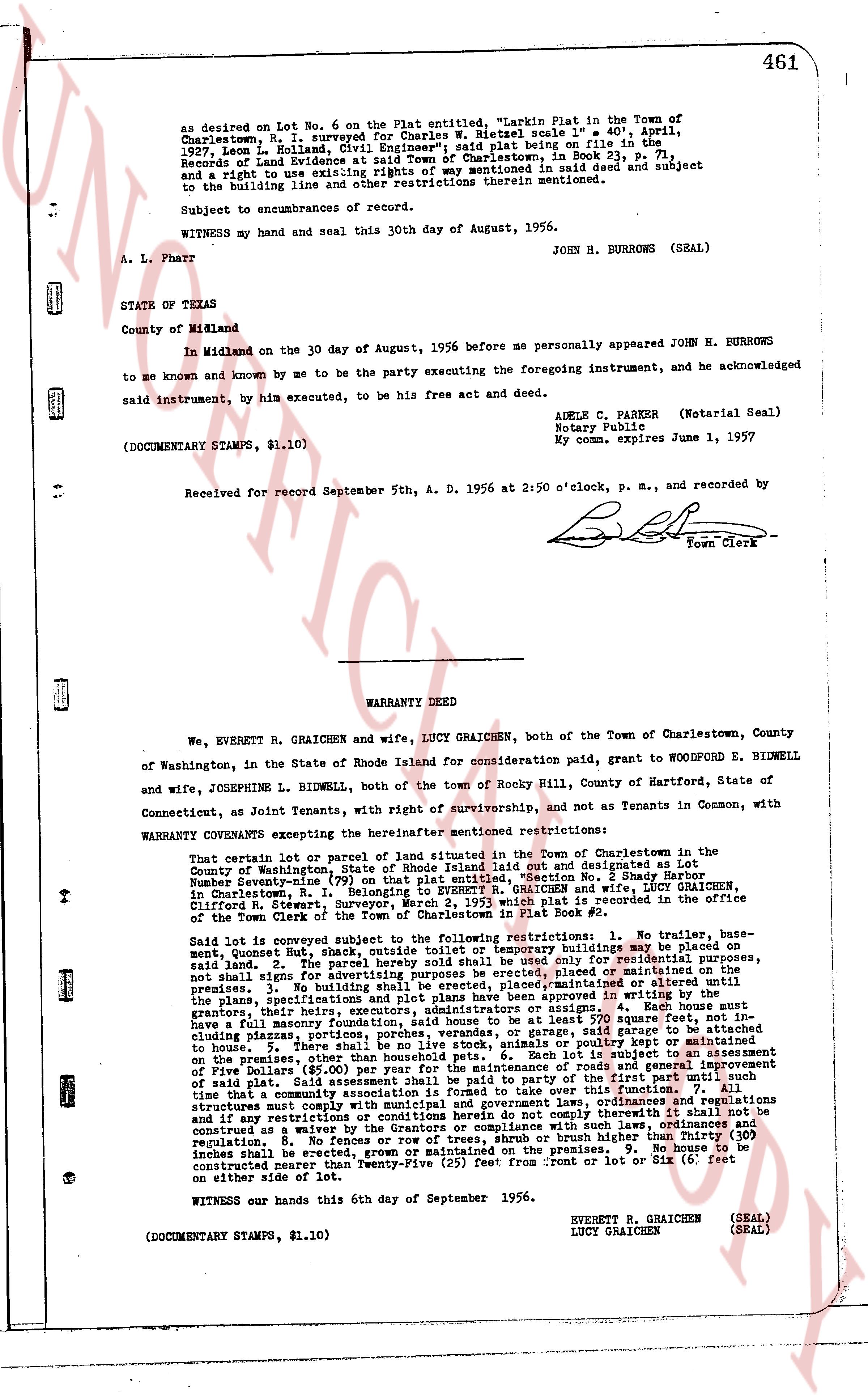
as desired on Lot No. 6 on the Plat entitled, "Larkin Plat in the Town of
Charlestown, R. I. surveyed for Charles W. Rietzel scale 1" = 40', April,
1927, Leon L. Holland, Civil Engineer"; said plat being on file in the
Records of Land Evidence at said Town of Charlestown, in Book 31, Page 7,
and a right to use existing 10' wide road as mentioned in said deed and subject
to the building line and other restrictions therein mentioned.
Subject to encumbrances of record.
WITNESS my hand and seal this 30th day of August, 1956.
JOHN H. BURROWS (SEAL)
A. L. Pharr
STATE of TEXAS
County of Midland
In Midland on the 30 day of August, 1956 before me personally appeared JOHN H. BURROWS
to me known and known by me to be the party executing the foregoing instrument, and he acknowledged
said instrument, by him executed, to be his free act and deed.
ADELE C. PARKER (Notarial Seal)
Notary Publicle
My com. expires June 1, 1957
(DOCUMENTARY STAMPS, $1.10)
Received for record September 5th, A. D. 1956 at 2:50 o'clock, p. m., and recorded by
[Signature]
Town Clerk
----
WARRANTY DEED
We, EVERETT R. GRAICHEN and wife, LUCY GRAICHEN, both of the Town of Charlestown, County
of Washington, in the State of Rhode Island for consideration paid, grant to WOODFORD E. BIDWELL
and wife, JOSEPHINE L. BIDWELL, both of the Town of Rocky Hill, County of Hartford, State of
Connecticut, as Joint Tenants, with right of survivorship, and not as Tenants in Common, with
WARRANTY COVENANTS excepting the hereinafter mentioned restrictions:
That certain lot or parcel of land situated in the Town of Charlestown in the County of
Washington, in the State of Rhode Island, being set out and designated as Lot
Number twenty-one (21) on that plat entitled, "Section No. 2 Shady Hare" belonging to EVERETT R. GRAICHEN and wife, LUCY GRAICHEN,
in Charlestown, R. I. Conveyed to them in 1951 which plat is recorded in the office
of the Town Clerk of the Town of Charlestown in Plat Book #2.
Said lot is conveyed subject to the following restrictions: 1. No trailer, base-
ment, bonus room, that shall be open to the outside, or building may be placed on
said land. 2. The parcel hereby sold shall be used only for residence purposes,
not small for any commercial purpose, whether leased or maintained on the
premises. 3. No building shall be erected, placed, maintained or altered until
the plan is approved in writing by the owners of the adjacent lots, the
grantors, their heirs, successors, executors or administrators or assigns. 4. Each house must
have a full masonry foundation and shall not exceed 2,500 square feet in area including
glasses, porches, patios, porches, verandas, or garage, said garage to be attached
to the house. 5. There shall be no more than one household per lot. 6. Each lot is subject to an assessment
on the premise, $5.00 per year, said sum to be paid part of the first part until such
time that a community association is formed to take over the until the
restrictions, covenants and conditions. 7. All buildings shall, ordinances and regulations
and if any restrictions or conditions herein do not comply therewith be shall not be constructed without a waiver from the owners of said land as to such law or
regulation. 8. No fences or row of trees, shrub or brush higher than Thirty (30)
inches shall be erected within 10 feet of the premises. 9. No building may be
constructed nearer than Twenty-Five (25) feet from front or Six (6) feet on
either side of lot.
WITNESS our hands this 6th day of September 1956.
EVERETT R. GRAICHEN (SEAL)
LUCY GRAICHEN (SEAL)
(DOCUMENTARY STAMPS, $1.10)
The page as recorded