The instrument's own words
page 1 · read by Gemma vision
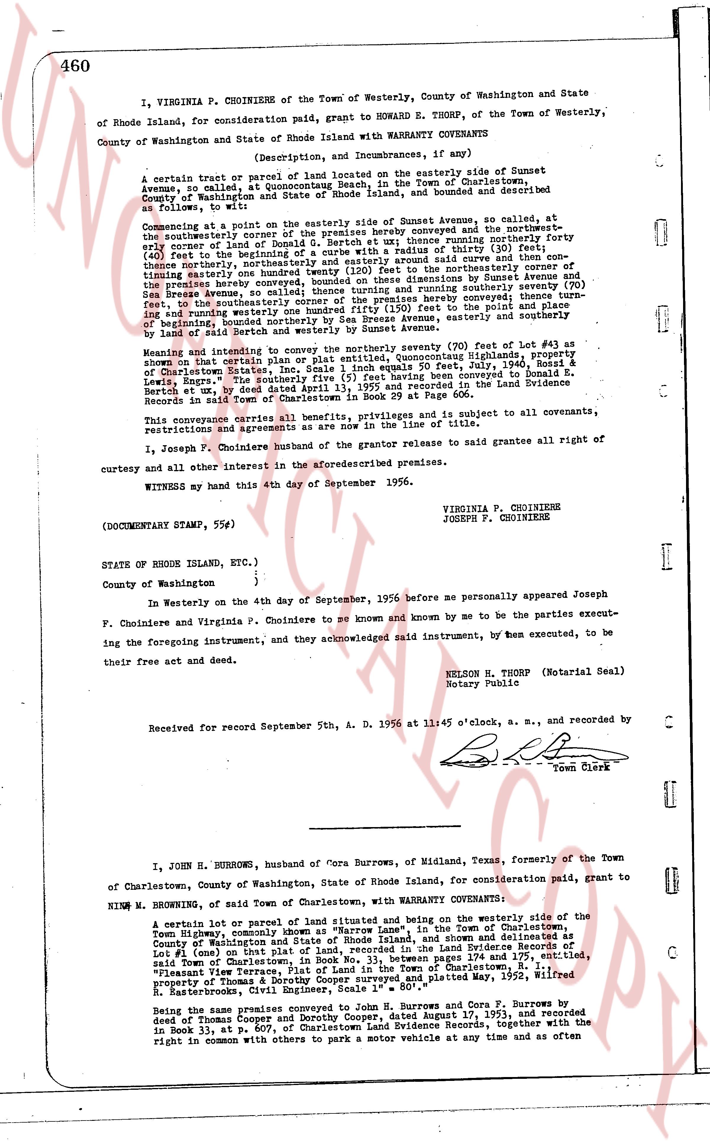
460
I, VIRGINIA P. CHOINIERE of the Town of Westerly, County of Washington and State of Rhode Island, for consideration paid, grant to HOWARD E. THORP, of the Town of Westerly, County of Washington and State of Rhode Island with WARRANTY COVENANTS
(Description, and Incumbrances, if any)
A certain tract or parcel of land located on the easterly side of Sunset Avenue, so called at Quonochontaug Beach, in the Town of Charlestown, County of Washington and State of Rhode Island, land and bounded and described as follows, to wit:
Commencing at a point on the easterly side of Sunset Avenue, so called, at the southeasterly corner of the premises hereby conveyed and the northwesternmost early corner of land of Donald G. Bertch et ux, thence running southerly forty (40) feet to the beginning of a curve running easterly with a radius of thirty (30) feet, (40) feet to the beginning of a curve running easterly with a radius of thirty (30) feet, thence northeasterly, thence northeasterly as oriented said curve and then running due north easterly one hundred forty (140) feet to the northeasterly corner of the premises hereby conveyed, bounded on these dimensions by Sunset Avenue and Sea Breeze Avenue, so called, and bounded on the east by a line running southerly seventy (70) feet to the southeasterly corner of the premises hereby conveyed thence turn north easterly and running westerly one hundred forty (140) feet to the said line and bounded on the east by a line running southerly by Sea Breeze Avenue, easterly and southerly of beginning, bounded southerly by Sunset Avenue, easterly and southerly by meaning of land by said Bertch and westerly by Sunset Avenue.
Meaning and intending to convey the northerly seventy (70) feet of lot #43 as shown on that certain plat of land located at Quonochontaug Highlands, property of Charlestown Estates, Inc. Scale 1 inch equals 50 feet, Aug. 2nd, 1942, filed at Charlestown Estates, Inc. Scale 1 inch equals 50 feet, Aug. 2nd, 1942, filed at Charlestown Estates, Inc. Scale 1 inch equals 50 feet, Aug. 2nd, 1942, filed at Charlestown Estates, Inc. Scale 1 inch equals 50 feet, Aug. 2nd, 1942, filed at Charlestown Estates, Inc. Scale 1 inch equals 50 feet, Aug. 2nd, 1942, filed at Charlestown Estates, Inc. Scale 1 inch equals 50 feet, Aug. 2nd, 1942, filed at Charlestown Estates, Inc. Scale 1 inch equals 50 feet, Aug. 2nd, 1942, filed at Charlestown Estates, Inc. Scale 1 inch equals 50 feet, Aug. 2nd, 1942, filed at Charlestown Estates, Inc. Scale 1 inch equals 50 feet, Aug. 2nd, 1942, filed at Charlestown Estates, Inc. Scale 1 inch equals 50 feet, Aug. 2nd, 1942, filed at Charlestown Estates, Inc. Scale 1 inch equals 50 feet, Aug. 2nd, 1942, filed at Charlestown Estates, Inc. Scale 1 inch equals 50 feet, Aug. 2nd, 1942, filed at Charlestown Estates, Inc. Scale 1 inch equals 50 feet, Aug. 2nd, 1942, filed at Charlestown Estates, Inc. Scale 1 inch equals 50 feet, Aug. 2nd, 1942, filed at Charlestown Estates, Inc. Scale 1 inch equals 50 feet, Aug. 2nd, 1942, filed at Charlestown Estates, Inc. Scale 1 inch equals 50 feet, Aug. 2nd, 1942, filed at Charlestown Estates, Inc. Scale 1 inch equals 50 feet, Aug. 2nd, 1942, filed at Charlestown Estates, Inc. Scale 1 inch equals 50 feet, Aug. 2nd, 1942, filed at Charlestown Estates, Inc. Scale 1 inch equals 50 feet, Aug. 2nd, 1942, filed at Charlestown Estates, Inc. Scale 1 inch equals 50 feet, Aug. 2nd, 1942, filed at Charlestown Estates, Inc. Scale 1 inch equals 50 feet, Aug. 2nd, 1942, filed at Charlestown Estates, Inc. Scale 1 inch equals 50 feet, Aug. 2nd, 1942, filed at Charlestown Estates, Inc. Scale 1 inch equals 50 feet, Aug. 2nd, 1942, filed at Charlestown Estates, Inc. Scale 1 inch equals 50 feet, Aug. 2nd, 1942, filed at Charlestown Estates, Inc. Scale 1 inch equals 50 feet, Aug. 2nd, 1942, filed at Charlestown Estates, Inc. Scale 1 inch equals 50 feet, Aug. 2nd, 1942, filed at Charlestown Estates, Inc. Scale 1 inch equals 50 feet, Aug. 2nd, 1942, filed at Charlestown Estates, Inc. Scale 1 inch equals 50 feet, Aug. 2nd, 1942, filed at Charlestown Estates, Inc. Scale 1 inch equals 50 feet, Aug. 2nd, 1942, filed at Charlestown Estates, Inc. Scale 1 inch equals 50 feet, Aug. 2nd, 1942, filed at Charlestown Estates, Inc. Scale 1 inch equals 50 feet, Aug. 2nd, 1942, filed at Charlestown Estates, Inc. Scale 1 inch equals 50 feet, Aug. 2nd, 1942, filed at Charlestown Estates, Inc. Scale 1 inch equals 50 feet, Aug. 2nd, 1942, filed at Charlestown Estates, Inc. Scale 1 inch equals 50 feet, Aug. 2nd, 1942, filed at Charlestown Estates, Inc. Scale 1 inch equals 50 feet, Aug. 2nd, 1942, filed at Charlestown Estates, Inc. Scale 1 inch equals 50 feet, Aug. 2nd, 1942, filed at Charlestown Estates, Inc. Scale 1 inch equals 50 feet, Aug. 2nd, 1942, filed at Charlestown Estates, Inc. Scale 1 inch equals 50 feet, Aug. 2nd, 1942, filed at Charlestown Estates, Inc. Scale 1 inch equals 50 feet, Aug. 2nd, 1942, filed at Charlestown Estates, Inc. Scale 1 inch equals 50 feet, Aug. 2nd, 1942, filed at Charlestown Estates, Inc. Scale 1 inch equals 50 feet, Aug. 2nd, 1942, filed at Charlestown Estates, Inc. Scale 1 inch equals 50 feet, Aug. 2nd, 1942, filed at Charlestown Estates, Inc. Scale 1 inch equals 50 feet, Aug. 2nd, 1942, filed at Charlestown Estates, Inc. Scale 1 inch equals 50 feet, Aug. 2nd, 1942, filed at Charlestown Estates, Inc. Scale 1 inch equals 50 feet, Aug. 2nd, 1942, filed at Charlestown Estates, Inc. Scale 1 inch equals 50 feet, Aug. 2nd, 1942, filed at Charlestown Estates, Inc. Scale 1 inch equals 50 feet, Aug. 2nd, 1942, filed at Charlestown Estates, Inc. Scale 1 inch equals 50 feet, Aug. 2nd, 1942, filed at Charlestown Estates, Inc. Scale 1 inch equals 50 feet, Aug. 2nd, 1942, filed at Charlestown Estates, Inc. Scale 1 inch equals 50 feet, Aug. 2nd, 1942, filed at Charlestown Estates, Inc. Scale 1 inch equals 50 feet, Aug. 2nd, 1942, filed at Charlestown Estates, Inc. Scale 1 inch equals 50 feet, Aug. 2nd, 1942, filed at Charlestown Estates, Inc. Scale 1 inch equals 50 feet, Aug. 2nd, 1942, filed at Charlestown Estates, Inc. Scale 1 inch equals 50 feet, Aug. 2nd, 1942, filed at Charlestown Estates, Inc. Scale 1 inch equals 50 feet, Aug. 2nd, 1942, filed at Charlestown Estates, Inc. Scale 1 inch equals 50 feet, Aug. 2nd, 1942, filed at Charlestown Estates, Inc. Scale 1 inch equals 50 feet, Aug. 2nd, 1942, filed at Charlestown Estates, Inc. Scale 1 inch equals 50 feet, Aug. 2nd, 1942, filed at Charlestown Estates, Inc. Scale 1 inch equals 50 feet, Aug. 2nd, 1942, filed at Charlestown Estates, Inc. Scale 1 inch equals 50 feet, Aug. 2nd, 1942, filed at Charlestown Estates, Inc. Scale 1 inch equals 50 feet, Aug. 2nd, 1942, filed at Charlestown Estates, Inc. Scale 1 inch equals 50 feet, Aug. 2nd, 1942, filed at Charlestown Estates, Inc. Scale 1 inch equals 50 feet, Aug. 2nd, 1942, filed at Charlestown Estates, Inc. Scale 1 inch equals 50 feet, Aug. 2nd, 1942, filed at Charlestown Estates, Inc. Scale 1 inch equals 50 feet, Aug. 2nd, 1942, filed at Charlestown Estates, Inc. Scale 1 inch equals 50 feet, Aug. 2nd, 1942, filed at Charlestown Estates, Inc. Scale 1 inch equals 50 feet, Aug. 2nd, 1942, filed at Charlestown Estates, Inc. Scale 1 inch equals 50 feet, Aug. 2nd, 1942, filed at Charlestown Estates, Inc. Scale 1 inch equals 50 feet, Aug. 2nd, 1942, filed at Charlestown Estates, Inc. Scale 1 inch equals 50 feet, Aug. 2nd, 1942, filed at Charlestown Estates, Inc. Scale 1 inch equals 50 feet, Aug. 2nd, 1942, filed at Charlestown Estates, Inc. Scale 1 inch equals 50 feet, Aug. 2nd, 1942, filed at Charlestown Estates, Inc. Scale 1 inch equals 50 feet, Aug. 2nd, 1942, filed at Charlestown Estates, Inc. Scale 1 inch equals 50 feet, Aug. 2nd, 1942, filed at Charlestown Estates, Inc. Scale 1 inch equals 50 feet, Aug. 2nd, 1942, filed at Charlestown Estates, Inc. Scale 1 inch equals 50 feet, Aug. 2nd, 1942, filed at Charlestown Estates, Inc. Scale 1 inch equals 50 feet, Aug. 2nd, 1942, filed at Charlestown Estates, Inc. Scale 1 inch equals 50 feet, Aug. 2nd, 1942, filed at Charlestown Estates, Inc. Scale 1 inch equals 50 feet, Aug. 2nd, 1942, filed at Charlestown Estates, Inc. Scale 1 inch equals 50 feet, Aug. 2nd, 1942, filed at Charlestown Estates, Inc. Scale 1 inch equals 50 feet, Aug. 2nd, 1942, filed at Charlestown Estates, Inc. Scale 1 inch equals 50 feet, Aug. 2nd, 1942, filed at Charlestown Estates, Inc. Scale 1 inch equals 50 feet, Aug. 2nd, 1942, filed at Charlestown Estates, Inc. Scale 1 inch equals 50 feet, Aug. 2nd, 1942, filed at Charlestown Estates, Inc. Scale 1 inch equals 50 feet, Aug. 2nd, 1942, filed at Charlestown Estates, Inc. Scale 1 inch equals 50 feet, Aug. 2
The page as recorded